Arkansas: 5th State Since 2017 to Get Record Tropical Rain
Special Stories
19 Jul 2019 3:00 AM
Hurricane Barry made landfall on Saturday, July 13, 2019 in Louisiana. But, this is one storm that likely won't be remembered for the impacts at landfall, but instead, the effects afterwards.
Like many other tropical systems in the U.S., the inland threats can be even more devastating and long lasting than those at the coastline. While impacts at coastlines can be extreme, it is sometimes the impacts miles, or even hundreds of miles away from the coast that leave the biggest mark. Hurricane Barry will likely become a storm known for it's impact beyond landfall. Dropping extreme rainfall, resulting in catastrophic flooding in Arkansas.
https://www.facebook.com/WeatherNation/videos/vb.129524519873/2349049935336324/?type=2&theater
https://www.facebook.com/WeatherNation/videos/vb.129524519873/353914001967069/?type=2&theater
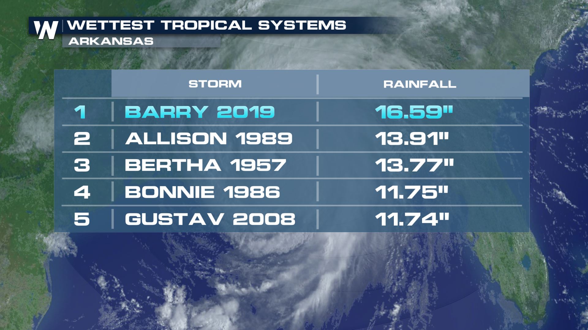
Barry set a new state record for wettest tropical cyclone to impact the state, dropping an unprecedented 16.59" near Dierks, Arkansas (as of 4pm ET 7/17/19). This total bumps tropical storm Allison (1989) from the top spot for most rainfall from a tropical system in 'The Natural State'.
 While not a #1 spot, Louisiana also had torrential rain fall from Barry, leaving behind nearly 2 feet of rainfall in Ragley, an unincorporated community in Beauregard Parish, Louisiana.
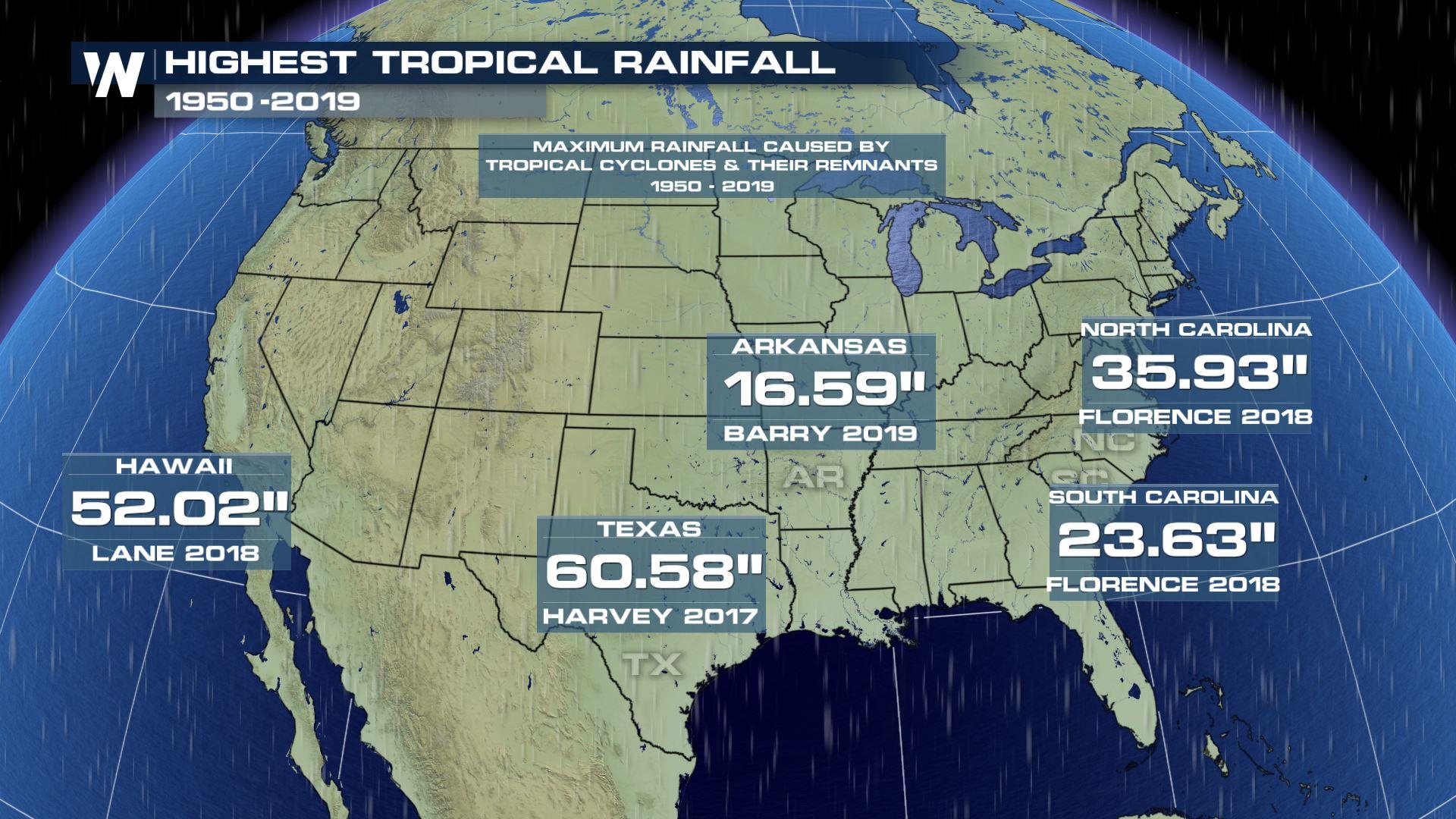
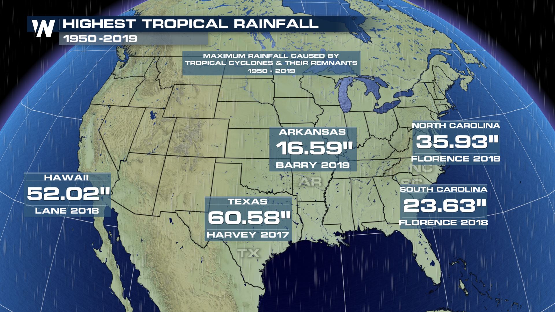
As Barry tops the list, now, for wettest tropical system for the state of Arkansas, that makes it the 5th state in the last 2 years to set the highest rainfall record from a tropical system. Hawaii, South Carolina, North Carolina, and Texas have also set the top record for most rainfall from a tropical system since 2017.
Texas - Hurricane Harvey (2017) : 60.58" (also a U.S. record for highest tropical rain in any state)
Hawaii - Hurricane Lane (2018) : 52.02"
North Carolina - Hurricane Florence (2018) : 35.93"
South Carolina - Hurricane Florence (2018) : 23.63"
Arkansas - Hurricane Barry (2019) : 16.59"
While not a #1 spot, Louisiana also had torrential rain fall from Barry, leaving behind nearly 2 feet of rainfall in Ragley, an unincorporated community in Beauregard Parish, Louisiana.
As Barry tops the list, now, for wettest tropical system for the state of Arkansas, that makes it the 5th state in the last 2 years to set the highest rainfall record from a tropical system. Hawaii, South Carolina, North Carolina, and Texas have also set the top record for most rainfall from a tropical system since 2017.
Texas - Hurricane Harvey (2017) : 60.58" (also a U.S. record for highest tropical rain in any state)
Hawaii - Hurricane Lane (2018) : 52.02"
North Carolina - Hurricane Florence (2018) : 35.93"
South Carolina - Hurricane Florence (2018) : 23.63"
Arkansas - Hurricane Barry (2019) : 16.59"
 Record rainfall from Hurricanes Barry, Florence and Harvey has been partially attributed to the slow movement of the storms.
Coincidence? Probably not. An increase in rainfall observation sites? Likely part of the answer. A climatological trend? Some research suggests, it's possible.
According to a new study by scientist Jim Kossin of the National Centers for Environmental Information (NCEI), tropical cyclones—also sometimes referred to as hurricanes and typhoons—are taking substantially longer to move from place to place. Kossin 's research suggests that, globally, tropical cyclones slowed by 10 percent between 1949 and 2016.
According to the study, tropical cyclones have slowed in both hemispheres and in every ocean basin except the Northern Indian Ocean. But, tropical cyclones have generally slowed more in the Northern Hemisphere, where more of these storms typically occur each year. Regionally, the western North Pacific Ocean has seen the most slowing at 20 percent, followed by the region around Australia at 15 percent.
Record rainfall from Hurricanes Barry, Florence and Harvey has been partially attributed to the slow movement of the storms.
Coincidence? Probably not. An increase in rainfall observation sites? Likely part of the answer. A climatological trend? Some research suggests, it's possible.
According to a new study by scientist Jim Kossin of the National Centers for Environmental Information (NCEI), tropical cyclones—also sometimes referred to as hurricanes and typhoons—are taking substantially longer to move from place to place. Kossin 's research suggests that, globally, tropical cyclones slowed by 10 percent between 1949 and 2016.
According to the study, tropical cyclones have slowed in both hemispheres and in every ocean basin except the Northern Indian Ocean. But, tropical cyclones have generally slowed more in the Northern Hemisphere, where more of these storms typically occur each year. Regionally, the western North Pacific Ocean has seen the most slowing at 20 percent, followed by the region around Australia at 15 percent.
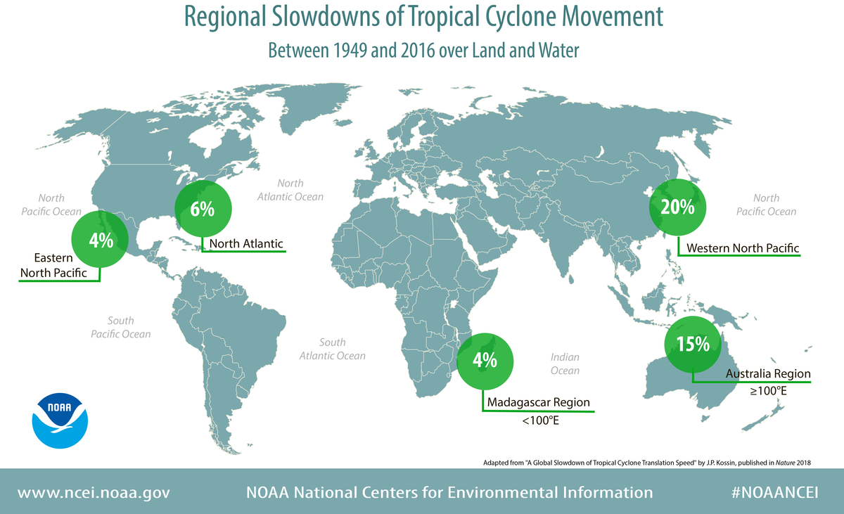 Credit: NCEI - https://www.ncei.noaa.gov/news/tropical-cyclone-slowdown
Slow movement of tropical systems may be part of the cause for heavy rain events becoming more frequent. Changes in Earth's atmosphere or climate may also contribute.
No matter the reason, it is clear that heavy rain and inland flooding from tropical systems is a threat that we will continue to have. Whether you live on the coast or hundreds of miles inland, flooding rain is just one of the many inland threats to be aware of when tropical systems threaten. It is important to be prepared before a storm is on the way.
Watch (below) what other inland risks you could face when tropical cyclones threaten.
https://www.youtube.com/watch?v=FBKLFsUUMyk&t=2s
Written for WeatherNation by meteorologist Kerrin Jeromin
Credit: NCEI - https://www.ncei.noaa.gov/news/tropical-cyclone-slowdown
Slow movement of tropical systems may be part of the cause for heavy rain events becoming more frequent. Changes in Earth's atmosphere or climate may also contribute.
No matter the reason, it is clear that heavy rain and inland flooding from tropical systems is a threat that we will continue to have. Whether you live on the coast or hundreds of miles inland, flooding rain is just one of the many inland threats to be aware of when tropical systems threaten. It is important to be prepared before a storm is on the way.
Watch (below) what other inland risks you could face when tropical cyclones threaten.
https://www.youtube.com/watch?v=FBKLFsUUMyk&t=2s
Written for WeatherNation by meteorologist Kerrin Jeromin
While not a #1 spot, Louisiana also had torrential rain fall from Barry, leaving behind nearly 2 feet of rainfall in Ragley, an unincorporated community in Beauregard Parish, Louisiana.
As Barry tops the list, now, for wettest tropical system for the state of Arkansas, that makes it the 5th state in the last 2 years to set the highest rainfall record from a tropical system. Hawaii, South Carolina, North Carolina, and Texas have also set the top record for most rainfall from a tropical system since 2017.
Texas - Hurricane Harvey (2017) : 60.58" (also a U.S. record for highest tropical rain in any state)
Hawaii - Hurricane Lane (2018) : 52.02"
North Carolina - Hurricane Florence (2018) : 35.93"
South Carolina - Hurricane Florence (2018) : 23.63"
Arkansas - Hurricane Barry (2019) : 16.59"
Record rainfall from Hurricanes Barry, Florence and Harvey has been partially attributed to the slow movement of the storms.
Coincidence? Probably not. An increase in rainfall observation sites? Likely part of the answer. A climatological trend? Some research suggests, it's possible.
According to a new study by scientist Jim Kossin of the National Centers for Environmental Information (NCEI), tropical cyclones—also sometimes referred to as hurricanes and typhoons—are taking substantially longer to move from place to place. Kossin 's research suggests that, globally, tropical cyclones slowed by 10 percent between 1949 and 2016.
According to the study, tropical cyclones have slowed in both hemispheres and in every ocean basin except the Northern Indian Ocean. But, tropical cyclones have generally slowed more in the Northern Hemisphere, where more of these storms typically occur each year. Regionally, the western North Pacific Ocean has seen the most slowing at 20 percent, followed by the region around Australia at 15 percent.
Credit: NCEI - https://www.ncei.noaa.gov/news/tropical-cyclone-slowdown
Slow movement of tropical systems may be part of the cause for heavy rain events becoming more frequent. Changes in Earth's atmosphere or climate may also contribute.
No matter the reason, it is clear that heavy rain and inland flooding from tropical systems is a threat that we will continue to have. Whether you live on the coast or hundreds of miles inland, flooding rain is just one of the many inland threats to be aware of when tropical systems threaten. It is important to be prepared before a storm is on the way.
Watch (below) what other inland risks you could face when tropical cyclones threaten.
https://www.youtube.com/watch?v=FBKLFsUUMyk&t=2s
Written for WeatherNation by meteorologist Kerrin Jeromin
All Weather News
More

Nor'Easter Riles up the Waves This Week
SETUPAn upper-level low is in the process of
20 Oct 2026 11:15 AM

Pattern Change for the West This Week
Looking ahead to this week, a low-pressure sy
20 Oct 2026 11:05 AM

Warmer Than Average: Above-Normal Temperatures Across the Central U.S. This Week
WHAT TO EXPECTA ridge of high pressure will b
20 Oct 2026 10:55 AM

Several Fires Break Out in SoCal Last Week Amid Santa Ana Wind Event
Santa Ana winds helped several fires grow qui
19 Oct 2026 1:25 PM

Another Cold Morning Before Things Warm Back Up
Across portions of the Ohio Valley through th
19 Oct 2026 10:15 AM

Severe Risk Diminishing Saturday Morning for the Northeast
Severe Storm PotentialSevere risk is decreasi
16 Oct 2026 10:20 AM