Atlantic Low Soaks East Coast
Special Stories
9 Sep 2020 2:03 PM
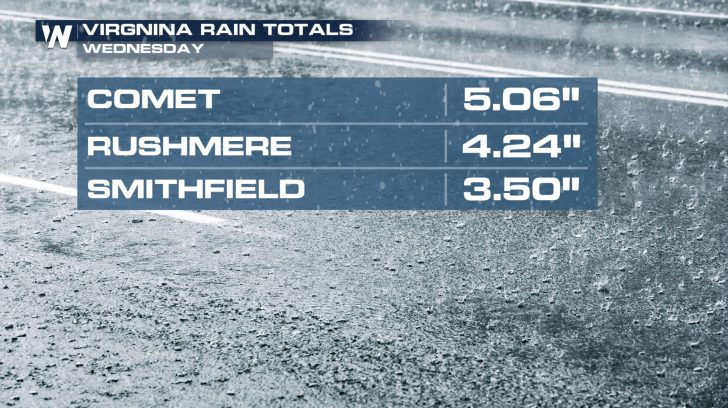
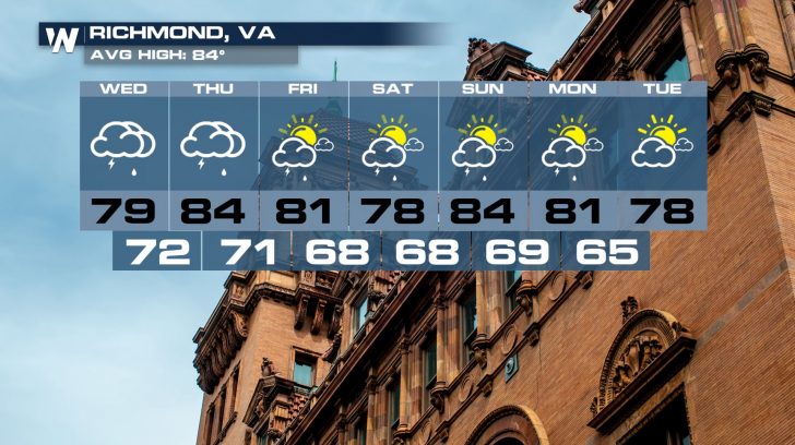
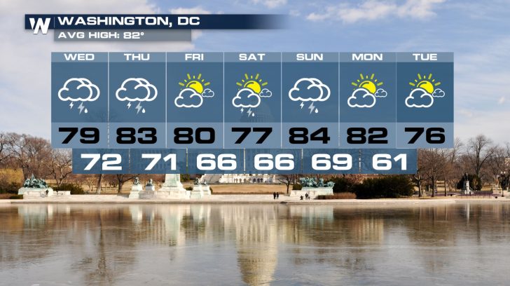
An influx of Atlantic moisture will keep parts of the East Coast quite soggy through the end of the work week. In fact, heavy downpours have already led to flash flooding and high water concerns on Wednesday morning in southeastern Virginia.
https://twitter.com/WeatherNation/status/1303770149451857922
Radar estimates of 3 to 8 inches of rain fell over the course of just a few hours in the Hampton Roads region. Unfortunately, rain totals may continue to climb.
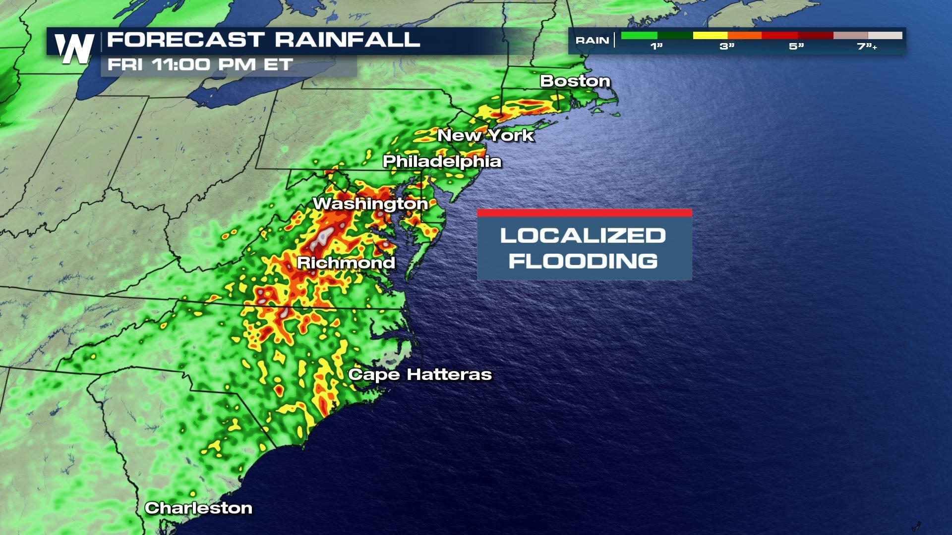
 Scattered showers and thunderstorms will continue through the evening and into the nighttime hours. The risk for excessive rainfall will continue into Thursday.
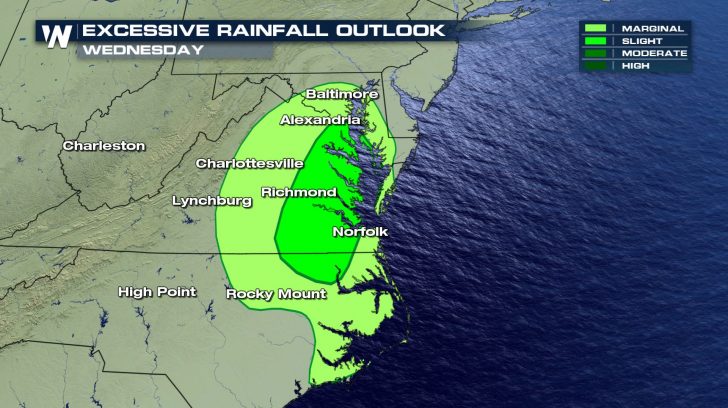
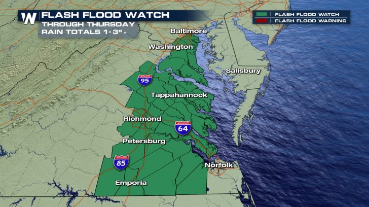
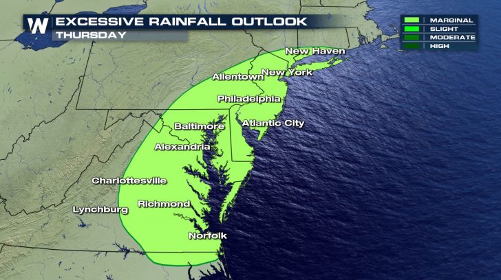 In anticipation of the heavy rainfall, the National Weather Service offices in Wakefield, Virginia and Baltimore / Washington, D.C. have issued a Flash Flood Watch through Thursday evening. This watch includes much of eastern Virginia and parts of Maryland west of the Chesapeake Bay.
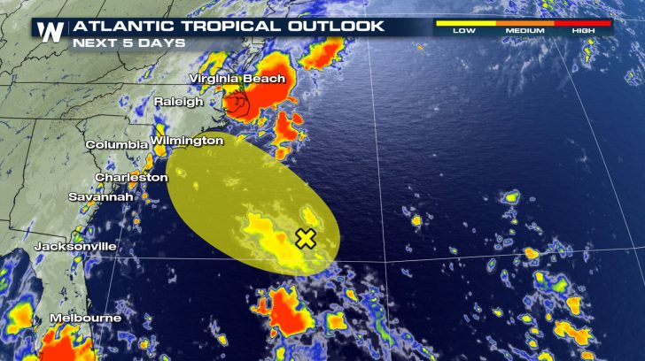
 The low pressure bringing the heavy rain to the Mid-Atlantic---located approximately 300 miles southeast of Wilmington, North Carolina---is also being monitored by the National Hurricane Center for possible tropical development. Luckily, the chance for that happening is low. However, the low is moving to the northwest at about 10 to 15 miles per hour and is expected to move inland over eastern North Carolina on Thursday afternoon.
 WeatherNation will continue to monitor this area of low pressure and all of the impacts it may bring to the East Coast.
 Be sure to follow WeatherNation on Twitter and Facebook for the latest information.
Scattered showers and thunderstorms will continue through the evening and into the nighttime hours. The risk for excessive rainfall will continue into Thursday.
In anticipation of the heavy rainfall, the National Weather Service offices in Wakefield, Virginia and Baltimore / Washington, D.C. have issued a Flash Flood Watch through Thursday evening. This watch includes much of eastern Virginia and parts of Maryland west of the Chesapeake Bay.
The low pressure bringing the heavy rain to the Mid-Atlantic---located approximately 300 miles southeast of Wilmington, North Carolina---is also being monitored by the National Hurricane Center for possible tropical development. Luckily, the chance for that happening is low. However, the low is moving to the northwest at about 10 to 15 miles per hour and is expected to move inland over eastern North Carolina on Thursday afternoon.
WeatherNation will continue to monitor this area of low pressure and all of the impacts it may bring to the East Coast.
Be sure to follow WeatherNation on Twitter and Facebook for the latest information.All Weather News
More
Severe Chances Return for the Midwest
The upcoming stretch of hot temperatures will
24 Jul 2026 8:10 PM

Southeast Flood Risk Lingers Near Stalled Front
A stalled boundary over the Carolinas will ke
24 Jul 2026 8:00 PM

Tropics: Fausto Heads to Hawaii, Bertha Breaks Apart
BerthaBertha has dissipated after moving inla
24 Jul 2026 11:50 AM

Hot & Smoky w/ a Chance of Lightning
Conditions have been really dry out west. We'
24 Jul 2026 11:15 AM

Very Hot Temperatures For the Western and Central United States
Are you over the summer heat yet? Well, more
24 Jul 2026 9:20 AM

Another Round of Storms Targets the Northeast
Tuesday brought severe weather again across p
23 Jul 2026 1:15 AM

Another Round of Severe Weather for the Upper Midwest and Great Lakes
The upper-level low train continues to keep t
21 Jul 2026 1:45 AM