Celebrating the 60th Anniversary of the World’s First Meteorological Satellite
Special Stories
6 Apr 2020 2:00 AM
[The TIROS-1 satellite. Credit: NASA]
[Edited from NOAA NESDIS] On October 4, 1957, the former Soviet Union launched Sputnik 1, the first artificial satellite to be successfully placed in orbit around Earth. The feat ushered in the Space Age and sparked a space race between the United States and its Cold War rival.
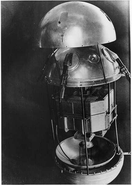 [View into Sputnik 1’s interior. Credit: NASA]
This scramble for spaceflight superiority led to the establishment of our nation’s early space programs and the launch of Explorer-1 in 1958, the first operational U.S. satellite.
The United States’ earliest attempts to see Earth’s weather from space began in the 1950s. Several experimental programs were developed and, by 1959, the first successful meteorological experiment made its way to space onboard the Explorer VII satellite.
[View into Sputnik 1’s interior. Credit: NASA]
This scramble for spaceflight superiority led to the establishment of our nation’s early space programs and the launch of Explorer-1 in 1958, the first operational U.S. satellite.
The United States’ earliest attempts to see Earth’s weather from space began in the 1950s. Several experimental programs were developed and, by 1959, the first successful meteorological experiment made its way to space onboard the Explorer VII satellite.
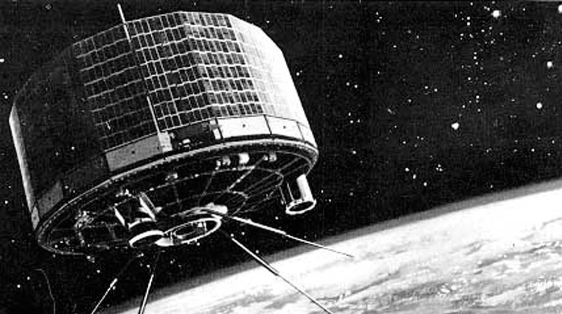
 [The TIROS-1 satellite. Credit: NASA]
60 years ago this month, on April 1, 1960, the National Aeronautics and Space Administration (NASA) launched the Television Infra-Red Observation Satellite (TIROS-1), the world’s first successful weather satellite. Weighing approximately 270 pounds and carrying two TV cameras and two video recorders, the satellite provided weather forecasters their first ever view of cloud formations as they developed around the globe.
TIROS-1 orbited 450 miles above Earth and communicated with two command and data acquisition stations. When the satellite was in range of a station and the data was read out, the images (up to 32 could be recorded for playback) were recorded on 35-mm film for making prints.
[The TIROS-1 satellite. Credit: NASA]
60 years ago this month, on April 1, 1960, the National Aeronautics and Space Administration (NASA) launched the Television Infra-Red Observation Satellite (TIROS-1), the world’s first successful weather satellite. Weighing approximately 270 pounds and carrying two TV cameras and two video recorders, the satellite provided weather forecasters their first ever view of cloud formations as they developed around the globe.
TIROS-1 orbited 450 miles above Earth and communicated with two command and data acquisition stations. When the satellite was in range of a station and the data was read out, the images (up to 32 could be recorded for playback) were recorded on 35-mm film for making prints.
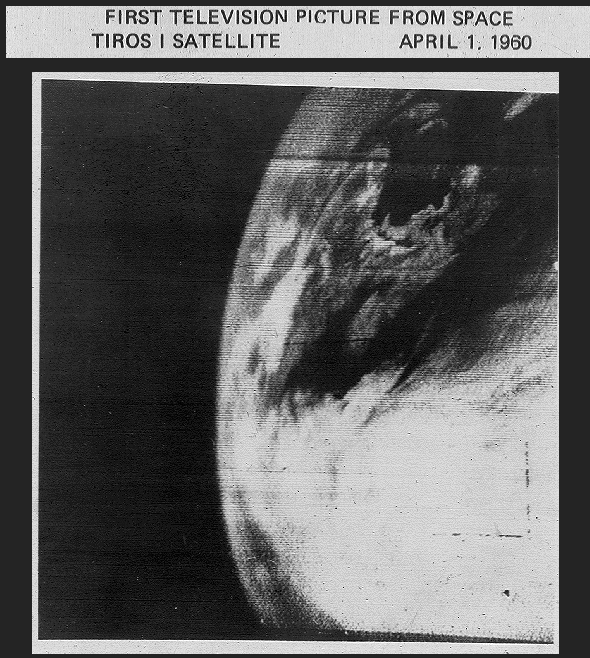 [One of the first images from the TIROS-1 satellite, April 1, 1960. Credit: NASA]
Although the satellite operated for only 78 days, TIROS-1 sent back 19,389 usable pictures, proving the worth of weather observing satellites to the world and opening the door for the weather systems of the future. The first image from the satellite was a fuzzy picture of thick bands and clusters of clouds over the United States. An image captured a few days later revealed a typhoon about a 1,000 miles east of Australia.
Over the next several years the scientists and technologists at NASA and the Environmental Science Services Administration (ESSA) designed, built, and launched multiple TIROS missions, each carrying increasingly advanced technology. In 1970, 10 years after the launch of TIROS-1, NOAA was established in recognition of the value and importance of a meteorological agency supported by space-based observation.
[One of the first images from the TIROS-1 satellite, April 1, 1960. Credit: NASA]
Although the satellite operated for only 78 days, TIROS-1 sent back 19,389 usable pictures, proving the worth of weather observing satellites to the world and opening the door for the weather systems of the future. The first image from the satellite was a fuzzy picture of thick bands and clusters of clouds over the United States. An image captured a few days later revealed a typhoon about a 1,000 miles east of Australia.
Over the next several years the scientists and technologists at NASA and the Environmental Science Services Administration (ESSA) designed, built, and launched multiple TIROS missions, each carrying increasingly advanced technology. In 1970, 10 years after the launch of TIROS-1, NOAA was established in recognition of the value and importance of a meteorological agency supported by space-based observation.
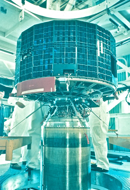
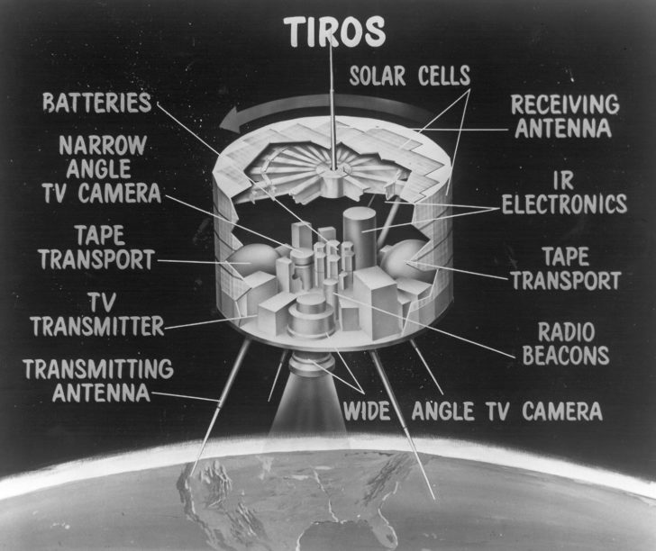 [An artist rendering of the instruments aboard the TIROS-1 satellite. Credit: NASA]
Inheriting the recently launched Improved TIROS Operational System (ITOS-1) from their predecessor the ESSA, NOAA continued to advance the operational applications of weather satellites. As the capabilities of these satellites improved, they would evolve into NOAA’s current polar-orbiting satellites, the backbone of the global overserving system.
Soon after the launches of the ITOS satellites, the Synchronous Meteorological Satellite (SMS-1) became the first prototype geostationary satellite in 1974. Just a year later, in 1975, the SMS series of satellites would become the first operational Geostationary Operational Environmental Satellites (GOES) in orbit with the launch of GOES-1.
http://www.facebook.com/NOAALibraries/videos/867605653378982/
Today, with the next generation of environmental observation satellites in orbit—GOES-R and JPSS—we are continuously improving our weather monitoring and prediction with state-of-the-art data and imagery. These satellites are also significantly enhancing our understanding of the Earth as a whole system.
[An artist rendering of the instruments aboard the TIROS-1 satellite. Credit: NASA]
Inheriting the recently launched Improved TIROS Operational System (ITOS-1) from their predecessor the ESSA, NOAA continued to advance the operational applications of weather satellites. As the capabilities of these satellites improved, they would evolve into NOAA’s current polar-orbiting satellites, the backbone of the global overserving system.
Soon after the launches of the ITOS satellites, the Synchronous Meteorological Satellite (SMS-1) became the first prototype geostationary satellite in 1974. Just a year later, in 1975, the SMS series of satellites would become the first operational Geostationary Operational Environmental Satellites (GOES) in orbit with the launch of GOES-1.
http://www.facebook.com/NOAALibraries/videos/867605653378982/
Today, with the next generation of environmental observation satellites in orbit—GOES-R and JPSS—we are continuously improving our weather monitoring and prediction with state-of-the-art data and imagery. These satellites are also significantly enhancing our understanding of the Earth as a whole system.
[View into Sputnik 1’s interior. Credit: NASA]
This scramble for spaceflight superiority led to the establishment of our nation’s early space programs and the launch of Explorer-1 in 1958, the first operational U.S. satellite.
The United States’ earliest attempts to see Earth’s weather from space began in the 1950s. Several experimental programs were developed and, by 1959, the first successful meteorological experiment made its way to space onboard the Explorer VII satellite.
[The TIROS-1 satellite. Credit: NASA]
60 years ago this month, on April 1, 1960, the National Aeronautics and Space Administration (NASA) launched the Television Infra-Red Observation Satellite (TIROS-1), the world’s first successful weather satellite. Weighing approximately 270 pounds and carrying two TV cameras and two video recorders, the satellite provided weather forecasters their first ever view of cloud formations as they developed around the globe.
TIROS-1 orbited 450 miles above Earth and communicated with two command and data acquisition stations. When the satellite was in range of a station and the data was read out, the images (up to 32 could be recorded for playback) were recorded on 35-mm film for making prints.
[One of the first images from the TIROS-1 satellite, April 1, 1960. Credit: NASA]
Although the satellite operated for only 78 days, TIROS-1 sent back 19,389 usable pictures, proving the worth of weather observing satellites to the world and opening the door for the weather systems of the future. The first image from the satellite was a fuzzy picture of thick bands and clusters of clouds over the United States. An image captured a few days later revealed a typhoon about a 1,000 miles east of Australia.
Over the next several years the scientists and technologists at NASA and the Environmental Science Services Administration (ESSA) designed, built, and launched multiple TIROS missions, each carrying increasingly advanced technology. In 1970, 10 years after the launch of TIROS-1, NOAA was established in recognition of the value and importance of a meteorological agency supported by space-based observation.
[An artist rendering of the instruments aboard the TIROS-1 satellite. Credit: NASA]
Inheriting the recently launched Improved TIROS Operational System (ITOS-1) from their predecessor the ESSA, NOAA continued to advance the operational applications of weather satellites. As the capabilities of these satellites improved, they would evolve into NOAA’s current polar-orbiting satellites, the backbone of the global overserving system.
Soon after the launches of the ITOS satellites, the Synchronous Meteorological Satellite (SMS-1) became the first prototype geostationary satellite in 1974. Just a year later, in 1975, the SMS series of satellites would become the first operational Geostationary Operational Environmental Satellites (GOES) in orbit with the launch of GOES-1.
http://www.facebook.com/NOAALibraries/videos/867605653378982/
Today, with the next generation of environmental observation satellites in orbit—GOES-R and JPSS—we are continuously improving our weather monitoring and prediction with state-of-the-art data and imagery. These satellites are also significantly enhancing our understanding of the Earth as a whole system. All Weather News
More
Wildfire Outbreak in the Pacific Northwest
Conditions have been incredibly dry out west.
2 Aug 2026 1:30 PM

After Reaching Category 5, Genevieve Weakens in the Pacific
PacificGenevieve formed on last Friday south
2 Aug 2026 1:25 PM

More Storms for the East Sunday and Monday
A low-pressure system crashing through the Mi
2 Aug 2026 1:25 PM


Flooding, Severe Storms Target the Midwest Again
After an active week of storms across the nor
1 Aug 2026 1:40 AM

Flooding Risk Increases as Heavy Rain Targets the Tri-State Area
Tuesday, heavy rainfall moved across the Nort
30 Jul 2026 12:25 AM

Severe Weather: Energy From the Midwest Now in the Southeast
UPPER MIDWEST - Through Monday, dangerous tor
29 Jul 2026 10:30 PM