A Closer Look at the Wildfires in Oklahoma from this Month
Special Stories
25 Apr 2018 10:03 AM
From NOAA by Tom Di Liberto
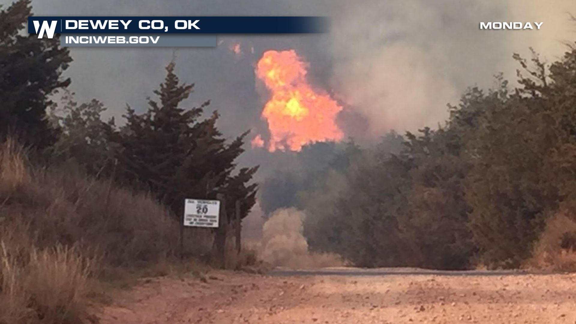
Incredibly dry and windy conditions across western Oklahoma led to the rapid spread of numerous wildfires this month. The National Weather Service noted that conditions have not been so favorable for the spread of wildfires in this region in the past ten years, according to the Associated Press.
As of this morning, there are two large wildfires that have burned this month in Oklahoma. The largest, the Rhea fire, is 99% contained and has already burned through almost 290,000 acres of land. For reference, that is almost the size of the city of Los Angeles and is larger than the infamous Thomas wildfire in California, which set the record late last year for largest in California state history.
The Rhea fire started on April 12 and has taken advantage of favorable atmospheric conditions to explode in size over the two weeks. Particularly, on April 17, strong winds fanned the flames, helping the wildfire advance five to eight miles. The fire has already destroyed around 50 homes.
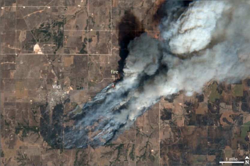 [Satellite image taken of central Oklahoma on April 17 by the Sentinel-2 satellite from the European Space Agency. The Rhea fire, taking advantage of dry grasses and strong winds, burned almost 290,000 acres of land near the town of Vici, Oklahoma during the middle of April.]
Close by, the 34 Complex fire has burned through over 60,000 acres of land and is now 100% contained. The Oklahoma Forest Services are actively managing the situation, providing ongoing updates through their webpage and social media.
This year, following a drier than average winter led to worsening drought conditions across much of western Oklahoma. Prairie grasses were already dried out and primed to burn. Temperatures leading up to the wildfire outbreaks were also warmer than average, and exceptionally dry air lingered overhead. But there was still one ingredient missing, wind.
[Satellite image taken of central Oklahoma on April 17 by the Sentinel-2 satellite from the European Space Agency. The Rhea fire, taking advantage of dry grasses and strong winds, burned almost 290,000 acres of land near the town of Vici, Oklahoma during the middle of April.]
Close by, the 34 Complex fire has burned through over 60,000 acres of land and is now 100% contained. The Oklahoma Forest Services are actively managing the situation, providing ongoing updates through their webpage and social media.
This year, following a drier than average winter led to worsening drought conditions across much of western Oklahoma. Prairie grasses were already dried out and primed to burn. Temperatures leading up to the wildfire outbreaks were also warmer than average, and exceptionally dry air lingered overhead. But there was still one ingredient missing, wind.
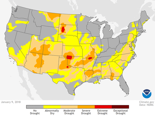 [U.S. drought conditions on January 8, February 13, March 13, and April 17, color coded from yellow (abnormally dry) to dark red (exceptional drought). NOAA Climate animation, based on data from the US Drought Monitor project.]
During spring across the Plains, it’s not uncommon to have strong winds—associated with sprawling storm systems that stretch thousands of miles—that are not necessarily accompanied by rain. These enhanced winds can help a spark become conflagration in a heartbeat, allowing flames to jump roads, swallowing up all of the dried-out grasses along the way.
On the days around when the Rhea Fire exploded, the winds were howling, gusting to over 40 mph. Not surprisingly with this many alarm bells going off, scientists with the NOAA/NWS Storm Prediction Center issued an extremely critical fire weather outlook for multiple days during the middle of April. And sadly, they were right to do so.
[U.S. drought conditions on January 8, February 13, March 13, and April 17, color coded from yellow (abnormally dry) to dark red (exceptional drought). NOAA Climate animation, based on data from the US Drought Monitor project.]
During spring across the Plains, it’s not uncommon to have strong winds—associated with sprawling storm systems that stretch thousands of miles—that are not necessarily accompanied by rain. These enhanced winds can help a spark become conflagration in a heartbeat, allowing flames to jump roads, swallowing up all of the dried-out grasses along the way.
On the days around when the Rhea Fire exploded, the winds were howling, gusting to over 40 mph. Not surprisingly with this many alarm bells going off, scientists with the NOAA/NWS Storm Prediction Center issued an extremely critical fire weather outlook for multiple days during the middle of April. And sadly, they were right to do so.
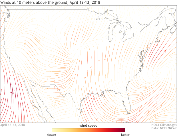 [Average winds measured at 10 meters above the ground from April 12-13, 2018 for the United States. Strong southerly winds associated with a sprawling storm system across the middle of the country helped fan the flames of wildfires across western Oklahoma during the middle of April. NOAA Climate image using data from NCEP/NCAR Reanalysis.]
Wildfires in the spring across the Plains happen and are all too common. In fact, this was covered in a story just last year about massive wildfires in Oklahoma, Kansas, and Texas. In the Climate Science Special Report issued as a part of the fourth National Climate Assessment, scientists note that the number of large fires has increased over the western United States from 1984 to 2011. This includes an uptick in very large fires across the southern plains.
Edited for WeatherNation by Meteorologist Mace Michaels
[Average winds measured at 10 meters above the ground from April 12-13, 2018 for the United States. Strong southerly winds associated with a sprawling storm system across the middle of the country helped fan the flames of wildfires across western Oklahoma during the middle of April. NOAA Climate image using data from NCEP/NCAR Reanalysis.]
Wildfires in the spring across the Plains happen and are all too common. In fact, this was covered in a story just last year about massive wildfires in Oklahoma, Kansas, and Texas. In the Climate Science Special Report issued as a part of the fourth National Climate Assessment, scientists note that the number of large fires has increased over the western United States from 1984 to 2011. This includes an uptick in very large fires across the southern plains.
Edited for WeatherNation by Meteorologist Mace Michaels
[Satellite image taken of central Oklahoma on April 17 by the Sentinel-2 satellite from the European Space Agency. The Rhea fire, taking advantage of dry grasses and strong winds, burned almost 290,000 acres of land near the town of Vici, Oklahoma during the middle of April.]
Close by, the 34 Complex fire has burned through over 60,000 acres of land and is now 100% contained. The Oklahoma Forest Services are actively managing the situation, providing ongoing updates through their webpage and social media.
This year, following a drier than average winter led to worsening drought conditions across much of western Oklahoma. Prairie grasses were already dried out and primed to burn. Temperatures leading up to the wildfire outbreaks were also warmer than average, and exceptionally dry air lingered overhead. But there was still one ingredient missing, wind.
[U.S. drought conditions on January 8, February 13, March 13, and April 17, color coded from yellow (abnormally dry) to dark red (exceptional drought). NOAA Climate animation, based on data from the US Drought Monitor project.]
During spring across the Plains, it’s not uncommon to have strong winds—associated with sprawling storm systems that stretch thousands of miles—that are not necessarily accompanied by rain. These enhanced winds can help a spark become conflagration in a heartbeat, allowing flames to jump roads, swallowing up all of the dried-out grasses along the way.
On the days around when the Rhea Fire exploded, the winds were howling, gusting to over 40 mph. Not surprisingly with this many alarm bells going off, scientists with the NOAA/NWS Storm Prediction Center issued an extremely critical fire weather outlook for multiple days during the middle of April. And sadly, they were right to do so.
[Average winds measured at 10 meters above the ground from April 12-13, 2018 for the United States. Strong southerly winds associated with a sprawling storm system across the middle of the country helped fan the flames of wildfires across western Oklahoma during the middle of April. NOAA Climate image using data from NCEP/NCAR Reanalysis.]
Wildfires in the spring across the Plains happen and are all too common. In fact, this was covered in a story just last year about massive wildfires in Oklahoma, Kansas, and Texas. In the Climate Science Special Report issued as a part of the fourth National Climate Assessment, scientists note that the number of large fires has increased over the western United States from 1984 to 2011. This includes an uptick in very large fires across the southern plains.
Edited for WeatherNation by Meteorologist Mace MichaelsAll Weather News
More
More Storms for the East Through Monday
A low-pressure system that moved through the
2 Aug 2026 10:40 PM

Wildfire Outbreak in the Pacific Northwest
SPOKANE, WA - On Saturday, August 1st, the Ol
2 Aug 2026 10:35 PM


After Reaching Category 5, Genevieve Weakens in the Pacific
PacificGenevieve formed on last Friday south
2 Aug 2026 6:25 PM

Flooding, Severe Storms Target the Midwest Again
After an active week of storms across the nor
1 Aug 2026 1:40 AM

Flooding Risk Increases as Heavy Rain Targets the Tri-State Area
Tuesday, heavy rainfall moved across the Nort
30 Jul 2026 12:25 AM

Severe Weather: Energy From the Midwest Now in the Southeast
UPPER MIDWEST - Through Monday, dangerous tor
29 Jul 2026 10:30 PM