A Cold Night Ahead For The Midwest
Special Stories
28 Apr 2018 1:26 PM
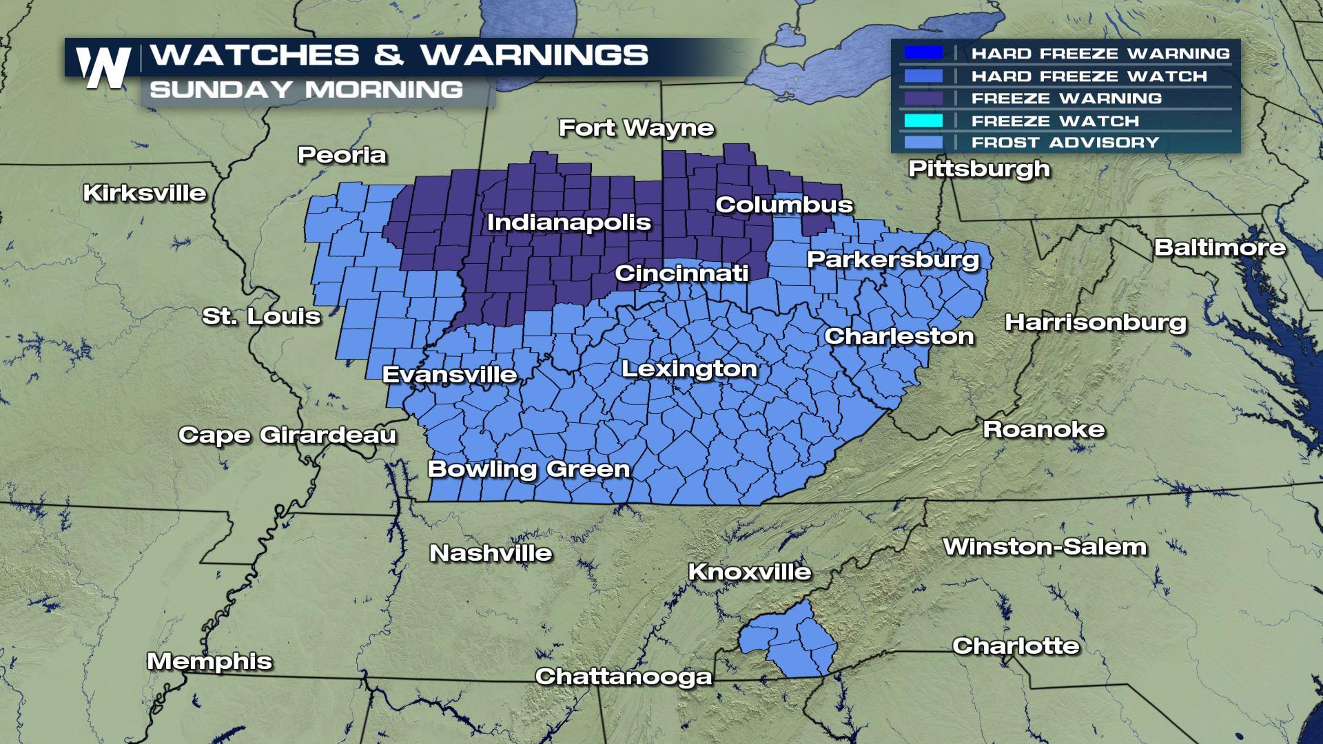
It looks like a couple of cold nights are in store for parts of the South and the Midwest. The National Weather Service has issued Freeze Warnings and Frost Advisories for Saturday night into Sunday morning. And it's possible they could be issued again for Sunday night into Monday morning.
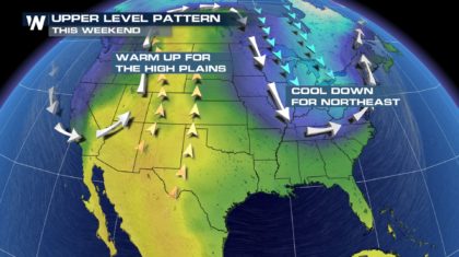
 Why the blast of cold air in late April? The main reason has to do with an undulating jet stream. Springtime often brings very changeable weather, and that includes big temperature swings. The jet stream moves north and south in wave-like patterns, causing these temperature changes. When the jet moves to the north, it allows warm air to move in from the south. We can see this happening on the map below. There's warm air moving northward in the center of the country this weekend. This is called a "Ridge" in the jet stream. On the flip side, when the jet digs southward, colder air pours in behind it. This is called a "trough" in the jet stream. This is happening this weekend in the Midwest and the northeast.
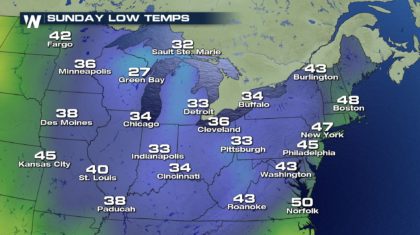
 Check out the low temps on Sunday morning. Green Bay will drop to 27 degrees. Temps will fall into the 30's from Chicago to Buffalo, down to Cincinnati and Pittsburgh. Those are pretty chilly temps for late April.
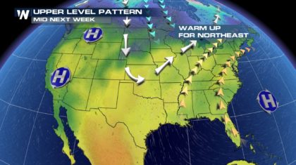
 Early next week, the jet stream will form a trough over the central U.S. and ridge will form over the Midwest and the northeast. This will essentially reverse the temperature profiles from where they are this weekend. Temps will quickly rise in places that are under Freeze Warnings tonight.
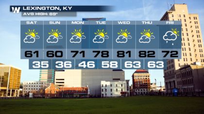
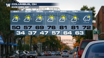
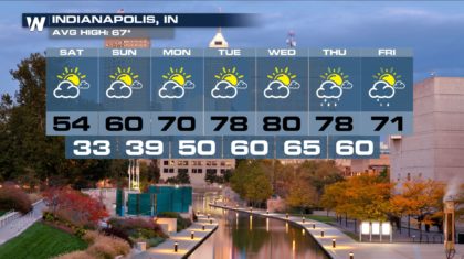
 Take a look at some of the extended forecasts below. Compare the temperatures, both highs and lows, between this weekend, and Tuesday of next week. You'll find that much warmer temperatures are on the way. So if you're in a cold place right now, hang in there, warmer temps are coming!
 For WeatherNation: Meteorologist Matt Monroe
Why the blast of cold air in late April? The main reason has to do with an undulating jet stream. Springtime often brings very changeable weather, and that includes big temperature swings. The jet stream moves north and south in wave-like patterns, causing these temperature changes. When the jet moves to the north, it allows warm air to move in from the south. We can see this happening on the map below. There's warm air moving northward in the center of the country this weekend. This is called a "Ridge" in the jet stream. On the flip side, when the jet digs southward, colder air pours in behind it. This is called a "trough" in the jet stream. This is happening this weekend in the Midwest and the northeast.
Check out the low temps on Sunday morning. Green Bay will drop to 27 degrees. Temps will fall into the 30's from Chicago to Buffalo, down to Cincinnati and Pittsburgh. Those are pretty chilly temps for late April.
Early next week, the jet stream will form a trough over the central U.S. and ridge will form over the Midwest and the northeast. This will essentially reverse the temperature profiles from where they are this weekend. Temps will quickly rise in places that are under Freeze Warnings tonight.
Take a look at some of the extended forecasts below. Compare the temperatures, both highs and lows, between this weekend, and Tuesday of next week. You'll find that much warmer temperatures are on the way. So if you're in a cold place right now, hang in there, warmer temps are coming!
For WeatherNation: Meteorologist Matt MonroeAll Weather News
More
Flooding Risk Increases as Heavy Rain Targets the Tri-State Area
Tuesday, heavy rainfall moved across the Nort
30 Jul 2026 12:25 AM


Genevieve Down to a Category 2 Hurricane
PacificFausto is now a post-tropical cyclone.
30 Jul 2026 12:00 AM

Severe Weather: Energy From the Midwest Now in the Southeast
UPPER MIDWEST - Through Monday, dangerous tor
29 Jul 2026 10:30 PM


Southeast Flood Risk Lingers Near Stalled Front
A stalled boundary over the Southeast will ke
25 Jul 2026 10:55 AM

Another Round of Storms Targets the Northeast
Tuesday brought severe weather again across p
23 Jul 2026 1:15 AM