Colorado Snow Pack & Reservoir Storage in Good Shape Heading into April

Special Stories
25 Mar 2020 6:59 AM
Snowpack in Colorado's southern mountains got a much needed boost last week when a moisture packed storm system slammed the region and even brought blizzard conditions to portions of Colorado's Front Range.
[embed]https://twitter.com/WeatherNation/status/1240850553246277640?ref_src=twsrc%5Etfw%7Ctwcamp%5Etweetembed%7Ctwterm%5E1240850553246277640&ref_url=https%3A%2F%2Fpublish.twitter.com%2F%3Fquery%3Dhttps%253A%252F%252Ftwitter.com%252FWeatherNation%252Fstatus%252F1240850553246277640%26widget%3DTweet[/embed]
Snowpack is vital to the region and not just for recreation, but also for water supply, habitat, and tourism.
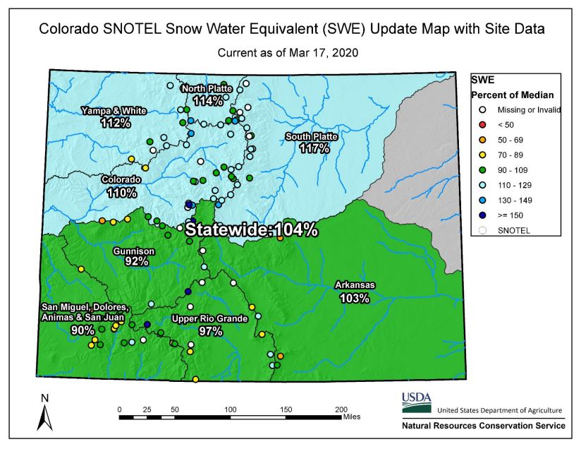 February was wetter than average in the North and Central mountains, but was a bit drier farther south. Combined with a dry and warmer start to the month of March, snowpack was lacking across the Southwestern mountains.
Streamflow forecasts were lacking as a result in the state water conservation boards latest report, some lower than 70% of normal.
February was wetter than average in the North and Central mountains, but was a bit drier farther south. Combined with a dry and warmer start to the month of March, snowpack was lacking across the Southwestern mountains.
Streamflow forecasts were lacking as a result in the state water conservation boards latest report, some lower than 70% of normal.
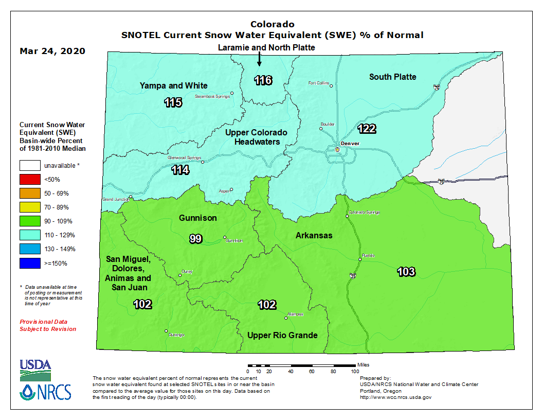 Thanks to last week's storm, the latest map released Tuesday by the U.S. Department of Agriculture shows the snow water equivalent across the state is now above average everywhere, except for the Gunnison River Valley which comes in a mere one percent shy.
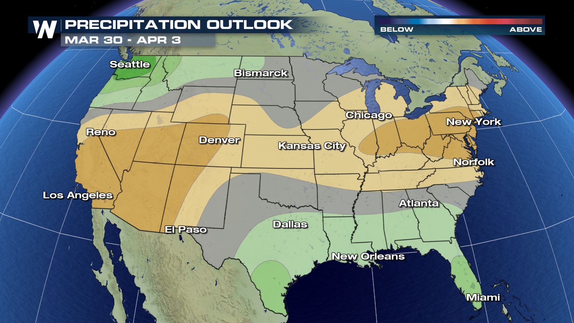
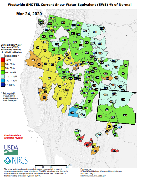 While Nevada, California, and Oregon remain a bit behind on snowpack, the rest of the West is looking to head into April in good shape. Unfortunately, the Climate Prediction Center's latest outlook doesn't favor the wet pattern across the Southwest to continue.
February was wetter than average in the North and Central mountains, but was a bit drier farther south. Combined with a dry and warmer start to the month of March, snowpack was lacking across the Southwestern mountains.
Streamflow forecasts were lacking as a result in the state water conservation boards latest report, some lower than 70% of normal.
Thanks to last week's storm, the latest map released Tuesday by the U.S. Department of Agriculture shows the snow water equivalent across the state is now above average everywhere, except for the Gunnison River Valley which comes in a mere one percent shy.
While Nevada, California, and Oregon remain a bit behind on snowpack, the rest of the West is looking to head into April in good shape. Unfortunately, the Climate Prediction Center's latest outlook doesn't favor the wet pattern across the Southwest to continue.
All Weather News
More

More Storms for the East Through Monday
A low-pressure system that moved through the
3 Aug 2026 12:20 PM


After Reaching Category 5, Genevieve Weakens in the Pacific
PacificGenevieve formed last Friday south of
3 Aug 2026 12:30 AM

Flooding, Severe Storms Target the Midwest Again
After an active week of storms across the nor
1 Aug 2026 1:40 AM

Flooding Risk Increases as Heavy Rain Targets the Tri-State Area
Tuesday, heavy rainfall moved across the Nort
30 Jul 2026 12:25 AM