CSU Releases Updated Atlantic Season Outlook
Special Stories
5 Aug 2020 8:30 PM
Meteorologists and research scientists at Colorado State University (CSU) released a second update to their well-respected hurricane season outlook. Dr. Phil Klotzbach and the Tropical Meteorology Project at CSU were among the first to issue an outlook in April, with a previous update in early June. The season was forecast to be above average and is living up to that prediction. Arthur formed in mid-May before the season started. Bertha quickly formed and made landfall off the Carolina coast. Cristobal became the earliest "C" named storm in recorded history. Dolly and Edouard gratefully stayed in the open Atlantic with no impacts to land. Because of the five named Atlantic storms, CSU increased their number of storms forecast.
The tropics remained active with another four named storms Fay, Gonzalo, Hanna and now Isaias. This requires another reevaluation of the forecast and the update is below.
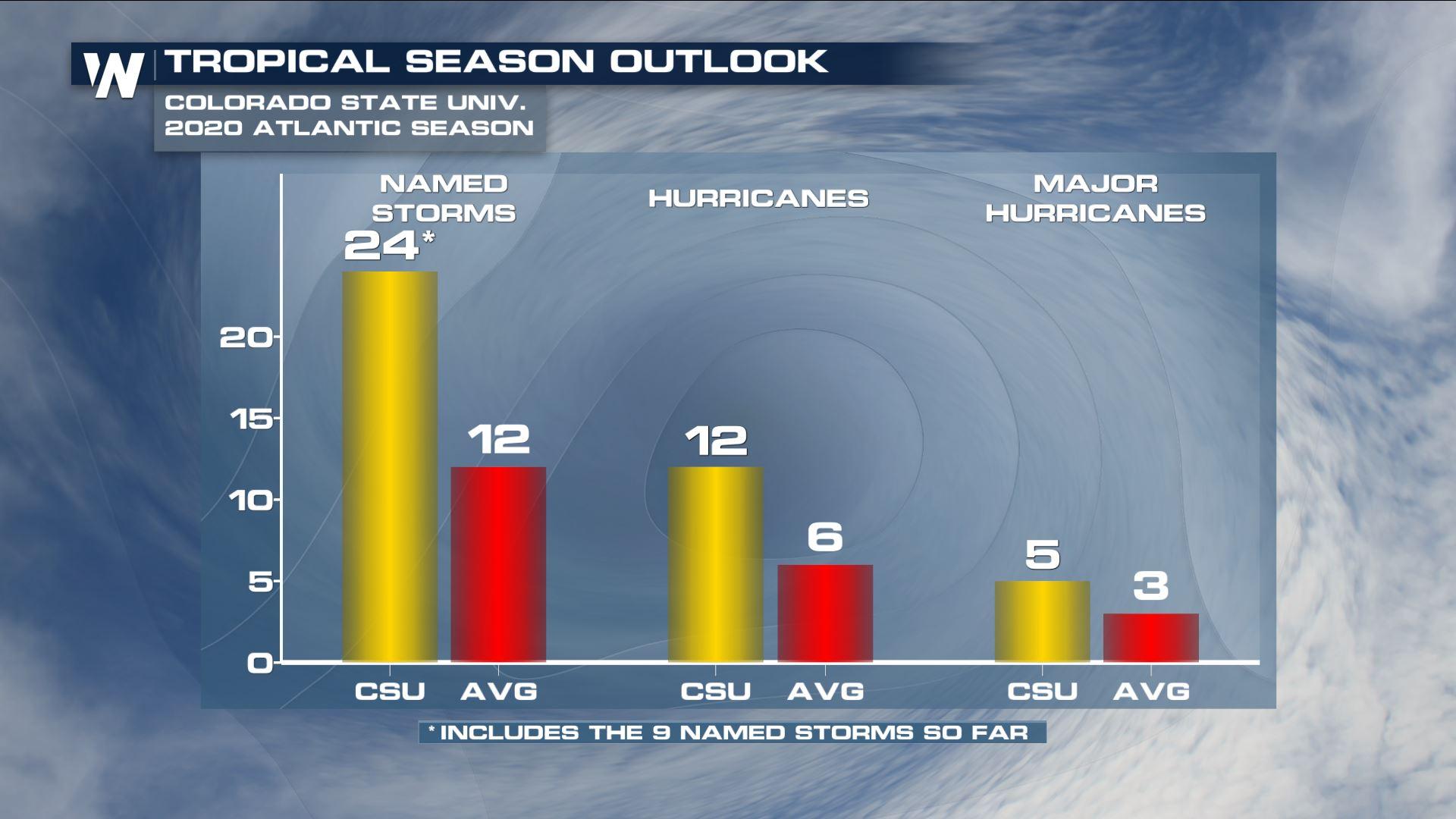
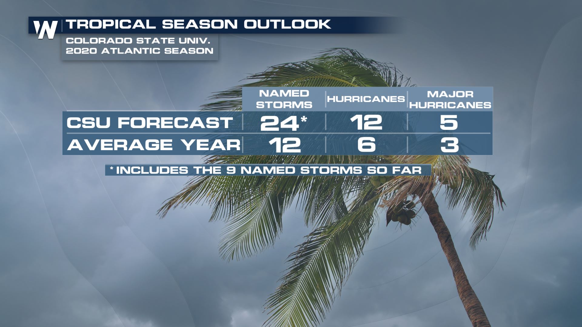 Their initial prediction had 16 named storms, updated in June 2020 to 19. The first update to the forecast upped those numbers to 20 named storms, 9 of which becoming hurricanes and 4 of those becoming major hurricanes.
The August update now bumps the total number of named storms to 24* with 12 hurricanes and 5 of those becoming major hurricanes. This forecast also includes all of the named storms so far.
Their initial prediction had 16 named storms, updated in June 2020 to 19. The first update to the forecast upped those numbers to 20 named storms, 9 of which becoming hurricanes and 4 of those becoming major hurricanes.
The August update now bumps the total number of named storms to 24* with 12 hurricanes and 5 of those becoming major hurricanes. This forecast also includes all of the named storms so far.
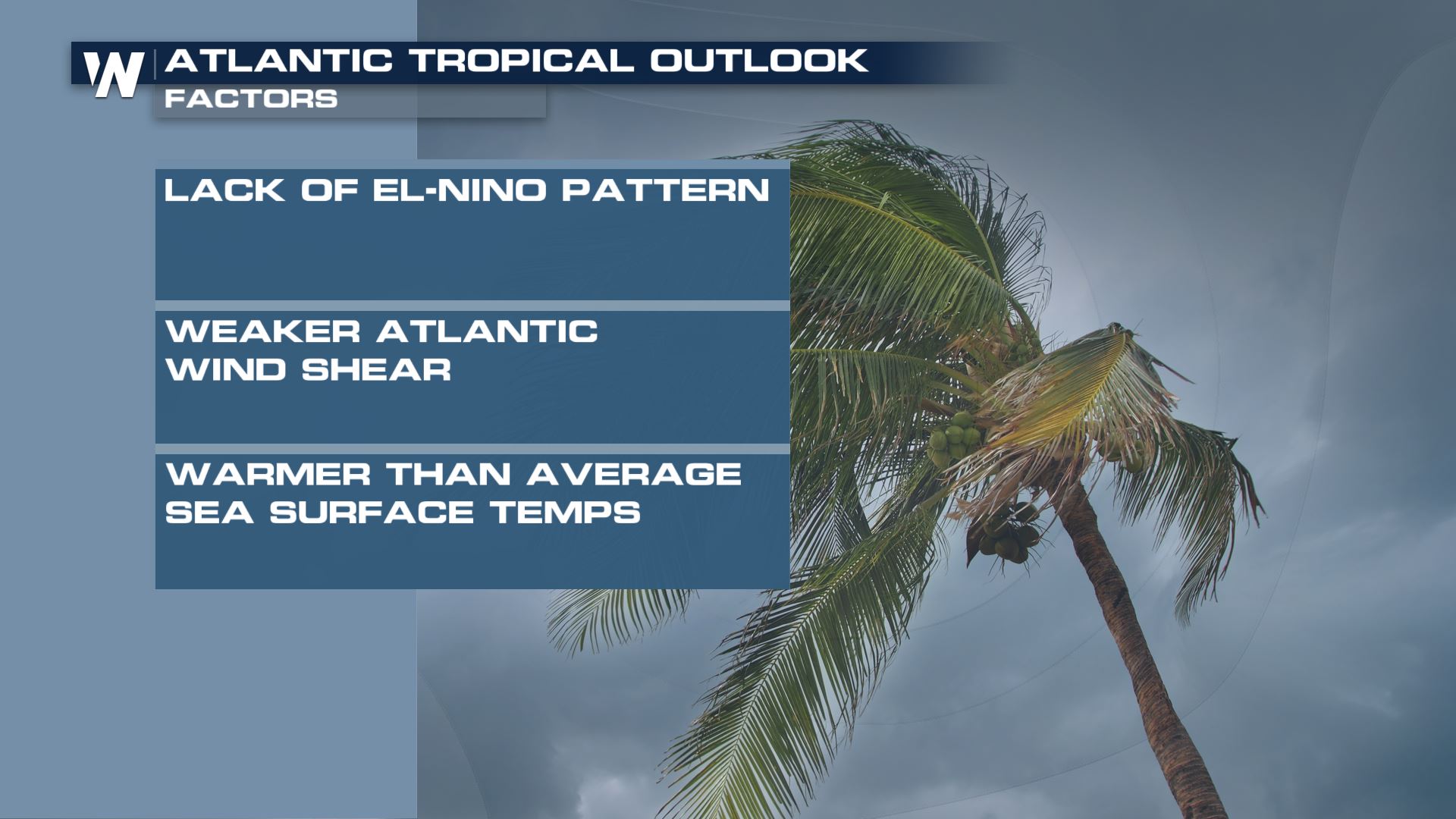
“One of the factors we are looking at for this year is that we do not anticipate El Niño conditions going on,” explains Dr. Phil Klotzbach, CSU Research Scientist.
An El Niño would mean warmer-than-normal water in the central and eastern [tropical] Pacific Ocean. That tends to create more wind shear to tear apart hurricanes in the Atlantic. Because El Niño is not expected to limit development, more hurricanes may form.
Another factor this year is warm water in the Atlantic Basin.
“Warmer-than-normal water temperatures [in the Atlantic] are associated with a more unstable atmosphere and also more moisture. The combination provides more fuel for the storms and that in turn tends to lead to more active hurricane seasons,” says Dr. Klotzbach.
https://twitter.com/philklotzbach/status/1291028688838901760
https://www.youtube.com/watch?v=9mKwg1oj8UM
CSU has chosen six hurricane forecasts from the past to analyze and corroborate the current forecast. Those [analog] years are 1966, 1995, 2003, 2008, 2010 and 2017 for the August seasonal update.
“All of these years had above-average Atlantic hurricane activity and were generally characterized by cool neutral ENSO or LaNina conditions and warm tropical Atlantic.” explains Dr. Klotzbach.
This hurricane outlook covers the entire Atlantic basin from a standpoint of below or above average activity. However, it does not guarantee you will [or will not] experience a tropical cyclone.
“Regardless of the hurricane forecast, we can’t say when or where storms are going to strike. So you need to be prepared for any hurricane season because it just takes that one hurricane making landfall near where you live to make it an active season for you,” advises Dr. Klotzbach.
It is never too late to get your hurricane plan and kits ready. NOAA will be releasing an update to their forecast Thursday August 6th. Not surprisingly, they also expect an above average season.
Their initial prediction had 16 named storms, updated in June 2020 to 19. The first update to the forecast upped those numbers to 20 named storms, 9 of which becoming hurricanes and 4 of those becoming major hurricanes.
The August update now bumps the total number of named storms to 24* with 12 hurricanes and 5 of those becoming major hurricanes. This forecast also includes all of the named storms so far.
 Contributing factors into the 2020 Atlantic Tropical Outlook, courtesy CSU.
“One of the factors we are looking at for this year is that we do not anticipate El Niño conditions going on,” explains Dr. Phil Klotzbach, CSU Research Scientist.
An El Niño would mean warmer-than-normal water in the central and eastern [tropical] Pacific Ocean. That tends to create more wind shear to tear apart hurricanes in the Atlantic. Because El Niño is not expected to limit development, more hurricanes may form.
Another factor this year is warm water in the Atlantic Basin.
“Warmer-than-normal water temperatures [in the Atlantic] are associated with a more unstable atmosphere and also more moisture. The combination provides more fuel for the storms and that in turn tends to lead to more active hurricane seasons,” says Dr. Klotzbach.
https://twitter.com/philklotzbach/status/1291028688838901760
https://www.youtube.com/watch?v=9mKwg1oj8UM
CSU has chosen six hurricane forecasts from the past to analyze and corroborate the current forecast. Those [analog] years are 1966, 1995, 2003, 2008, 2010 and 2017 for the August seasonal update.
“All of these years had above-average Atlantic hurricane activity and were generally characterized by cool neutral ENSO or LaNina conditions and warm tropical Atlantic.” explains Dr. Klotzbach.
This hurricane outlook covers the entire Atlantic basin from a standpoint of below or above average activity. However, it does not guarantee you will [or will not] experience a tropical cyclone.
“Regardless of the hurricane forecast, we can’t say when or where storms are going to strike. So you need to be prepared for any hurricane season because it just takes that one hurricane making landfall near where you live to make it an active season for you,” advises Dr. Klotzbach.
It is never too late to get your hurricane plan and kits ready. NOAA will be releasing an update to their forecast Thursday August 6th. Not surprisingly, they also expect an above average season.All Weather News
More
Flooding, Severe Storms Target the Midwest Again
After an active week of storms across the nor
31 Jul 2026 4:15 PM


After Reaching Category 5, Genevieve Weakens in the Pacific
PacificFausto is now a post-tropical cyclone.
31 Jul 2026 1:30 AM

Flooding Risk Increases as Heavy Rain Targets the Tri-State Area
Tuesday, heavy rainfall moved across the Nort
30 Jul 2026 12:25 AM

Severe Weather: Energy From the Midwest Now in the Southeast
UPPER MIDWEST - Through Monday, dangerous tor
29 Jul 2026 10:30 PM