Drones: Helping NOAA from Hurricanes to Red Tide
Special Stories
12 Nov 2019 2:31 AM
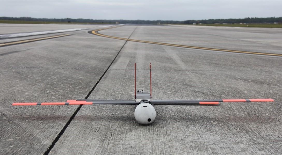
[NOAA Coyote drone in Avon Park, FL. From NOAA]
[NOAA] Collecting data is a critical part of doing research. But it can be a lengthy, challenging process, and in some cases — especially when dealing with severe weather or treacherous terrain — it can pose a danger to scientists.
Enter NOAA’s Unmanned Aircraft Systems (UAS) program, which provides funding for research aimed at incorporating unmanned drones throughout NOAA’s research efforts. With their ability to go places that humans can’t and collect high-quality data, drones can help make the data-collecting process easier and, in some cases, more effective.
Here are four ways NOAA scientists are using drones in their research:
Monitoring Fur Seal Populations
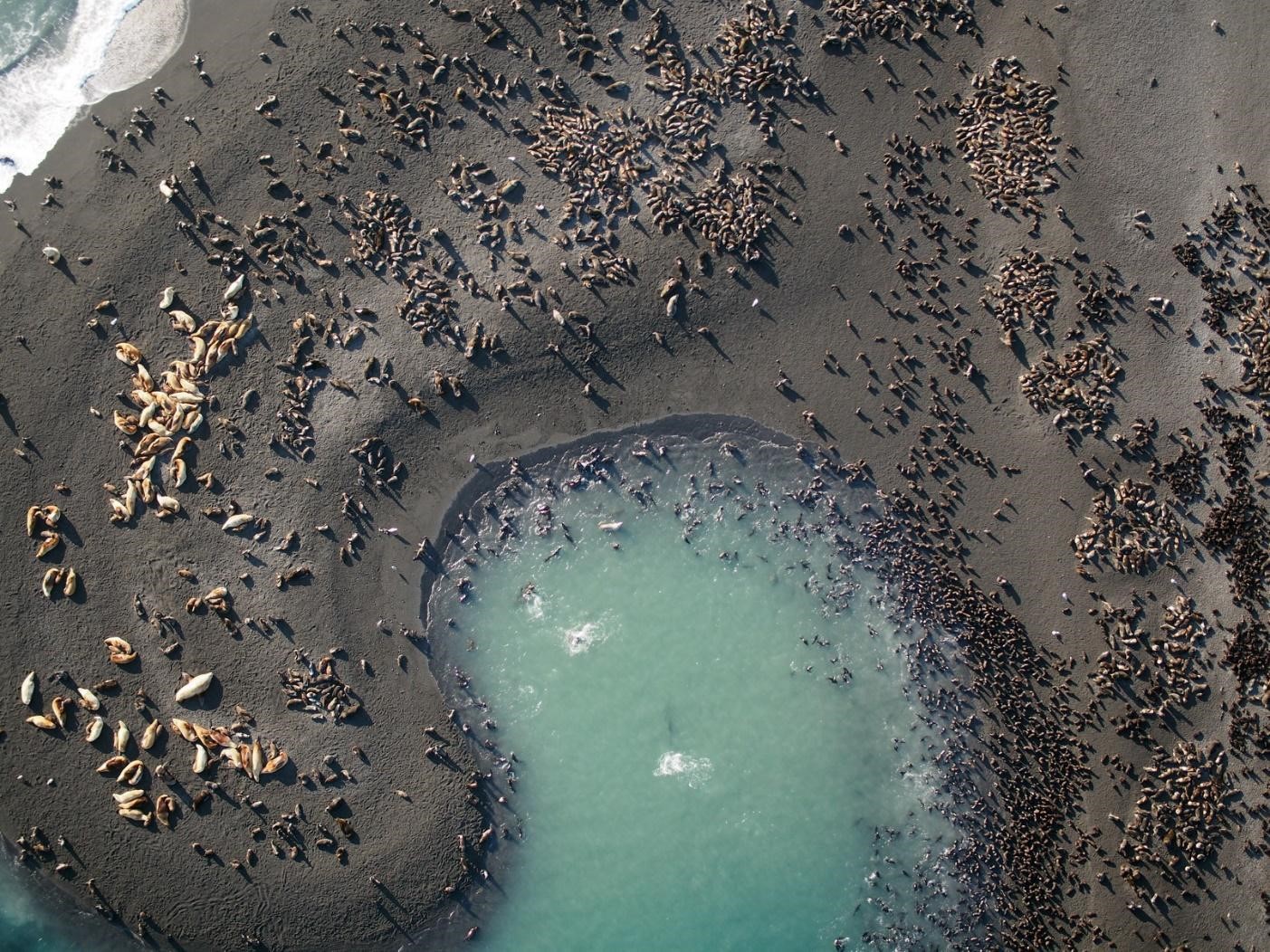 [Aerial photo of northern fur seals and Steller sea lions captured with the APH-28 hexacopter drone during aerial surveys on Bogoslof Island, AK, an active volcano. Credit: NOAA Fisheries]
Walking around an island off the coast of Alaska to look for and tag fur seal pups may sound like fun. And it is, says Katie Sweeney, a biologist with NOAA’s Alaska Fisheries Science Center. But it’s also slow, costly, and labor-intensive for the scientists — not to mention disruptive for the animals.
So Sweeney and her team are testing out the ability of small drones to count fur seals on the Pribilof Islands in the Bering Sea. It hasn’t been easy — fur seal pups are relatively small and black, and since they tend to hang out against the black, volcanic rock of the islands’ shorelines, it’s hard for the sensors on the drones to spot them. Sweeney’s team tested out a few different sensors, and found one that worked by using thermal, visual and multispectral imagery.
“With all three of those, we can identify fur seals confidently,” Sweeney said.
Now, her team is working on securing that sensor and a drone that can carry it — as it’s on the heavy side — then working to automate the process.
The goal is for the drones to replace traditional survey methods, which involve shearing small patches of fur off of about 10 percent of the seal pups, then coming back a few days later to count the number of sheared and unsheared pups to estimate population abundance. Once it’s fully integrated, the UAS method would involve just two researchers, rather than the 20 that the traditional shearing method uses. NOAA is already using drones to survey populations of polar bears and Steller sea lions, efforts that are critical to understanding whether these populations are healthy.
“Fur seals are in continued decline, and we’re trying to figure out why,” Sweeney said. “So it’s really important to do these surveys to continue to monitor the population.”
Improving Hurricane Forecasts
[Aerial photo of northern fur seals and Steller sea lions captured with the APH-28 hexacopter drone during aerial surveys on Bogoslof Island, AK, an active volcano. Credit: NOAA Fisheries]
Walking around an island off the coast of Alaska to look for and tag fur seal pups may sound like fun. And it is, says Katie Sweeney, a biologist with NOAA’s Alaska Fisheries Science Center. But it’s also slow, costly, and labor-intensive for the scientists — not to mention disruptive for the animals.
So Sweeney and her team are testing out the ability of small drones to count fur seals on the Pribilof Islands in the Bering Sea. It hasn’t been easy — fur seal pups are relatively small and black, and since they tend to hang out against the black, volcanic rock of the islands’ shorelines, it’s hard for the sensors on the drones to spot them. Sweeney’s team tested out a few different sensors, and found one that worked by using thermal, visual and multispectral imagery.
“With all three of those, we can identify fur seals confidently,” Sweeney said.
Now, her team is working on securing that sensor and a drone that can carry it — as it’s on the heavy side — then working to automate the process.
The goal is for the drones to replace traditional survey methods, which involve shearing small patches of fur off of about 10 percent of the seal pups, then coming back a few days later to count the number of sheared and unsheared pups to estimate population abundance. Once it’s fully integrated, the UAS method would involve just two researchers, rather than the 20 that the traditional shearing method uses. NOAA is already using drones to survey populations of polar bears and Steller sea lions, efforts that are critical to understanding whether these populations are healthy.
“Fur seals are in continued decline, and we’re trying to figure out why,” Sweeney said. “So it’s really important to do these surveys to continue to monitor the population.”
Improving Hurricane Forecasts
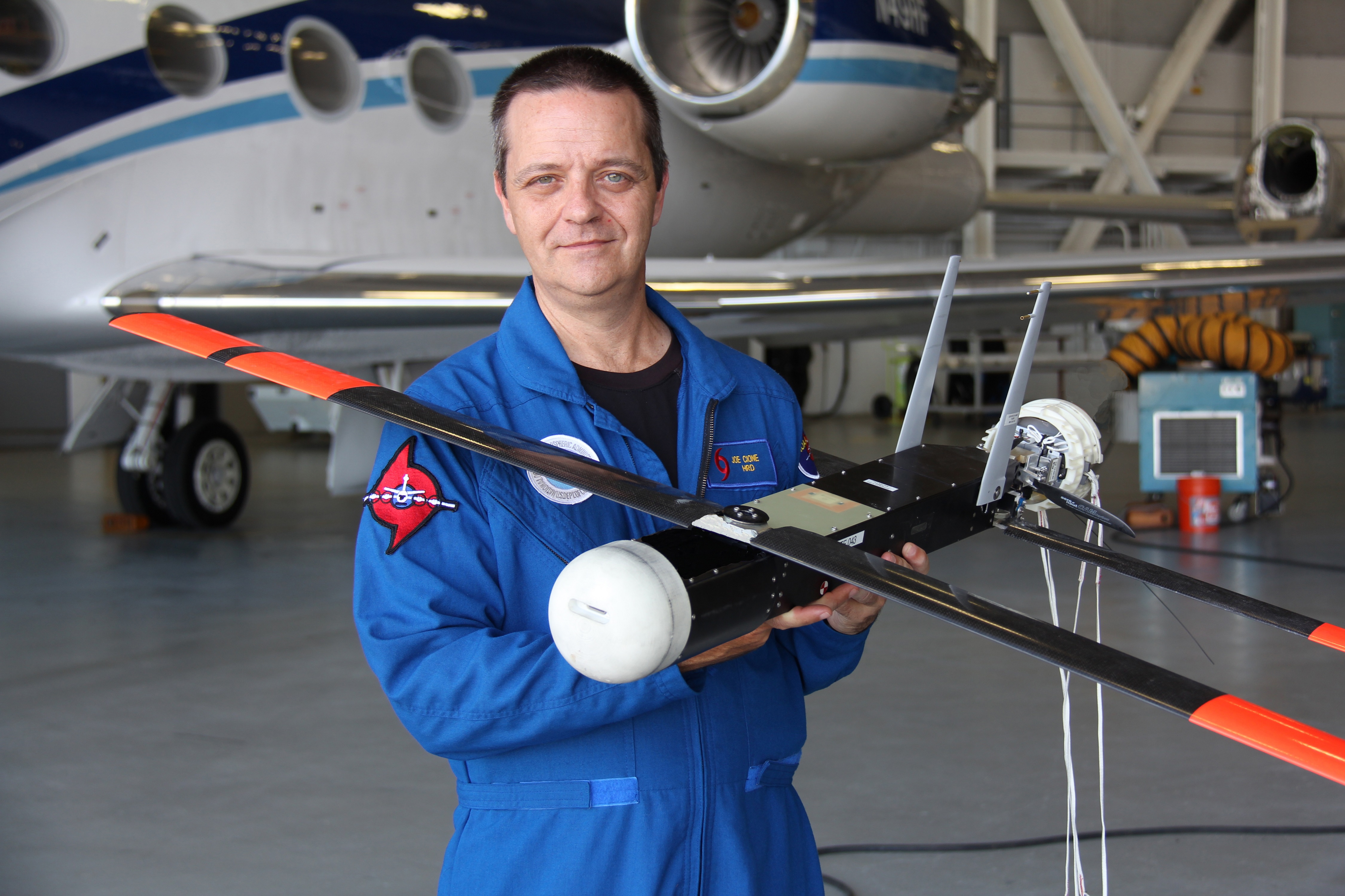 [Joe Cione holds the Coyote, a small UAS that has flown in three hurricanes. Credit: Joe Cione/NOAA AOML]
NOAA’s two P-3 aircraft are specially designed to fly into hurricanes (in fact, this year NOAA scientists flew a record 15 P-3 missions into Hurricane Dorian over an 11-day period). But these planes aren’t equipped to fly into the boundary layer — the space where the hurricane meets the surface of the ocean.
“That’s a very important part of the storm — it’s where it gets its energy from,” said Joseph Cione, a meteorologist at NOAA's Atlantic Oceanographic and
Meteorological Laboratory (AOML).
Cione is testing three small drones to see if they could one day fly regularly into the boundary layer of hurricanes. The data they collect would help scientists understand where the storm’s strongest winds are, the radius of maximum winds, and other variables like temperature, moisture and sea level pressure that all play into storm strength.
This data would help forecasters understand the strength of the approaching storm — which would allow emergency managers to make better decisions over when and whether to evacuate communities — and also feed into models to improve predictions of future hurricanes. Cione is working to get the three drones through the testing process, with the goal of making them a routine part of hurricane operations.
“Hopefully, this impacts society by giving us a better understanding of a storm, improving nowcasts — that situational awareness of a hurricane — and giving us better forecasts down the road,” Cione said.
Mapping Salmon Habitat
[Joe Cione holds the Coyote, a small UAS that has flown in three hurricanes. Credit: Joe Cione/NOAA AOML]
NOAA’s two P-3 aircraft are specially designed to fly into hurricanes (in fact, this year NOAA scientists flew a record 15 P-3 missions into Hurricane Dorian over an 11-day period). But these planes aren’t equipped to fly into the boundary layer — the space where the hurricane meets the surface of the ocean.
“That’s a very important part of the storm — it’s where it gets its energy from,” said Joseph Cione, a meteorologist at NOAA's Atlantic Oceanographic and
Meteorological Laboratory (AOML).
Cione is testing three small drones to see if they could one day fly regularly into the boundary layer of hurricanes. The data they collect would help scientists understand where the storm’s strongest winds are, the radius of maximum winds, and other variables like temperature, moisture and sea level pressure that all play into storm strength.
This data would help forecasters understand the strength of the approaching storm — which would allow emergency managers to make better decisions over when and whether to evacuate communities — and also feed into models to improve predictions of future hurricanes. Cione is working to get the three drones through the testing process, with the goal of making them a routine part of hurricane operations.
“Hopefully, this impacts society by giving us a better understanding of a storm, improving nowcasts — that situational awareness of a hurricane — and giving us better forecasts down the road,” Cione said.
Mapping Salmon Habitat
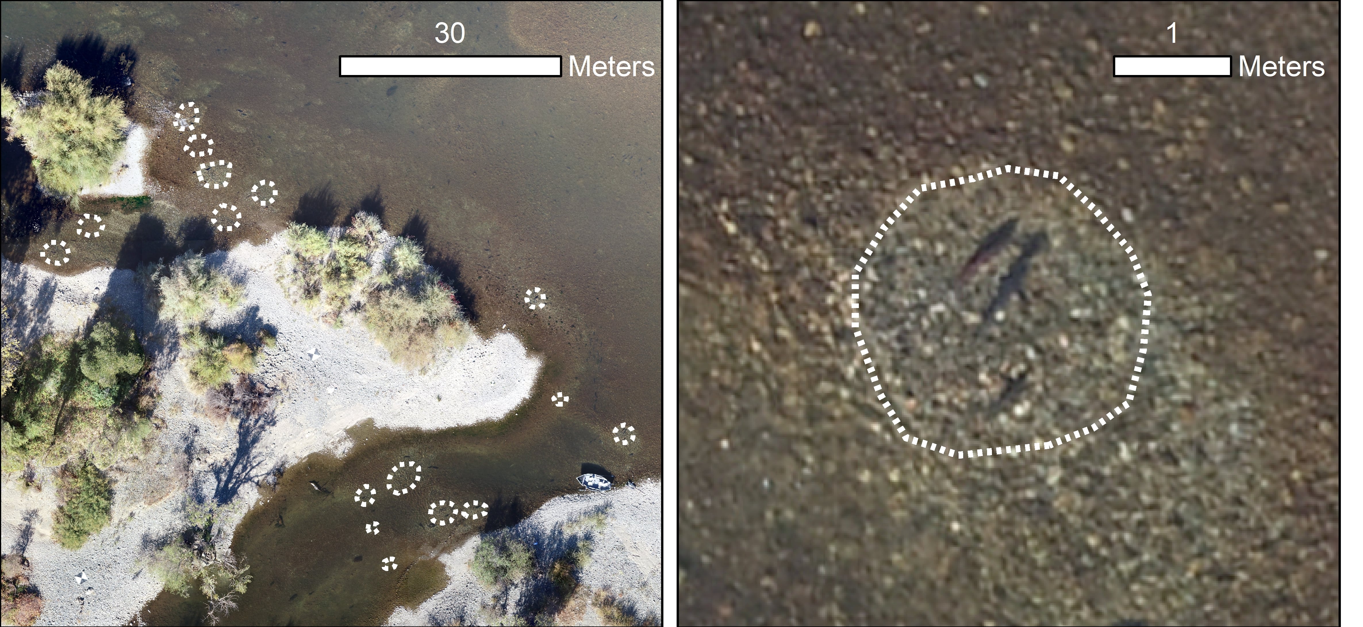 [Aerial photograph of the American River, located in northern California, obtained from a small drone. The white, dashed circles in each panel represent mapped salmon redds. The right panel shows a zoom image of an individual redd, occupied by spawning salmon. Credit: Lee Harrison, NOAA Fisheries]
Lee Harrison, a research hydrologist at NOAA’s Southwest Fisheries Science Center, is working on two projects using drones to collect data on the river habitats of endangered Chinook salmon. These drones can be deployed at low altitudes over the river, and can hover in place over certain areas in order to get detailed information about where these salmon make their homes. When it comes to measuring water depth, Harrison’s research has shown that data from the drones were comparable to more traditional remote sensing methods used for mapping salmon habitats.
“If you have a continuous water depth map, you can see how river habitats are distributed for salmon that can be used at different life stages,” Harrison said. “For example, adult salmon spawn in swift, shallow water, while juvenile fish typically use deeper, slow-moving pools.”
Harrison is also using drones to spot salmon nests — called “redds” — so that scientists can make estimates of how many eggs will be produced in a given year. Improving salmon habitats that have been impacted by dams has become a major part of river restoration programs in the United States, and by mapping the redds in those restored areas, scientists can see how effective a restoration project has been.
Identifying Harmful Algal Blooms
[Aerial photograph of the American River, located in northern California, obtained from a small drone. The white, dashed circles in each panel represent mapped salmon redds. The right panel shows a zoom image of an individual redd, occupied by spawning salmon. Credit: Lee Harrison, NOAA Fisheries]
Lee Harrison, a research hydrologist at NOAA’s Southwest Fisheries Science Center, is working on two projects using drones to collect data on the river habitats of endangered Chinook salmon. These drones can be deployed at low altitudes over the river, and can hover in place over certain areas in order to get detailed information about where these salmon make their homes. When it comes to measuring water depth, Harrison’s research has shown that data from the drones were comparable to more traditional remote sensing methods used for mapping salmon habitats.
“If you have a continuous water depth map, you can see how river habitats are distributed for salmon that can be used at different life stages,” Harrison said. “For example, adult salmon spawn in swift, shallow water, while juvenile fish typically use deeper, slow-moving pools.”
Harrison is also using drones to spot salmon nests — called “redds” — so that scientists can make estimates of how many eggs will be produced in a given year. Improving salmon habitats that have been impacted by dams has become a major part of river restoration programs in the United States, and by mapping the redds in those restored areas, scientists can see how effective a restoration project has been.
Identifying Harmful Algal Blooms
 [Aerial photograph of the American River, located in northern California, obtained from a small drone. The white, dashed circles in each panel represent mapped salmon redds. The right panel shows a zoom image of an individual redd, occupied by spawning salmon. Credit: Lee Harrison, NOAA Fisheries]
Harmful algal blooms don’t just pose a risk to fish and other marine life — they’re also a health risk to humans, causing respiratory problems especially in those with asthma or other lung conditions. Right now, the two options for mapping algal blooms in the ocean are taking water samples from the affected area or using satellites, which can spot the blooms from the air.
But neither of those methods provide information quickly enough to provide up-to-date forecasts for beach-goers, who need to know whether its safe to visit the ocean on any given day.
"UAS can be flown to locate blooms and determine how extensive they are. They have the potential to go out every day or every other day," said Rick Stumpf, oceanographer at NOAA National Centers for Coastal Ocean Science.
Stumpf just started a project to test drones to identify and map harmful algal blooms near shorelines in the U.S. These drones will carry a custom sensor that can capture the fluorescence blooms create when hit by sunlight and relay information on these blooms to scientists in real time.
Florida, in particular, suffers red tides on a yearly basis, so knowing which days allow for safe beach-going will help protect Florida residents and tourists from unwanted respiratory impacts, and help coastal restaurants and shops keep their business during days when beach-going is safe. Stumpf hopes that, with some testing, drones can be used to inform these timely forecasts.
[Aerial photograph of the American River, located in northern California, obtained from a small drone. The white, dashed circles in each panel represent mapped salmon redds. The right panel shows a zoom image of an individual redd, occupied by spawning salmon. Credit: Lee Harrison, NOAA Fisheries]
Harmful algal blooms don’t just pose a risk to fish and other marine life — they’re also a health risk to humans, causing respiratory problems especially in those with asthma or other lung conditions. Right now, the two options for mapping algal blooms in the ocean are taking water samples from the affected area or using satellites, which can spot the blooms from the air.
But neither of those methods provide information quickly enough to provide up-to-date forecasts for beach-goers, who need to know whether its safe to visit the ocean on any given day.
"UAS can be flown to locate blooms and determine how extensive they are. They have the potential to go out every day or every other day," said Rick Stumpf, oceanographer at NOAA National Centers for Coastal Ocean Science.
Stumpf just started a project to test drones to identify and map harmful algal blooms near shorelines in the U.S. These drones will carry a custom sensor that can capture the fluorescence blooms create when hit by sunlight and relay information on these blooms to scientists in real time.
Florida, in particular, suffers red tides on a yearly basis, so knowing which days allow for safe beach-going will help protect Florida residents and tourists from unwanted respiratory impacts, and help coastal restaurants and shops keep their business during days when beach-going is safe. Stumpf hopes that, with some testing, drones can be used to inform these timely forecasts.
[Aerial photo of northern fur seals and Steller sea lions captured with the APH-28 hexacopter drone during aerial surveys on Bogoslof Island, AK, an active volcano. Credit: NOAA Fisheries]
Walking around an island off the coast of Alaska to look for and tag fur seal pups may sound like fun. And it is, says Katie Sweeney, a biologist with NOAA’s Alaska Fisheries Science Center. But it’s also slow, costly, and labor-intensive for the scientists — not to mention disruptive for the animals.
So Sweeney and her team are testing out the ability of small drones to count fur seals on the Pribilof Islands in the Bering Sea. It hasn’t been easy — fur seal pups are relatively small and black, and since they tend to hang out against the black, volcanic rock of the islands’ shorelines, it’s hard for the sensors on the drones to spot them. Sweeney’s team tested out a few different sensors, and found one that worked by using thermal, visual and multispectral imagery.
“With all three of those, we can identify fur seals confidently,” Sweeney said.
Now, her team is working on securing that sensor and a drone that can carry it — as it’s on the heavy side — then working to automate the process.
The goal is for the drones to replace traditional survey methods, which involve shearing small patches of fur off of about 10 percent of the seal pups, then coming back a few days later to count the number of sheared and unsheared pups to estimate population abundance. Once it’s fully integrated, the UAS method would involve just two researchers, rather than the 20 that the traditional shearing method uses. NOAA is already using drones to survey populations of polar bears and Steller sea lions, efforts that are critical to understanding whether these populations are healthy.
“Fur seals are in continued decline, and we’re trying to figure out why,” Sweeney said. “So it’s really important to do these surveys to continue to monitor the population.”
Improving Hurricane Forecasts
[Joe Cione holds the Coyote, a small UAS that has flown in three hurricanes. Credit: Joe Cione/NOAA AOML]
NOAA’s two P-3 aircraft are specially designed to fly into hurricanes (in fact, this year NOAA scientists flew a record 15 P-3 missions into Hurricane Dorian over an 11-day period). But these planes aren’t equipped to fly into the boundary layer — the space where the hurricane meets the surface of the ocean.
“That’s a very important part of the storm — it’s where it gets its energy from,” said Joseph Cione, a meteorologist at NOAA's Atlantic Oceanographic and
Meteorological Laboratory (AOML).
Cione is testing three small drones to see if they could one day fly regularly into the boundary layer of hurricanes. The data they collect would help scientists understand where the storm’s strongest winds are, the radius of maximum winds, and other variables like temperature, moisture and sea level pressure that all play into storm strength.
This data would help forecasters understand the strength of the approaching storm — which would allow emergency managers to make better decisions over when and whether to evacuate communities — and also feed into models to improve predictions of future hurricanes. Cione is working to get the three drones through the testing process, with the goal of making them a routine part of hurricane operations.
“Hopefully, this impacts society by giving us a better understanding of a storm, improving nowcasts — that situational awareness of a hurricane — and giving us better forecasts down the road,” Cione said.
Mapping Salmon Habitat
[Aerial photograph of the American River, located in northern California, obtained from a small drone. The white, dashed circles in each panel represent mapped salmon redds. The right panel shows a zoom image of an individual redd, occupied by spawning salmon. Credit: Lee Harrison, NOAA Fisheries]
Lee Harrison, a research hydrologist at NOAA’s Southwest Fisheries Science Center, is working on two projects using drones to collect data on the river habitats of endangered Chinook salmon. These drones can be deployed at low altitudes over the river, and can hover in place over certain areas in order to get detailed information about where these salmon make their homes. When it comes to measuring water depth, Harrison’s research has shown that data from the drones were comparable to more traditional remote sensing methods used for mapping salmon habitats.
“If you have a continuous water depth map, you can see how river habitats are distributed for salmon that can be used at different life stages,” Harrison said. “For example, adult salmon spawn in swift, shallow water, while juvenile fish typically use deeper, slow-moving pools.”
Harrison is also using drones to spot salmon nests — called “redds” — so that scientists can make estimates of how many eggs will be produced in a given year. Improving salmon habitats that have been impacted by dams has become a major part of river restoration programs in the United States, and by mapping the redds in those restored areas, scientists can see how effective a restoration project has been.
Identifying Harmful Algal Blooms
[Aerial photograph of the American River, located in northern California, obtained from a small drone. The white, dashed circles in each panel represent mapped salmon redds. The right panel shows a zoom image of an individual redd, occupied by spawning salmon. Credit: Lee Harrison, NOAA Fisheries]
Harmful algal blooms don’t just pose a risk to fish and other marine life — they’re also a health risk to humans, causing respiratory problems especially in those with asthma or other lung conditions. Right now, the two options for mapping algal blooms in the ocean are taking water samples from the affected area or using satellites, which can spot the blooms from the air.
But neither of those methods provide information quickly enough to provide up-to-date forecasts for beach-goers, who need to know whether its safe to visit the ocean on any given day.
"UAS can be flown to locate blooms and determine how extensive they are. They have the potential to go out every day or every other day," said Rick Stumpf, oceanographer at NOAA National Centers for Coastal Ocean Science.
Stumpf just started a project to test drones to identify and map harmful algal blooms near shorelines in the U.S. These drones will carry a custom sensor that can capture the fluorescence blooms create when hit by sunlight and relay information on these blooms to scientists in real time.
Florida, in particular, suffers red tides on a yearly basis, so knowing which days allow for safe beach-going will help protect Florida residents and tourists from unwanted respiratory impacts, and help coastal restaurants and shops keep their business during days when beach-going is safe. Stumpf hopes that, with some testing, drones can be used to inform these timely forecasts.
All Weather News
More
NHC Monitoring Front in the Southeast Ahead of 4th of July
Tropical downpours for a long holiday weekend
3 Jul 2025 9:25 PM

Flossie is No More, Eastern Pacific Remains Active
Post Tropical FlossieThe National Hurricane C
3 Jul 2025 9:15 PM

Near Seasonal Temperatures for Many Come July 4th!
AAA is expecting over 70 million travelers to
3 Jul 2025 9:05 PM


Severe Storms in the Midwest Could Dampen Holiday Plans
NORTHERN PLAINS - A frontal system is expecte
3 Jul 2025 8:00 PM

Northwest Heat Met With Thunderstorm Risk
NORTHWEST - Today, portions of Montana are un
3 Jul 2025 12:00 AM

Severe Weather Threat Continues in the Midwest
It has been an active, severe season across t
30 Jun 2025 9:00 PM