Drought Status Updated: How's Your Area?
Special Stories
30 Jul 2020 2:00 PM
The weekly Drought Monitor was released Thursday morning, as it is every Thursday with data through Tuesday of each week, and it shows some pretty distinct changes in parts of the country. Let's take a look:
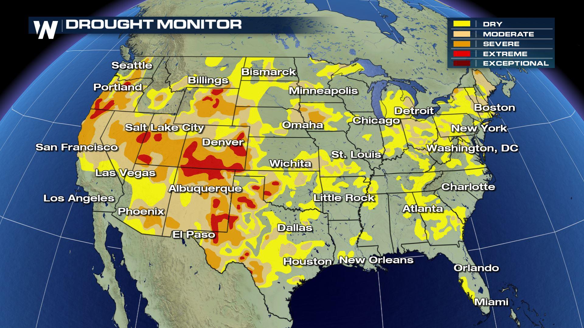
 The Drought Monitor updated Thursday, July 30. The data in this image is valid through Tuesday, July 28
The national view of the Drought Monitor shows that a majority of the country is on the dry side. Roughly 75% of the Lower 48 is experiencing at least "abnormally dry" conditions, shaded in yellow. That means about one-quarter of the Contiguous U.S. is experiencing average or above-average soil moisture conditions.
Here are some highlights when we compare this week's data to last week's data:
The Drought Monitor updated Thursday, July 30. The data in this image is valid through Tuesday, July 28
The national view of the Drought Monitor shows that a majority of the country is on the dry side. Roughly 75% of the Lower 48 is experiencing at least "abnormally dry" conditions, shaded in yellow. That means about one-quarter of the Contiguous U.S. is experiencing average or above-average soil moisture conditions.
Here are some highlights when we compare this week's data to last week's data:
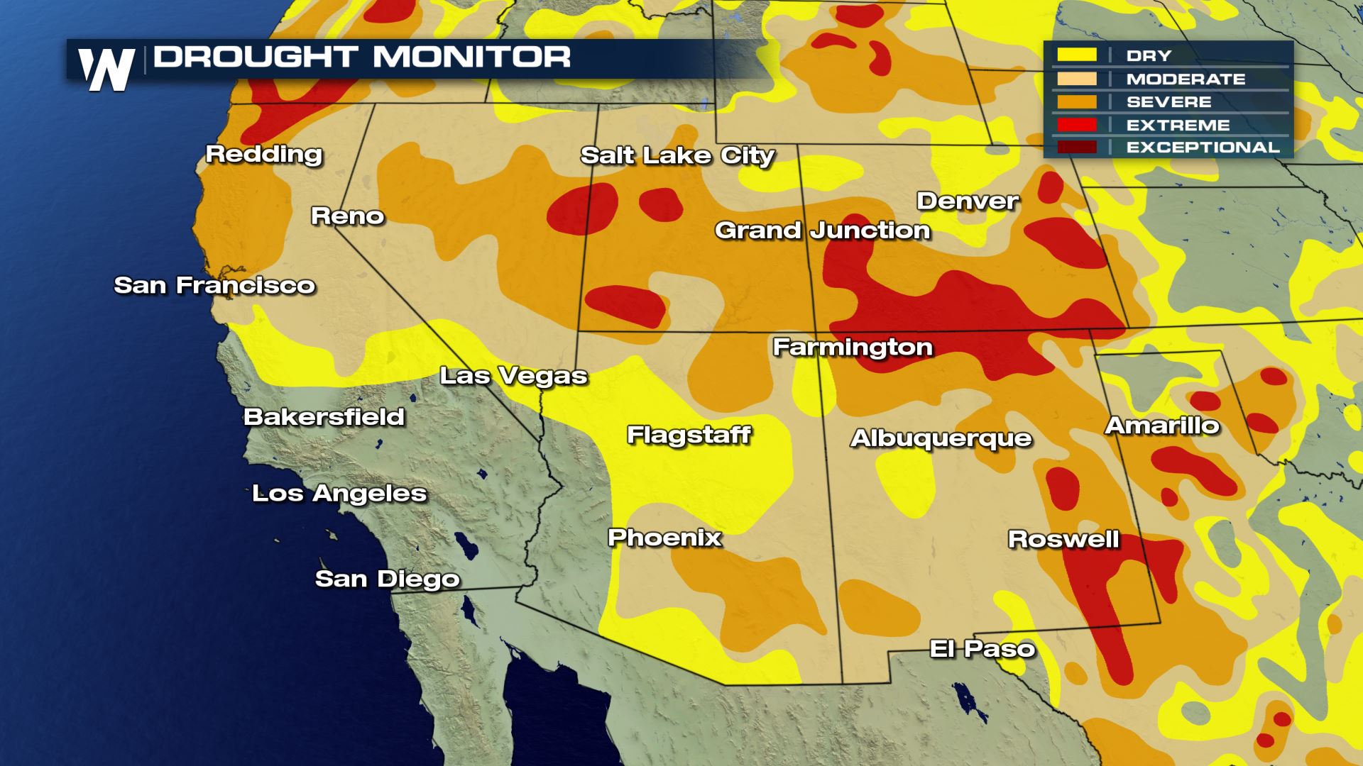 The weekly Drought Monitor for the Southwest U.S. released Thursday, July 30
Some of the biggest weekly changes were seen across the Southwest U.S. where states including Arizona, Colorado, Utah, and Wyoming experienced worsening drought. This is the time of the year when the monsoon showers and thunderstorms help replenish the water table, but unfortunately the monsoon has been weak in most areas. Take for instance, Arizona:
https://twitter.com/NWSPhoenix/status/1288672083149430784
The National Weather Service office in Phoenix, Arizona has been tracking the number of lightning strikes across the state as a way to monitor the strength of this year's monsoon. So far, it has been a very quiet wet season.
The weekly Drought Monitor for the Southwest U.S. released Thursday, July 30
Some of the biggest weekly changes were seen across the Southwest U.S. where states including Arizona, Colorado, Utah, and Wyoming experienced worsening drought. This is the time of the year when the monsoon showers and thunderstorms help replenish the water table, but unfortunately the monsoon has been weak in most areas. Take for instance, Arizona:
https://twitter.com/NWSPhoenix/status/1288672083149430784
The National Weather Service office in Phoenix, Arizona has been tracking the number of lightning strikes across the state as a way to monitor the strength of this year's monsoon. So far, it has been a very quiet wet season.
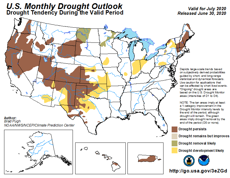 The monthly drought outlook, going forward, shows drought continuing for much of the West with further drought development likely for parts of Arizona and New Mexico. Unfortunately in the near term, between July 31 and August 12, the precipitation outlook for the West favors higher chances of drier-than-average conditions. This is attributed to the massive area of heat parked over the West right now, not allowing many thunderstorms to pop up.
The Drought Monitor updated Thursday, July 30. The data in this image is valid through Tuesday, July 28
The national view of the Drought Monitor shows that a majority of the country is on the dry side. Roughly 75% of the Lower 48 is experiencing at least "abnormally dry" conditions, shaded in yellow. That means about one-quarter of the Contiguous U.S. is experiencing average or above-average soil moisture conditions.
Here are some highlights when we compare this week's data to last week's data:
- No location is in Exceptional Drought (the worst ranking on the scale)
- The West saw drought development in all categories (moderate, severe, and extreme drought)
- There were many areas which had below-average precipitation during the past week
- Looking ahead, the West will likely face the toughest conditions
The weekly Drought Monitor for the Southwest U.S. released Thursday, July 30
Some of the biggest weekly changes were seen across the Southwest U.S. where states including Arizona, Colorado, Utah, and Wyoming experienced worsening drought. This is the time of the year when the monsoon showers and thunderstorms help replenish the water table, but unfortunately the monsoon has been weak in most areas. Take for instance, Arizona:
https://twitter.com/NWSPhoenix/status/1288672083149430784
The National Weather Service office in Phoenix, Arizona has been tracking the number of lightning strikes across the state as a way to monitor the strength of this year's monsoon. So far, it has been a very quiet wet season.
The monthly drought outlook, going forward, shows drought continuing for much of the West with further drought development likely for parts of Arizona and New Mexico. Unfortunately in the near term, between July 31 and August 12, the precipitation outlook for the West favors higher chances of drier-than-average conditions. This is attributed to the massive area of heat parked over the West right now, not allowing many thunderstorms to pop up.All Weather News
More

Flooding, Severe Storms Target the Midwest Again
After an active week of storms across the nor
31 Jul 2026 11:15 PM


After Reaching Category 5, Genevieve Weakens in the Pacific
PacificFausto is now a post-tropical cyclone.
31 Jul 2026 1:30 AM

Flooding Risk Increases as Heavy Rain Targets the Tri-State Area
Tuesday, heavy rainfall moved across the Nort
30 Jul 2026 12:25 AM

Severe Weather: Energy From the Midwest Now in the Southeast
UPPER MIDWEST - Through Monday, dangerous tor
29 Jul 2026 10:30 PM