Farewell to GOES-13: The History of NOAA’s Former GOES East Satellite
Special Stories
17 Jan 2018 9:25 AM
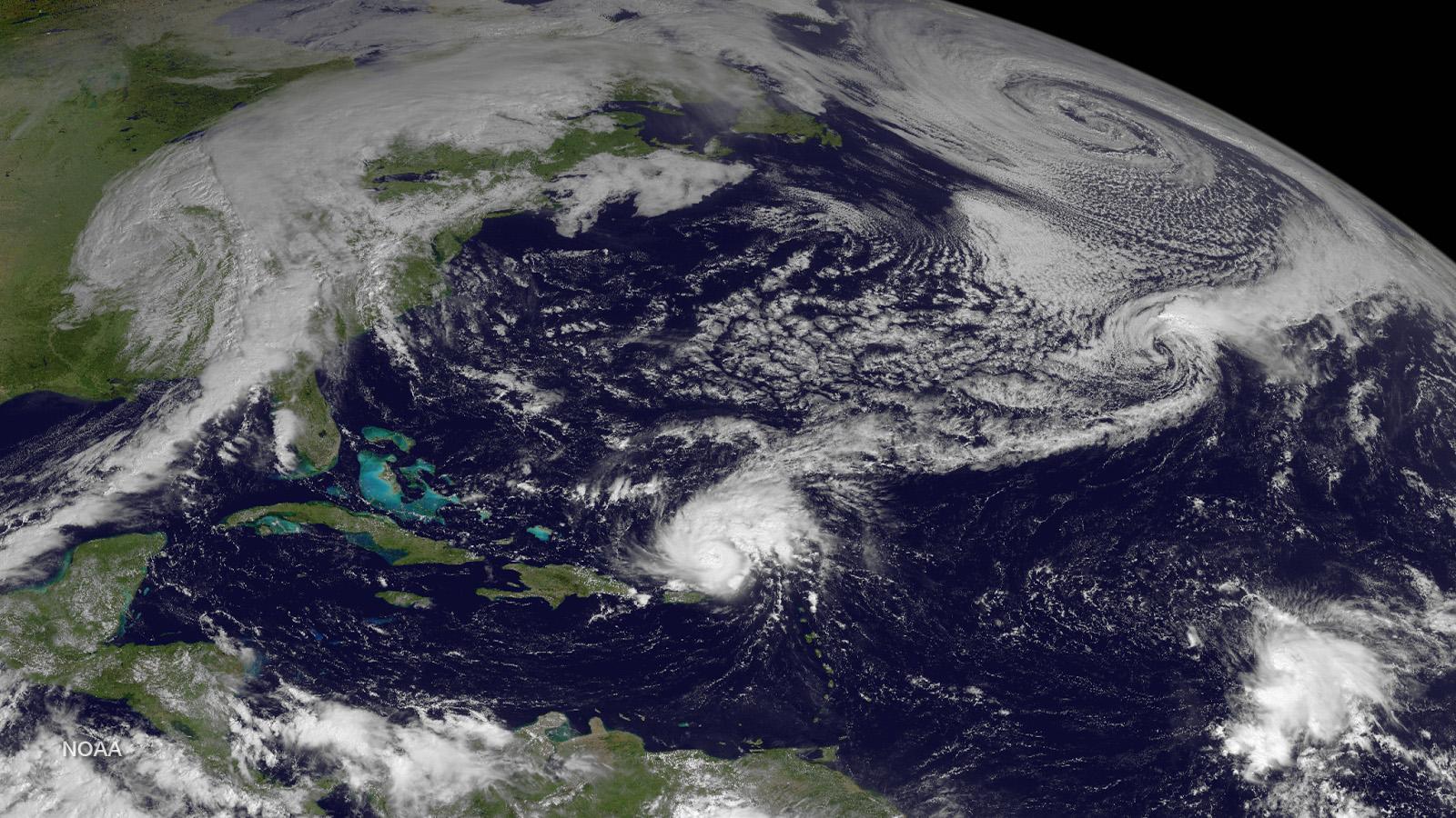
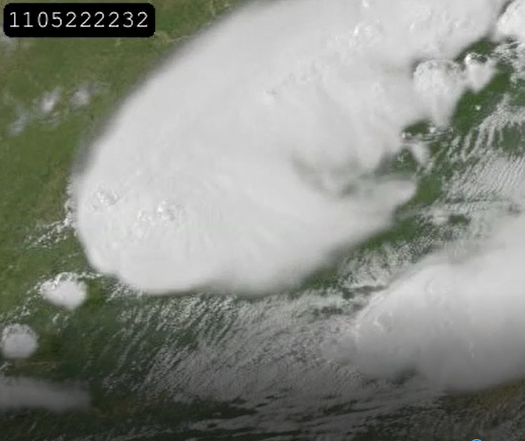
[GOES-13 views Hurricane Gonzalo in the Caribbean and active weather across the western and central North Atlantic on October 14, 2014.]
From NOAA NESDIS
For more than seven years, NOAA’s GOES-13 satellite has been actively monitoring the skies over the Western Hemisphere, serving as a critical source of information during major U.S. weather events, from crippling snowstorms to powerful hurricanes. Here’s a look back at the satellite’s unique history and its most memorable imagery.
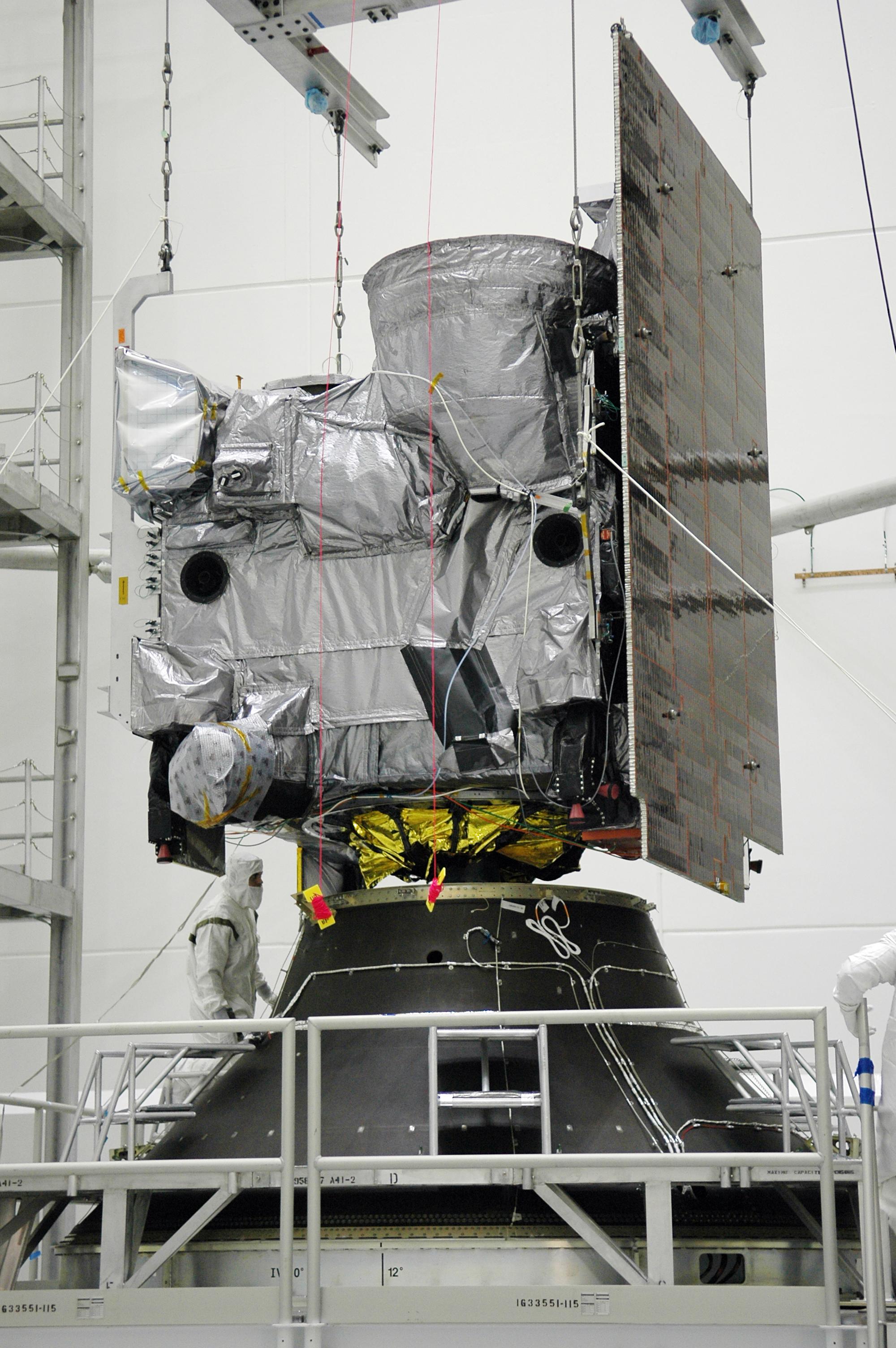 [GOES-13 lowered onto the payload adapter at NASA's Kennedy Space, April 2006]
When GOES-13 was first launched aboard a Boeing Delta-IV rocket from Cape Canaveral Air Force Station in May 2006, the spacecraft joined a new generation of satellites known as the GOES-N,O,P series. These satellites were designed with a longer lifespan than their predecessors, and would carry enough fuel to operate for nearly 14 years.
[GOES-13 lowered onto the payload adapter at NASA's Kennedy Space, April 2006]
When GOES-13 was first launched aboard a Boeing Delta-IV rocket from Cape Canaveral Air Force Station in May 2006, the spacecraft joined a new generation of satellites known as the GOES-N,O,P series. These satellites were designed with a longer lifespan than their predecessors, and would carry enough fuel to operate for nearly 14 years.
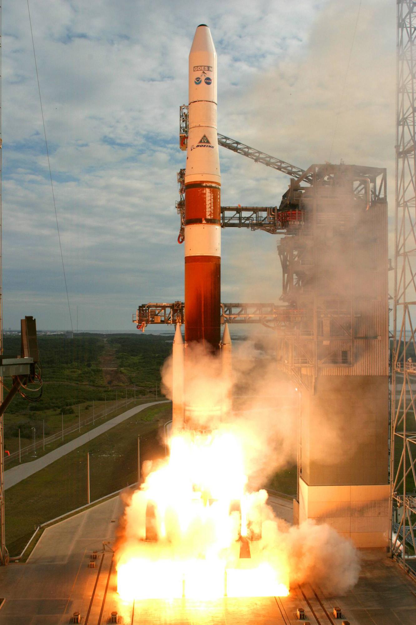 [Launch of GOES-13 from the Kennedy Space Center in Florida on May 24, 2006]
With faster data processing, GOES-13 could pinpoint the location of severe storms and other weather phenomena with increased accuracy, allowing forecasters to provide timelier warnings to the public. The satellite’s imager and sounder sensors could take more precise vertical measurements of the Earth’s atmosphere, which enabled the satellite to track major weather events such as hurricanes and tropical cyclones in near-real time.
[Launch of GOES-13 from the Kennedy Space Center in Florida on May 24, 2006]
With faster data processing, GOES-13 could pinpoint the location of severe storms and other weather phenomena with increased accuracy, allowing forecasters to provide timelier warnings to the public. The satellite’s imager and sounder sensors could take more precise vertical measurements of the Earth’s atmosphere, which enabled the satellite to track major weather events such as hurricanes and tropical cyclones in near-real time.
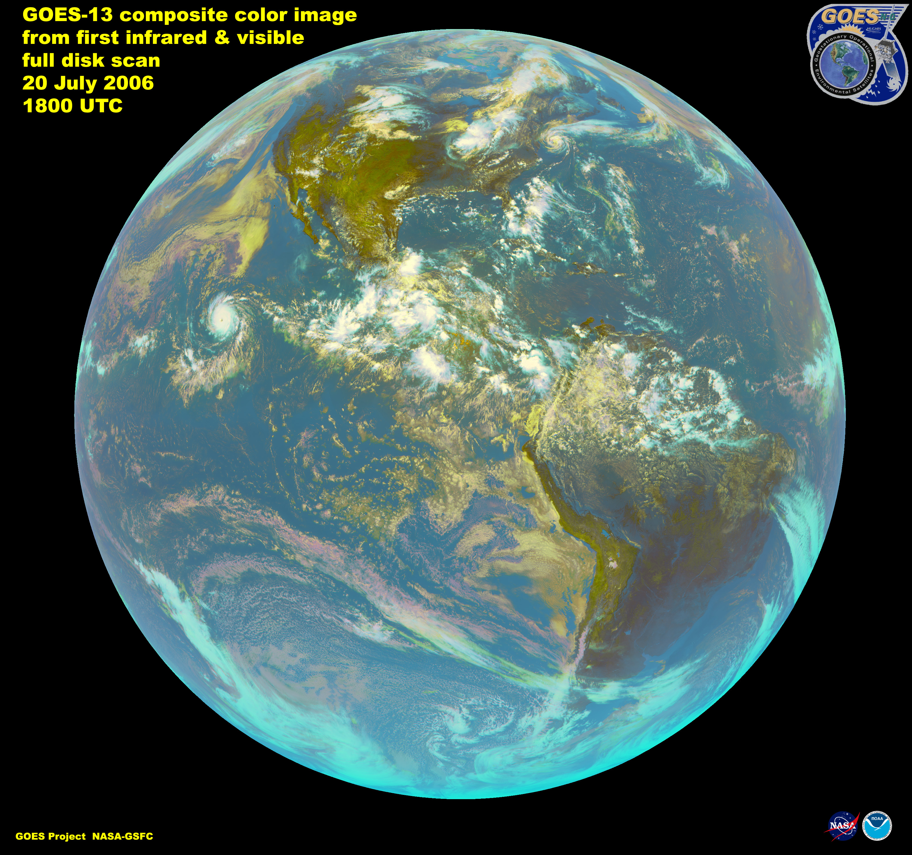 [First imagery from GOES-13 in 2006]
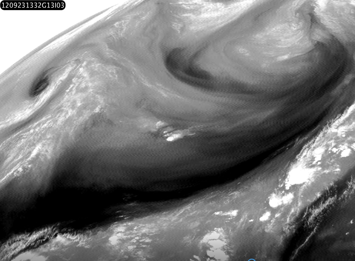 [From September 23, 2012. Some of the infrared images from GOES-13 (then GOES-EAST at 75W) started showing a faint high frequency "buzz" at the same time as the mirror scan motors developed loading problems. Ripples in brightness can be seen along scan lines in the frames of a contrast-enhanced movie from the 6.7 micron water vapor channel over the eastern USA before the Imager was turned off for diagnostic study.]
Then, in September 2012, the satellite suddenly started sending back blurry images with a lot of “noise.” To fix the problem, NOAA had to place GOES-13 in standby mode for nearly a month. In the meantime, NOAA began moving a spare satellite, GOES-14, to GOES-13’s orbital position.
NOAA engineers determined that GOES-13’s blurry images were caused by aging lubricant in the satellite’s sounder system. The buildup was preventing the filter wheel from spinning properly, causing the images to appear grainy. After weeks of extensive testing, the satellite mission operations team successfully put GOES-13 back into service in mid-October 2012.
[From September 23, 2012. Some of the infrared images from GOES-13 (then GOES-EAST at 75W) started showing a faint high frequency "buzz" at the same time as the mirror scan motors developed loading problems. Ripples in brightness can be seen along scan lines in the frames of a contrast-enhanced movie from the 6.7 micron water vapor channel over the eastern USA before the Imager was turned off for diagnostic study.]
Then, in September 2012, the satellite suddenly started sending back blurry images with a lot of “noise.” To fix the problem, NOAA had to place GOES-13 in standby mode for nearly a month. In the meantime, NOAA began moving a spare satellite, GOES-14, to GOES-13’s orbital position.
NOAA engineers determined that GOES-13’s blurry images were caused by aging lubricant in the satellite’s sounder system. The buildup was preventing the filter wheel from spinning properly, causing the images to appear grainy. After weeks of extensive testing, the satellite mission operations team successfully put GOES-13 back into service in mid-October 2012.
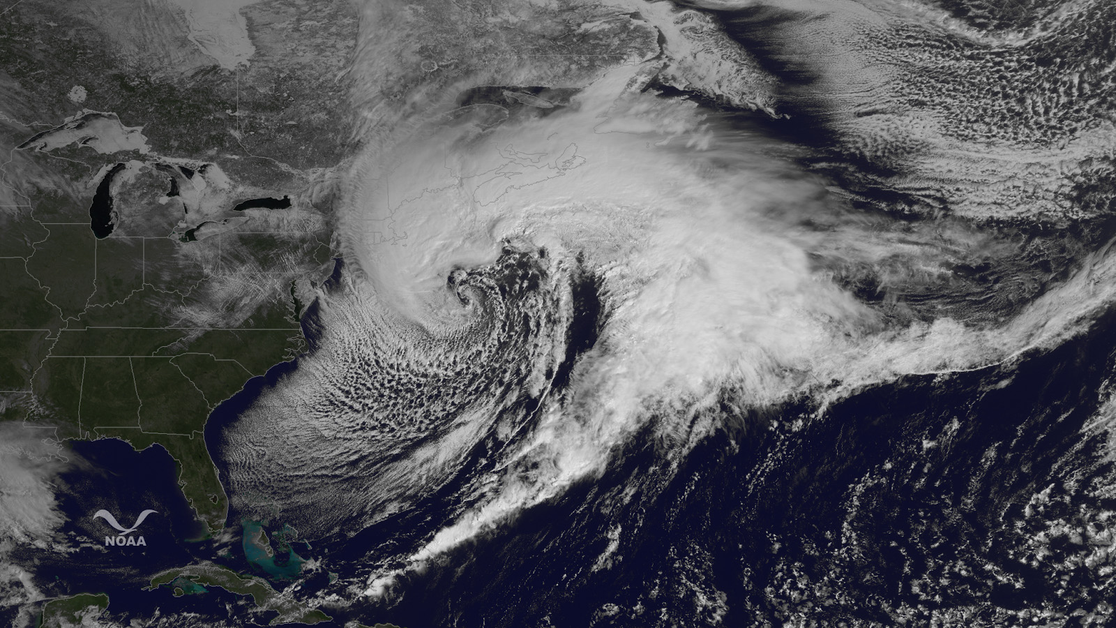
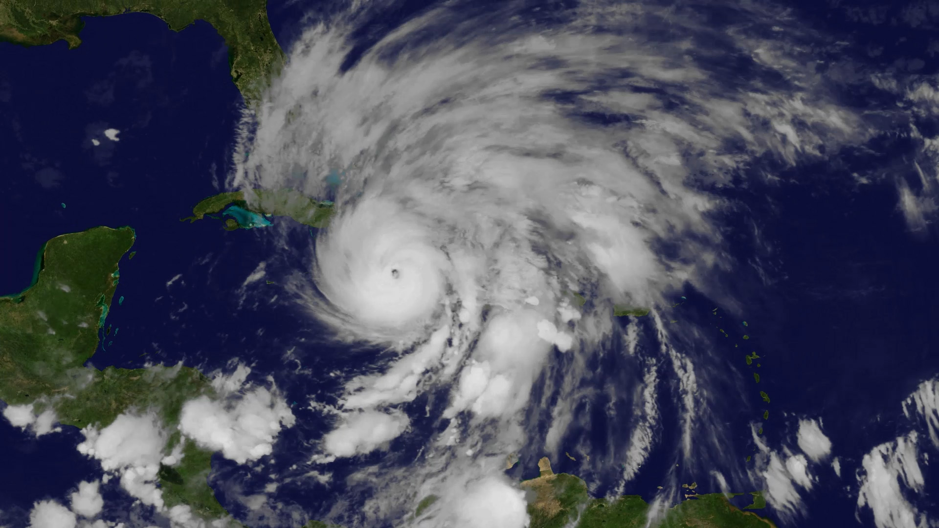 [GOES-13 view of Hurricane Sandy intensifying the Caribbean Sea before the storm tracked up the U.S. East Coast in October 2012.]
The fix came just in time. Less than two weeks later, Hurricane Sandy battered the East Coast with damaging winds and historic coastal flooding. Of course, NOAA always has backup plans in case one of its satellites experiences technical difficulties. As Hurricane Sandy approached the U.S., GOES-14 was providing a second set of eyes on the storm, monitoring it from 22,300 miles above Earth, right alongside GOES-13.
Despite these and other challenges, GOES-13 has provided valuable information about our weather throughout its years in service. Moreover, the satellite will continue to remain available as a backup source if another one of NOAA’s operational satellites experiences technical problems.
[GOES-13 view of Hurricane Sandy intensifying the Caribbean Sea before the storm tracked up the U.S. East Coast in October 2012.]
The fix came just in time. Less than two weeks later, Hurricane Sandy battered the East Coast with damaging winds and historic coastal flooding. Of course, NOAA always has backup plans in case one of its satellites experiences technical difficulties. As Hurricane Sandy approached the U.S., GOES-14 was providing a second set of eyes on the storm, monitoring it from 22,300 miles above Earth, right alongside GOES-13.
Despite these and other challenges, GOES-13 has provided valuable information about our weather throughout its years in service. Moreover, the satellite will continue to remain available as a backup source if another one of NOAA’s operational satellites experiences technical problems.
 [The largest tornado outbreak since 1974 occurred over the southeast USA during the night of 27-28 April 2011. Over 300 people were killed in more than 160 tornados, mainly in northern Alabama.]
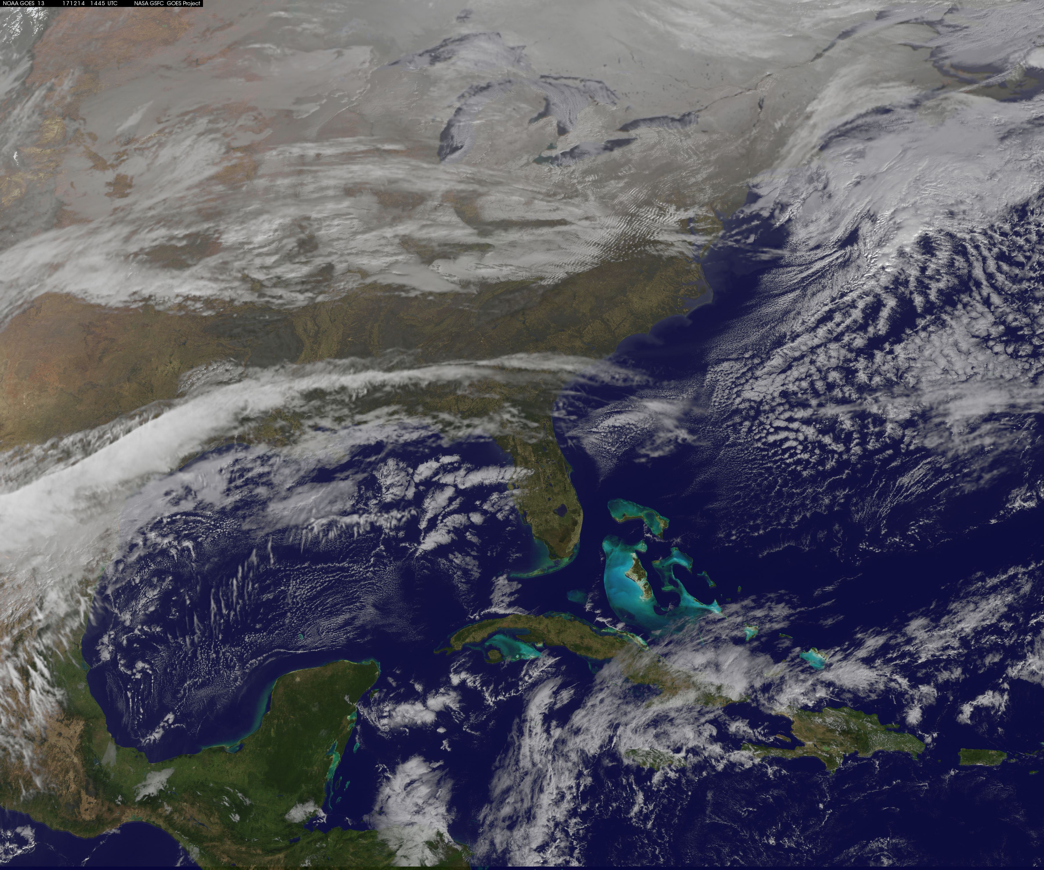 [From December 14, 2017. This is last satellite image collected by and broadcast by GOES-13 in the GOES-EAST orbital slot at 75 W longitude, and processed here to place the cloud imagery over a true-color background map. GOES-13 will be put in storage at 60 W longitude, as an "emergency spare".]
For the past three weeks, the satellite duo have practically been neighbors in the sky - with GOES-16 watching over Earth at 75.2 degrees west longitude and its older cousin, GOES-13, at 75.0 degrees west.
On January 8, GOES-13 said goodbye to its next-door neighbor, GOES-16, and began a three-week journey to its on-orbit storage location, where it will be kept unless it is needed as a backup satellite.
[From December 14, 2017. This is last satellite image collected by and broadcast by GOES-13 in the GOES-EAST orbital slot at 75 W longitude, and processed here to place the cloud imagery over a true-color background map. GOES-13 will be put in storage at 60 W longitude, as an "emergency spare".]
For the past three weeks, the satellite duo have practically been neighbors in the sky - with GOES-16 watching over Earth at 75.2 degrees west longitude and its older cousin, GOES-13, at 75.0 degrees west.
On January 8, GOES-13 said goodbye to its next-door neighbor, GOES-16, and began a three-week journey to its on-orbit storage location, where it will be kept unless it is needed as a backup satellite.
 [A wave of severe storms swept across the central USA on Sunday, 22 May 2011, with tornado warnings from Minneapolis to Dallas. The most damaging storm struck Joplin MO at 5:30 pm local time, killing at least 118 people.]
In a process known as “drift,” GOES-13 began moving to its new storage location, at 60 degrees west longitude (for reference, that’s about the longitude of Nova Scotia, Canada). For a geosynchronous satellite to change its orbital position over the Earth, NOAA’s operations team must maneuver the satellite using a series of commands uploaded to the spacecraft’s memory. Similar to GOES-16’s own drift process in early December 2017, the operations team first had to lower GOES-13 slightly - by about 60 miles - to get it moving into its new orbit.
[A wave of severe storms swept across the central USA on Sunday, 22 May 2011, with tornado warnings from Minneapolis to Dallas. The most damaging storm struck Joplin MO at 5:30 pm local time, killing at least 118 people.]
In a process known as “drift,” GOES-13 began moving to its new storage location, at 60 degrees west longitude (for reference, that’s about the longitude of Nova Scotia, Canada). For a geosynchronous satellite to change its orbital position over the Earth, NOAA’s operations team must maneuver the satellite using a series of commands uploaded to the spacecraft’s memory. Similar to GOES-16’s own drift process in early December 2017, the operations team first had to lower GOES-13 slightly - by about 60 miles - to get it moving into its new orbit.
 [GOES-13 view of a strong coastal storm off the coast of New England on March 26, 2014.]
You can look back at more classic storm imagery from GOES-13 at this link from NOAA NESDIS.
Edited for WeatherNation by Meteorologist Mace Michaels
[GOES-13 view of a strong coastal storm off the coast of New England on March 26, 2014.]
You can look back at more classic storm imagery from GOES-13 at this link from NOAA NESDIS.
Edited for WeatherNation by Meteorologist Mace Michaels
[GOES-13 lowered onto the payload adapter at NASA's Kennedy Space, April 2006]
When GOES-13 was first launched aboard a Boeing Delta-IV rocket from Cape Canaveral Air Force Station in May 2006, the spacecraft joined a new generation of satellites known as the GOES-N,O,P series. These satellites were designed with a longer lifespan than their predecessors, and would carry enough fuel to operate for nearly 14 years.
[Launch of GOES-13 from the Kennedy Space Center in Florida on May 24, 2006]
With faster data processing, GOES-13 could pinpoint the location of severe storms and other weather phenomena with increased accuracy, allowing forecasters to provide timelier warnings to the public. The satellite’s imager and sounder sensors could take more precise vertical measurements of the Earth’s atmosphere, which enabled the satellite to track major weather events such as hurricanes and tropical cyclones in near-real time.
[First imagery from GOES-13 in 2006]
A Bumpy Road
Despite its technological prowess, GOES-13 experienced a number of setbacks throughout its service life (could it be the number 13 associated with its name?). Six months after GOES-13 was launched, an intense solar flare badly damaged the satellite’s solar X-ray imager. Normally, this instrument is designed to detect solar flares, but in this case, the sun’s magnetic energy was too powerful for GOES-13 to withstand.
[From September 23, 2012. Some of the infrared images from GOES-13 (then GOES-EAST at 75W) started showing a faint high frequency "buzz" at the same time as the mirror scan motors developed loading problems. Ripples in brightness can be seen along scan lines in the frames of a contrast-enhanced movie from the 6.7 micron water vapor channel over the eastern USA before the Imager was turned off for diagnostic study.]
Then, in September 2012, the satellite suddenly started sending back blurry images with a lot of “noise.” To fix the problem, NOAA had to place GOES-13 in standby mode for nearly a month. In the meantime, NOAA began moving a spare satellite, GOES-14, to GOES-13’s orbital position.
NOAA engineers determined that GOES-13’s blurry images were caused by aging lubricant in the satellite’s sounder system. The buildup was preventing the filter wheel from spinning properly, causing the images to appear grainy. After weeks of extensive testing, the satellite mission operations team successfully put GOES-13 back into service in mid-October 2012.
[GOES-13 view of Hurricane Sandy intensifying the Caribbean Sea before the storm tracked up the U.S. East Coast in October 2012.]
The fix came just in time. Less than two weeks later, Hurricane Sandy battered the East Coast with damaging winds and historic coastal flooding. Of course, NOAA always has backup plans in case one of its satellites experiences technical difficulties. As Hurricane Sandy approached the U.S., GOES-14 was providing a second set of eyes on the storm, monitoring it from 22,300 miles above Earth, right alongside GOES-13.
Despite these and other challenges, GOES-13 has provided valuable information about our weather throughout its years in service. Moreover, the satellite will continue to remain available as a backup source if another one of NOAA’s operational satellites experiences technical problems.
[The largest tornado outbreak since 1974 occurred over the southeast USA during the night of 27-28 April 2011. Over 300 people were killed in more than 160 tornados, mainly in northern Alabama.]
GOES-13’s Retirement
After more than seven years as NOAA’s official GOES East satellite, GOES-13 retired last Monday, January 8. The satellite passed on its duties to its younger successor, GOES-16, when that satellite became fully operational as the new GOES East satellite on December 18, 2017.
[From December 14, 2017. This is last satellite image collected by and broadcast by GOES-13 in the GOES-EAST orbital slot at 75 W longitude, and processed here to place the cloud imagery over a true-color background map. GOES-13 will be put in storage at 60 W longitude, as an "emergency spare".]
For the past three weeks, the satellite duo have practically been neighbors in the sky - with GOES-16 watching over Earth at 75.2 degrees west longitude and its older cousin, GOES-13, at 75.0 degrees west.
On January 8, GOES-13 said goodbye to its next-door neighbor, GOES-16, and began a three-week journey to its on-orbit storage location, where it will be kept unless it is needed as a backup satellite.
[A wave of severe storms swept across the central USA on Sunday, 22 May 2011, with tornado warnings from Minneapolis to Dallas. The most damaging storm struck Joplin MO at 5:30 pm local time, killing at least 118 people.]
In a process known as “drift,” GOES-13 began moving to its new storage location, at 60 degrees west longitude (for reference, that’s about the longitude of Nova Scotia, Canada). For a geosynchronous satellite to change its orbital position over the Earth, NOAA’s operations team must maneuver the satellite using a series of commands uploaded to the spacecraft’s memory. Similar to GOES-16’s own drift process in early December 2017, the operations team first had to lower GOES-13 slightly - by about 60 miles - to get it moving into its new orbit.
What Happens Next?
It will take about three weeks for GOES-13 to reach its final storage location at 60 degrees west. Since the drift process began on January 8, GOES-13 no longer transmits any data. Think of the satellite taking its final journey into the sunset, figuratively speaking, of course.
[GOES-13 view of a strong coastal storm off the coast of New England on March 26, 2014.]
You can look back at more classic storm imagery from GOES-13 at this link from NOAA NESDIS.
Edited for WeatherNation by Meteorologist Mace MichaelsAll Weather News
More
Severe Storms in the Midwest Could Dampen Holiday Plans
NORTHERN PLAINS - A frontal system is expecte
4 Jul 2025 3:20 AM

Near Seasonal Temperatures for Many Come July 4th!
AAA is expecting over 70 million travelers to
4 Jul 2025 3:15 AM

NHC Monitoring Front in the Southeast Ahead of 4th of July
Tropical downpours for a long holiday weekend
4 Jul 2025 3:10 AM

Flossie is No More, Eastern Pacific Remains Active
Post Tropical FlossieThe National Hurricane C
4 Jul 2025 3:05 AM


Northwest Heat Met With Thunderstorm Risk
NORTHWEST - Today, portions of Montana are un
3 Jul 2025 12:00 AM

Severe Weather Threat Continues in the Midwest
It has been an active, severe season across t
30 Jun 2025 9:00 PM