February 2019 El Nino Update: Weak, but Underway
Special Stories
14 Feb 2019 9:42 AM
[NOAA by Emily Becker]
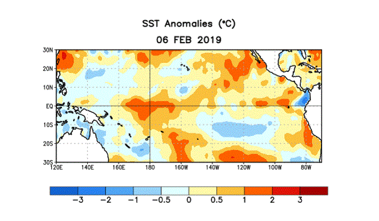
After several months of flirting, the tropical Pacific ocean and atmosphere appear to have coupled just in time for Valentine’s Day and now meet the criteria for El Niño conditions. Is it true love? Time will tell, but forecasters expect weak El Niño conditions to persist through the spring.
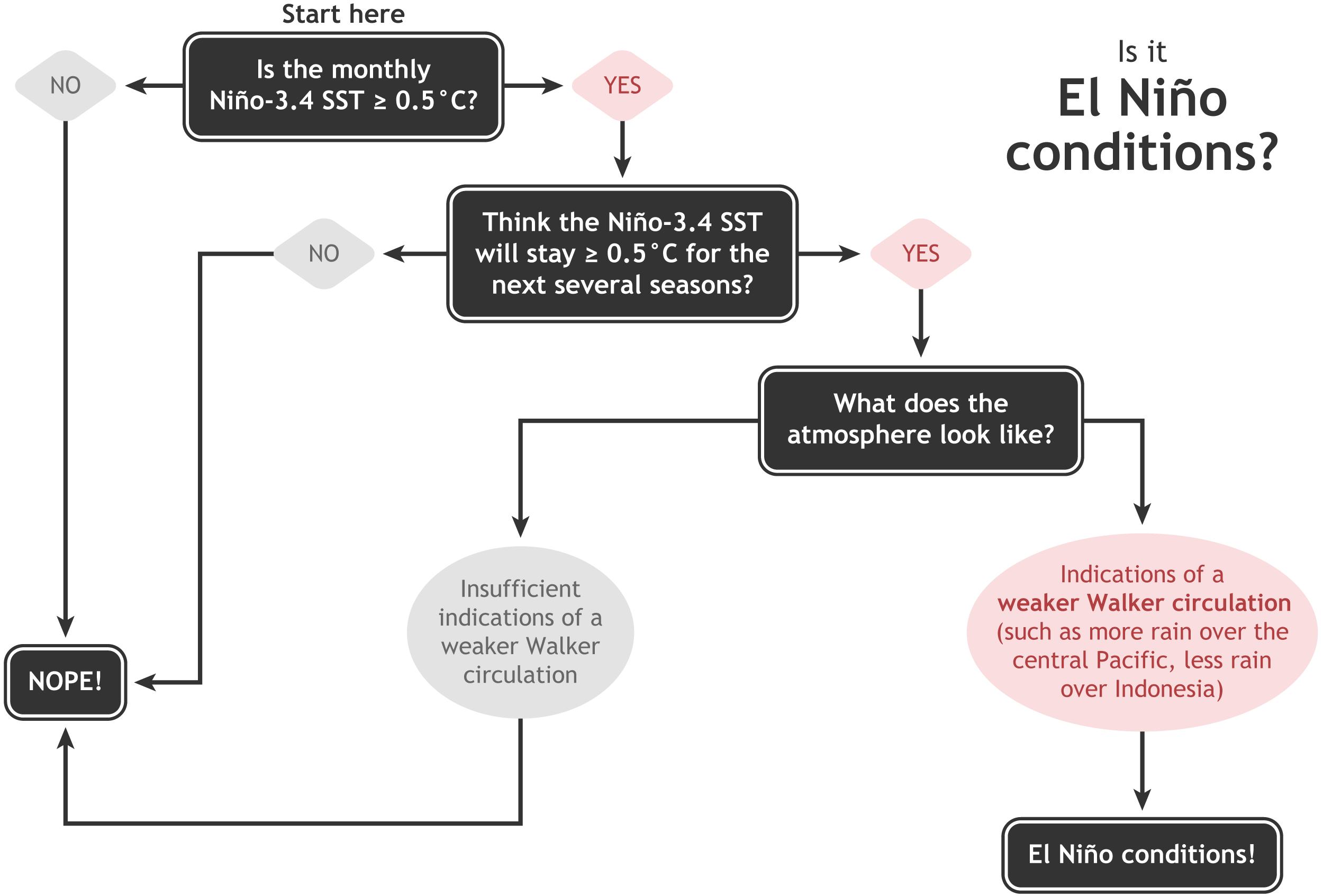 [Summary of decision process in determining El Niño conditions. NOAA Climate drawing by Glen Becker and Fiona Martin.]
That is, the sea surface temperature in the Niño3.4 region of the tropical Pacific Ocean has been more than 0.5°C above the long-term average, and models were predicting it would stay that way for the next several seasons.
[Summary of decision process in determining El Niño conditions. NOAA Climate drawing by Glen Becker and Fiona Martin.]
That is, the sea surface temperature in the Niño3.4 region of the tropical Pacific Ocean has been more than 0.5°C above the long-term average, and models were predicting it would stay that way for the next several seasons.
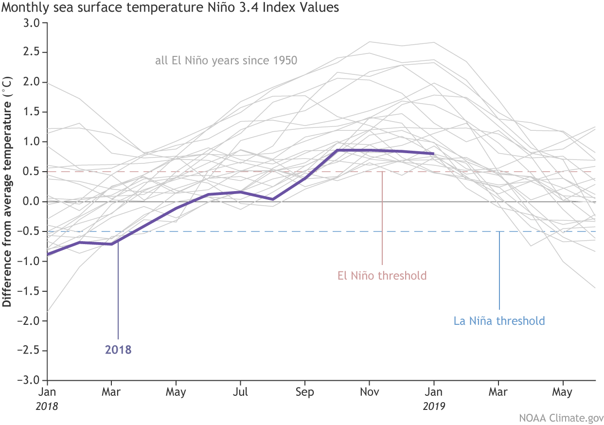 [Monthly sea surface temperature in the Niño 3.4 region of the tropical Pacific for 2018 (purple line) and all other El Niño years since 1950. NOAA Climate graph based on ERSSTv5 temperature data.]
What’s new over the past month is that we’re seeing signs of El Niño-related changes in the atmosphere, with increased clouds and rain in the central Pacific indicating a weaker Walker circulation. One measurement of the strength of the Walker circulation, the Equatorial Southern Oscillation Index, was -0.6 during January, indicating more rising air than average over the eastern Pacific, and less than average over the western Pacific. These changes are enough evidence that the atmosphere is responding to the warmer ocean, leading us to conclude we have El Niño conditions!
[Monthly sea surface temperature in the Niño 3.4 region of the tropical Pacific for 2018 (purple line) and all other El Niño years since 1950. NOAA Climate graph based on ERSSTv5 temperature data.]
What’s new over the past month is that we’re seeing signs of El Niño-related changes in the atmosphere, with increased clouds and rain in the central Pacific indicating a weaker Walker circulation. One measurement of the strength of the Walker circulation, the Equatorial Southern Oscillation Index, was -0.6 during January, indicating more rising air than average over the eastern Pacific, and less than average over the western Pacific. These changes are enough evidence that the atmosphere is responding to the warmer ocean, leading us to conclude we have El Niño conditions!
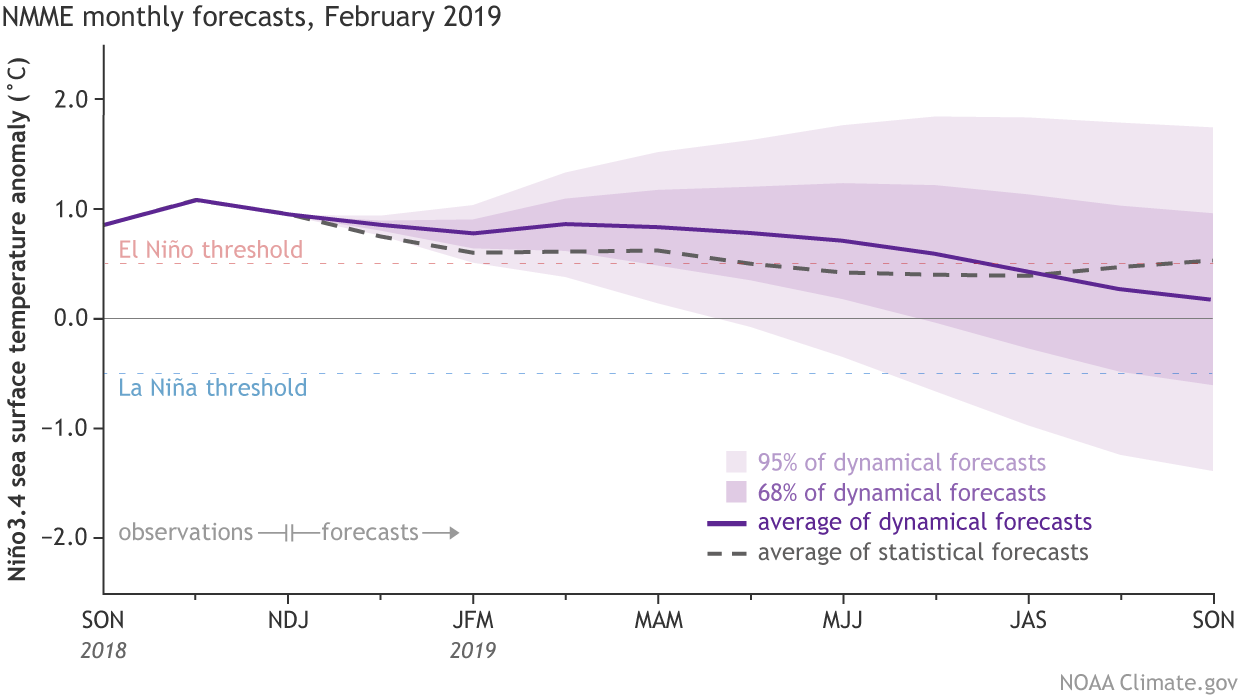 [Climate model forecasts for the Niño3.4 Index. Dynamical model data (purple line) from the North American Multi-Model Ensemble (NMME): darker purple envelope shows the range of 68% of all model forecasts; lighter purple shows the range of 95% of all model forecasts. Statistical model data (dashed line) from CPC’s Consolidated SST Forecasts. NOAA Climate image from CPC data.]
The surface warming in the Niño3.4 region is currently just a few tenths of a degree above the El Niño threshold (0.5°C warmer than average), and actually decreased through January. Most of the climate models predict that the surface temperature anomaly (the difference from the long-term mean) will increase slightly in the near future, and remain above the El Niño threshold through the spring.
Bolstering forecasters’ confidence that short-term surface warming will rebound and then persist for the next few months is the presence of warmer-than-average water below the surface of the Pacific. This blob, a downwelling Kelvin wave, will travel eastward over the next few weeks, gradually rising and providing a source of warmer waters to the surface.
[Climate model forecasts for the Niño3.4 Index. Dynamical model data (purple line) from the North American Multi-Model Ensemble (NMME): darker purple envelope shows the range of 68% of all model forecasts; lighter purple shows the range of 95% of all model forecasts. Statistical model data (dashed line) from CPC’s Consolidated SST Forecasts. NOAA Climate image from CPC data.]
The surface warming in the Niño3.4 region is currently just a few tenths of a degree above the El Niño threshold (0.5°C warmer than average), and actually decreased through January. Most of the climate models predict that the surface temperature anomaly (the difference from the long-term mean) will increase slightly in the near future, and remain above the El Niño threshold through the spring.
Bolstering forecasters’ confidence that short-term surface warming will rebound and then persist for the next few months is the presence of warmer-than-average water below the surface of the Pacific. This blob, a downwelling Kelvin wave, will travel eastward over the next few weeks, gradually rising and providing a source of warmer waters to the surface.
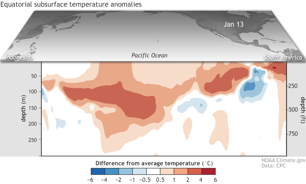 [Departure from average of the surface and subsurface tropical Pacific sea temperature averaged over 5-day periods starting in early June 2018. The vertical axis is depth below the surface (meters) and the horizontal axis is longitude, from the western to eastern tropical Pacific. This cross-section is right along the equator. NOAA Climate figure from CPC data.]
Say yes
For a few months now, the tropical Pacific has met the first two criteria of our “Is It El Niño Conditions?” decision tree.
[Summary of decision process in determining El Niño conditions. NOAA Climate drawing by Glen Becker and Fiona Martin.]
That is, the sea surface temperature in the Niño3.4 region of the tropical Pacific Ocean has been more than 0.5°C above the long-term average, and models were predicting it would stay that way for the next several seasons.
[Monthly sea surface temperature in the Niño 3.4 region of the tropical Pacific for 2018 (purple line) and all other El Niño years since 1950. NOAA Climate graph based on ERSSTv5 temperature data.]
What’s new over the past month is that we’re seeing signs of El Niño-related changes in the atmosphere, with increased clouds and rain in the central Pacific indicating a weaker Walker circulation. One measurement of the strength of the Walker circulation, the Equatorial Southern Oscillation Index, was -0.6 during January, indicating more rising air than average over the eastern Pacific, and less than average over the western Pacific. These changes are enough evidence that the atmosphere is responding to the warmer ocean, leading us to conclude we have El Niño conditions!
Be Mine
The Walker circulation—the atmospheric circulation over the whole tropical Pacific Ocean—is usually driven by intense rising air over the very warm waters of the far western Pacific and Indonesia. This air rises to the upper atmosphere, travels eastward, sinks over the eastern Pacific, and travels back westward near the surface, forming the trade winds. When El Niño’s warmer-than-average surface waters develop in the central-eastern Pacific, the Walker circulation is weakened. The extra heat in the ocean surface warms the air above it, leading to more rising motion, and hence more clouds and rain than average over the central-eastern tropical Pacific. Adding a source of rising air over the central-eastern Pacific, and reducing the rising air over the far western Pacific, means the steady upper-level and near-surface winds are disrupted. Those weaker-than-average near-surface winds in turn help to keep the surface warmer, in a feedback process critical to the coupled system of El Niño.Call me
[Climate model forecasts for the Niño3.4 Index. Dynamical model data (purple line) from the North American Multi-Model Ensemble (NMME): darker purple envelope shows the range of 68% of all model forecasts; lighter purple shows the range of 95% of all model forecasts. Statistical model data (dashed line) from CPC’s Consolidated SST Forecasts. NOAA Climate image from CPC data.]
The surface warming in the Niño3.4 region is currently just a few tenths of a degree above the El Niño threshold (0.5°C warmer than average), and actually decreased through January. Most of the climate models predict that the surface temperature anomaly (the difference from the long-term mean) will increase slightly in the near future, and remain above the El Niño threshold through the spring.
Bolstering forecasters’ confidence that short-term surface warming will rebound and then persist for the next few months is the presence of warmer-than-average water below the surface of the Pacific. This blob, a downwelling Kelvin wave, will travel eastward over the next few weeks, gradually rising and providing a source of warmer waters to the surface.
[Departure from average of the surface and subsurface tropical Pacific sea temperature averaged over 5-day periods starting in early June 2018. The vertical axis is depth below the surface (meters) and the horizontal axis is longitude, from the western to eastern tropical Pacific. This cross-section is right along the equator. NOAA Climate figure from CPC data.]
U R Cute
But what does it all mean? Is this relationship built to last? The future remains to be seen, but forecasters give weak El Niño conditions the edge through the spring. After that, chances of a continued El Niño drop below 50%. It’s tough to make a successful forecast for later in the year, due in large part to the “spring predictability barrier,” a notoriously tricky obstacle for computer models. Spring is a time of year when ENSO (El Niño/Southern Oscillation, the entire El Niño and La Niña system) is often transitioning, making it especially difficult to predict what comes next. Weak El Niño conditions means that El Niño isn’t dominating the global circulation, and there is a lower probability of El Niño-related global temperature and precipitation effects through the next few months. Other players, including the Madden-Julian Oscillation, may continue to affect weather patterns. Edited for WeatherNation by Meteorologist Mace MichaelsAll Weather News
More
Hurricane Flossie Continues to Weaken
Hurricane FlossieThe National Hurricane Cente
3 Jul 2025 2:50 AM

NHC Monitoring Front in the Southeast Ahead of 4th of July
Later this week, a frontal boundary is expect
3 Jul 2025 1:00 AM

Northern Plains to Upper Midwest Severe Storms Threaten Holiday Travel
NORTHERN PLAINS - A frontal system is expecte
3 Jul 2025 1:00 AM


Northwest Heat Met With Thunderstorm Risk
NORTHWEST - Today, portions of Montana are un
3 Jul 2025 12:00 AM

Near Seasonal Temperatures for Many Come July 4th!
AAA is expecting over 70 million travelers to
2 Jul 2025 6:40 PM

Severe Weather Threat Continues in the Midwest
It has been an active, severe season across t
30 Jun 2025 9:00 PM