Fire Weather Concern Shifts Thursday
Top Stories
18 Apr 2018 10:10 PM
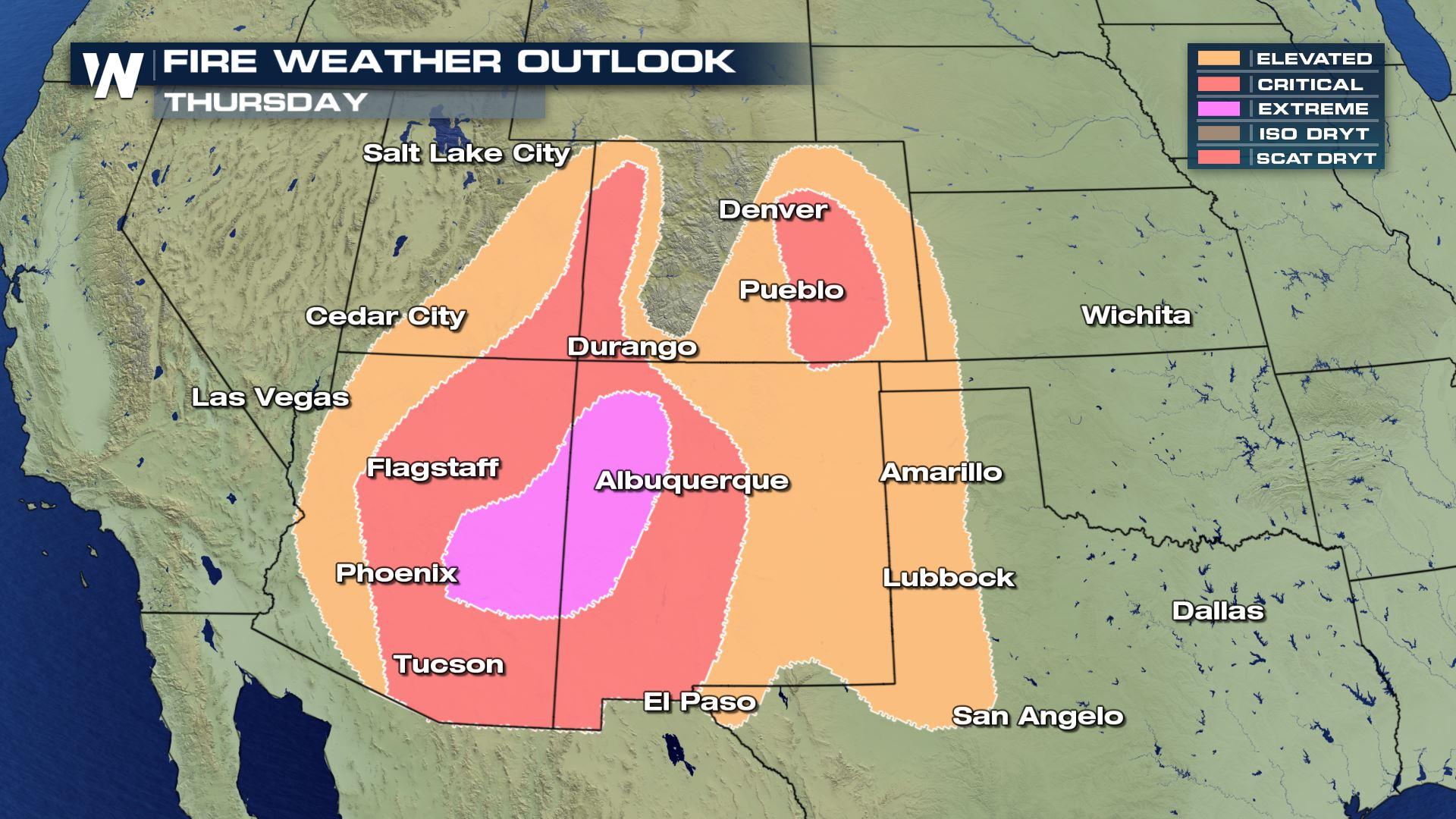
Extreme fire danger moves into the Four Corners Thursday in response to strong wind and low relative humidity levels.
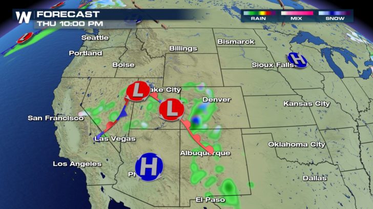
 Fire Weather Outlook valid for Thursday, April 19
An approaching cold front will bring *beneficial rain* to parts of the South and Southwest, but before it arrives it'll kick up the wind and cause the fire concern.
Fire Weather Outlook valid for Thursday, April 19
An approaching cold front will bring *beneficial rain* to parts of the South and Southwest, but before it arrives it'll kick up the wind and cause the fire concern.
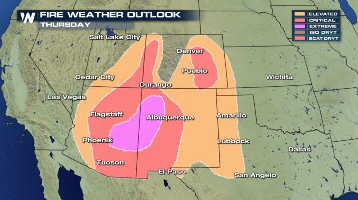
 Fire weather alerts are in effect through at least Thursday, if not into Friday the 20th.
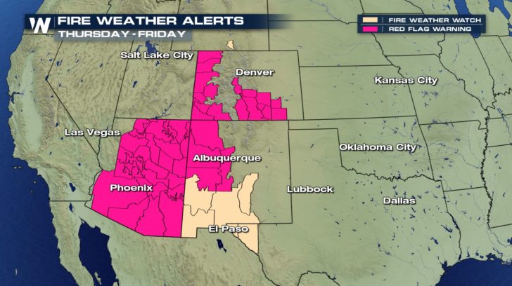
Wind gusts may reach up to 50 miles per hour for the lower elevations and up to 70 mph for the higher elevations Thursday.
Fire weather alerts are in effect through at least Thursday, if not into Friday the 20th.
Wind gusts may reach up to 50 miles per hour for the lower elevations and up to 70 mph for the higher elevations Thursday.
 Wind alerts effective Thursday, April 19th.
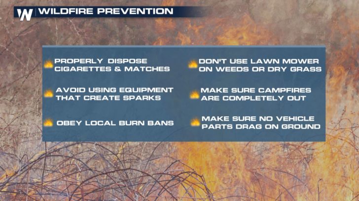 When fire weather alerts are issued, you want to check for local burn bans. These can be found via local governments or your town/municipality. Then, avoid doing yardwork that may create sparks, make sure campfires are all out (if burn bans aren't in effect) and properly dispose of cigarettes and matches.
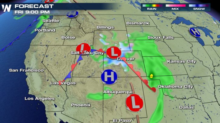
Areas of rain and snow will move across the Four Corners and into the drought-stricken region of Texas/Oklahoma between Thursday and Saturday. Then, up to an inch (maybe even two) may fall on the dry ground, helping to diminish the fire concern (for now).
When fire weather alerts are issued, you want to check for local burn bans. These can be found via local governments or your town/municipality. Then, avoid doing yardwork that may create sparks, make sure campfires are all out (if burn bans aren't in effect) and properly dispose of cigarettes and matches.
Areas of rain and snow will move across the Four Corners and into the drought-stricken region of Texas/Oklahoma between Thursday and Saturday. Then, up to an inch (maybe even two) may fall on the dry ground, helping to diminish the fire concern (for now).
 Forecast Thursday, April 19 where green shows rain and blue shows snow
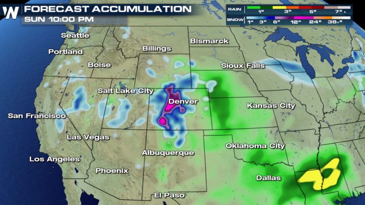 Total rain and snow for the next few days (through Sunday the 22nd)
Keep an eye on the conditions across Utah, Arizona, New Mexico, and Colorado Thursday. We will keep you updated on any developments.
For WeatherNation, Meteorologist Steve Glazier
Total rain and snow for the next few days (through Sunday the 22nd)
Keep an eye on the conditions across Utah, Arizona, New Mexico, and Colorado Thursday. We will keep you updated on any developments.
For WeatherNation, Meteorologist Steve Glazier
Fire Weather Outlook valid for Thursday, April 19
An approaching cold front will bring *beneficial rain* to parts of the South and Southwest, but before it arrives it'll kick up the wind and cause the fire concern.
Fire weather alerts are in effect through at least Thursday, if not into Friday the 20th.
Wind gusts may reach up to 50 miles per hour for the lower elevations and up to 70 mph for the higher elevations Thursday.
Wind alerts effective Thursday, April 19th.
When fire weather alerts are issued, you want to check for local burn bans. These can be found via local governments or your town/municipality. Then, avoid doing yardwork that may create sparks, make sure campfires are all out (if burn bans aren't in effect) and properly dispose of cigarettes and matches.
Areas of rain and snow will move across the Four Corners and into the drought-stricken region of Texas/Oklahoma between Thursday and Saturday. Then, up to an inch (maybe even two) may fall on the dry ground, helping to diminish the fire concern (for now).
Forecast Thursday, April 19 where green shows rain and blue shows snow
Total rain and snow for the next few days (through Sunday the 22nd)
Keep an eye on the conditions across Utah, Arizona, New Mexico, and Colorado Thursday. We will keep you updated on any developments.
For WeatherNation, Meteorologist Steve GlazierAll Weather News
More
Hurricane Flossie Continues to Weaken
Hurricane FlossieThe National Hurricane Cente
3 Jul 2025 2:50 AM

NHC Monitoring Front in the Southeast Ahead of 4th of July
Later this week, a frontal boundary is expect
3 Jul 2025 1:00 AM

Northern Plains to Upper Midwest Severe Storms Threaten Holiday Travel
NORTHERN PLAINS - A frontal system is expecte
3 Jul 2025 1:00 AM


Northwest Heat Met With Thunderstorm Risk
NORTHWEST - Today, portions of Montana are un
3 Jul 2025 12:00 AM

Near Seasonal Temperatures for Many Come July 4th!
AAA is expecting over 70 million travelers to
2 Jul 2025 6:40 PM

Severe Weather Threat Continues in the Midwest
It has been an active, severe season across t
30 Jun 2025 9:00 PM