Downed Powerlines Contributed to Texas Wildfires
Texas A&M Fire Service has been investigating the cause of the large wildfires in the Texas Panhandle as potentially originating from power lines. The cause of the fire is still listed as "under investigation" and WeatherNation is working to confirm that the cause of the fire has been reached. However, below is a statement from Xcel Energy on Thursday, March 7th that acknowledges the part their equipment played in the ignition of the Smokehouse Creek fire but does not acknowledge any negligence at this time. Further, Xcel Energy says that it does not believe its equipment was responsible for the Windy Deuce fire in the Texas Panhandle on the same day. To read the entire statement, click here.
" Xcel Energy has been cooperating with the investigations into the wildfires and has been conducting its own review. Based on currently available information, Xcel Energy acknowledges that its facilities appear to have been involved in an ignition of the Smokehouse Creek fire.
Xcel Energy disputes claims that it acted negligently in maintaining and operating its infrastructure; however, we encourage people who had property destroyed by or livestock lost in the Smokehouse Creek fire to submit a claim to Xcel Energy through our claims process. We will review and respond to any such claims in an expeditious manner, with a priority on claims from any person that lost their home in the Smokehouse Creek fire. A claim form and instructions for submission can be found by visiting www.xcelenergy.com and scrolling to the bottom righthand side of that page, to the "Claims Process" link under Customer Support Claims Services | Customer Support | Xcel Energy.
Xcel Energy notes that the Windy Deuce fire reportedly impacted many structures in and around Fritch, Texas. Xcel does not believe that its facilities caused the ignition of the Windy Deuce fire, and we are not aware of any allegation that Xcel Energy’s facilities caused this fire."
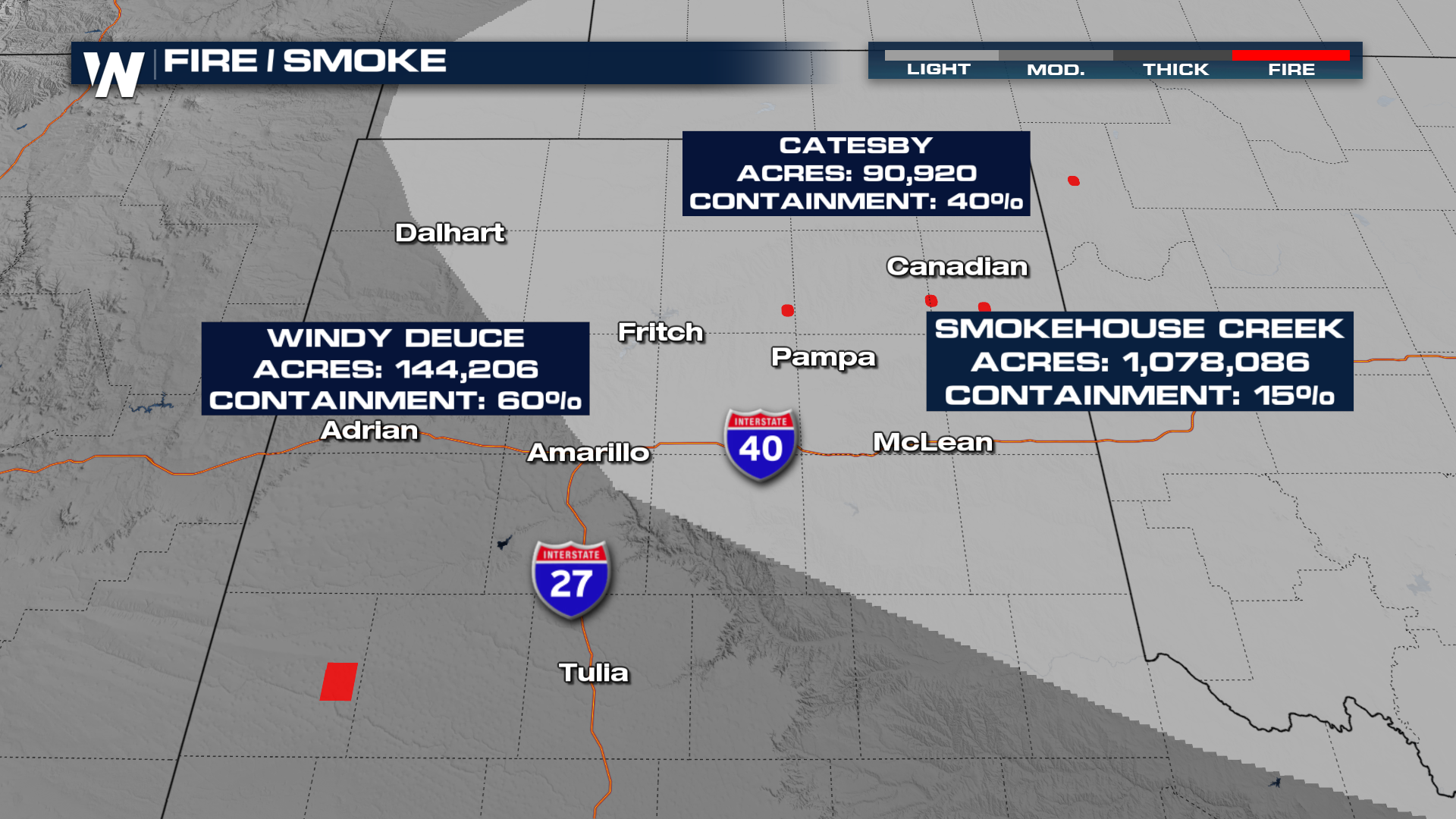
An update on the size and containment of the fires is as follows (current as of Thursday, March 7th):
Smokehouse Creek Fire, Hutchinson County - est. 1,059,570 acres, 74% contained
Windy Deuce Fire, Moore County - 144,206 acres, 89% contained
Grape Vine Creek Fire, Gray County - 34,882 acres, 96% contained
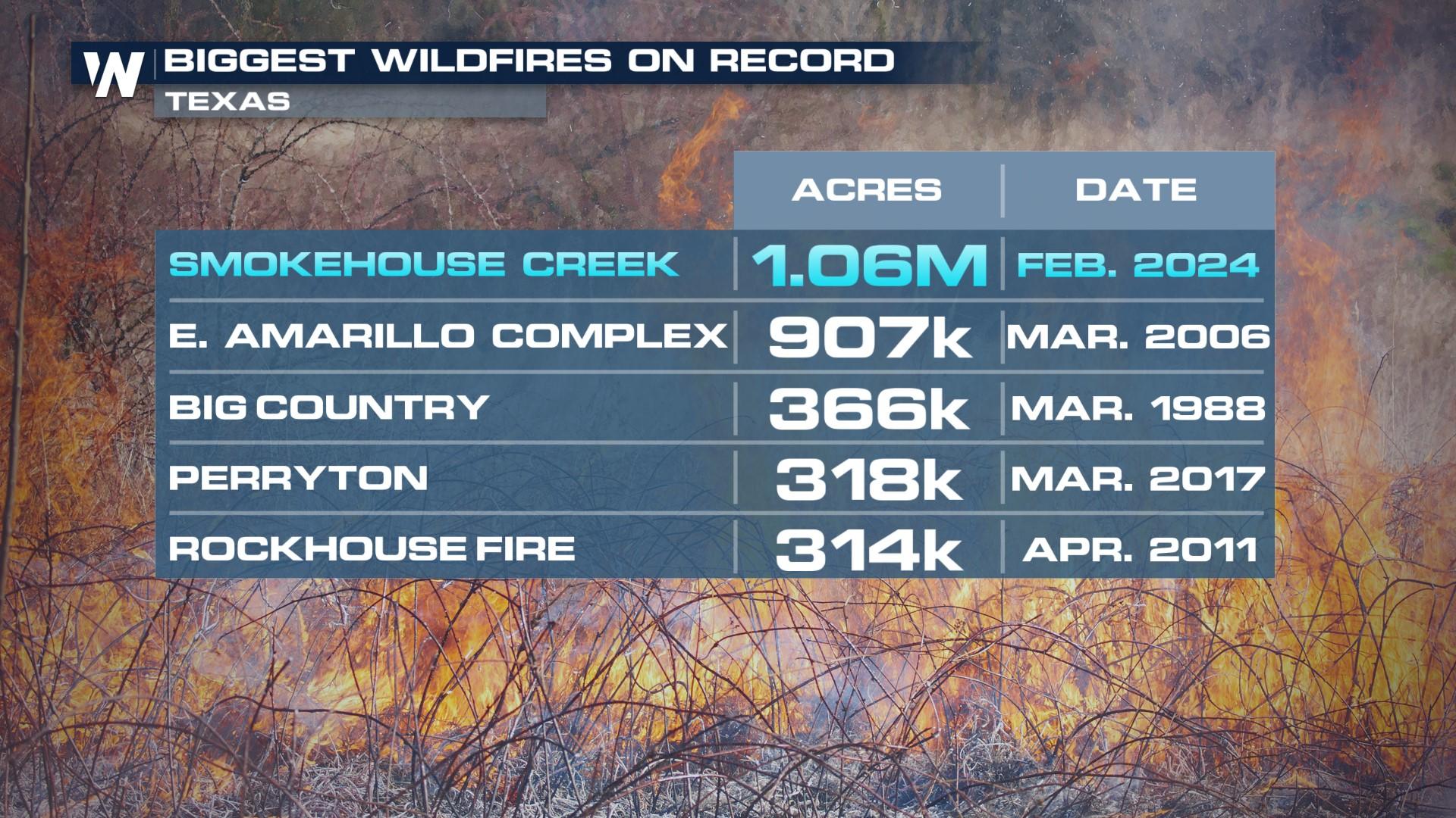
Huge fires broke out on Monday, February 26th in the Texas Panhandle, forcing the evacuation of many small communities north of Amarillo. The Smokehouse Creek fire has grown to 1.075 million acres, now the largest in modern Texas State history. For context, it was 40,000 acres Tuesday morning (2/27), and less than 12 hours later, estimated at 250k. Additional large fires including the Windy Deuce and Catesby Fires started the region as well.
 What Caused This Fire? The cause of this fire remains under investigation. However, the weather conditions all led to wildfire danger on Monday with temperatures in the 80s (average temperatures are in the 50s in late February), low humidity, strong winds, and ongoing drought. It was a recipe for wildfires to get out of control.
A rare FIRE WARNING was issued in the Texas Panhandle. According to the National Weather Service, fires were moving rapidly east at 3 to 5 mph. Though the forward progress of fires has slowed, the damage left behind is immense. Our field correspondent Erik Fox was in Canadian, TX where evacuation orders were issued on Tuesday as the Smokehouse Creek fire blew through. The damage to homes is immense with many burned.
Texas Gov. Greg Abbott issued a disaster declaration for 60 counties in the Lone Star State, as another fire, the Windy Deuce fire, even paused operations at a nuclear weapons facility outside of Amarillo, TX.
Thick smoke from the wildfires in the Texas Panhandle streamed into Oklahoma and Amarillo on Tuesday - Blowing smoke and dust made for locally poor air quality across the southern Plains.
Fire danger was high across the Plains; a fire that broke out near North Platte on Monday forced a state of emergency in Nebraska for Lincoln and Dawson counties and put some communities under evacuation. It is known as the Betty's Way fire, located 8 miles north of North Platte, NE, and quickly grew to 70k+ acres in less than 24 hours. The fire was started by a lawnmower on Monday afternoon, but as of Wednesday had been 80% contained.