‘First Light’ Images from CERES FM6 Earth-Observing Instrument
Special Stories
23 Jan 2018 9:55 AM
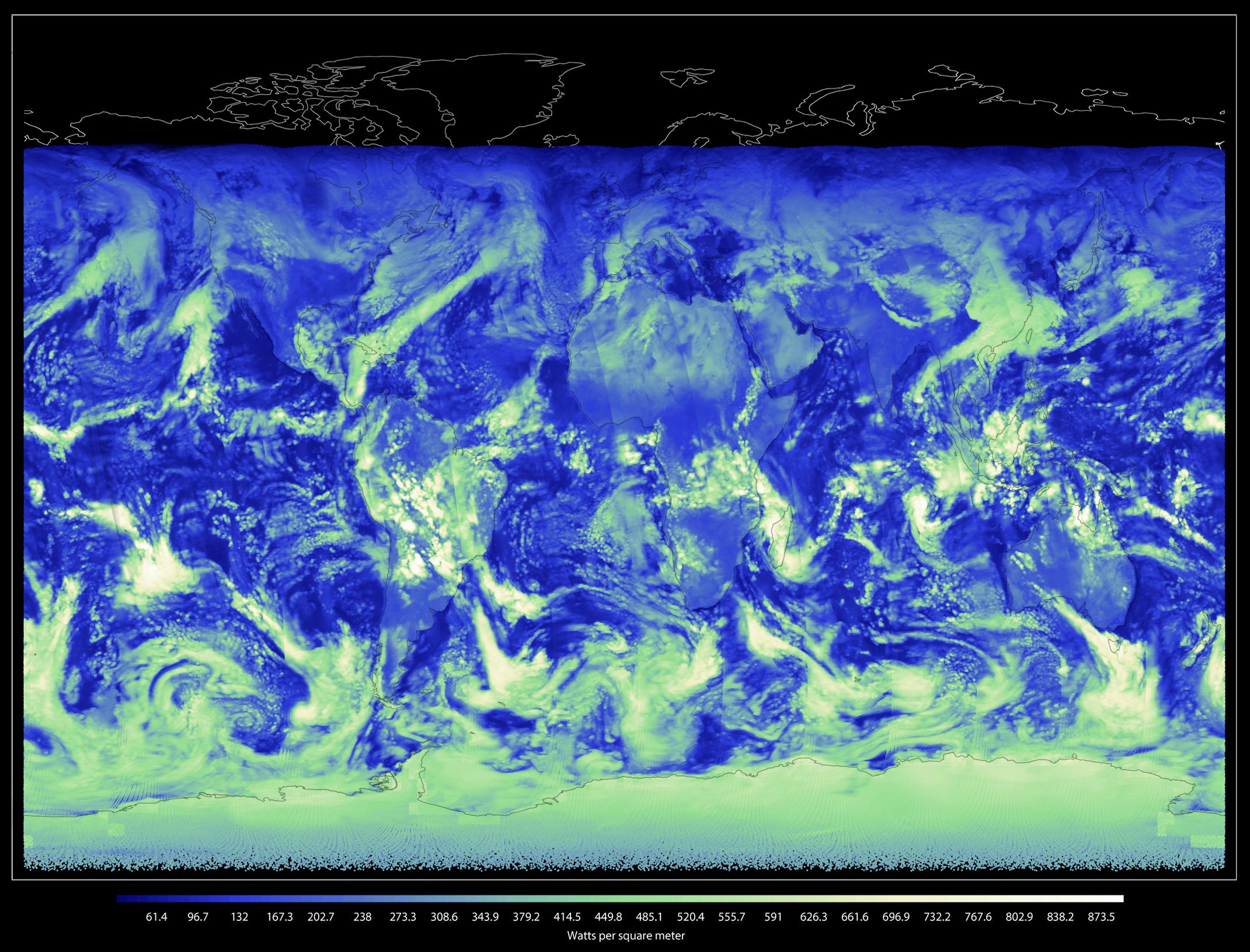
[In this shortwave image from CERES FM6, the white and green shades represent thick cloud cover reflecting incoming solar energy back to space. Compare that with the darker blue regions, which have no cloud cover, to get a sense for just how much clouds can affect the balance of incoming and outgoing energy on Earth. Credits: NASA]
From NASA by Joe Atkinson
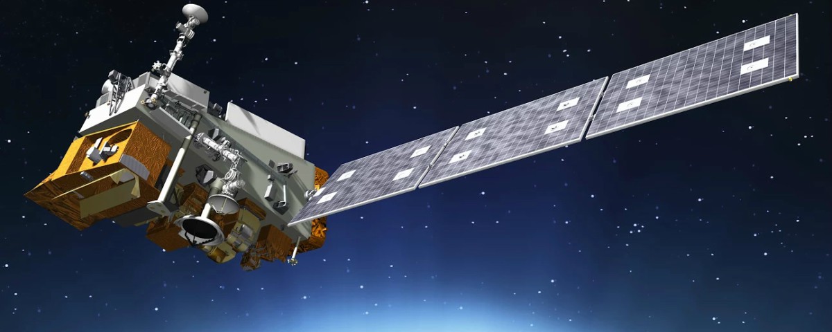
It’s working! The covers on the Clouds and the Earth's Radiant Energy System Flight Model 6 (CERES FM6) opened Jan. 5, allowing it to scan Earth for the first time. The instrument was one of five that launched Nov. 18, on the National Oceanic and Atmospheric Adminstration's (NOAA) Joint Polar Satellite System 1 (JPSS-1). After reaching polar orbit, the satellite became known as NOAA-20.
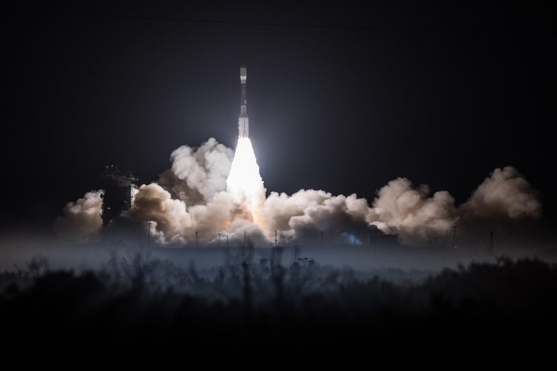 [JPSS-1 liftoff from November 18]
Built by Northrop Grumman, funded by NOAA and managed by NASA's Langley Research Center in Hampton, Virginia, in coordination with the JPSS program, CERES FM6 is the last in a series of instruments going back to the late 1990s that measure the solar energy reflected by Earth, the heat the planet emits, and the role of clouds in that process.
“CERES FM6 is the seventh and final copy since we first launched the first CERES instrument in 1997. It is the most accurate broadband radiometer that NASA/NOAA have flown as a result of a more rigorous prelaunch calibration campaign than previous instruments," said CERES Project Scientist Kory Priestley. "We were able to take knowledge from on-orbit operations and apply it to this flight model. We’ve done a better job of building and characterizing the instrument, and with hope that will bear fruit as the mission is flown.
[JPSS-1 liftoff from November 18]
Built by Northrop Grumman, funded by NOAA and managed by NASA's Langley Research Center in Hampton, Virginia, in coordination with the JPSS program, CERES FM6 is the last in a series of instruments going back to the late 1990s that measure the solar energy reflected by Earth, the heat the planet emits, and the role of clouds in that process.
“CERES FM6 is the seventh and final copy since we first launched the first CERES instrument in 1997. It is the most accurate broadband radiometer that NASA/NOAA have flown as a result of a more rigorous prelaunch calibration campaign than previous instruments," said CERES Project Scientist Kory Priestley. "We were able to take knowledge from on-orbit operations and apply it to this flight model. We’ve done a better job of building and characterizing the instrument, and with hope that will bear fruit as the mission is flown.
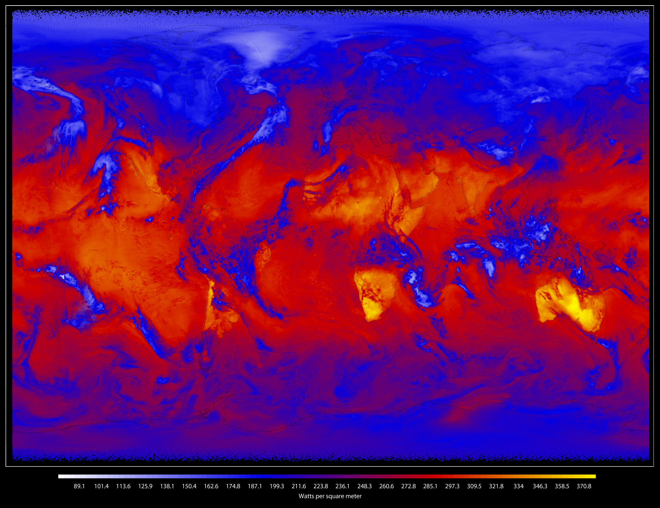 [In this longwave image from CERES FM6, heat energy radiated from Earth is represented by shades of yellow, red, blue and white. Bright yellow regions are the hottest and emit the most energy out to space. Dark blue and bright white regions, which represent clouds, are much colder and emit the least energy. Credits: NASA]
“The robustness of the CERES instruments already on-orbit, having exceeded their design lifetimes by a factor of two to three, is testament to the work of the dedicated team of engineers at Northrop Grumman,” Priestley said. “The scientific discoveries the community will make by utilizing these datasets will benefit humanity for decades to come.”
[In this longwave image from CERES FM6, heat energy radiated from Earth is represented by shades of yellow, red, blue and white. Bright yellow regions are the hottest and emit the most energy out to space. Dark blue and bright white regions, which represent clouds, are much colder and emit the least energy. Credits: NASA]
“The robustness of the CERES instruments already on-orbit, having exceeded their design lifetimes by a factor of two to three, is testament to the work of the dedicated team of engineers at Northrop Grumman,” Priestley said. “The scientific discoveries the community will make by utilizing these datasets will benefit humanity for decades to come.”
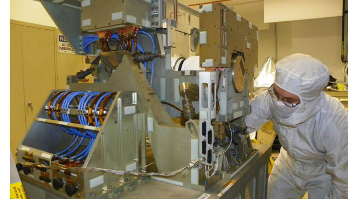 [The Cross-track Infrared Sounder (CrIS), one of five instruments on-board NOAA's Joint Polar Satellite System-1 (JPSS-1) satellite and will provide accurate, detailed atmosphere, temperature, and moisture observations essential for weather forecasting. Credit: Exelis]
Five other CERES instruments are flying on three other satellites. Their data helps scientists validate models that calculate the effect of clouds on planetary heating and cooling. The same data can also be helpful for improving near-term, seasonal forecasts influenced by weather events such as El Niño and La Niña. El Niño and La Niña are climatic fluctuations in the temperature of the tropical Pacific Ocean that can influence weather globally.
"The successful launch of CERES FM6 and acquisition of initial data is fantastic news," said David Considine, program manager for NASA's Modeling, Analysis and Prediction program. "Its data will help us to understand the critical role that clouds play in the Earth system, and shows the value to the Nation of the NASA and NOAA collaboration leading to this achievement."
[The Cross-track Infrared Sounder (CrIS), one of five instruments on-board NOAA's Joint Polar Satellite System-1 (JPSS-1) satellite and will provide accurate, detailed atmosphere, temperature, and moisture observations essential for weather forecasting. Credit: Exelis]
Five other CERES instruments are flying on three other satellites. Their data helps scientists validate models that calculate the effect of clouds on planetary heating and cooling. The same data can also be helpful for improving near-term, seasonal forecasts influenced by weather events such as El Niño and La Niña. El Niño and La Niña are climatic fluctuations in the temperature of the tropical Pacific Ocean that can influence weather globally.
"The successful launch of CERES FM6 and acquisition of initial data is fantastic news," said David Considine, program manager for NASA's Modeling, Analysis and Prediction program. "Its data will help us to understand the critical role that clouds play in the Earth system, and shows the value to the Nation of the NASA and NOAA collaboration leading to this achievement."
 The CERES data record extends back to 1997. Prior to CERES, the Earth Radiation Budget Experiment (ERBE) collected similar data beginning in 1984. The two NASA programs demonstrate NASA’s long-term involvement in measuring Earth's energy balance going back more than 30 years.
“Northrop Grumman is proud to be a collaborative partner with NASA and NOAA on this successful CERES mission. Between the seven CERES instruments and their ERBE predecessors, we have had a relationship in Earth radiation budget measurements that now spans over three decades," said Northrop Grumman CERES Program Manager Sean Kelly. "The CERES instruments continue to reliably provide the climate data record necessary for monitoring, processing and analyzing critical data for the Earth science community. CERES is one of the most highly calibrated, highly reliable instruments on-orbit today."
The CERES data record extends back to 1997. Prior to CERES, the Earth Radiation Budget Experiment (ERBE) collected similar data beginning in 1984. The two NASA programs demonstrate NASA’s long-term involvement in measuring Earth's energy balance going back more than 30 years.
“Northrop Grumman is proud to be a collaborative partner with NASA and NOAA on this successful CERES mission. Between the seven CERES instruments and their ERBE predecessors, we have had a relationship in Earth radiation budget measurements that now spans over three decades," said Northrop Grumman CERES Program Manager Sean Kelly. "The CERES instruments continue to reliably provide the climate data record necessary for monitoring, processing and analyzing critical data for the Earth science community. CERES is one of the most highly calibrated, highly reliable instruments on-orbit today."
[JPSS-1 liftoff from November 18]
Built by Northrop Grumman, funded by NOAA and managed by NASA's Langley Research Center in Hampton, Virginia, in coordination with the JPSS program, CERES FM6 is the last in a series of instruments going back to the late 1990s that measure the solar energy reflected by Earth, the heat the planet emits, and the role of clouds in that process.
“CERES FM6 is the seventh and final copy since we first launched the first CERES instrument in 1997. It is the most accurate broadband radiometer that NASA/NOAA have flown as a result of a more rigorous prelaunch calibration campaign than previous instruments," said CERES Project Scientist Kory Priestley. "We were able to take knowledge from on-orbit operations and apply it to this flight model. We’ve done a better job of building and characterizing the instrument, and with hope that will bear fruit as the mission is flown.
[In this longwave image from CERES FM6, heat energy radiated from Earth is represented by shades of yellow, red, blue and white. Bright yellow regions are the hottest and emit the most energy out to space. Dark blue and bright white regions, which represent clouds, are much colder and emit the least energy. Credits: NASA]
“The robustness of the CERES instruments already on-orbit, having exceeded their design lifetimes by a factor of two to three, is testament to the work of the dedicated team of engineers at Northrop Grumman,” Priestley said. “The scientific discoveries the community will make by utilizing these datasets will benefit humanity for decades to come.”
[The Cross-track Infrared Sounder (CrIS), one of five instruments on-board NOAA's Joint Polar Satellite System-1 (JPSS-1) satellite and will provide accurate, detailed atmosphere, temperature, and moisture observations essential for weather forecasting. Credit: Exelis]
Five other CERES instruments are flying on three other satellites. Their data helps scientists validate models that calculate the effect of clouds on planetary heating and cooling. The same data can also be helpful for improving near-term, seasonal forecasts influenced by weather events such as El Niño and La Niña. El Niño and La Niña are climatic fluctuations in the temperature of the tropical Pacific Ocean that can influence weather globally.
"The successful launch of CERES FM6 and acquisition of initial data is fantastic news," said David Considine, program manager for NASA's Modeling, Analysis and Prediction program. "Its data will help us to understand the critical role that clouds play in the Earth system, and shows the value to the Nation of the NASA and NOAA collaboration leading to this achievement."
The CERES data record extends back to 1997. Prior to CERES, the Earth Radiation Budget Experiment (ERBE) collected similar data beginning in 1984. The two NASA programs demonstrate NASA’s long-term involvement in measuring Earth's energy balance going back more than 30 years.
“Northrop Grumman is proud to be a collaborative partner with NASA and NOAA on this successful CERES mission. Between the seven CERES instruments and their ERBE predecessors, we have had a relationship in Earth radiation budget measurements that now spans over three decades," said Northrop Grumman CERES Program Manager Sean Kelly. "The CERES instruments continue to reliably provide the climate data record necessary for monitoring, processing and analyzing critical data for the Earth science community. CERES is one of the most highly calibrated, highly reliable instruments on-orbit today."All Weather News
More
East Gears Up for Stormy, Wet Weekend
A low pressure system crashing through the Mi
1 Aug 2026 11:35 AM


Flooding, Severe Storms Target the Midwest Again
After an active week of storms across the nor
1 Aug 2026 1:40 AM


After Reaching Category 5, Genevieve Weakens in the Pacific
PacificFausto is now a post-tropical cyclone.
31 Jul 2026 1:30 AM

Flooding Risk Increases as Heavy Rain Targets the Tri-State Area
Tuesday, heavy rainfall moved across the Nort
30 Jul 2026 12:25 AM

Severe Weather: Energy From the Midwest Now in the Southeast
UPPER MIDWEST - Through Monday, dangerous tor
29 Jul 2026 10:30 PM