Five Reasons GOES-S Will be a Game-Changer for Weather Forecasts in the Western U.S.
Special Stories
22 Feb 2018 8:18 AM
From NOAA
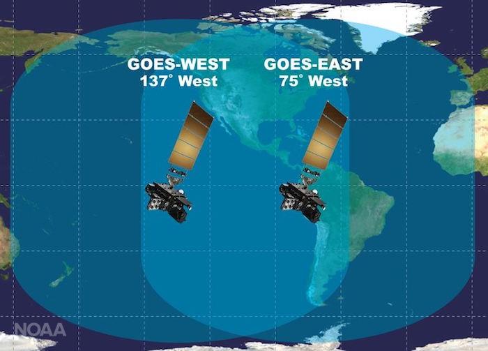
Excitement is building for the launch of GOES-S. On March 1, 2018, NOAA’s newest geostationary satellite will launch into space from Cape Canaveral, Florida. GOES-S (which will become GOES-17 once it reaches its final orbit) will significantly enhance weather forecasting capabilities across the western United States, Alaska, and Hawaii and provide critical data and imagery of the eastern and central Pacific Ocean extending all the way to New Zealand. Here are five reasons why GOES-S will be such a game-changer for weather forecasts from California to Alaska and beyond.
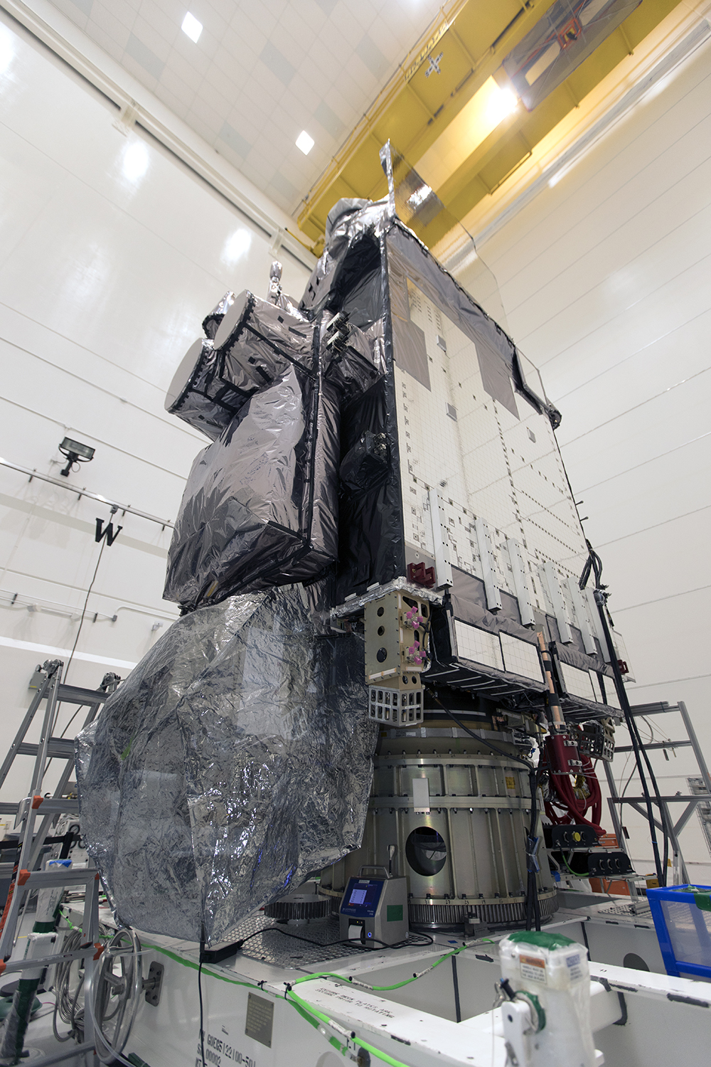 [GOES-S inside Astrotech Space Operations facility in Titusville Florida.]
Our ability to see weather forming over the Pacific Ocean has been hampered by a lack of high-quality data. Data coverage is sparse over the northeastern Pacific, where many weather systems that affect the continental U.S. are born. The improved technology aboard GOES-S will provide valuable new data about upper level wind conditions. This data then gets fed into computer models used by forecasters at the National Weather Service.
Like GOES-16 (now NOAA’s GOES East satellite), GOES-S will collect three times more data at four times better resolution, and scan the Earth five times faster than previous geostationary satellites over western North America, providing far more information to the models used to make those five-day forecasts we’re so familiar with.
[GOES-S inside Astrotech Space Operations facility in Titusville Florida.]
Our ability to see weather forming over the Pacific Ocean has been hampered by a lack of high-quality data. Data coverage is sparse over the northeastern Pacific, where many weather systems that affect the continental U.S. are born. The improved technology aboard GOES-S will provide valuable new data about upper level wind conditions. This data then gets fed into computer models used by forecasters at the National Weather Service.
Like GOES-16 (now NOAA’s GOES East satellite), GOES-S will collect three times more data at four times better resolution, and scan the Earth five times faster than previous geostationary satellites over western North America, providing far more information to the models used to make those five-day forecasts we’re so familiar with.
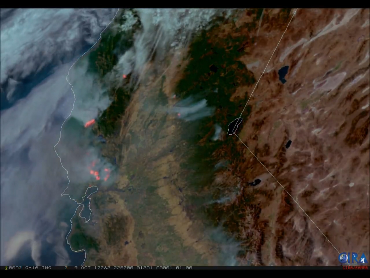 [GOES-16 GeoColor and fire temperature RGB (red-green-blue) imagery of the
wildfires raging in California on October 9, 2017. (Credit: CIRA)]
Thanks to high-resolution imagery from GOES-16, including red-green-blue thermal infrared imagery used to detect fire hot spots, forecasters at the National Weather Service were able to locate fires more quickly, and coordinate warnings with local emergency managers that helped save lives. In some cases, satellite imagery helped detect fires before 911 calls began to come in. GOES-S will provide a “second set of eyes” over the western U.S., and provide new wildfire monitoring capabilities where it is currently lacking, especially in Alaska.
[GOES-16 GeoColor and fire temperature RGB (red-green-blue) imagery of the
wildfires raging in California on October 9, 2017. (Credit: CIRA)]
Thanks to high-resolution imagery from GOES-16, including red-green-blue thermal infrared imagery used to detect fire hot spots, forecasters at the National Weather Service were able to locate fires more quickly, and coordinate warnings with local emergency managers that helped save lives. In some cases, satellite imagery helped detect fires before 911 calls began to come in. GOES-S will provide a “second set of eyes” over the western U.S., and provide new wildfire monitoring capabilities where it is currently lacking, especially in Alaska.
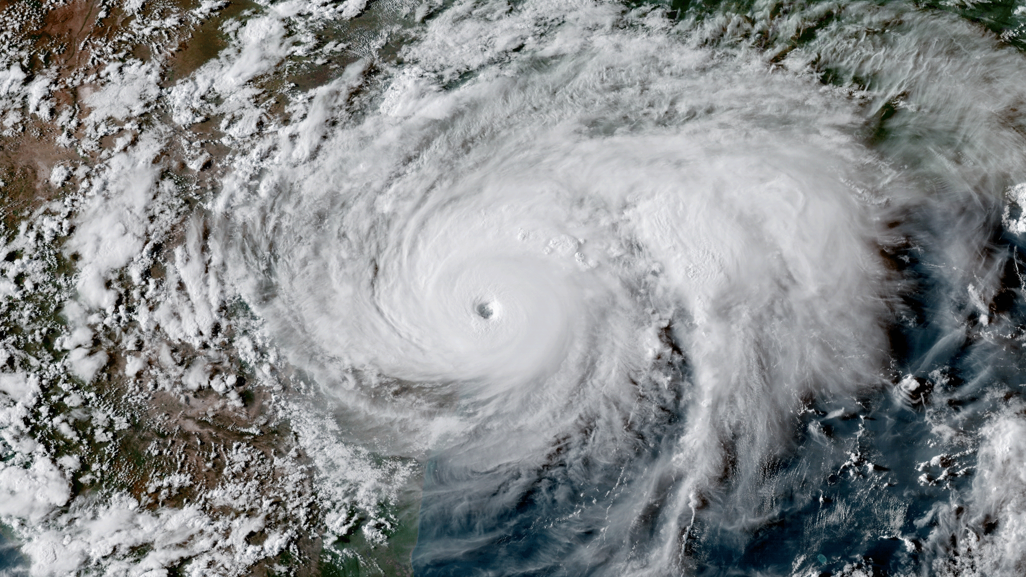 [GOES-16 imagery of Hurricane Harvey making landfall in Texas on August 25, 2017. (NOAA)]
GOES-S will be equipped with an infrared channel that helps forecasters monitor cloud top temperatures, which are used to predict rainfall intensity and the potential for flash flooding or thunderstorms. The Advanced Baseline Imager on GOES-S will have three water vapor bands, two more than GOES-15, NOAA’s current geostationary satellite over the Pacific. These additional channels will provide high resolution imagery of atmospheric water vapor, allowing forecasters to track the movement of major storms and pinpoint areas that will receive the heaviest precipitation.
GOES-S will also have the capability of collecting one-minute imagery over tropical cyclones, which can help forecasters better locate a storm’s center of circulation. In addition, the satellite’s Geostationary Lightning Mapper (GLM) will provide forecasters with near real-time data on a storm’s lightning activity, helping them identify the most convectively active portions of the storm.
[GOES-16 imagery of Hurricane Harvey making landfall in Texas on August 25, 2017. (NOAA)]
GOES-S will be equipped with an infrared channel that helps forecasters monitor cloud top temperatures, which are used to predict rainfall intensity and the potential for flash flooding or thunderstorms. The Advanced Baseline Imager on GOES-S will have three water vapor bands, two more than GOES-15, NOAA’s current geostationary satellite over the Pacific. These additional channels will provide high resolution imagery of atmospheric water vapor, allowing forecasters to track the movement of major storms and pinpoint areas that will receive the heaviest precipitation.
GOES-S will also have the capability of collecting one-minute imagery over tropical cyclones, which can help forecasters better locate a storm’s center of circulation. In addition, the satellite’s Geostationary Lightning Mapper (GLM) will provide forecasters with near real-time data on a storm’s lightning activity, helping them identify the most convectively active portions of the storm.
 [Credit: NOAA]
If you’re a frequent flyer, you’ve probably run into a few travel headaches because fog or low stratus clouds grounded your flight. Luckily, NOAA’s GOES satellites can help mitigate flight delays. In March 2017, data and imagery from GOES-16 helped air traffic controllers at San Francisco International Airport lift a ground delay due to fog. Forecasters were able to use the satellite’s high-resolution imagery to predict when the fog would start to erode, a decision that freed up 32 flights, prevented more than 20 hours of flight delays, and saved the airlines nearly $100,000. Fog monitoring from GOES-S will also improve forecasts used by the maritime sector, such the fishing and commercial shipping industries.
[Credit: NOAA]
If you’re a frequent flyer, you’ve probably run into a few travel headaches because fog or low stratus clouds grounded your flight. Luckily, NOAA’s GOES satellites can help mitigate flight delays. In March 2017, data and imagery from GOES-16 helped air traffic controllers at San Francisco International Airport lift a ground delay due to fog. Forecasters were able to use the satellite’s high-resolution imagery to predict when the fog would start to erode, a decision that freed up 32 flights, prevented more than 20 hours of flight delays, and saved the airlines nearly $100,000. Fog monitoring from GOES-S will also improve forecasts used by the maritime sector, such the fishing and commercial shipping industries.
 [Current geostationary satellite coverage of Alaska, such as this recent GOES-15 visible imagery, will be replaced by high-resolution imagery in 16 different channels. (NOAA)]
This vast new coverage will revolutionize forecasting in Alaska. For example, thanks to combinable image channels on GOES-S (known as “multispectral imagery”), forecasters will be able to distinguish between clouds, snow-covered ground, and sea ice around Alaska’s coasts. This will improve aviation and shipping forecasts, since current GOES visible satellite imagery can’t easily differentiate clouds and snow - a particular challenge during Alaska’s long, dark winter months.
Like its sister satellite, GOES-16, GOES-S will be able to detect hazards often experienced in Alaska, such as wildfires and volcanic ash. Monitoring wildfires using satellite data and imagery will save property and lives, while volcanic ash detection will make air travel significantly safer in a state where flying is the only mode of transport in many remote areas.
Edited for WeatherNation by Meteorologist Mace Michaels
[Current geostationary satellite coverage of Alaska, such as this recent GOES-15 visible imagery, will be replaced by high-resolution imagery in 16 different channels. (NOAA)]
This vast new coverage will revolutionize forecasting in Alaska. For example, thanks to combinable image channels on GOES-S (known as “multispectral imagery”), forecasters will be able to distinguish between clouds, snow-covered ground, and sea ice around Alaska’s coasts. This will improve aviation and shipping forecasts, since current GOES visible satellite imagery can’t easily differentiate clouds and snow - a particular challenge during Alaska’s long, dark winter months.
Like its sister satellite, GOES-16, GOES-S will be able to detect hazards often experienced in Alaska, such as wildfires and volcanic ash. Monitoring wildfires using satellite data and imagery will save property and lives, while volcanic ash detection will make air travel significantly safer in a state where flying is the only mode of transport in many remote areas.
Edited for WeatherNation by Meteorologist Mace Michaels
1. Better, faster data means more reliable forecasts
You may not realize it when you check your favorite weather website or smartphone app for a forecast in, say, San Francisco or Las Vegas, but weather forecasts in the western U.S. are overdue for an upgrade. A reliable forecast - whether it’s for sunny skies, or a serious hazard such as flash floods or tropical cyclones - requires accurate and timely data, and that’s where weather satellites like GOES-S come into play.
[GOES-S inside Astrotech Space Operations facility in Titusville Florida.]
Our ability to see weather forming over the Pacific Ocean has been hampered by a lack of high-quality data. Data coverage is sparse over the northeastern Pacific, where many weather systems that affect the continental U.S. are born. The improved technology aboard GOES-S will provide valuable new data about upper level wind conditions. This data then gets fed into computer models used by forecasters at the National Weather Service.
Like GOES-16 (now NOAA’s GOES East satellite), GOES-S will collect three times more data at four times better resolution, and scan the Earth five times faster than previous geostationary satellites over western North America, providing far more information to the models used to make those five-day forecasts we’re so familiar with.
2. Tracking Wildfires
The arid climate of the western United States makes the region especially vulnerable to wildfires. In 2017, several catastrophic wildfires in California burned more than one million acres of land across the state.
[GOES-16 GeoColor and fire temperature RGB (red-green-blue) imagery of the
wildfires raging in California on October 9, 2017. (Credit: CIRA)]
Thanks to high-resolution imagery from GOES-16, including red-green-blue thermal infrared imagery used to detect fire hot spots, forecasters at the National Weather Service were able to locate fires more quickly, and coordinate warnings with local emergency managers that helped save lives. In some cases, satellite imagery helped detect fires before 911 calls began to come in. GOES-S will provide a “second set of eyes” over the western U.S., and provide new wildfire monitoring capabilities where it is currently lacking, especially in Alaska.
3. Monitoring ‘Atmospheric Rivers’ and Pacific Tropical Cyclones
If you live on the West Coast, you may have heard the term “atmospheric river” or the “pineapple express.” Like rivers in the sky, these narrow conveyor belts of moisture transport huge amounts of water vapor from the subtropics to the west coast of the continental U.S. Strong atmospheric rivers can deliver enormous amounts of rain and high-elevation snow in California and the Pacific Northwest, especially during the winter months. Like GOES-16, which provided groundbreaking new data and imagery during the severe 2017 Atlantic hurricane season, GOES-S will bring this same new technology to the Pacific Ocean. This means forecasters will have new high-resolution imagery of atmospheric rivers, as well as Pacific hurricanes that track toward Hawaii or Mexico during the summer and autumn.
[GOES-16 imagery of Hurricane Harvey making landfall in Texas on August 25, 2017. (NOAA)]
GOES-S will be equipped with an infrared channel that helps forecasters monitor cloud top temperatures, which are used to predict rainfall intensity and the potential for flash flooding or thunderstorms. The Advanced Baseline Imager on GOES-S will have three water vapor bands, two more than GOES-15, NOAA’s current geostationary satellite over the Pacific. These additional channels will provide high resolution imagery of atmospheric water vapor, allowing forecasters to track the movement of major storms and pinpoint areas that will receive the heaviest precipitation.
GOES-S will also have the capability of collecting one-minute imagery over tropical cyclones, which can help forecasters better locate a storm’s center of circulation. In addition, the satellite’s Geostationary Lightning Mapper (GLM) will provide forecasters with near real-time data on a storm’s lightning activity, helping them identify the most convectively active portions of the storm.
4. Fog Detection
You don’t have to live on the West Coast to know that coastal fog is a hallmark weather event in places like San Francisco and parts of the Pacific Northwest. Not only will GOES-S provide high-resolution, real-time imagery of fog conditions, but the satellite’s rapid scanning capabilities will also help forecasters predict when fog will clear.
[Credit: NOAA]
If you’re a frequent flyer, you’ve probably run into a few travel headaches because fog or low stratus clouds grounded your flight. Luckily, NOAA’s GOES satellites can help mitigate flight delays. In March 2017, data and imagery from GOES-16 helped air traffic controllers at San Francisco International Airport lift a ground delay due to fog. Forecasters were able to use the satellite’s high-resolution imagery to predict when the fog would start to erode, a decision that freed up 32 flights, prevented more than 20 hours of flight delays, and saved the airlines nearly $100,000. Fog monitoring from GOES-S will also improve forecasts used by the maritime sector, such the fishing and commercial shipping industries.
5. Special mention: A major upgrade for Alaska
GOES-S will boost weather prediction all across the western U.S., but the new satellite will be especially valuable to Alaska. That’s because NOAA’s current geostationary satellites lack sufficient resolution in regions near the Arctic. GOES-S, however, will provide a significantly clearer view of the Last Frontier - all the way to Alaska’s North Slope, and allow for applications such as tracking sea ice.
[Current geostationary satellite coverage of Alaska, such as this recent GOES-15 visible imagery, will be replaced by high-resolution imagery in 16 different channels. (NOAA)]
This vast new coverage will revolutionize forecasting in Alaska. For example, thanks to combinable image channels on GOES-S (known as “multispectral imagery”), forecasters will be able to distinguish between clouds, snow-covered ground, and sea ice around Alaska’s coasts. This will improve aviation and shipping forecasts, since current GOES visible satellite imagery can’t easily differentiate clouds and snow - a particular challenge during Alaska’s long, dark winter months.
Like its sister satellite, GOES-16, GOES-S will be able to detect hazards often experienced in Alaska, such as wildfires and volcanic ash. Monitoring wildfires using satellite data and imagery will save property and lives, while volcanic ash detection will make air travel significantly safer in a state where flying is the only mode of transport in many remote areas.
Edited for WeatherNation by Meteorologist Mace MichaelsAll Weather News
More
Severe Storms in the Midwest Could Dampen Holiday Plans
NORTHERN PLAINS - A frontal system is expecte
4 Jul 2025 3:20 AM

Near Seasonal Temperatures for Many Come July 4th!
AAA is expecting over 70 million travelers to
4 Jul 2025 3:15 AM

NHC Monitoring Front in the Southeast Ahead of 4th of July
Tropical downpours for a long holiday weekend
4 Jul 2025 3:10 AM

Flossie is No More, Eastern Pacific Remains Active
Post Tropical FlossieThe National Hurricane C
4 Jul 2025 3:05 AM


Northwest Heat Met With Thunderstorm Risk
NORTHWEST - Today, portions of Montana are un
3 Jul 2025 12:00 AM

Severe Weather Threat Continues in the Midwest
It has been an active, severe season across t
30 Jun 2025 9:00 PM