Flood Emergency Issued In Mississippi
Special Stories
1 Jul 2020 10:42 AM
Residents in northern Mississippi were alerted of quickly-rising water after several inches of rain fell in a short amount of time early Wednesday. *Note* the tweet below is from earlier. For the latest info, visit NWS Memphis.
https://twitter.com/NWSMemphis/status/1278331689328992257
A flash flood emergency was issued for counties in northeast Mississippi by the National Weather Service office in Memphis, TN, in effect until 12:15 p.m. CT Wednesday. A flash flood emergency is the most serious of flood alerts. It means that there is confirmation of high water and people within a warning such as this should take immediate action to avoid high/rising water. This warning was a PDS alert, short for Particularly Dangerous Situation, reserved for the most serious of weather alerts.
https://twitter.com/WeatherNation/status/1278342848878796800
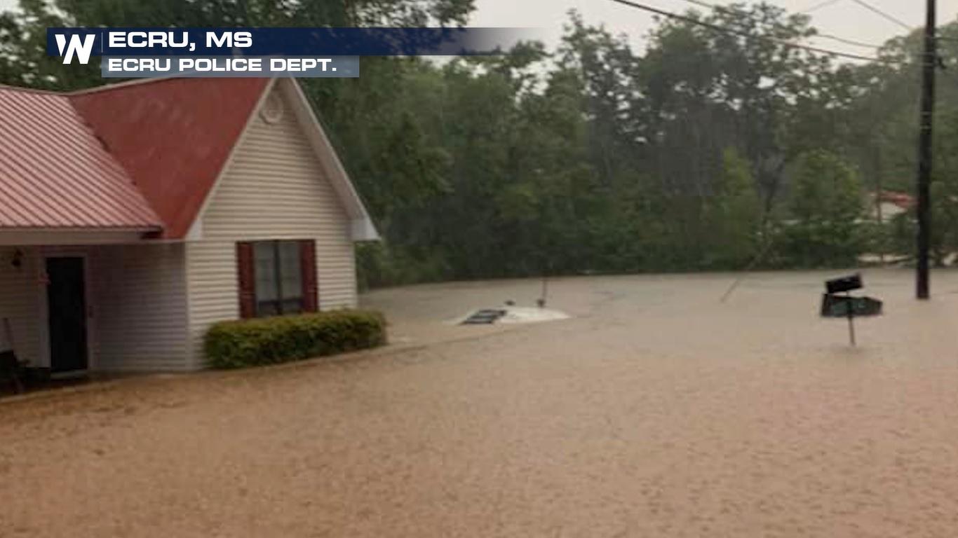
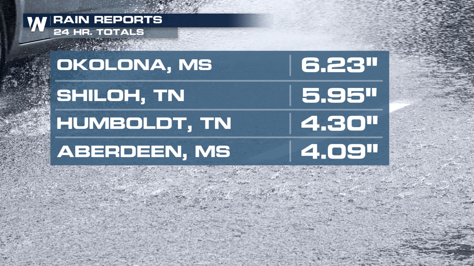
The video above shows high water across Ecru, Mississippi which was one of the cities included in the flash flood emergency. The video is courtesy Willie Mounce via Facebook. Ecru is a small town in northeastern Mississippi east of Oxford and west of Tupelo. Ecru is in Pontotoc County and has a population of about a thousand people. A nearby weather station recorded 6.23" of rainfall as of Wednesday morning, located in Okolona, MS. To put this into perspective, nearby Tupelo gets about 4" of rain for the month of July. In fact, July is typically the 10th-driest month of the year (on average).
It wasn't just Mississippi getting the heavy rain Wednesday.
https://twitter.com/WeatherNation/status/1278331625806286850
The video above shows high water across Selmer, TN from @wbbj7JoshR on Twitter. Selmer is in McNairy County, Tennessee and has a population of about 4,500 people. A nearby weather station in Shiloh, TN reigstered 5.95" of rainfall as of Wednesday morning (24-hour total). McNairy County, TN issued a State of Emergency due to the flash flooding.
 If you are ever within a flash flood warning or emergency, remember to avoid high and rising water. Get away from low water crossings, streams, creeks, urban areas, highways, streets and underpasses because water can collect and rise quickly in these areas!
Related Story: Flood Risk Over The Next Few Days
The flash flooding was due, in part, to a very moist atmosphere in the Southeast along with energy in the atmosphere helping to create and sustain these heavy thunderstorms.
Some additional heavy rain is possible through Wednesday evening. Continue to stay with us here at WeatherNation as we bring you the very latest information and forecast.
If you are ever within a flash flood warning or emergency, remember to avoid high and rising water. Get away from low water crossings, streams, creeks, urban areas, highways, streets and underpasses because water can collect and rise quickly in these areas!
Related Story: Flood Risk Over The Next Few Days
The flash flooding was due, in part, to a very moist atmosphere in the Southeast along with energy in the atmosphere helping to create and sustain these heavy thunderstorms.
Some additional heavy rain is possible through Wednesday evening. Continue to stay with us here at WeatherNation as we bring you the very latest information and forecast.All Weather News
More
Strong July Trough Shakes Up Temperatures
"Enough of this heat, already" - everybodyIn
14 Jul 2025 8:00 PM

Flash Flooding Threat Continues in Texas
It has been 10 days since the devastating flo
14 Jul 2025 7:05 PM

Invest 93L Develops Off Florida Coast, CSU Updates Seasonal Forecast
Invest 93L has developed off the Florida coas
14 Jul 2025 7:00 PM

Flooding Concern Growing in the Northeast
Storms rumbling through the northeast on Sund
14 Jul 2025 6:55 PM

Dangerous Heat Impacting the Western U.S.
High pressure is moving off the California co
14 Jul 2025 6:10 PM

Heavy Rain, Flooding Threat Returns to Florida
Keep the rain boots handy in Florida - heavy
13 Jul 2025 12:50 PM

Severe Storm Risk Pushes into the Great Lakes, Ohio Valley
Friday was another busy day with severe weath
12 Jul 2025 8:00 PM