Major Early-Season Snow Hits Northwest U.S.
Special Stories
28 Sep 2019 9:35 AM
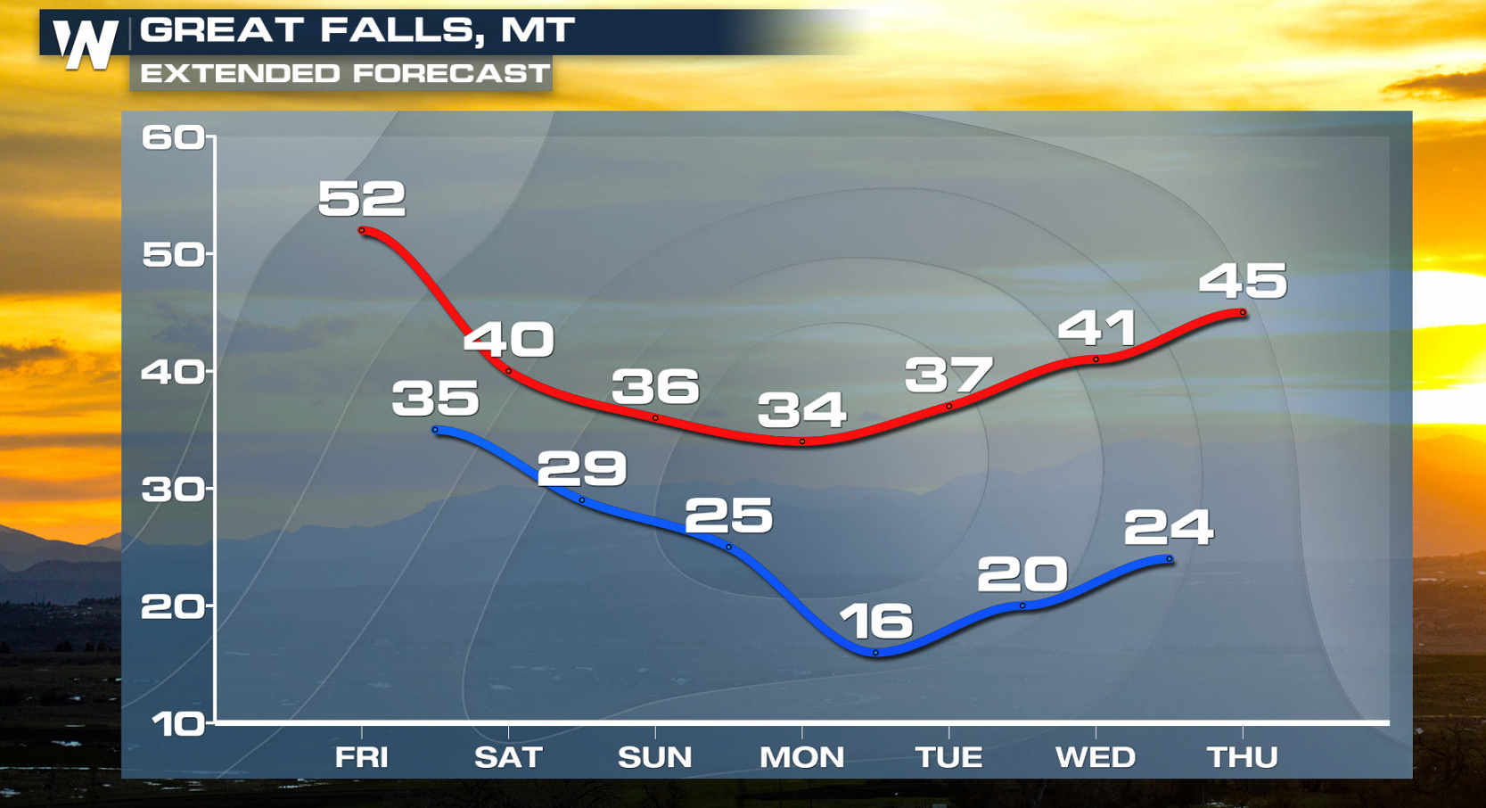
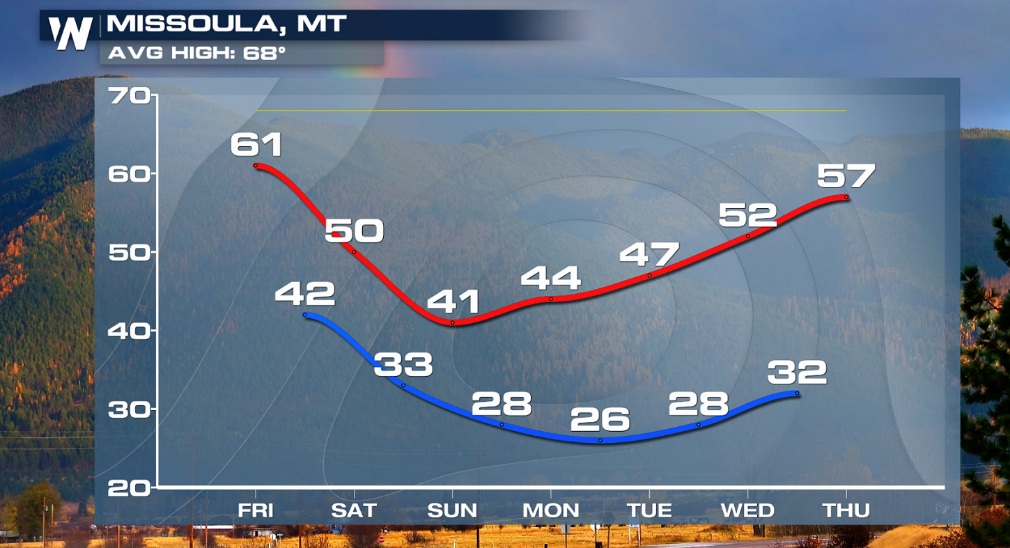
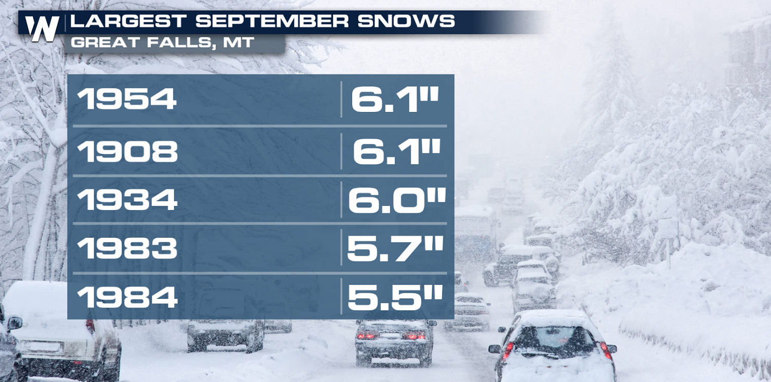
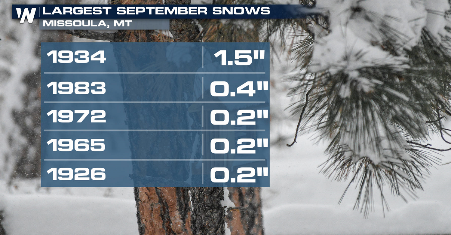
The Northern Rockies are no stranger to big winter storms. However, an early season snow impacting the high country continues to bring widespread and historic impacts. According to the National Weather Service in Great Falls, MT, a fall storm like this hasn't hit this region since 1934.
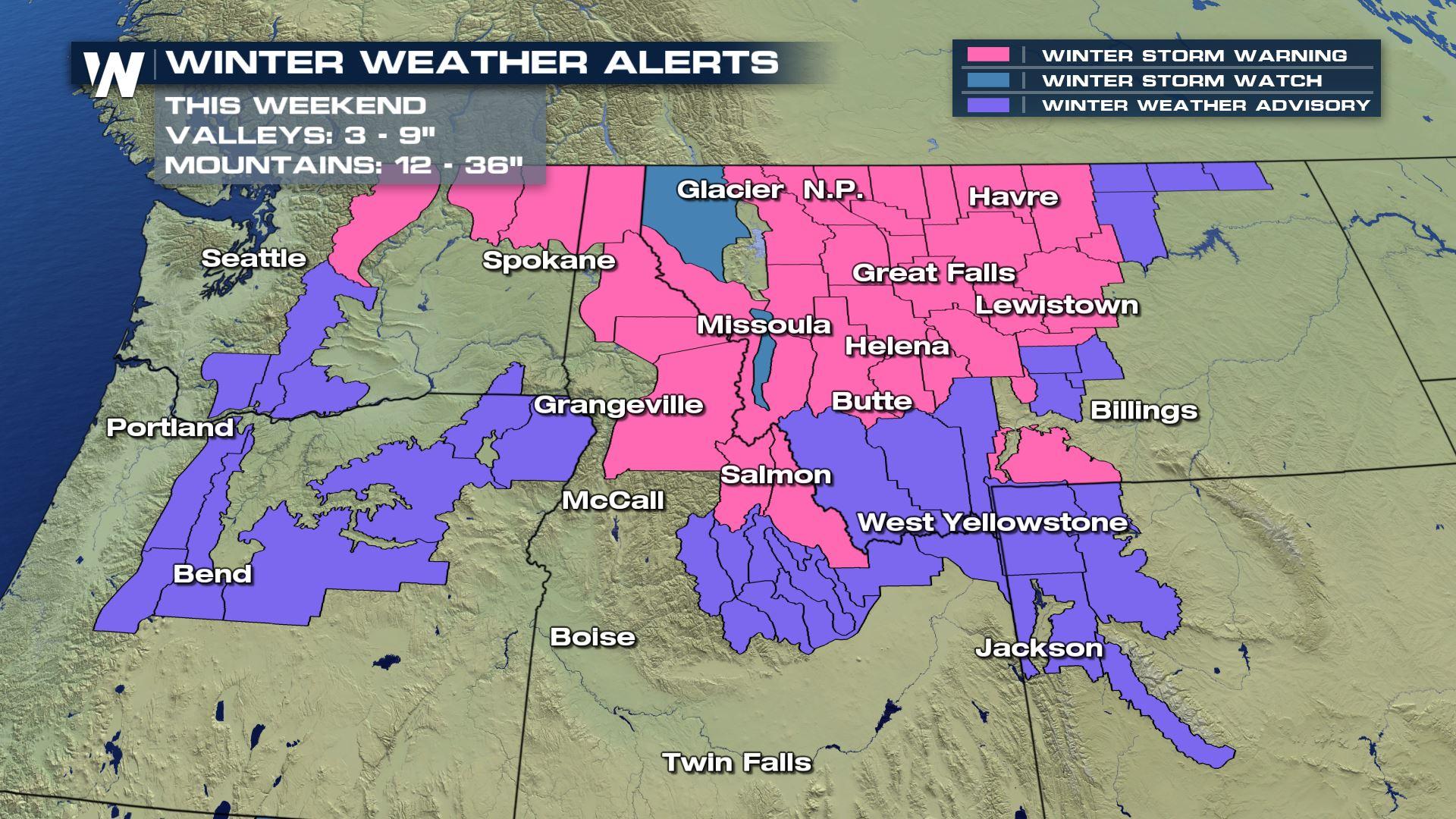
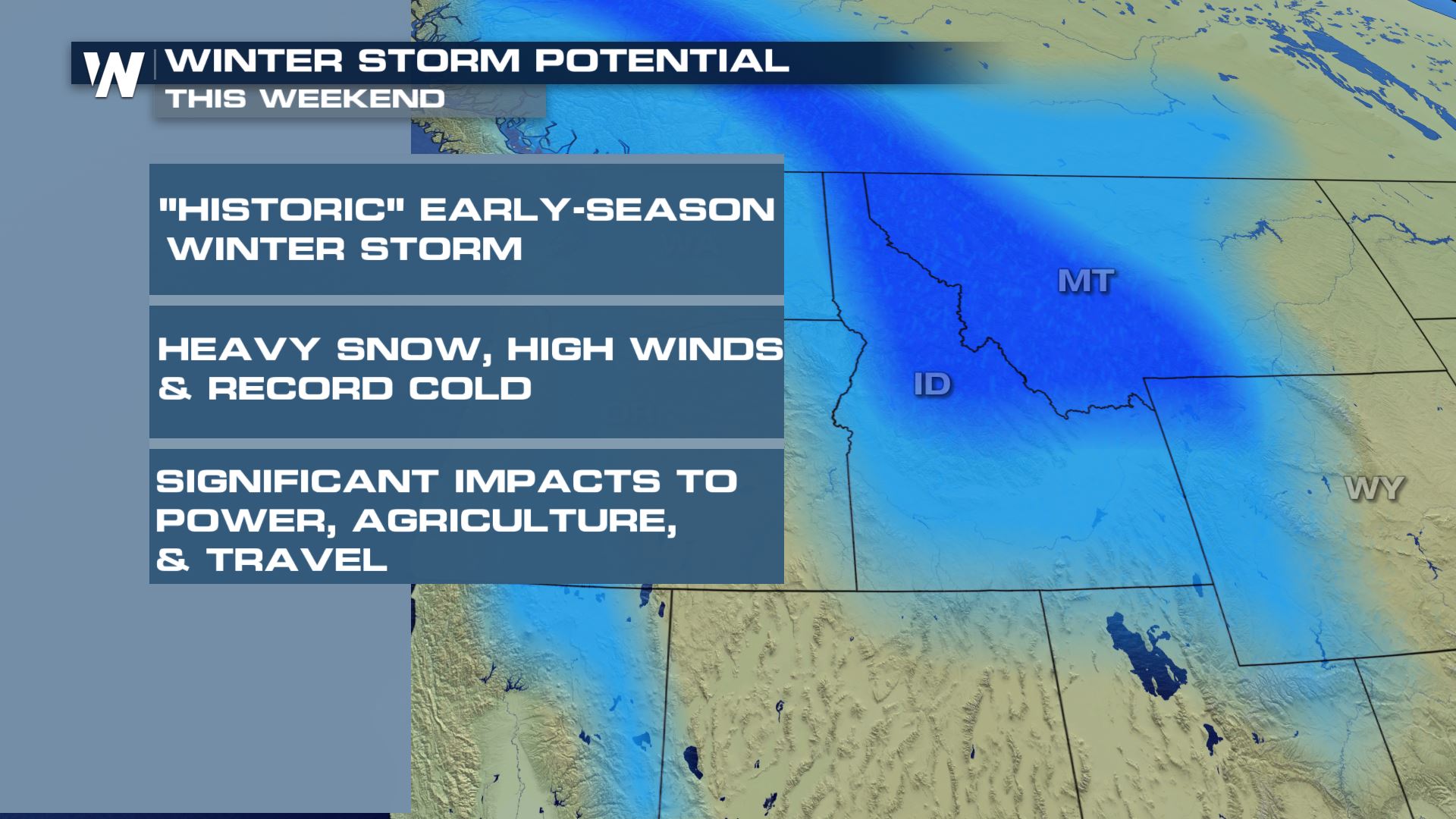 Snowfall totals within the Winter Storm Warning will reach up to 1-3 feet in the mountains. Some of the highest peaks may see locally higher reports. Temperatures will be so chilly, that snow levels will plummet into the valleys. Accumulations of 3-9" are possible even in lower elevations.
 Powerful winds could gust as high as 80 mph along the Rocky Mountain Front, prompting wind alerts in western Montana. These westerly surface winds will be strong enough to cause tree and power-line damage will ushering in cooler air. Travel will be difficult, if not impossible in certain situations.
 WeatherNation spoke with NWS Missoula, MT to talk about some of the local impacts to the area, stressing the impact to livestock and agriculture.
https://www.facebook.com/WeatherNation/videos/589831961551399/
Time of year is expected to enhance any potential impacts for several reasons. The amount of foliage still left on the trees only gives more surface area for the heavy, wet Fall snow to accumulate. This will likely cause more damaged to trees and power-lines, especially when paired with winds. Widespread power outages are anticipated with this storm.
For more on agricultural and livestock implications, click here.
WeatherNation spoke with NWS Missoula, MT to talk about some of the local impacts to the area, stressing the impact to livestock and agriculture.
https://www.facebook.com/WeatherNation/videos/589831961551399/
Time of year is expected to enhance any potential impacts for several reasons. The amount of foliage still left on the trees only gives more surface area for the heavy, wet Fall snow to accumulate. This will likely cause more damaged to trees and power-lines, especially when paired with winds. Widespread power outages are anticipated with this storm.
For more on agricultural and livestock implications, click here.
 Throughout Saturday, local officials and ski areas have been taking to social media to talk about what they are seeing.
https://twitter.com/TrooperAVilla/status/1177976247080501253
https://twitter.com/NWSGreatFalls/status/1177942973469708289
https://twitter.com/NWSSpokane/status/1177936010119798784
https://twitter.com/SchweitzerID/status/1177733911566151681
https://twitter.com/StevensPass/status/1177957753693753344
Stay with WeatherNation for the latest information.
Throughout Saturday, local officials and ski areas have been taking to social media to talk about what they are seeing.
https://twitter.com/TrooperAVilla/status/1177976247080501253
https://twitter.com/NWSGreatFalls/status/1177942973469708289
https://twitter.com/NWSSpokane/status/1177936010119798784
https://twitter.com/SchweitzerID/status/1177733911566151681
https://twitter.com/StevensPass/status/1177957753693753344
Stay with WeatherNation for the latest information.
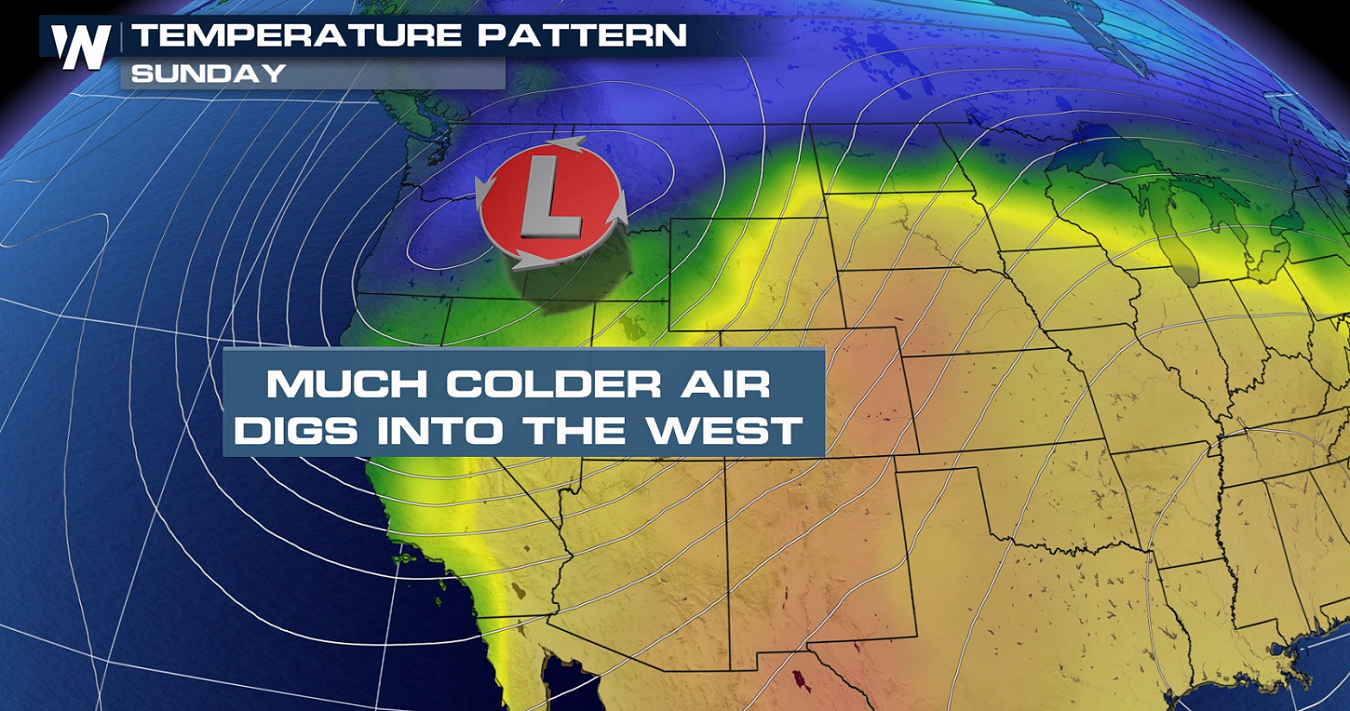
THE SET-UP
Through this weekend, a surface low pressure system will swing southward from Canada. A trough of low pressure in the mid and upper levels of the atmosphere will also deepen the push of cold air across the west. Temperatures will drop twenty or more degrees below average, to potential record low levels.
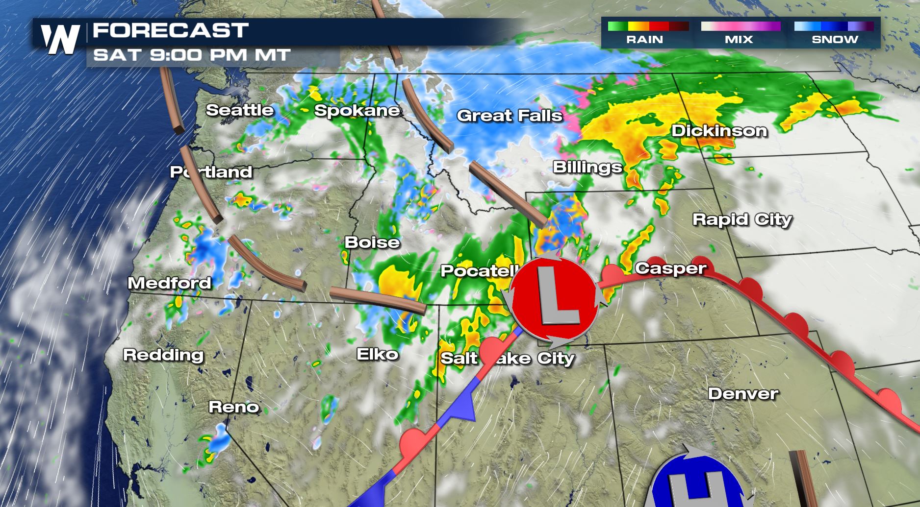
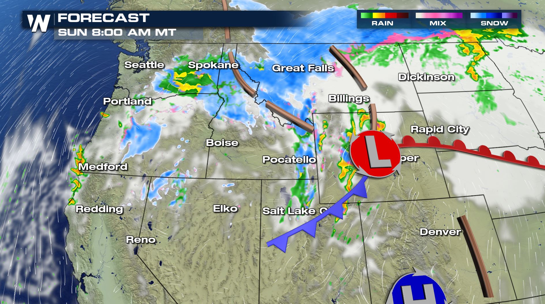
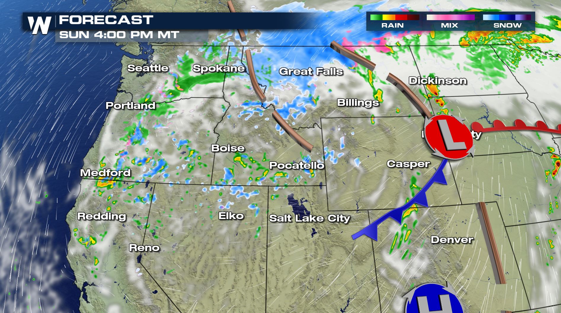
STORM TIMELINE
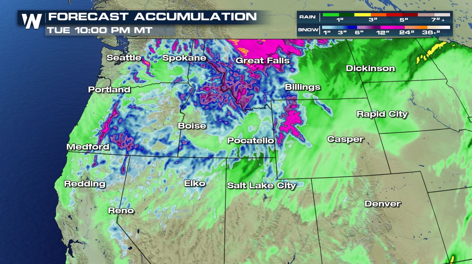
As low pressure at the earth's surface intensifies, winds will strengthen, rain and snow will develop, and temperatures will continue to fall. The system will slowly push south, allowing for widespread snow and rain across much of the northwestern U.S., especially in the higher terrain. Persistent, west snow will continue through the weekend and into Monday.
STORM IMPACTS
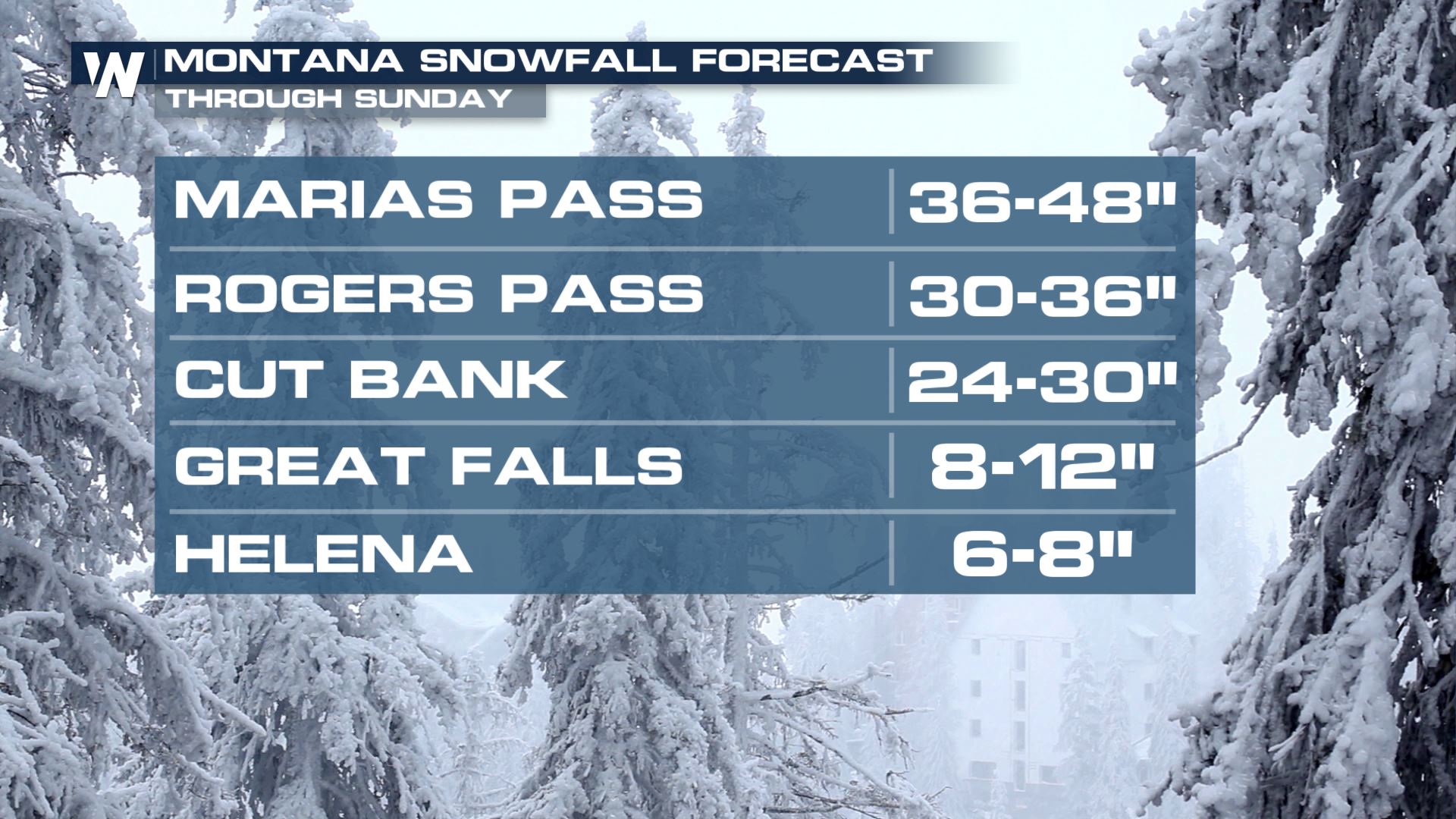
Snowfall totals within the Winter Storm Warning will reach up to 1-3 feet in the mountains. Some of the highest peaks may see locally higher reports. Temperatures will be so chilly, that snow levels will plummet into the valleys. Accumulations of 3-9" are possible even in lower elevations.
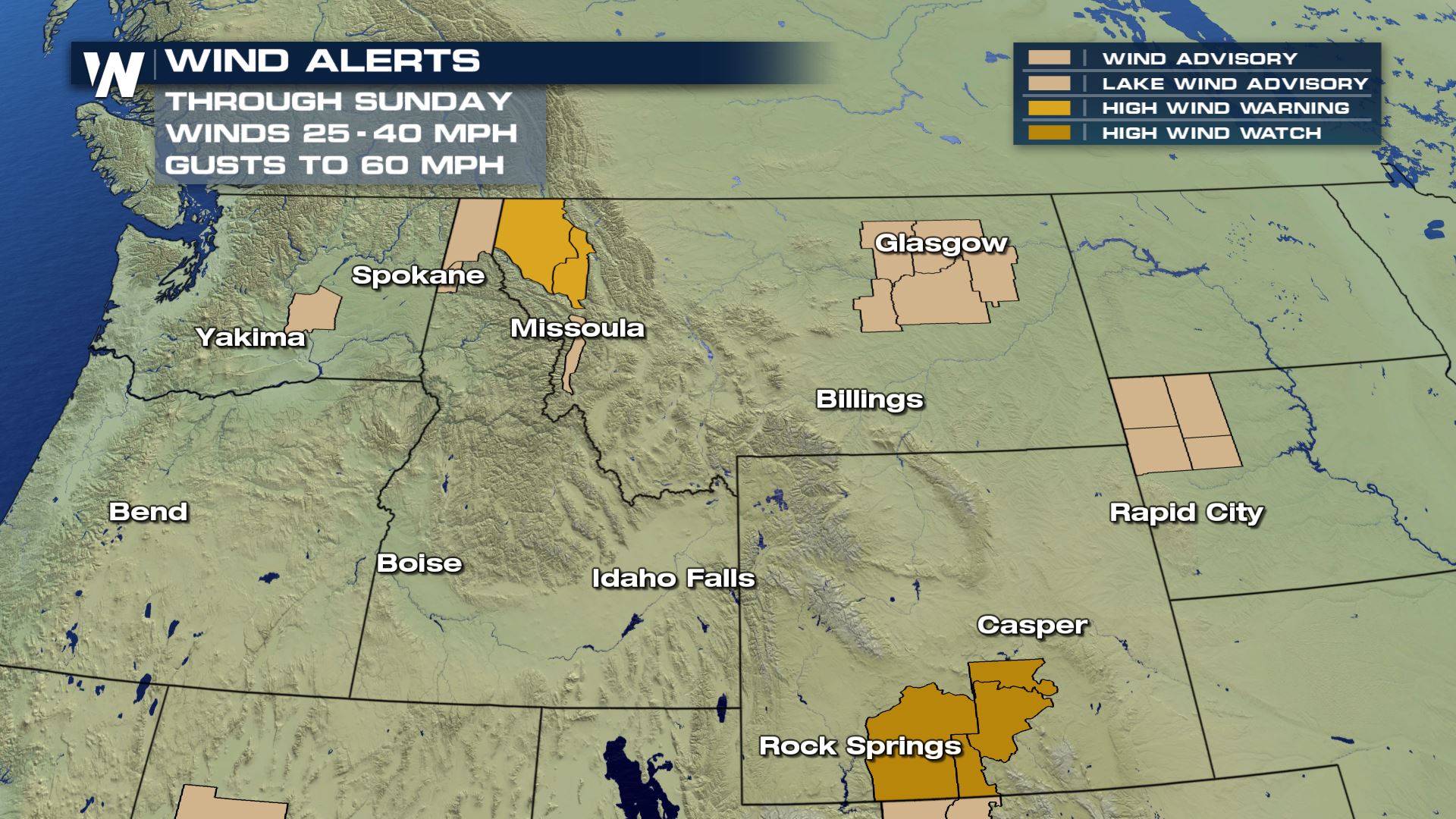
Powerful winds could gust as high as 80 mph along the Rocky Mountain Front, prompting wind alerts in western Montana. These westerly surface winds will be strong enough to cause tree and power-line damage will ushering in cooler air. Travel will be difficult, if not impossible in certain situations.
WeatherNation spoke with NWS Missoula, MT to talk about some of the local impacts to the area, stressing the impact to livestock and agriculture.
https://www.facebook.com/WeatherNation/videos/589831961551399/
Time of year is expected to enhance any potential impacts for several reasons. The amount of foliage still left on the trees only gives more surface area for the heavy, wet Fall snow to accumulate. This will likely cause more damaged to trees and power-lines, especially when paired with winds. Widespread power outages are anticipated with this storm.
For more on agricultural and livestock implications, click here.
Throughout Saturday, local officials and ski areas have been taking to social media to talk about what they are seeing.
https://twitter.com/TrooperAVilla/status/1177976247080501253
https://twitter.com/NWSGreatFalls/status/1177942973469708289
https://twitter.com/NWSSpokane/status/1177936010119798784
https://twitter.com/SchweitzerID/status/1177733911566151681
https://twitter.com/StevensPass/status/1177957753693753344
Stay with WeatherNation for the latest information.
All Weather News
More
Wildfire Outbreak in the Pacific Northwest
SPOKANE, WA - On Saturday, August 1st, the Ol
2 Aug 2026 7:20 PM

More Storms for the East Through Monday
A low-pressure system that moved through the
2 Aug 2026 7:20 PM


After Reaching Category 5, Genevieve Weakens in the Pacific
PacificGenevieve formed on last Friday south
2 Aug 2026 6:25 PM

Flooding, Severe Storms Target the Midwest Again
After an active week of storms across the nor
1 Aug 2026 1:40 AM

Flooding Risk Increases as Heavy Rain Targets the Tri-State Area
Tuesday, heavy rainfall moved across the Nort
30 Jul 2026 12:25 AM

Severe Weather: Energy From the Midwest Now in the Southeast
UPPER MIDWEST - Through Monday, dangerous tor
29 Jul 2026 10:30 PM