Huge Hail Hits Central U.S.
Special Stories
12 Mar 2020 3:37 PM
Huge hailstones were falling from the sky on Thursday, March 12 across parts of Illinois, Kentucky, Arkansas and some adjacent locations. Hail up to two inches in diameter (the width of hen eggs!) fell in parts of southern Illinois. Our field correspondent Meteorologist Brett Adair caught some of the large hailstones Thursday.
https://twitter.com/WeatherNation/status/1238198074398277632
A severe thunderstorm is classified as a storm that brings one or more of the following: 58 mph winds or stronger, 1" thick hail or larger, a tornado. When you hear of a severe thunderstorm warning, know the storm may very well bring those hazards.
https://www.facebook.com/WeatherNation/videos/217835802697020/
Social media user SturgeonScience caught this storm on camera Thursday as it rolled across parts of Missouri. Heavy rainfall of 1.1-1.3" fell within an hour under these thunderstorms! Please watch out for flooded roads overnight and avoid them!
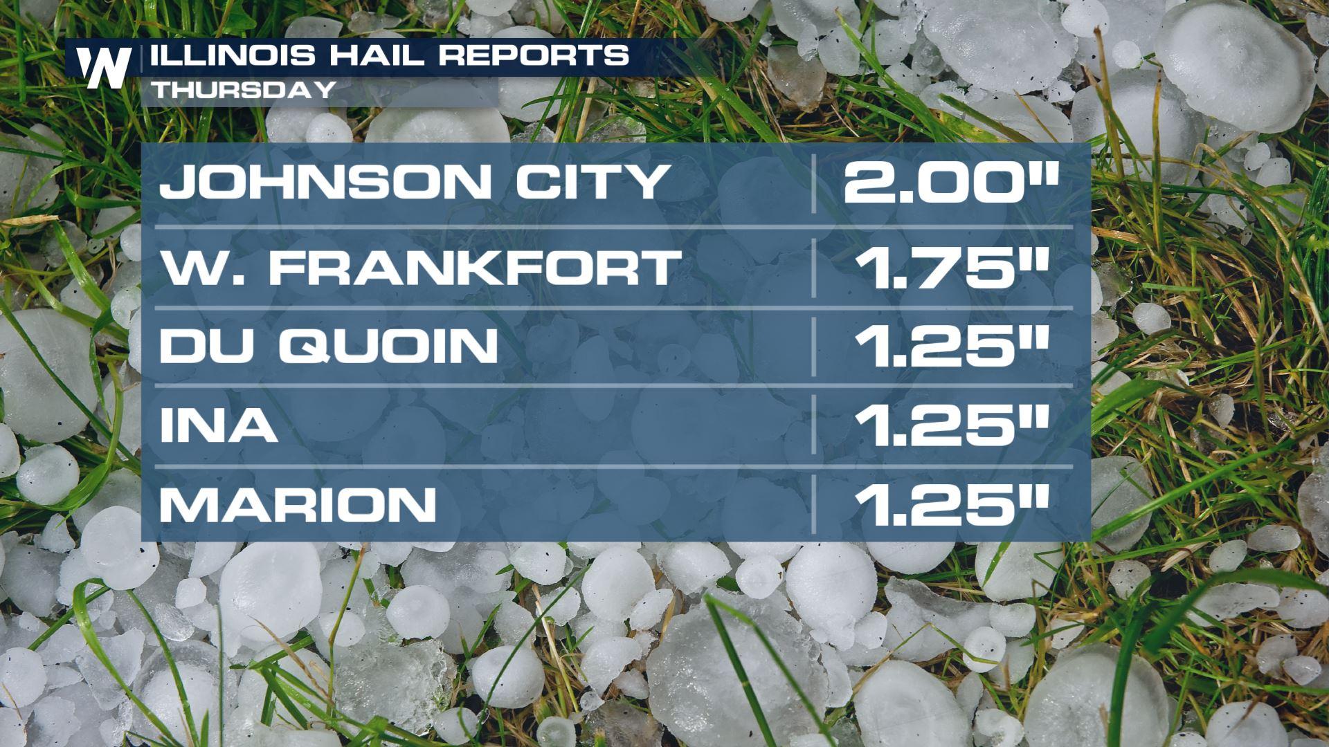
 The image above shows the diameters of the hailstones in various parts of Illinois. The 1.25" thickness equates to half dollar size hail, 1.75" equates to golf ball size, and 2" is equal to hen egg size! If you are in the path of these storms, move your vehicle to safety before they hit because damage may be done!
The thunderstorms will continue across parts of Kentucky, Tennessee, Missouri, Arkansas, Oklahoma, Texas and some adjacent locations through the night and early Friday morning. For more information on the severe weather forecast, see this article we previously published.
The image above shows the diameters of the hailstones in various parts of Illinois. The 1.25" thickness equates to half dollar size hail, 1.75" equates to golf ball size, and 2" is equal to hen egg size! If you are in the path of these storms, move your vehicle to safety before they hit because damage may be done!
The thunderstorms will continue across parts of Kentucky, Tennessee, Missouri, Arkansas, Oklahoma, Texas and some adjacent locations through the night and early Friday morning. For more information on the severe weather forecast, see this article we previously published.All Weather News
More
Gulf Coast Faces Flood Risk from Potential Tropical Cyclone One
TEXAS - Heavy rain has already led to issues
16 Jun 2026 11:45 PM

PTC ONE: First Forecast Cone of the Atlantic Basin
Potential Tropical Cyclone OneThe National Hu
16 Jun 2026 11:35 PM


Western Heat Wave Pushes into Work Week
Another ridge of high pressure is parked over
16 Jun 2026 8:00 PM

Welcome To Monsoon Season - Here's What to Expect
WELCOME TO THE NORTH AMERICAN MONSOON SEASON.
15 Jun 2026 8:00 PM

El Niño Forms, Very Strong El Niño Likely Late 2026
El Niño has arrived! It didn't take long for
15 Jun 2026 8:00 AM

Confirmed Tornadoes in Ohio and Pennsylvania on Sunday
A cold front on Sunday brought severe weather
15 Jun 2026 1:50 AM