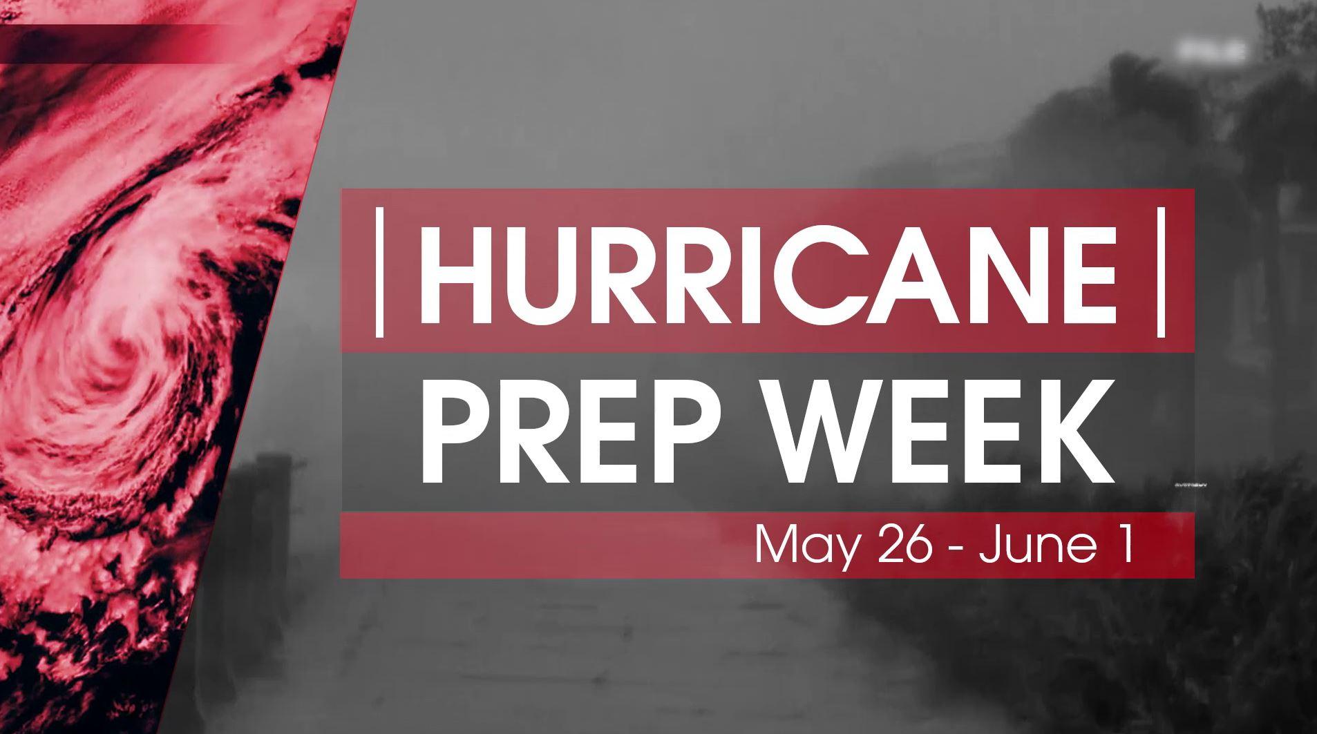
Hurricane Prep Week 2019
Special Stories
25 May 2019 10:05 AM
After an active hurricane season in 2018, it's hard to believe the next season is already here. Hurricane season began on May 15 for the Pacific Basin, and begins June 1 for the Atlantic basin.
It's time to get READY with WeatherNation during Hurricane Prep Week May 26-June 1. We'll help you get your plan together, understand the science behind tropical systems, and much more so you can be prepared this hurricane season.
Whether you live on the coastline or inland, it is important to know your risks when it comes to tropical systems. Coastal communities are most at risk of destructive winds, dangerous storm surge, and are more likely to have to evacuate. Communities even hundreds of miles away from coastlines are still at risk, with the threat of high winds, flooding rainfall, severe weather & tornadoes, and the longer lasting threat of flooding and power outages that could occur days or weeks after a storm hits.
GETTING READY FOR HURRICANE SEASON
https://youtu.be/3bY8xDQsqtk
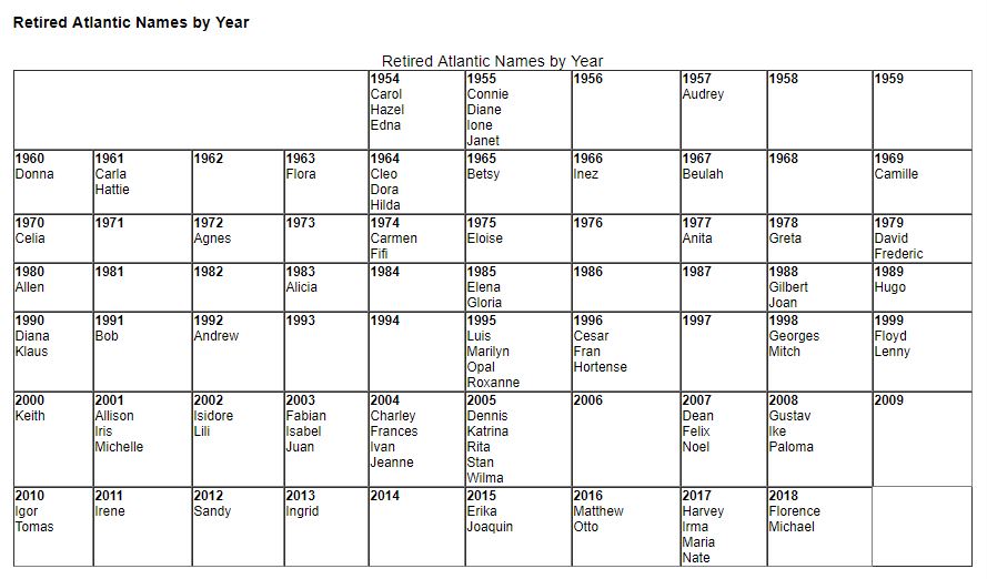 Source: https://www.nhc.noaa.gov/aboutnames_history.shtml
https://youtu.be/47clfTinREE
Being prepared before hurricane season is key to reacting quickly when a storm threatens your area. Understanding your risks where you live, and knowing how to react can mean the difference between saving your life and property when a storm approaches.
WeatherNation will continue to follow any and all systems that threaten the U.S. and Caribbean Islands throughout hurricane season to make sure you stay informed long before a storm strikes
Still have questions? Be sure to watch Hurricane Prep Week on WeatherNation, or get in touch with us on Facebook or Twitter.
Source: https://www.nhc.noaa.gov/aboutnames_history.shtml
https://youtu.be/47clfTinREE
Being prepared before hurricane season is key to reacting quickly when a storm threatens your area. Understanding your risks where you live, and knowing how to react can mean the difference between saving your life and property when a storm approaches.
WeatherNation will continue to follow any and all systems that threaten the U.S. and Caribbean Islands throughout hurricane season to make sure you stay informed long before a storm strikes
Still have questions? Be sure to watch Hurricane Prep Week on WeatherNation, or get in touch with us on Facebook or Twitter.
KNOW YOUR RISKS
WHAT'S THE FORECAST THIS SEASON? Hurricane season forecasts have already been released for the 2019 Atlantic and Pacific basins, including those from NOAA and Colorado State University. NOAA expects a "near normal" season for overall number of systems in the Atlantic basin with a total of 9-15 named storms, 4-8 of which are expected to become hurricanes. 2-4 of those hurricanes are expected to strengthen into a category 3, 4, or 5 (major) hurricane. In the central Pacific basin, NOAA expects a more active season as compared to normal with 5-8 named storms. [Related Article: NOAA Releases 2019 Atlantic hurricane forecast] https://www.youtube.com/watch?v=Xm-lJpuVNuI While seasonal outlooks give us some idea of what to expect, there is no way to know for certain just what the season will have in store for YOUR area. Seasonal outlooks cannot forecast exactly when, where, or if storm will strike. Remember, it only takes *one* to impact your area to become a "bad season". So, it's important to prepare before a storm threatens. LIVE INLAND? YOU AREN'T IMMUNE TO HURRICANES! Even if you live nowhere near a coastline, impacts from tropical systems can still occur. As seen in recent storms such as Hurricane Harvey (2017) and Hurricane Florence (2018) inland impacts can sometimes become even more extreme and far reaching than those right near the coast. Tropical Storm Allison (2001) and Hurricane Irene (2001) and Hurricane Lee (2001) all brought devastating inland impacts. Understand more about inland threats. https://www.youtube.com/watch?v=FBKLFsUUMyk UNDERSTANDING STORM SURGE Along the coast, storm surge is often the greatest threat to life and property from a hurricane. Storm surge has come along with some of the most powerful storms in history.Surge Vulnerability Facts (source: NHC)
- From 1990-2008, population density increased by 32% in Gulf coastal counties, 17% in Atlantic coastal counties, and 16% in Hawaii (U.S. Census Bureau 2010)
- Much of the United States' densely populated Atlantic and Gulf Coast coastlines lie less than 10 feet above mean sea level
- Over half of the Nation's economic productivity is located within coastal zones
- 72% of ports, 27% of major roads, and 9% of rail lines within the Gulf Coast region are at or below 4 ft elevation (CCSP, SAP 4-7)
- A storm surge of 23 ft has the ability to inundate 67% of interstates, 57% of arterials, almost half of rail miles, 29 airports, and virtually all ports in the Gulf Coast area (CCSP SAP 4-7)
PREPARE AT HOME
GET YOUR SUPPLY KIT READY Once your know your risks, you should put together an essential hurricane supply kit. There are two types of "kits" you should put together...one if you're sheltering at your home during a storm, and one that you can grab and go should you need to evacuate. [Get your supplies ready to shelter at home Click here for a full list of essentials from FEMA ] Here's what to pack in your "go kit" in case you will need to evacuate https://youtu.be/t3qaz2lRJXc COMMUNICATING THROUGH A TROPICAL SYSTEM Effective communication is critical to forecasters and emergency management to relay potentially life saving information to the public when tropical systems threaten. When a storm hits, sometimes the basic communication methods we are all familiar with, such as cell phones and internet, can fail. Learn more about communicating before and during the storm. https://youtu.be/MZBVzwhub6A PREPARING YOUR BOAT BEFORE A TROPICAL SYSTEM Many who live along the coast need to know what to do to secure their boat or vessel before a storm strikes. Boats can be greatly damaged, or cause damage to other property of if not properly secured or removed before a storm. https://youtu.be/Cmtuk8oJjW8 Additional Helpful Tips:- Learn much more and get storm ready by visiting Ready.Gov/Hurricanes
- Learn much more with FEMA to get hurricane smart
- Check your insurance coverage. If you are uninsured, apply BEFORE a storm threatens, as it may be too late if you wait
- Sign up for emergency alerts with your local county, city, or town to ensure you are receiving the most up to date information before and during a storm.
- Talk through your emergency plan with your family ahead of hurricane season
- Understand tropical weather terminology
ABOUT THE SCIENCE
We get it. There's ALOT of jargon, phrases, and information that can make understanding tropical cyclones difficult. Understanding the basics may help when a storm threatens. TROPICAL TERMINOLOGY It is important you understand certain tropical weather terminology to be better informed when a storm threatens. The difference between a tropical depression, tropical storm, and hurricane is simply wind speed. Each designation says nothing about particular impacts. Each system is unique, and listening to details of the forecast is key to being prepared and taking action if needed. WHAT IS THE SAFFIR-SIMPSON SCALE? The Saffir-Simpson Hurricane Wind Scale is a 1 to 5 rating based on a hurricane's sustained wind speed, with 5 being the highest. This scale estimates potential property damage. Hurricanes reaching Category 3 and higher are considered major hurricanes because of their potential for significant loss of life and damage. Category 1 and 2 storms are still dangerous, however, and require preventative measures. (Source: NHC) WHAT CAUSES A HURRICANE TO FORM? Most tropical cyclones start as a disorganized cluster of thunderstorms in the tropical latitudes around the Globe, known as a tropical wave. Under the right atmospheric conditions, tropical waves can transform into full blow tropical storms or, eventually, hurricanes. https://youtu.be/2beue2-MjIs WHY ARE STORMS GIVEN NAMES? As tropical systems develop and strengthen, they must reach a certain wind speed threshold to be given a name. According to NHC history, the use of easily remembered names greatly reduces confusion when two or more tropical storms occur at the same time. Names are determined years in advance of each season by the World Meteorological Organization for different ocean basins around the world. UNDERSTANDING THE FORECAST "CONE" Listening to forecast details can mean the difference between being prepared and caught off guard. Before a storm strikes, you'll often see a forecast "cone" to represent the expected forecast track of a system. Learn how to interpret the forecast track "cone" from the National Hurricane Center, and also how we relay that information visually on WeatherNation. https://youtu.be/HbA0aLkFDKw WHAT PART OF A HURRICANE IS THE MOST POWERFUL? When a hurricane threatens landfall, most often the most impacts will be felt on the "front right quadrant" in relation to the direction of movement. Impacts can and will be felt on all "sides" of a storm, but the threat of highest winds, storm surge, and indirect impacts, such as tornadoes, are often increased in the front right quadrant. https://youtu.be/X78lTSZQTNU RIDE ALONG WITH THE "HURRICANE HUNTERS" Do you ever wonder how data is gathered about tropical cyclones? To that, we turn to the "hurricane hunters"- teams of engineers, meteorologists, data scientists, pilots and others who fly directly into the heart of a storm to gather critical data about the cyclone. Get a look into the storm and data collected by NOAA's Hurricane Hunters and learn how the information they gather is critical to understand hurricanes and making a forecast. https://youtu.be/_ZVU5FVi4VE WHY CERTAIN STORM NAMES WILL NEVER BE USED AGAIN What do the names Katrina, Michael, Andrew, and Sandy all have in common? They are 4 of the 89 tropical names that will never be used again to identify a tropical cyclone. The World Meteorological Organization uses names to identify cyclones around the world, but some storms become so costly or destructive, they can never be used again. [Related link: Watch the top 5 most destructive hurricanes in U.S. history] Source: https://www.nhc.noaa.gov/aboutnames_history.shtml
https://youtu.be/47clfTinREE
Being prepared before hurricane season is key to reacting quickly when a storm threatens your area. Understanding your risks where you live, and knowing how to react can mean the difference between saving your life and property when a storm approaches.
WeatherNation will continue to follow any and all systems that threaten the U.S. and Caribbean Islands throughout hurricane season to make sure you stay informed long before a storm strikes
Still have questions? Be sure to watch Hurricane Prep Week on WeatherNation, or get in touch with us on Facebook or Twitter.All Weather News
More
Severe Weather: Energy From the Midwest Now in the Southeast
UPPER MIDWEST - Through Monday, dangerous tor
29 Jul 2026 2:25 PM


Flooding Risk Increases as Heavy Rain Targets the Tri-State Area
Tuesday, heavy rainfall moved across the nort
29 Jul 2026 2:00 PM

Tropics: Fausto Heads towards Hawaii; Genevieve a Major Hurricane
PacificTropical Depression Fausto continues t
29 Jul 2026 10:15 AM


Southeast Flood Risk Lingers Near Stalled Front
A stalled boundary over the Southeast will ke
25 Jul 2026 10:55 AM

Another Round of Storms Targets the Northeast
Tuesday brought severe weather again across p
23 Jul 2026 1:15 AM