Improving Marine Forecasts in Chesapeake Bay & Gulf of Maine

Special Stories
26 Feb 2019 4:14 AM
[Chesapeake Bay Bridge at Twilight. Photo By: @Motoxdms from Instagram via Maryland Office of Tourism]
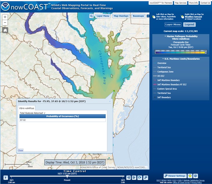
[NOAA] NOAA’s nowCOAST, a GIS-based online web mapping service that provides frequently updated weather and ocean observations, analyses, imagery, and ocean model forecast guidance, along with weather watches and warnings and forecasts, now provides maps of oceanographic forecast guidance from the National Ocean Service (NOS) 3-D operational forecast modeling system for the Gulf of Maine (GoMOFS) and NOS forecast guidance of the marine pathogen, Vibrio Vulnificus (Vv), for the Chesapeake Bay via two new map services and map viewer.
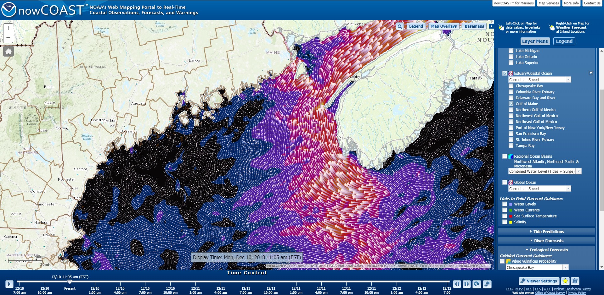 GoMOFS provides high resolution nowcasts (analyses) and forecast guidance of 3-D water currents, water temperatures, and salinity at 3-hourly increments out to 48 hours. NOS’ latest forecast guidance on the probability of occurrence of Vv, a marine pathogen which can cause illness and hospitalization, is issued once per day for Chesapeake Bay and includes predictions for the present day (Day 1) and the next day (Day 2).
Additional nowCOAST updates include:
GoMOFS provides high resolution nowcasts (analyses) and forecast guidance of 3-D water currents, water temperatures, and salinity at 3-hourly increments out to 48 hours. NOS’ latest forecast guidance on the probability of occurrence of Vv, a marine pathogen which can cause illness and hospitalization, is issued once per day for Chesapeake Bay and includes predictions for the present day (Day 1) and the next day (Day 2).
Additional nowCOAST updates include:
 nowCOAST is an ArcGIS-based web mapping application developed by the Office of Coast Survey’s Coast Survey Development Laboratory and is hosted on NOAA’s 24×7 Integrated Dissemination Program IT infrastructure operated by the National Weather Service’s National Centers for Environmental Prediction.
Edited for WeatherNation by Meteorologist Mace Michaels
nowCOAST is an ArcGIS-based web mapping application developed by the Office of Coast Survey’s Coast Survey Development Laboratory and is hosted on NOAA’s 24×7 Integrated Dissemination Program IT infrastructure operated by the National Weather Service’s National Centers for Environmental Prediction.
Edited for WeatherNation by Meteorologist Mace Michaels
GoMOFS provides high resolution nowcasts (analyses) and forecast guidance of 3-D water currents, water temperatures, and salinity at 3-hourly increments out to 48 hours. NOS’ latest forecast guidance on the probability of occurrence of Vv, a marine pathogen which can cause illness and hospitalization, is issued once per day for Chesapeake Bay and includes predictions for the present day (Day 1) and the next day (Day 2).
Additional nowCOAST updates include:
- Incorporation of water level forecast guidance from NOS Extratropical Surge and Tide Operational Forecast System (ESTOFS) for Micronesia into the existing ESTOFS map service.
- Ability to display National Hurricane Center Potential Storm Surge Flooding Maps for multiple tropical cyclones at the same time.
- Addition of georeferenced hyperlinks to Canada Marine Weather Forecast Zones.
nowCOAST is an ArcGIS-based web mapping application developed by the Office of Coast Survey’s Coast Survey Development Laboratory and is hosted on NOAA’s 24×7 Integrated Dissemination Program IT infrastructure operated by the National Weather Service’s National Centers for Environmental Prediction.
Edited for WeatherNation by Meteorologist Mace MichaelsAll Weather News
More
Wildfire Outbreak in the Pacific Northwest
SPOKANE, WA - On Saturday, August 1st, the Ol
2 Aug 2026 7:20 PM

More Storms for the East Through Monday
A low-pressure system that moved through the
2 Aug 2026 7:20 PM


After Reaching Category 5, Genevieve Weakens in the Pacific
PacificGenevieve formed on last Friday south
2 Aug 2026 6:25 PM

Flooding, Severe Storms Target the Midwest Again
After an active week of storms across the nor
1 Aug 2026 1:40 AM

Flooding Risk Increases as Heavy Rain Targets the Tri-State Area
Tuesday, heavy rainfall moved across the Nort
30 Jul 2026 12:25 AM

Severe Weather: Energy From the Midwest Now in the Southeast
UPPER MIDWEST - Through Monday, dangerous tor
29 Jul 2026 10:30 PM