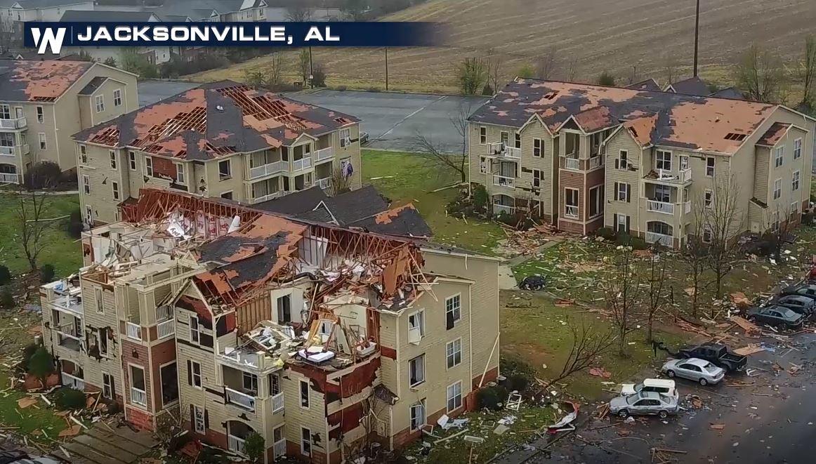
Jacksonville an EF-3 Tornado, NWS Says
Special Stories
20 Mar 2018 2:39 PM
The National Weather Service Office in Birmingham, Alabama confirmed Tuesday that the damage found in Jacksonville was that of an EF-3 tornado.
The National Weather Service said that their field team found that the tornado had a peak intensity of winds near 140 miles per hour.
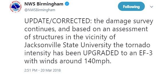 Originally, the survey team said they found damage from winds near 130 miles per hour, but after checking buildings near Jacksonville State University, they upgraded the tornado from an EF-2 to an EF-3.
https://twitter.com/NWSBirmingham/status/976174895234277378
That same storm that produced a tornado in Jacksonville went on to produce more tornadoes, according to the NWS.
On Monday night, several tornado warnings were issued for the Jacksonville area, including Jacksonville State University.
https://twitter.com/WeatherNation/status/975911307621761024
https://twitter.com/NWSBirmingham/status/975912623039533057
After the warnings were cleared, WeatherNation was on scene to check out some of the damage.
https://www.facebook.com/WeatherNation/videos/10156354125769874/
It was not until Tuesday morning could we see the full extent of damage in the town.
https://www.facebook.com/WeatherNation/videos/10156355623499874/
https://www.facebook.com/WeatherNation/videos/10156355857394874/
The National Weather Service surveyed the damage Tuesday afternoon and concluded that it was indeed a tornado that caused the significant damage to the city.
Several injuries were reported but thankfully no deaths have been reported thus far.
https://www.facebook.com/WeatherNation/videos/10156354938254874/
Originally, the survey team said they found damage from winds near 130 miles per hour, but after checking buildings near Jacksonville State University, they upgraded the tornado from an EF-2 to an EF-3.
https://twitter.com/NWSBirmingham/status/976174895234277378
That same storm that produced a tornado in Jacksonville went on to produce more tornadoes, according to the NWS.
On Monday night, several tornado warnings were issued for the Jacksonville area, including Jacksonville State University.
https://twitter.com/WeatherNation/status/975911307621761024
https://twitter.com/NWSBirmingham/status/975912623039533057
After the warnings were cleared, WeatherNation was on scene to check out some of the damage.
https://www.facebook.com/WeatherNation/videos/10156354125769874/
It was not until Tuesday morning could we see the full extent of damage in the town.
https://www.facebook.com/WeatherNation/videos/10156355623499874/
https://www.facebook.com/WeatherNation/videos/10156355857394874/
The National Weather Service surveyed the damage Tuesday afternoon and concluded that it was indeed a tornado that caused the significant damage to the city.
Several injuries were reported but thankfully no deaths have been reported thus far.
https://www.facebook.com/WeatherNation/videos/10156354938254874/All Weather News
More
Tropics: Fausto Heads towards Hawaii; Genevieve Cat 4 Hurricane
PacificTropical Storm Fausto continues to tra
28 Jul 2026 2:30 PM

Severe Storms Move From Midwest to Northeast
UPPER MIDWEST - Through Monday, dangerous tor
28 Jul 2026 2:25 PM


Southeast Flood Risk Lingers Near Stalled Front
A stalled boundary over the Southeast will ke
25 Jul 2026 10:55 AM

Another Round of Storms Targets the Northeast
Tuesday brought severe weather again across p
23 Jul 2026 1:15 AM

Another Round of Severe Weather for the Upper Midwest and Great Lakes
The upper-level low train continues to keep t
21 Jul 2026 1:45 AM