January 2019 Outlook from NOAA's Climate Prediction Center
Special Stories
21 Dec 2018 3:09 PM
On Thursday, the Climate Prediction Center issued their 30 day forecast for January. Warmer than normal temperatures are expected across most of the West, with below average readings in the Southeast. The South is expected to see wetter than normal weather, with below average precipitation in the Northwest and Ohio Valley.
https://twitter.com/NWSCPC/status/1075749752531230721
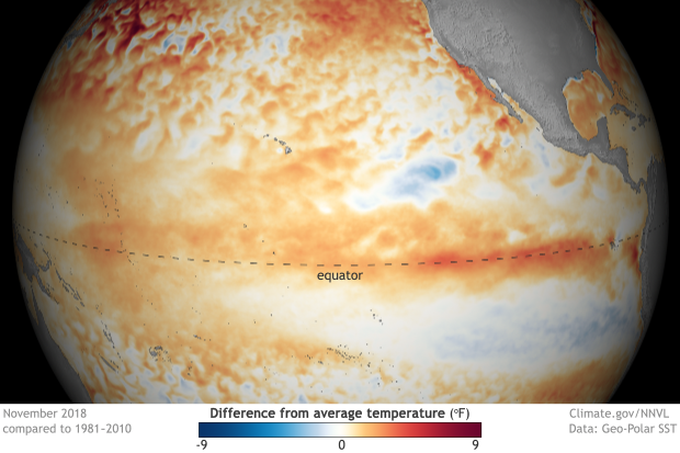
The main forecast influences were global pattern trends and long range model forecasts. An extensively discussed El Nino is underway in the Pacific Ocean, but the atmosphere has yet to respond. Observed sea surface temperatures in the Pacific are warmer than normal as expected, with computer models expecting this to continue. Right now, the overall global pattern resembles neutral conditions. Based on the latest observations and model forecasts, the CPC still indicates a greater than 80 percent chance for El Nino from January to March and 70 percent that it persists through May.
 [November 2018 sea surface temperature departure from the 1981-2010 average. Graphic by NOAA Climate; data from NOAA’s Environmental Visualization Lab.]
For WeatherNation: Meteorologist Mace Michaels
 [November 2018 sea surface temperature departure from the 1981-2010 average. Graphic by NOAA Climate; data from NOAA’s Environmental Visualization Lab.]
For WeatherNation: Meteorologist Mace Michaels
All Weather News
More