Large Cloud of Saharan Dust headed toward the U.S. and Caribbean - How It Impacts Hurricanes and Sunsets
Special Stories
18 Jun 2020 11:00 AM
A massive plume of dust is heading west from Africa and is expected to drift through the Caribbean and Gulf of Mexico through Father's Day weekend, with impacts to the United States possible through the following weekend.
[embed]https://twitter.com/CIRA_CSU/status/1272994500604915713[/embed]
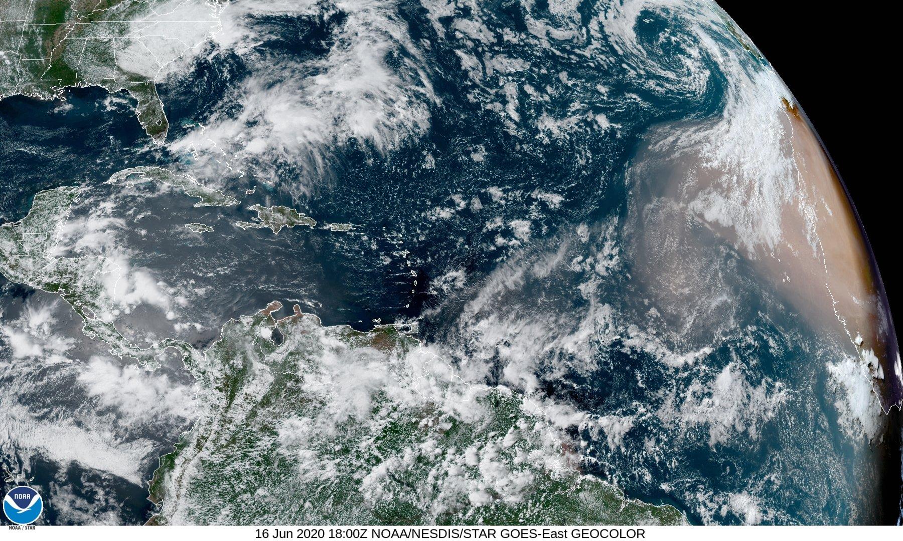
GOES-16 has been capturing the dust over several days drifting over the Eastern Atlantic Ocean (see more of these amazing views at the link in the tweet above).
Plumes like these are a regular occurrence during the summer months and can play a role in everything from dampening development of tropical systems, like hurricanes, to boosting bright sunset colors in North America. There have been several smaller pulses of dust this season, but this plume is the largest yet that has been forecast to reach the Caribbean, Gulf of Mexico and eventually, the United States.
These waves of sand and particulate matter are known as the Saharan Air Layer (SAL), which typically form from late spring through early fall, peaking in activity in June and July, and declining in August. They regularly move off the coast of Africa every 3-5 days in a layer between 5,000 and 18,000 feet above the sea surface, and can cover an area as large as the United States.
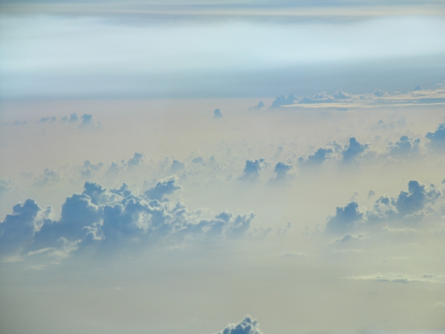 Dust layer associated with the Saharan Air Layer. Photo taken from the NOAA G-IV northeast of Barbados during SALEX mission 20060916. Credit: Jason Dunion NOAA/HRD.
As you would expect, the air in these plumes of dust is quite dry and warm, usually containing about 50% of the moisture content of the surrounding air over the Tropical Atlantic Ocean. This dry and warm air helps to inhibit thunderstorm development through several processes. The warm air in the dust layer creates a strong temperature inversion, which suppresses the updrafts needed to maintain shower and thunderstorm activity. The dry air also aides in accelerating downdrafts, which further aides in creating a more stable atmosphere. Finally, the jet that carries the dust quickly to west can be strong enough at times to create strong shear (the change of wind with height) to tear apart tropical cyclone development.
Fewer thunderstorms typically mean lower chances for tropical systems to develop, but storms have survived large plumes of dust in the past so, each situation has to be assessed independently.
These plumes can also make sunsets much more colorful when the dust is thick in the air, since the increase in particulate matter leads to additional scattering of visible light. South Florida may see an increase in colors as early as Father's Day weekend, while many states along the Gulf Coast could see similar effects through much of the following week (see the bottom of the page for a link of the extended dust forecast).
Among other benefits, these plumes can have negative impacts as well, including reducing air quality. They can also lead to toxic algae outbreaks in the Gulf of Mexico.
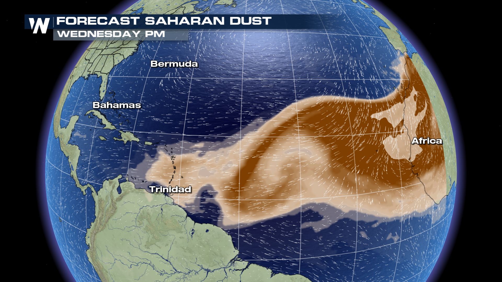
The most recent plume is expected to move across the Windward Islands and increase in thickness through the end of the week. The forecast snapshots below show where the plume is expected to move through Friday evening.
Dust layer associated with the Saharan Air Layer. Photo taken from the NOAA G-IV northeast of Barbados during SALEX mission 20060916. Credit: Jason Dunion NOAA/HRD.
As you would expect, the air in these plumes of dust is quite dry and warm, usually containing about 50% of the moisture content of the surrounding air over the Tropical Atlantic Ocean. This dry and warm air helps to inhibit thunderstorm development through several processes. The warm air in the dust layer creates a strong temperature inversion, which suppresses the updrafts needed to maintain shower and thunderstorm activity. The dry air also aides in accelerating downdrafts, which further aides in creating a more stable atmosphere. Finally, the jet that carries the dust quickly to west can be strong enough at times to create strong shear (the change of wind with height) to tear apart tropical cyclone development.
Fewer thunderstorms typically mean lower chances for tropical systems to develop, but storms have survived large plumes of dust in the past so, each situation has to be assessed independently.
These plumes can also make sunsets much more colorful when the dust is thick in the air, since the increase in particulate matter leads to additional scattering of visible light. South Florida may see an increase in colors as early as Father's Day weekend, while many states along the Gulf Coast could see similar effects through much of the following week (see the bottom of the page for a link of the extended dust forecast).
Among other benefits, these plumes can have negative impacts as well, including reducing air quality. They can also lead to toxic algae outbreaks in the Gulf of Mexico.
The most recent plume is expected to move across the Windward Islands and increase in thickness through the end of the week. The forecast snapshots below show where the plume is expected to move through Friday evening.
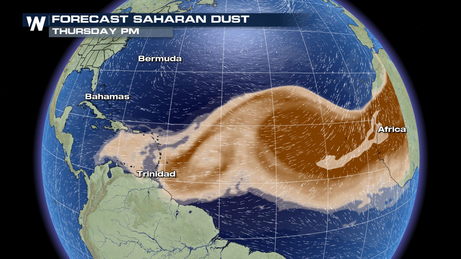
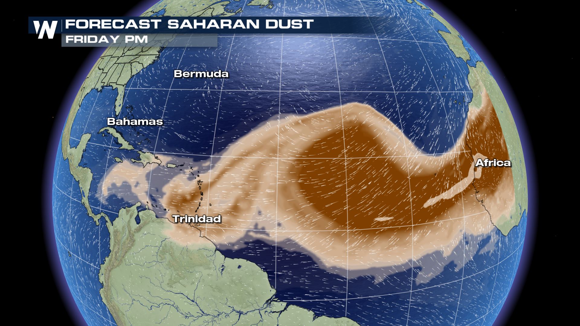 Dust is expected to thicken in the Gulf of Mexico after Father's Day Sunday, but could linger or even increase in thickness across the Gulf States and the Southeastern U.S. into the following weekend.
[embed]https://twitter.com/NWSHouston/status/1272870230876971009[/embed]
Keep up with the latest dust forecast at this website, courtesy of NASA. If you live in areas that could be impacted, be sure to check for the air quality forecast and limit outdoor activity if you are suffering from a respiratory condition.
Dust is expected to thicken in the Gulf of Mexico after Father's Day Sunday, but could linger or even increase in thickness across the Gulf States and the Southeastern U.S. into the following weekend.
[embed]https://twitter.com/NWSHouston/status/1272870230876971009[/embed]
Keep up with the latest dust forecast at this website, courtesy of NASA. If you live in areas that could be impacted, be sure to check for the air quality forecast and limit outdoor activity if you are suffering from a respiratory condition.
Dust layer associated with the Saharan Air Layer. Photo taken from the NOAA G-IV northeast of Barbados during SALEX mission 20060916. Credit: Jason Dunion NOAA/HRD.
As you would expect, the air in these plumes of dust is quite dry and warm, usually containing about 50% of the moisture content of the surrounding air over the Tropical Atlantic Ocean. This dry and warm air helps to inhibit thunderstorm development through several processes. The warm air in the dust layer creates a strong temperature inversion, which suppresses the updrafts needed to maintain shower and thunderstorm activity. The dry air also aides in accelerating downdrafts, which further aides in creating a more stable atmosphere. Finally, the jet that carries the dust quickly to west can be strong enough at times to create strong shear (the change of wind with height) to tear apart tropical cyclone development.
Fewer thunderstorms typically mean lower chances for tropical systems to develop, but storms have survived large plumes of dust in the past so, each situation has to be assessed independently.
These plumes can also make sunsets much more colorful when the dust is thick in the air, since the increase in particulate matter leads to additional scattering of visible light. South Florida may see an increase in colors as early as Father's Day weekend, while many states along the Gulf Coast could see similar effects through much of the following week (see the bottom of the page for a link of the extended dust forecast).
Among other benefits, these plumes can have negative impacts as well, including reducing air quality. They can also lead to toxic algae outbreaks in the Gulf of Mexico.
The most recent plume is expected to move across the Windward Islands and increase in thickness through the end of the week. The forecast snapshots below show where the plume is expected to move through Friday evening.
Dust is expected to thicken in the Gulf of Mexico after Father's Day Sunday, but could linger or even increase in thickness across the Gulf States and the Southeastern U.S. into the following weekend.
[embed]https://twitter.com/NWSHouston/status/1272870230876971009[/embed]
Keep up with the latest dust forecast at this website, courtesy of NASA. If you live in areas that could be impacted, be sure to check for the air quality forecast and limit outdoor activity if you are suffering from a respiratory condition.All Weather News
More
Wildfire Outbreak in the Pacific Northwest
SPOKANE, WA - On Saturday, August 1st, the Ol
2 Aug 2026 7:20 PM

More Storms for the East Through Monday
A low-pressure system that moved through the
2 Aug 2026 7:20 PM


After Reaching Category 5, Genevieve Weakens in the Pacific
PacificGenevieve formed on last Friday south
2 Aug 2026 6:25 PM

Flooding, Severe Storms Target the Midwest Again
After an active week of storms across the nor
1 Aug 2026 1:40 AM

Flooding Risk Increases as Heavy Rain Targets the Tri-State Area
Tuesday, heavy rainfall moved across the Nort
30 Jul 2026 12:25 AM

Severe Weather: Energy From the Midwest Now in the Southeast
UPPER MIDWEST - Through Monday, dangerous tor
29 Jul 2026 10:30 PM