Late Winter Storms Boost Western Snowpack
Special Stories
15 Apr 2020 8:06 AM
California is still playing catch up, but several recent winter storms have added a cherry on top of the solid snowpack in the Western United States. Snowpack plays a number of important roles after the winter months, including provided water for drinking, agriculture, fire suppression, and recreation.
 A multi-day rain and snow event pummeled California's Sierra Nevada, with several feet of accumulation piling up over the first weekend in April. The wet storm then remained nearly stationary over the southern half of the state, where it continued to deliver heavy rain and high elevation snow through the following Friday.
[embed]https://twitter.com/NWSHanford/status/1249046338794188801[/embed]
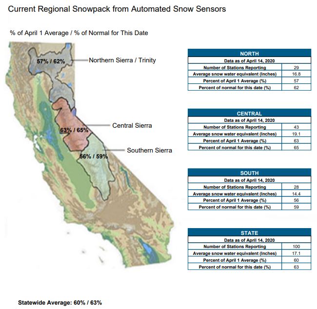
The biggest changes to the snowpack were recorded over the Southern Sierra where liquid snow equivalent snowpack increased by 32%! The heavy accumulation even created some massive snow rollers. Percent of normal snowpack in the Southern Sierra jumped from 44% of normal on April 4th to 60% of normal on April 11th.
A multi-day rain and snow event pummeled California's Sierra Nevada, with several feet of accumulation piling up over the first weekend in April. The wet storm then remained nearly stationary over the southern half of the state, where it continued to deliver heavy rain and high elevation snow through the following Friday.
[embed]https://twitter.com/NWSHanford/status/1249046338794188801[/embed]
The biggest changes to the snowpack were recorded over the Southern Sierra where liquid snow equivalent snowpack increased by 32%! The heavy accumulation even created some massive snow rollers. Percent of normal snowpack in the Southern Sierra jumped from 44% of normal on April 4th to 60% of normal on April 11th.
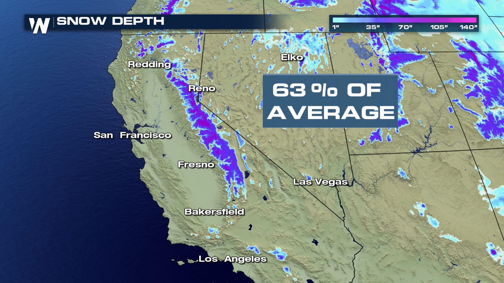
 The recent accumulation has melted slightly in the days following the storm, but overall in the Sierra snowpack increased about 10%, compared to normal snowpack, from just the one storm system to 63%. For comparison, last year the Sierra snowpack measured in at 160% of normal, but in 2014, during California's multi-year drought, snowpack on April 14th was 25% of normal.
[embed]https://twitter.com/NWSBayArea/status/1250154456643031040[/embed]
The recent storm has left the Central Valley and surrounding areas greener and whiter, depending on elevation.
The recent accumulation has melted slightly in the days following the storm, but overall in the Sierra snowpack increased about 10%, compared to normal snowpack, from just the one storm system to 63%. For comparison, last year the Sierra snowpack measured in at 160% of normal, but in 2014, during California's multi-year drought, snowpack on April 14th was 25% of normal.
[embed]https://twitter.com/NWSBayArea/status/1250154456643031040[/embed]
The recent storm has left the Central Valley and surrounding areas greener and whiter, depending on elevation.
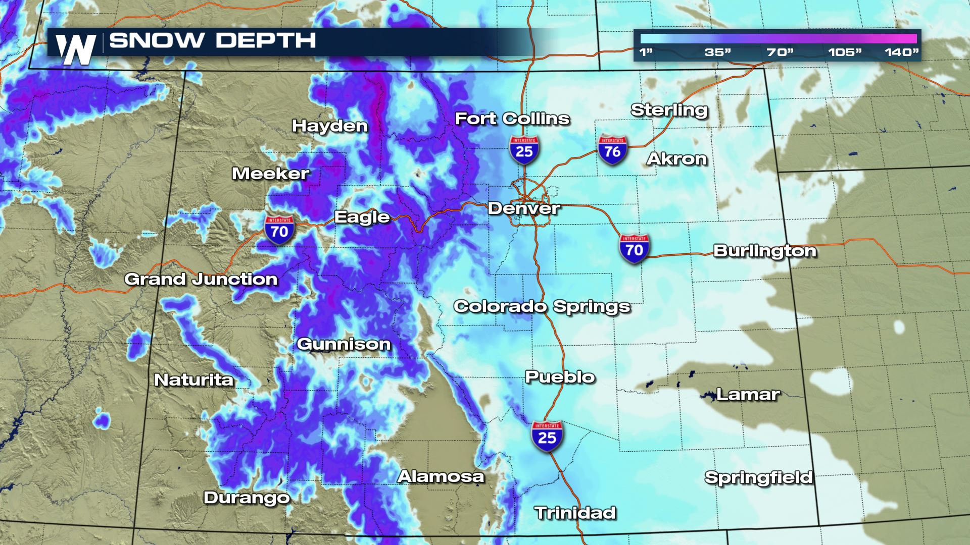 Colorado and the Rockies have also recently added to the already impressive snowpack out west, and even more is expected to pileup through Friday. Colorado's snow water equivalent (SWE) is 90% of normal or above in 7 out of the 8 basins that are monitored. The lone basin below 90%, the Upper Rio Grande Valley, has 83% of its typical SWE.
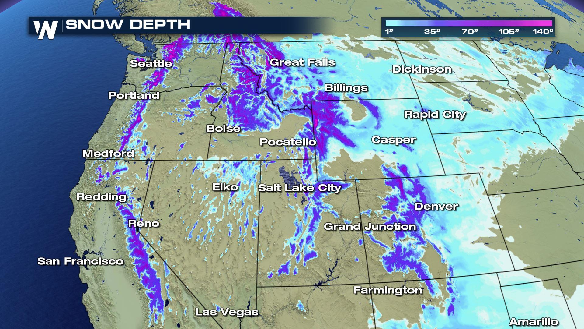
 Overall, snowpack across the West, especially in the Rockies, is near or above average for mid-April. The Sierra and Southern Cascades of Oregon are the exceptions, bewteen 60-75 % of normal to date. The mountains of Arizona and New Mexico however, remain well below average.
A multi-day rain and snow event pummeled California's Sierra Nevada, with several feet of accumulation piling up over the first weekend in April. The wet storm then remained nearly stationary over the southern half of the state, where it continued to deliver heavy rain and high elevation snow through the following Friday.
[embed]https://twitter.com/NWSHanford/status/1249046338794188801[/embed]
The biggest changes to the snowpack were recorded over the Southern Sierra where liquid snow equivalent snowpack increased by 32%! The heavy accumulation even created some massive snow rollers. Percent of normal snowpack in the Southern Sierra jumped from 44% of normal on April 4th to 60% of normal on April 11th.
The recent accumulation has melted slightly in the days following the storm, but overall in the Sierra snowpack increased about 10%, compared to normal snowpack, from just the one storm system to 63%. For comparison, last year the Sierra snowpack measured in at 160% of normal, but in 2014, during California's multi-year drought, snowpack on April 14th was 25% of normal.
[embed]https://twitter.com/NWSBayArea/status/1250154456643031040[/embed]
The recent storm has left the Central Valley and surrounding areas greener and whiter, depending on elevation.
Colorado and the Rockies have also recently added to the already impressive snowpack out west, and even more is expected to pileup through Friday. Colorado's snow water equivalent (SWE) is 90% of normal or above in 7 out of the 8 basins that are monitored. The lone basin below 90%, the Upper Rio Grande Valley, has 83% of its typical SWE.
Overall, snowpack across the West, especially in the Rockies, is near or above average for mid-April. The Sierra and Southern Cascades of Oregon are the exceptions, bewteen 60-75 % of normal to date. The mountains of Arizona and New Mexico however, remain well below average.All Weather News
More
Hurricane Center Monitoring Florida for Tropical Development
Residents and visitors to the Southeast will
30 Jun 2025 10:00 PM

Barry Makes Landfall, Watching Flossie Next
While the Eastern Pacific has made most of th
30 Jun 2025 9:40 PM

Severe Storms For the East Coast Through Tuesday
Frontal systems have been crossing the northe
30 Jun 2025 9:00 PM

Severe Weather Threat Continues in the Midwest
It has been an active, severe season across t
30 Jun 2025 9:00 PM


Where Rain Could Dampen Holiday Travel Plans
AAA is expecting over 70 million travelers to
30 Jun 2025 3:00 PM

Thunderstorms Possible in the Southeast Overnight
SOUTHEAST - Strong thunderstorms have develop
28 Jun 2025 2:40 AM