Major Flooding Forecast to Continue Along The Mississippi
Top Stories
4 May 2019 2:41 PM
Up and down the Great Mississippi River the flood levels are expected to cause major implications.
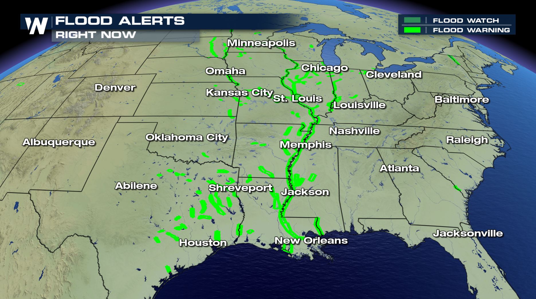
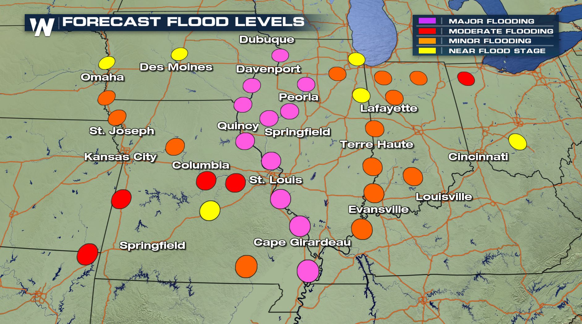 The purple dots above correspond to forecast river levels through the early part of the week of May 6th, 2019. This is where water will rise to levels high enough to cause widespread impacts. A majority of these purple dots hover near the Mississippi River, running north to south across the midsection of the country.
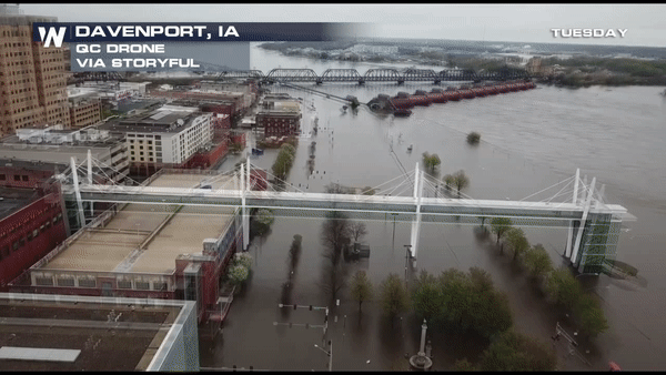
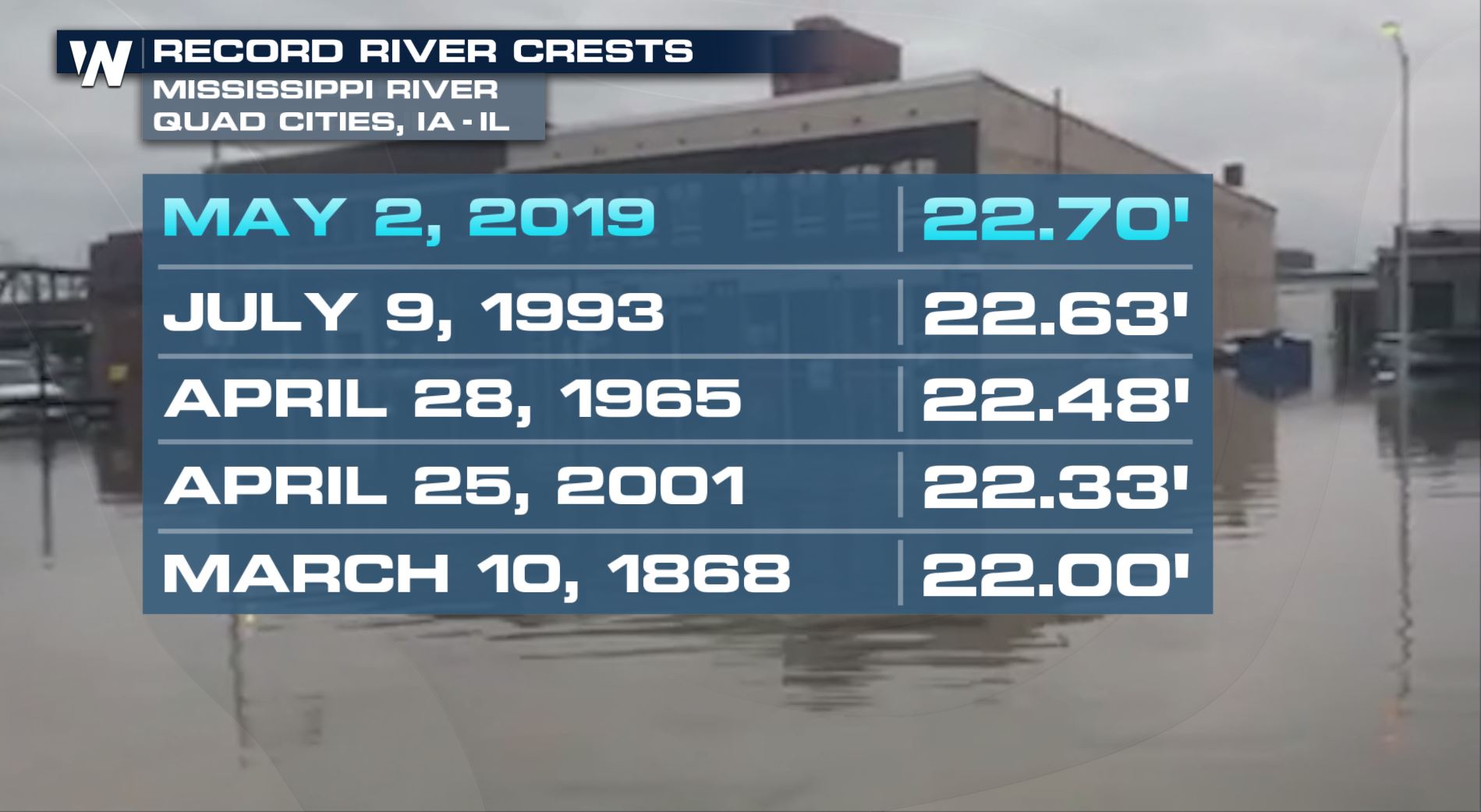 Last week the Quad Cities experienced never-before-recorded water levels when the river gauge hit 22.7 feet. Major flood stage here begins at 18.0 feet and it rose nearly 5 feet above that! Fortunately the river forecast in Davenport is promising, showing a slow but steady drop in the water level.
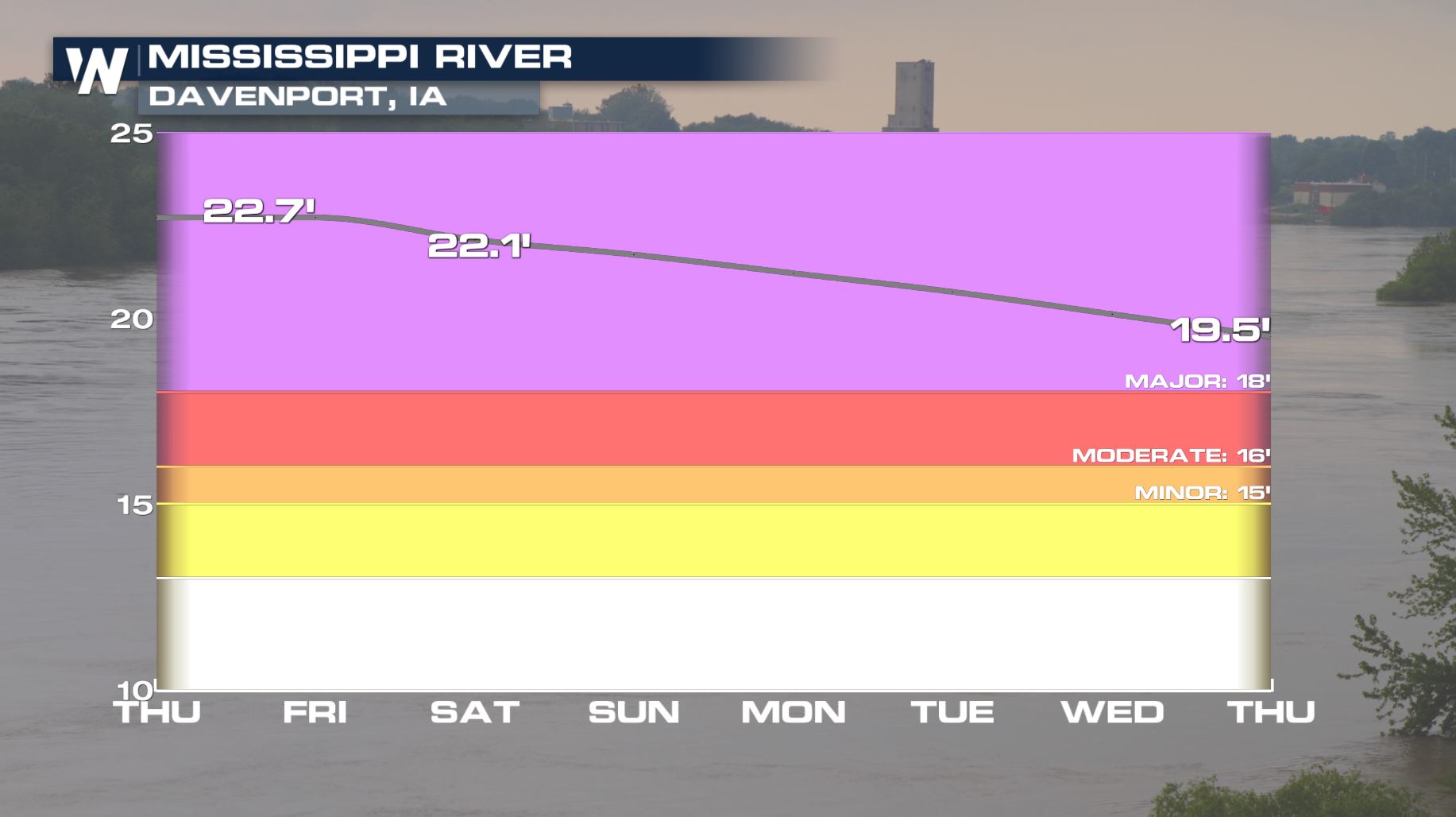 Valid through Thursday, May 9
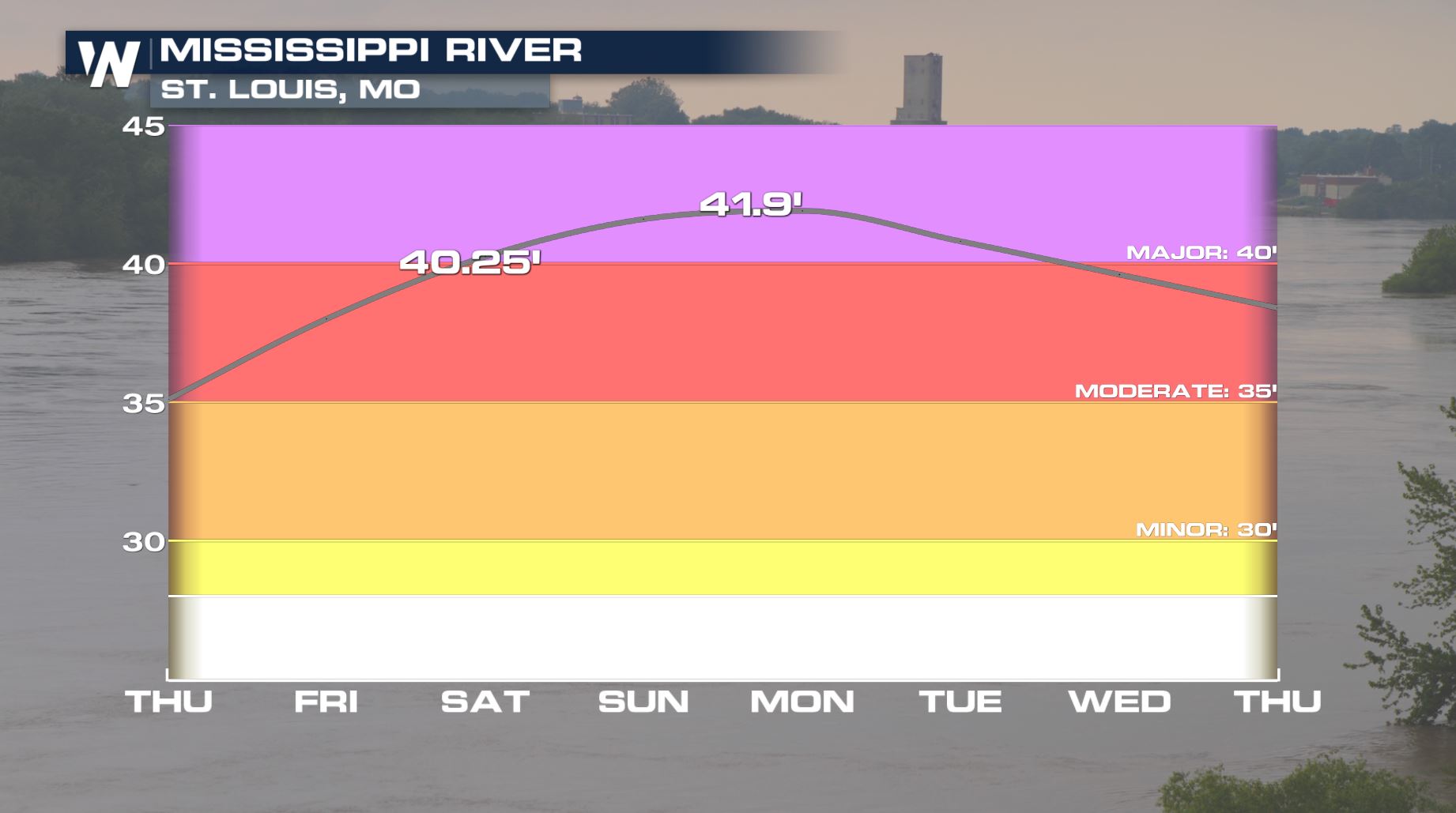
However what goes down, must go up. In this case, as the water drops upstream in Davenport, Iowa it will be rising downstream at St. Louis, Missouri.
Valid through Thursday, May 9
However what goes down, must go up. In this case, as the water drops upstream in Davenport, Iowa it will be rising downstream at St. Louis, Missouri.
 Valid through Thursday, May 9
The Mississippi River is not alone here. Other larger tributaries including the Ohio River, Missouri River and Red River of the North have been swollen to major levels since March due to heavy winter snowfall and heavy spring rainfall.
Valid through Thursday, May 9
The Mississippi River is not alone here. Other larger tributaries including the Ohio River, Missouri River and Red River of the North have been swollen to major levels since March due to heavy winter snowfall and heavy spring rainfall.
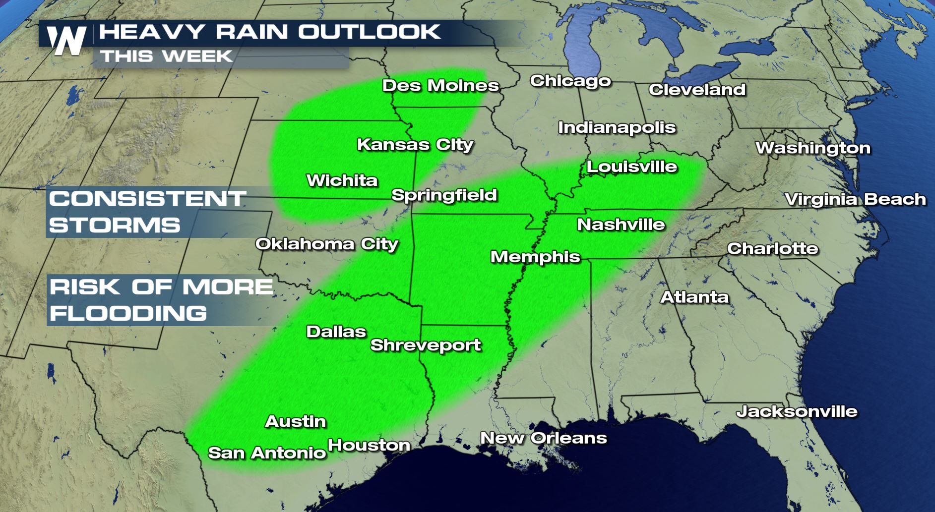
 There's unfortunate news coming this week too. Heavy and consistent thunderstorms are forecast Sunday, Monday, Tuesday, Wednesday and Thursday across various parts of the central U.S. regions.
 Already water-logged areas could be in for more of the same; river flooding. We will update you with any changing information in the days to come.
For WeatherNation, Meteorologist Steve Glazier
Already water-logged areas could be in for more of the same; river flooding. We will update you with any changing information in the days to come.
For WeatherNation, Meteorologist Steve Glazier
The purple dots above correspond to forecast river levels through the early part of the week of May 6th, 2019. This is where water will rise to levels high enough to cause widespread impacts. A majority of these purple dots hover near the Mississippi River, running north to south across the midsection of the country.
Last week the Quad Cities experienced never-before-recorded water levels when the river gauge hit 22.7 feet. Major flood stage here begins at 18.0 feet and it rose nearly 5 feet above that! Fortunately the river forecast in Davenport is promising, showing a slow but steady drop in the water level.
Valid through Thursday, May 9
However what goes down, must go up. In this case, as the water drops upstream in Davenport, Iowa it will be rising downstream at St. Louis, Missouri.
Valid through Thursday, May 9
The Mississippi River is not alone here. Other larger tributaries including the Ohio River, Missouri River and Red River of the North have been swollen to major levels since March due to heavy winter snowfall and heavy spring rainfall.
There's unfortunate news coming this week too. Heavy and consistent thunderstorms are forecast Sunday, Monday, Tuesday, Wednesday and Thursday across various parts of the central U.S. regions.
Already water-logged areas could be in for more of the same; river flooding. We will update you with any changing information in the days to come.
For WeatherNation, Meteorologist Steve GlazierAll Weather News
More
Severe Storms Target the Midwest to the Northeast
UPPER MIDWEST - Dangerous tornadoes have alre
28 Jul 2026 1:45 AM

Tropics: Fausto Heads towards Hawaii; Genevieve Cat 4 Hurricane
PacificHurricane Fausto continues to track we
28 Jul 2026 1:45 AM


Southeast Flood Risk Lingers Near Stalled Front
A stalled boundary over the Southeast will ke
25 Jul 2026 10:55 AM

Another Round of Storms Targets the Northeast
Tuesday brought severe weather again across p
23 Jul 2026 1:15 AM

Another Round of Severe Weather for the Upper Midwest and Great Lakes
The upper-level low train continues to keep t
21 Jul 2026 1:45 AM