NOAA Marks The Return of La Niña
Special Stories
16 Oct 2021 3:15 PM
FROM NOAA.GOV:
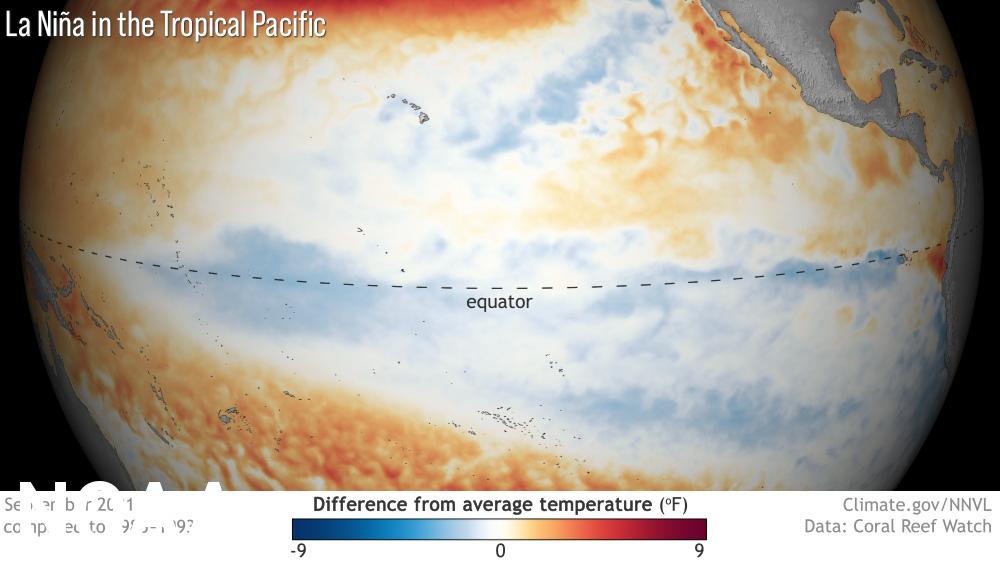
A La Niña has developed and will extend through the second winter in a row according to NOAA’s Climate Prediction Center — a division of NOAA's National Weather Service. La Niña is a natural ocean-atmospheric phenomenon marked by cooler-than-average sea surface temperatures across the central and eastern Pacific Ocean near the equator and is translated from Spanish as “little girl.”
https://www.youtube.com/watch?v=JEaDk1LpNHI
La Niña is one part of the El Niño Southern Oscillation (ENSO) cycle, which is characterized by opposing warm and cool phases of oceanic and atmospheric conditions in the tropical Pacific Ocean. Consecutive La Niñas following a transition through ENSO neutral conditions are not uncommon and can be referred to as a “double-dip.” In 2020, La Niña developed during the month of August and then dissipated in April 2021 as ENSO-neutral conditions returned.
“Our scientists have been tracking the potential development of a La Niña since this summer, and it was a factor in the above-normal hurricane season forecast, which we have seen unfold,” said Mike Halpert, deputy director of NOAA’s Climate Prediction Center. “La Niña also influences weather across the country during the winter, and it will influence our upcoming temperature and precipitation outlooks.”
This La Niña is expected to last through the early spring 2022. For the upcoming winter season, which extends from December 2021 through February 2022, there is an 87% chance of La Niña. Because of these persisting conditions, the Climate Prediction Center has issued a La Niña Advisory.
 Previous La Niñas occurred during the winter of 2020-2021 and 2017-2018, and an El Niño developed in 2018-2019. When neither climate pattern is present, ENSO is neutral and does not influence global climate patterns.
On October 21, NOAA’s Climate Prediction Center will announce the U.S. temperature and precipitation outlook for winter, extending from December 2021 through February 2022. Here's a look at what a typical La Niña pattern looks like in the winter for the lower 48:
Previous La Niñas occurred during the winter of 2020-2021 and 2017-2018, and an El Niño developed in 2018-2019. When neither climate pattern is present, ENSO is neutral and does not influence global climate patterns.
On October 21, NOAA’s Climate Prediction Center will announce the U.S. temperature and precipitation outlook for winter, extending from December 2021 through February 2022. Here's a look at what a typical La Niña pattern looks like in the winter for the lower 48:
 Stay with WeatherNation for updates on what you can expect this winter.
Previous La Niñas occurred during the winter of 2020-2021 and 2017-2018, and an El Niño developed in 2018-2019. When neither climate pattern is present, ENSO is neutral and does not influence global climate patterns.
On October 21, NOAA’s Climate Prediction Center will announce the U.S. temperature and precipitation outlook for winter, extending from December 2021 through February 2022. Here's a look at what a typical La Niña pattern looks like in the winter for the lower 48:
Stay with WeatherNation for updates on what you can expect this winter.All Weather News
More
Wildfire Outbreak in the Pacific Northwest
SPOKANE, WA - On Saturday, August 1st, the Ol
3 Aug 2026 1:55 AM

More Storms for the East Through Monday
A low-pressure system that moved through the
3 Aug 2026 1:50 AM


After Reaching Category 5, Genevieve Weakens in the Pacific
PacificGenevieve formed last Friday south of
3 Aug 2026 12:30 AM

Flooding, Severe Storms Target the Midwest Again
After an active week of storms across the nor
1 Aug 2026 1:40 AM

Flooding Risk Increases as Heavy Rain Targets the Tri-State Area
Tuesday, heavy rainfall moved across the Nort
30 Jul 2026 12:25 AM

Severe Weather: Energy From the Midwest Now in the Southeast
UPPER MIDWEST - Through Monday, dangerous tor
29 Jul 2026 10:30 PM