NOAA Predicts Above Average 2025 Hurricane Season

The mark of 2024’s Atlantic Hurricane Season will be felt for years. But as communities across the southeast continue the rebuilding process, forecasters must look ahead to the upcoming season to help plan and prepare for what’s to come.
Atlantic Hurricane season starts June 1 and runs through November. NOAA released their forecast for what to expect during that time, calling for a slightly above average season.
NOAA anticipates between 13 - 19 named storms and 6 - 10 hurricanes. Of which, 3 - 5 are forecast to become major hurricanes, Category 3 or stronger.
This year is expected to be above average thanks to warm sea surface temperatures in the tropical Atlantic. Although we aren’t expecting the same extreme, record-breaking ocean heat from the last two years.
While ENSO Neutral conditions are forecast to develop this summer, La Niña conditions that traditionally support tropical development could sneak back in by the fall. Despite uncertainty, forecasters feel that the lack of El Nino conditions is enough to warrant an active forecast.
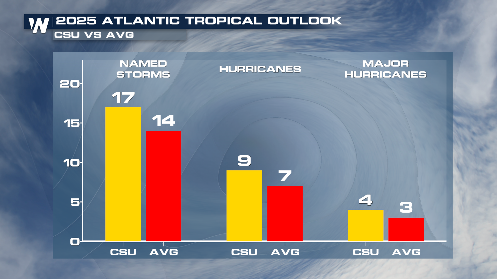
The forecast is aligned with that of Colorado State University which also calls for a slightly above average season.
 As a reminder, these forecasts only account for the total number of storms, NOT potential paths or U.S. impacts. It only takes one storm to impact you and the time to prepare is now.
CENTRAL PACIFIC HURRICANE SEASON OUTLOOK
NOAA’s Central Pacific Hurricane Center and Climate Prediction Center announced a 30% chance of below-normal tropical cyclone activity for the upcoming central Pacific Hurricane Season. The 2025 outlook also indicates a 50% chance of a near-normal hurricane season and a 20% chance that it will be above-normal.
In terms of storm numbers, the forecast calls for 1-4 tropical cyclones across the central Pacific, which is located north of the equator between 140°W and the International Date Line. A near-normal season has 4 or 5 tropical cyclones. Tropical cyclones include tropical depressions, tropical storms and hurricanes.
The outlook is a guide to the overall seasonal tropical cyclone activity in the central Pacific basin and does not predict whether or how many of these systems will affect Hawaii.
The central Pacific hurricane season begins June 1 and runs through November 30.
“Even though this season is predicted to be less active, now is the time for residents and businesses to prepare for hurricane season,” said Chris Brenchley, NOAA Central Pacific Hurricane Center director.
Forecast and communication improvements this season
NOAA’s Central Pacific Hurricane Center and National Hurricane Center are extending forecasts a day earlier on the sustained hurricane-force wind field (74 miles per hour) from 48 to 72 hours.
New this year, the Central Pacific Hurricane Center and National Hurricane Center will be able to issue potential tropical cyclone advisory products up to 72 hours before the anticipated arrival of storm surge or tropical-storm-force winds on land, giving communities more time to prepare. Storm surge is the water pushed onto shore by the winds swirling around a hurricane.
Beginning this year, the National Weather Service will provide storm surge flooding forecasts for the main Hawaiian Islands (Kauai County, Oahu, Maui County, and Hawaii County) so that county emergency managers can better warn coastal residents and businesses.
For more on storm preparation, tropical conditions and alerts, stay with WeatherNation throughout the hurricane season.


