NOAA Releases Spring Outlook
Special Stories
20 Mar 2021 2:55 PM
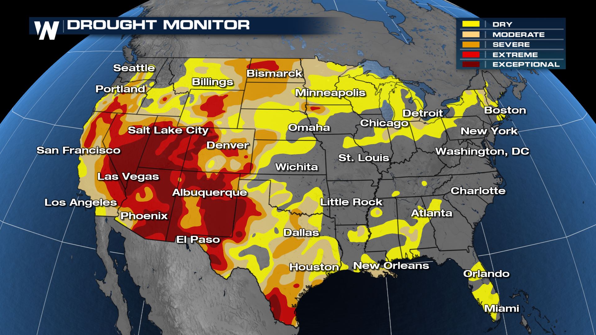
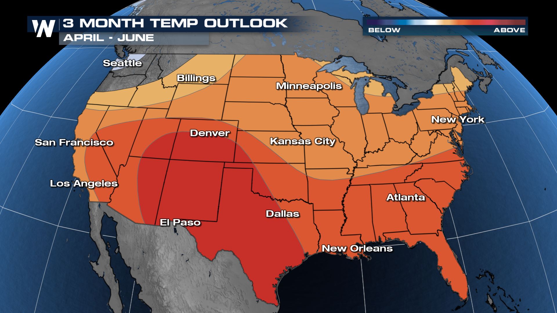
NOAA released its Spring Outlook for the U.S. on Thursday, March 18th. Major flooding is not expected for the first time in three years, but this is due to the ongoing and exceptional drough conditions across much of the lower 48. It projects drought to continue and expand through the Midwest, with warner than normal temperatures expected through late Spring and early Summer.
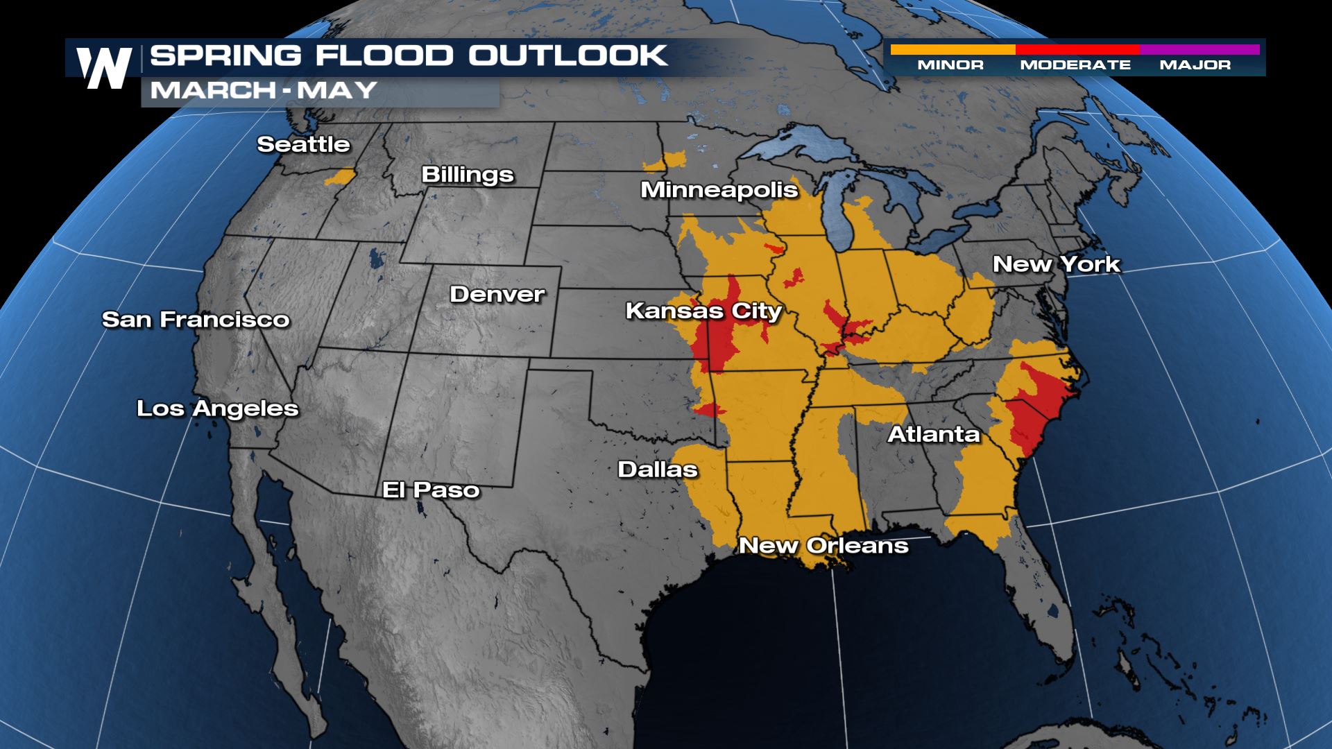 Due to heavy rain from late Februrary through mid-March, flooding and elevated stream flows have been seen in areas of the Midwest, per NOAA. Heavy rainfall events could lead to flood conditions over these saturated soils. The Coastal Plain of the Carolinas, as well as the Lower Missouri and Lower Ohio River basins, which are currently experiencing flooding, have an elevated risk of minor to moderate flooding, according to the NOAA forecast.
According to NOAA, a reduced flood risk exists for the majority of the Greater Mississippi River Basin, Red River of the North, and Souris Basins, due to abnormally dry conditions, ongoing drought, and a lack of snowpack and associated water equivalent.
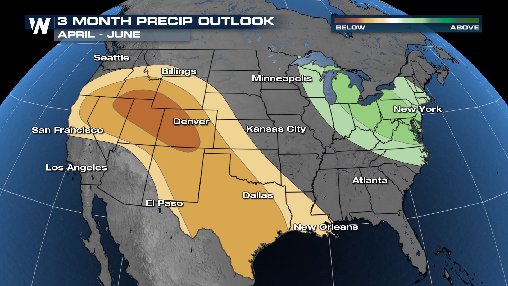
 Per the expected drought, precipitation will be less than average for the southern Plains and much of the West, whereas the Midwest, the Great Lakes, the Mid-Atlantic and Hawaii are projected to see above normal precip over the next few months, according to NOAA. It follows, that drought conditions should be reduced in those areas.
Drought Outlook
The Midwest is currently experiencing moderate to exceptional drought, and those conditions are expected to continue and expand into the coming months, per NOAA. NOAA says, the La Niña pattern and lack of moisture during the 2020 monsoon season are contributing to the most significant drought since 2013."The Southwest U.S., which is already experiencing widespread severe to exceptional drought, will remain the hardest hit region in the U.S., and water supply will continue to be a concern this spring in these drought-affected areas," said Mary Erickson, deputy director of the National Weather Service. "This is a major change from recent years where millions were impacted by severe flooding. Nonetheless, NOAA's forecasts and outlooks will continue to serve as a resource for emergency managers and community decision-makers as they navigate all potential extreme seasonal weather and water events."The drought is expected to expand into the Great Plains and south Florida due to warmer-than-average temperatures and low soil moisture. The drought could become more severe for the northern Great Plains if we lack below average spring precipitation, according to NOAA. NOAA says, drought improvement is expected over the next few months in the: Pacific Northwest, Midwest, New England and Hawaii.

Spring Flood Risk
NOAA hydrologists are NOT forecasting any areas of major flooding for the first time in 3 years! Widespread minor to moderate flooding is predicted across the Mississippi River and into the Coastal Plain of the Carolinas. Overall, this flood year is not expected to be severe or as prolonged as the previous two years. Due to heavy rain from late Februrary through mid-March, flooding and elevated stream flows have been seen in areas of the Midwest, per NOAA. Heavy rainfall events could lead to flood conditions over these saturated soils. The Coastal Plain of the Carolinas, as well as the Lower Missouri and Lower Ohio River basins, which are currently experiencing flooding, have an elevated risk of minor to moderate flooding, according to the NOAA forecast.
According to NOAA, a reduced flood risk exists for the majority of the Greater Mississippi River Basin, Red River of the North, and Souris Basins, due to abnormally dry conditions, ongoing drought, and a lack of snowpack and associated water equivalent.
“Our national hydrologic assessment helps to inform the Nation where there will likely be too much or too little water. This spring, we anticipate a reduced risk for flooding, and forecast significantly below average water supply where impacts due to low flow contribute to the continued drought,” said Ed Clark, director of NOAA’s National Water Center in Tuscaloosa, Alabama.Water supply forecasts through spring are predicted to be below to much below normal for most of the desert southwest, southern Oregon, and southern Idaho into much of the Rocky Mountains, which will play a major role in drought persistence this spring.
Temperature and Precipitation Outlook
According to NOAA, warmer-than-normal temperatures are expected for the entire lower-48 (outside of central and western states bordering Canada). Hawaii, along with parts of Alaska are also projected to see above average temperatures too. Per the expected drought, precipitation will be less than average for the southern Plains and much of the West, whereas the Midwest, the Great Lakes, the Mid-Atlantic and Hawaii are projected to see above normal precip over the next few months, according to NOAA. It follows, that drought conditions should be reduced in those areas.

All Weather News
More