Nor’easters Pummel the U.S. Northeast in This Winter

Special Stories
15 Mar 2018 9:11 AM
[Beacon Street in Boston from Tuesday. Image credit: Prataap Patrose via Storyful/Instagram] From NOAA by Tom Di Liberto Between the end of February and early March 2018, a series of massive storm systems called nor’easters have brought strong winds, heavy snow, and tremendous coastal flooding to communities from the Mid-Atlantic to northern Maine. While these storms are not out of the ordinary—they happen every winter—their strength and close timing certainly has been newsworthy. https://youtu.be/df2PjHpDUzU On March 2-3, a nor’easter moved along the east coast, rapidly strengthening as it crossed the warm waters of the Gulf Stream. As the storm did so, it gathered plenty of moisture, which it transformed into heavy snow like some sort of winter factory line. https://twitter.com/NWSBoston/status/973983932583698433 As the storm strengthened, the winds began to howl. Wind speeds are tied to the difference in pressure between two areas. The bigger the pressure difference, the stronger the winds. As the difference in pressure between the storm’s low pressure center and the higher pressures surrounding it maxed out, wind speeds increased accordingly. Winds gusted to 93 miles per hour (mph) in Barnstable, Massachusetts, closer to the center of the storm. But winds were strong hundreds of miles away. In Washington DC, winds gusted to 66 mph at the U.S. Capitol. In Kentucky, winds reached 48 mph in Lexington. In Ohio, winds gusted to nearly 50 mph in Cleveland. In South Carolina, wind gusts topped out at 55 mph in Tryon. Over two million people lost power.
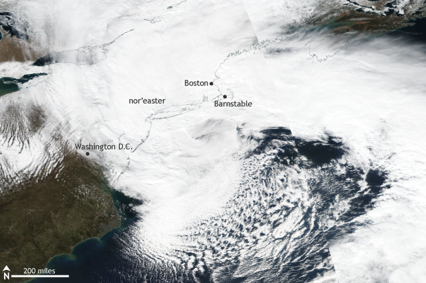 [Suomi NPP satellite image taken of the eastern United States on March 2, 2018 using the VIIRS instrument. A massive nor'easter brought heavy snow and damaging winds to a broad area across the East Coast. NOAA Climate image using data provided by NASA Worldview.]
With winds this strong blowing onshore across much of the East Coast, coastal flooding was inevitable. But what made this event so spectacular was just how high waters got and how long coastal waters remained elevated in Massachusetts and Maine.
Water levels in Boston reached the third highest on record, a 1-in-100-year water height—which means that there is a 1% chance in any given year that waters level would reach that high. More remarkable, the number one and three spots in Boston’s record books are now occupied by water levels reached during two storms this winter.
[Suomi NPP satellite image taken of the eastern United States on March 2, 2018 using the VIIRS instrument. A massive nor'easter brought heavy snow and damaging winds to a broad area across the East Coast. NOAA Climate image using data provided by NASA Worldview.]
With winds this strong blowing onshore across much of the East Coast, coastal flooding was inevitable. But what made this event so spectacular was just how high waters got and how long coastal waters remained elevated in Massachusetts and Maine.
Water levels in Boston reached the third highest on record, a 1-in-100-year water height—which means that there is a 1% chance in any given year that waters level would reach that high. More remarkable, the number one and three spots in Boston’s record books are now occupied by water levels reached during two storms this winter.
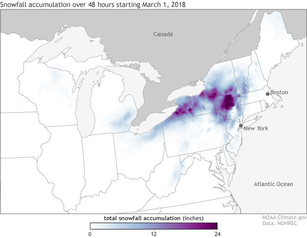
[48 hour snowfall accumulations starting on March 1, 2018 taken from the National Snowfall Analysis produced by the National Operational Hydrologic Remote Sensing Center (NOHRSC). A nor'easter brought heavy snow to interior portions of the northeast. NOAA Climate image using data from NOHRSC.]
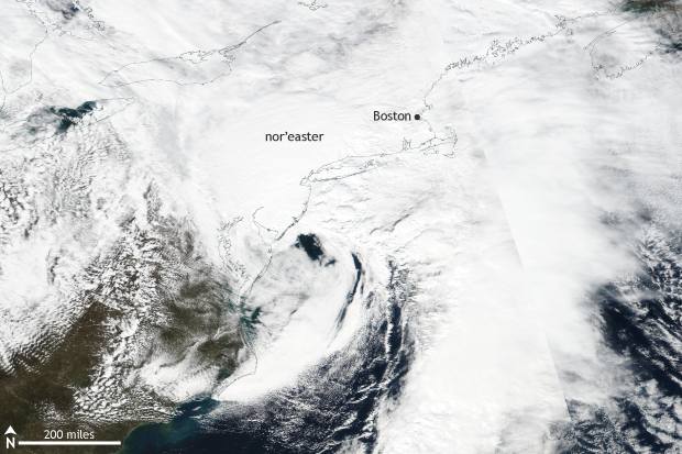
Suomi NPP satellite image taken of the eastern United States on March 7, 2018 using the VIIRS instrument. Less than a week after major nor'easter impacted the East Coast, a second storm pummeled the region dropping one to two feet of snow. NOAA Climate.gov image using data provided by NASA Worldview.
What does the future hold for nor’easters?
When it comes to average winter snowfall in the contiguous United States, global warming will mean less of it, basically everywhere, eventually. Averaged across the Northern Hemisphere, snow extent is already declining. But between now and eventually, there’s room for a variety of impacts on individual storms in different parts of the world.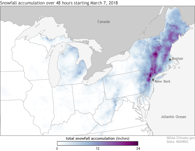
[48 hour snowfall accumulations starting on March 7, 2018 taken from the National Snowfall Analysis produced by the National Operational Hydrologic Remote Sensing Center (NOHRSC). A nor'easter dropped feet of snow across a broad area of the northeast. NOAA Climate image using data from NOHRSC.]
But what about the storms?
This is where my answer gets murky. The National Climate Assessment notes that for the entire Northern Hemisphere, there has been an increase in both the number and strength of storms during colder months since 1950. In particular, extremely heavy snowstorms have increased in number over the last century in northern and eastern parts of the United States. These types of extreme events have been less frequent since 2000. Our ability to explain why, physically, these trends have occurred, however is low (Vose et al. 2013).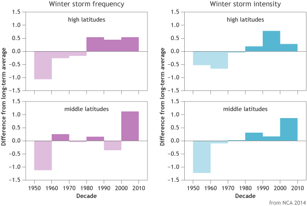
[Frequency and intensity of winter storms in high (60-90°N) and mid-latitudes (30-60°N) between 1949-2010 compared to the long-term average. Storm frequencies have increased in middle and high latitudes, and storm intensities have increased in middle latitudes. Graph adapted from National Climate Assessment 2014.]
All Weather News
More
Severe Storms in the Midwest Could Dampen Holiday Plans
NORTHERN PLAINS - A frontal system is expecte
4 Jul 2025 3:20 AM

Near Seasonal Temperatures for Many Come July 4th!
AAA is expecting over 70 million travelers to
4 Jul 2025 3:15 AM

NHC Monitoring Front in the Southeast Ahead of 4th of July
Tropical downpours for a long holiday weekend
4 Jul 2025 3:10 AM

Flossie is No More, Eastern Pacific Remains Active
Post Tropical FlossieThe National Hurricane C
4 Jul 2025 3:05 AM


Northwest Heat Met With Thunderstorm Risk
NORTHWEST - Today, portions of Montana are un
3 Jul 2025 12:00 AM

Severe Weather Threat Continues in the Midwest
It has been an active, severe season across t
30 Jun 2025 9:00 PM