October Recap: Plenty of Warmth and a Record Setting West Coast Storm

Special Stories
11 Nov 2021 6:20 PM
[A view from NOAA’s GOES-17 satellite of a “bomb cyclone” approaching the Pacific Northwest of the United States on October 24, 2021. This powerful storm set a record-low pressure reading for this part of the Pacific Ocean. (NOAA Satellites)]
[Written by NOAA and NOAA NCEI] October 2021 was an unusually balmy month for the contiguous U.S., as several states recorded their warmest October on record.
Abundant Pacific moisture also dumped excessive rainfall over the western U.S. that created hazardous flood conditions in some places but helped snuff out some wildfire activity in the West.
Here are more highlights from NOAA’s latest monthly U.S. climate report:
Climate by the numbers
October 2021
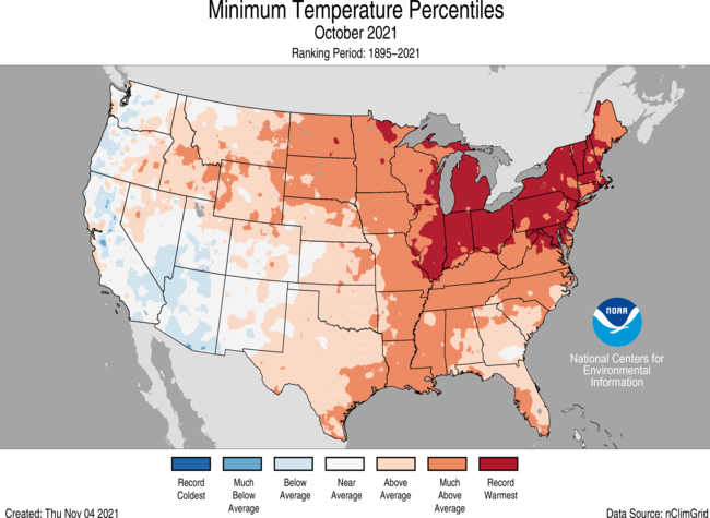
 The average October temperature across the contiguous U.S. was 57.0 degrees F, 2.9 degrees above the 20th-century average, making it the sixth-warmest October in 127 years.
Several states ranked even higher on record for heat. Maryland and Ohio had their warmest October on record, while Delaware, Maine, Massachusetts, New Jersey, Pennsylvania and Rhode Island each saw their second-warmest October. Temperatures were below average across portions of the West Coast and Southwest.
The average October temperature across the contiguous U.S. was 57.0 degrees F, 2.9 degrees above the 20th-century average, making it the sixth-warmest October in 127 years.
Several states ranked even higher on record for heat. Maryland and Ohio had their warmest October on record, while Delaware, Maine, Massachusetts, New Jersey, Pennsylvania and Rhode Island each saw their second-warmest October. Temperatures were below average across portions of the West Coast and Southwest.
 The average precipitation was 3.11 inches — 0.95 of an inch above average — making it the ninth-wettest October.
Above-average precipitation was observed across parts of the West, Plains, Great Lakes, Midwest, Southeast and Northeast. California and Illinois both saw their fourth-wettest October on record.
Conveyor belts of Pacific moisture, defined as atmospheric rivers, impacted much of the central West Coast from October 19-26. On October 24, a Category 5 (exceptional) atmospheric river event brought record rainfall to parts of central California. The heavy rain near wildfire burn scars triggered multiple landslides, yet helped partially snuff out the wildfire season and lessened the drought severity across this portion of the West.
Sacramento, CA, set a record of 211 days without measurable precipitation in 2021. This streak ended on October 17. On October 24, 5.45 inches of rainfall was recorded in Sacramento, breaking the previous single-day precipitation record of 5.28 inches, set in 1880.
The East Coast experienced an early fall Nor’easter. On October 26, high winds and heavy rainfall led to flash flooding and power outages from New Jersey to Massachusetts.
Year to date (YTD) | January through October 2021
The average precipitation was 3.11 inches — 0.95 of an inch above average — making it the ninth-wettest October.
Above-average precipitation was observed across parts of the West, Plains, Great Lakes, Midwest, Southeast and Northeast. California and Illinois both saw their fourth-wettest October on record.
Conveyor belts of Pacific moisture, defined as atmospheric rivers, impacted much of the central West Coast from October 19-26. On October 24, a Category 5 (exceptional) atmospheric river event brought record rainfall to parts of central California. The heavy rain near wildfire burn scars triggered multiple landslides, yet helped partially snuff out the wildfire season and lessened the drought severity across this portion of the West.
Sacramento, CA, set a record of 211 days without measurable precipitation in 2021. This streak ended on October 17. On October 24, 5.45 inches of rainfall was recorded in Sacramento, breaking the previous single-day precipitation record of 5.28 inches, set in 1880.
The East Coast experienced an early fall Nor’easter. On October 26, high winds and heavy rainfall led to flash flooding and power outages from New Jersey to Massachusetts.
Year to date (YTD) | January through October 2021
 The average U.S. temperature for the YTD was 57.0 degrees F, 2.0 degrees above the 20th-century average, making it the ninth-warmest such period in the climate record.
Maine saw its second-warmest YTD on record, while New Hampshire and Vermont had their third warmest. In contrast, temperatures this year so far ran below average across parts of the Deep South.
The average U.S. temperature for the YTD was 57.0 degrees F, 2.0 degrees above the 20th-century average, making it the ninth-warmest such period in the climate record.
Maine saw its second-warmest YTD on record, while New Hampshire and Vermont had their third warmest. In contrast, temperatures this year so far ran below average across parts of the Deep South.
 The U.S. precipitation total for the YTD was 26.74 inches — 1.38 inches above average — which placed in the wettest third of the record. Massachusetts and Mississippi had a third-wettest YTD, while Louisiana saw its fourth wettest.
Precipitation was below average across portions of the West, northern Plains, Great Lakes and New England. Montana saw its fourth-driest YTD on record.
Other notable climate events in October
The U.S. precipitation total for the YTD was 26.74 inches — 1.38 inches above average — which placed in the wettest third of the record. Massachusetts and Mississippi had a third-wettest YTD, while Louisiana saw its fourth wettest.
Precipitation was below average across portions of the West, northern Plains, Great Lakes and New England. Montana saw its fourth-driest YTD on record.
Other notable climate events in October

The average October temperature across the contiguous U.S. was 57.0 degrees F, 2.9 degrees above the 20th-century average, making it the sixth-warmest October in 127 years.
Several states ranked even higher on record for heat. Maryland and Ohio had their warmest October on record, while Delaware, Maine, Massachusetts, New Jersey, Pennsylvania and Rhode Island each saw their second-warmest October. Temperatures were below average across portions of the West Coast and Southwest.
The average precipitation was 3.11 inches — 0.95 of an inch above average — making it the ninth-wettest October.
Above-average precipitation was observed across parts of the West, Plains, Great Lakes, Midwest, Southeast and Northeast. California and Illinois both saw their fourth-wettest October on record.
Conveyor belts of Pacific moisture, defined as atmospheric rivers, impacted much of the central West Coast from October 19-26. On October 24, a Category 5 (exceptional) atmospheric river event brought record rainfall to parts of central California. The heavy rain near wildfire burn scars triggered multiple landslides, yet helped partially snuff out the wildfire season and lessened the drought severity across this portion of the West.
Sacramento, CA, set a record of 211 days without measurable precipitation in 2021. This streak ended on October 17. On October 24, 5.45 inches of rainfall was recorded in Sacramento, breaking the previous single-day precipitation record of 5.28 inches, set in 1880.
The East Coast experienced an early fall Nor’easter. On October 26, high winds and heavy rainfall led to flash flooding and power outages from New Jersey to Massachusetts.
Year to date (YTD) | January through October 2021
The average U.S. temperature for the YTD was 57.0 degrees F, 2.0 degrees above the 20th-century average, making it the ninth-warmest such period in the climate record.
Maine saw its second-warmest YTD on record, while New Hampshire and Vermont had their third warmest. In contrast, temperatures this year so far ran below average across parts of the Deep South.
The U.S. precipitation total for the YTD was 26.74 inches — 1.38 inches above average — which placed in the wettest third of the record. Massachusetts and Mississippi had a third-wettest YTD, while Louisiana saw its fourth wettest.
Precipitation was below average across portions of the West, northern Plains, Great Lakes and New England. Montana saw its fourth-driest YTD on record.
Other notable climate events in October
- Pacific Northwest smacked by record bomb cyclone: An all-time record low pressure system for the region developed in the eastern Pacific and strengthened rapidly on October 24, generating hurricane force winds and wave heights up to 45 feet off the coast of Washington and Oregon. Wind gusts toppled trees and knocked out power around the Seattle metro area and Puget Sound.
- Atmospheric river deluged the West Coast: Conveyor belts of Pacific moisture, known as atmospheric rivers, impacted much of the central West Coast from October 19-26. On October 24, a Category 5 (exceptional) atmospheric river event brought record rainfall to portions of central California. Sacramento, Blue Canyon and Santa Rosa each reported their wettest 24-hour period on record. The heavy rain near wildfire burn scars triggered multiple landslides, but helped to partially quench the wildfire season and drought severity across parts of the West.
- Tornadoes touched down: Preliminary tornado counts across the U.S. during October were the second most on record for the month with a count of 146. Only preliminary counts in 2018 ranked higher with 159 tornadoes reported. Oklahoma reported a record 31 tornadoes for October, which exceeds the previous record of 27 set in 1998.
- A persistent ridge of high pressure across the eastern U.S. contributed to the record warm October temperatures observed in locations spanning from Milwaukee to New Haven, CT. Record-warm mild nights were observed from the Great Lakes to southern New England and were the main driver for these warm monthly temperatures.
All Weather News
More

Western Heat Continues With Some Relief
A large dome of hot high pressure remains acr
1 Jul 2025 11:00 PM

NHC Monitoring Front in the Southeast Ahead of 4th of July
SOUTHEAST - A frontal boundary moving through
1 Jul 2025 10:35 PM

Severe Storms For the East Coast Through Tuesday
A cold front is tapping into a moist air mass
1 Jul 2025 10:20 PM

Where Rain Could Dampen Holiday Travel Plans
AAA is expecting over 70 million travelers to
1 Jul 2025 4:35 PM

Severe Weather Threat Continues in the Midwest
It has been an active, severe season across t
30 Jun 2025 9:00 PM

Thunderstorms Possible in the Southeast Overnight
SOUTHEAST - Strong thunderstorms have develop
28 Jun 2025 2:40 AM