One Step Closer to Full Operations: GOES-17 “Beta” Data Set for Release Soon
Special Stories
30 Aug 2018 8:50 AM
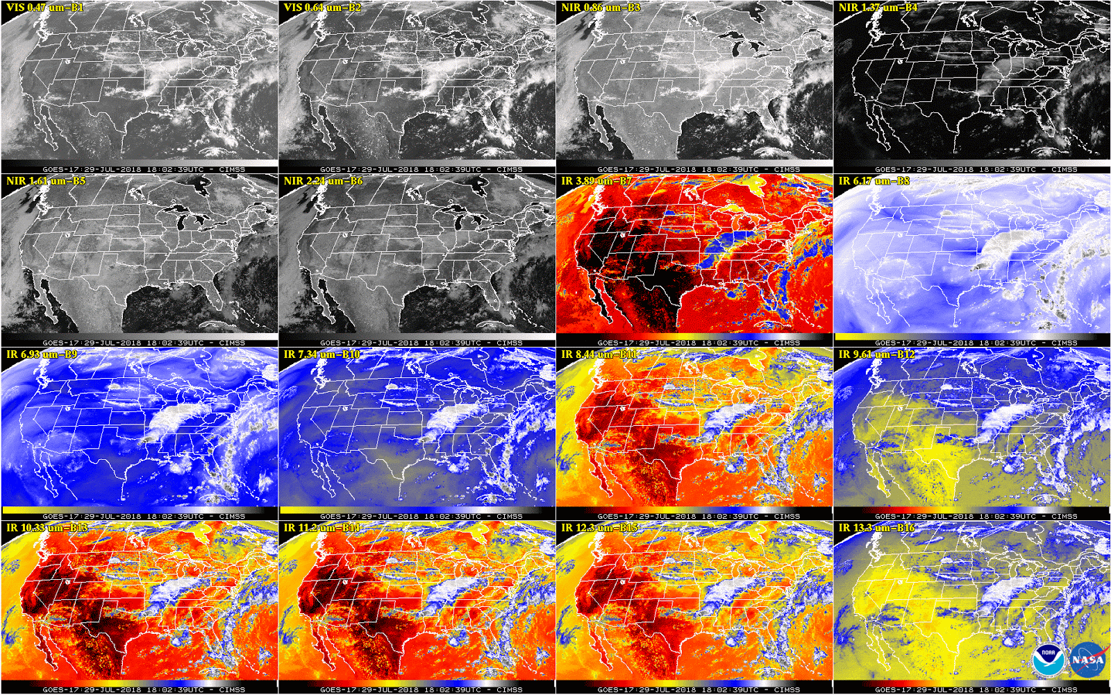
[This 16-panel image shows a snapshot of the continental U.S. and surrounding oceans from each of the Advanced Baseline Imager channels on July 29. This imagery was captured between the instrument’s “cool” and “warm” season, when all 16 channels are available 24 hours per day. During the instrument’s “warm” seasons, varied data outages are expected for 9 of the channels during nighttime hours. The ABI’s increased channels provide three times more spectral information than the previous GOES imager. Credit: NOAA/NASA]
From NOAA
This week, NOAA is releasing GOES-17 Advanced Baseline Imager (ABI) “beta” level data and imagery—data which are still preliminary and not yet fully ready for use--to forecasters and scientific partners. This is an important step in making sure that GOES-17 is ready to do its job of providing timely, accurate data for weather forecasting and environmental monitoring.
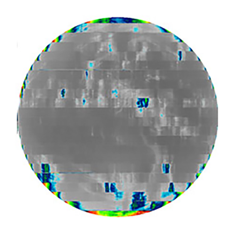 [An example of degraded imagery from August 14 near the time of peak detector temperatures. Band 16 is among the first to degrade when the detectors warm up; other IR bands are still fine at the higher temperatures.]
This is especially important in the case of GOES-17, since we know that some of the data, at certain times of the year, may be of lesser quality due to problems with the ABI loop heat pipe. By distributing this data, NOAA is providing the community of users the opportunity to understand the ABI data quality and to prepare to use the data operationally.
[An example of degraded imagery from August 14 near the time of peak detector temperatures. Band 16 is among the first to degrade when the detectors warm up; other IR bands are still fine at the higher temperatures.]
This is especially important in the case of GOES-17, since we know that some of the data, at certain times of the year, may be of lesser quality due to problems with the ABI loop heat pipe. By distributing this data, NOAA is providing the community of users the opportunity to understand the ABI data quality and to prepare to use the data operationally.
Why is NOAA releasing this data?
In order to get ready to use data from GOES-17 (or any new satellite) for 24/7 operations, forecasters and scientists need an opportunity to test their data flow mechanisms and to see how to incorporate the data into science products and forecasting processes.
[An example of degraded imagery from August 14 near the time of peak detector temperatures. Band 16 is among the first to degrade when the detectors warm up; other IR bands are still fine at the higher temperatures.]
This is especially important in the case of GOES-17, since we know that some of the data, at certain times of the year, may be of lesser quality due to problems with the ABI loop heat pipe. By distributing this data, NOAA is providing the community of users the opportunity to understand the ABI data quality and to prepare to use the data operationally.
What will the scientists see?
Most of the data coming from GOES-17 has been excellent. On August 8, several examples of that data was released. However, some of the data will be degraded when it starts to flow because we are in one of the warmest parts of the year for the operation of the satellite. https://www.youtube.com/watch?v=ojoKLYtejrs [This color-enhanced imagery from one of GOES-17’s longwave infrared bands shows convective activity in the western U.S. on July 29. Band 14 is used to characterize atmospheric processes associated with thunderstorms and convective complexes. The cold clouds in this animation (colored red and black) are associated with a storm system that included reports of tornadoes, hail and strong wind. Credit: NOAA/NASA] During the instrument’s “cool” seasons (near the summer and winter solstice), all channels are expected to be available 24 hours per day. During the instrument’s “warm” seasons (before and after the vernal and autumnal equinox), experts estimate 7 channels (bands 1-7) will be available 24 hours per day and the other 9 channels (bands 8-16) will be saturated, with images degraded or unusable 2-6 hours per night. These estimates are preliminary and are still being refined.The bottom line:
Although the cooling system of the GOES-17 ABI is not working as it should, experts have made tremendous progress in improving the operation of the satellite to make the most of its capabilities. That work continues. Releasing the beta data will help scientists and forecasters use the data as effectively as possible. In the meantime, NOAA’s operational geostationary constellation -- GOES-16, operating as GOES-East, GOES-15, operating as GOES-West, and GOES-14, operating as the on-orbit spare -- continues to remain healthy and monitoring weather across the nation each day. Edited for WeatherNation by Meteorologist Mace MichaelsAll Weather News
More


More Storms for the East Sunday and Monday
A low-pressure system crashing through the Mi
2 Aug 2026 2:20 AM

After Reaching Category 5, Genevieve Weakens in the Pacific
PacificGenevieve formed on last Friday south
2 Aug 2026 1:30 AM

Flooding, Severe Storms Target the Midwest Again
After an active week of storms across the nor
1 Aug 2026 1:40 AM

Flooding Risk Increases as Heavy Rain Targets the Tri-State Area
Tuesday, heavy rainfall moved across the Nort
30 Jul 2026 12:25 AM

Severe Weather: Energy From the Midwest Now in the Southeast
UPPER MIDWEST - Through Monday, dangerous tor
29 Jul 2026 10:30 PM