Predicting Hurricane Flooding Risks to the East Coast
Special Stories
10 Apr 2018 8:11 AM
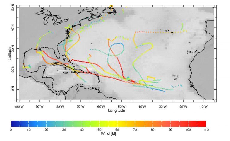
[A random simulation of possible tracks that a hurricane in the Atlantic Ocean could take, from the Hurricane Interactive Track Simulator developed at Columbia’s Lamont-Doherty Earth Observatory. The simulator helps scientists calculate landfall risk along the U.S. coast. With future upgrades, it will also include wind and precipitation information to predict flooding impacts as well. Image: Yochanan Kushnir]
From Columbia University
A model developed at Columbia’s Lamont-Doherty Earth Observatory will soon make its debut in the real world, helping to characterize and predict the paths and impacts of hurricanes on the East Coast.
Columbia University and data-analytics firm Jupiter announced plans to collaborate on improved hurricane track simulations, so that the public and private sectors can plan for weather and climate risks. Columbia’s ground-breaking hurricane and climate science will be added to Jupiter’s ClimateScore Intelligence Platform, which translates research into information that decision-makers can use to manage and mitigate climate change risks. The platform already predicts local probabilities of extreme temperatures and flooding; soon it will include hurricane-related hazards such as heavy winds, rain, and storm surge. As part of the collaboration, Columbia will lead efforts to expand upon their Hurricane Interactive Track Simulator (HITS).
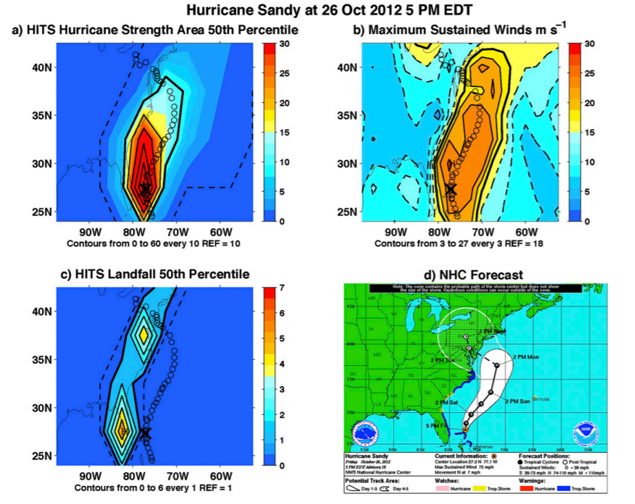 [For Hurricane Sandy, (a) simulated hurricane wind strength area in 6-h time periods per year, (b) maximum sustained winds from 26 Oct to 31 Oct 2012, (c) simulated mainland landfalls, and (d) watch/warning image from the National Hurricane Center at 1700 EDT 26 Oct 2012. Black circles in (a)–(c) indicate the actual path of Hurricane Sandy and a large black X indicates where the simulation was started.]
Currently, the HITS model simulates hurricane tracks and assesses landfall risk along the Atlantic coast of Central and North America. The team will extend the model to include the effects of severe wind and precipitation, which can be used to assess the risk of coastal and inland flooding. This is a critical step toward designing risk management strategies. Jupiter is committing more than $300,000 to the upgrade, and will provide technical support.
“We have over 120 scientists here at Columbia working on cutting-edge research questions relevant to informing climate risks to society, infrastructure and ecosystems,” said Peter deMenocal, founding director of Columbia’s Center for Climate and Life at Lamont-Doherty. “By integrating our scientists and unique data assets with Jupiter’s leading climate technology innovation, this novel partnership can accelerate the knowledge needed to support action in the marketplace.”
Edited for WeatherNation by Meteorologist Mace Michaels
[For Hurricane Sandy, (a) simulated hurricane wind strength area in 6-h time periods per year, (b) maximum sustained winds from 26 Oct to 31 Oct 2012, (c) simulated mainland landfalls, and (d) watch/warning image from the National Hurricane Center at 1700 EDT 26 Oct 2012. Black circles in (a)–(c) indicate the actual path of Hurricane Sandy and a large black X indicates where the simulation was started.]
Currently, the HITS model simulates hurricane tracks and assesses landfall risk along the Atlantic coast of Central and North America. The team will extend the model to include the effects of severe wind and precipitation, which can be used to assess the risk of coastal and inland flooding. This is a critical step toward designing risk management strategies. Jupiter is committing more than $300,000 to the upgrade, and will provide technical support.
“We have over 120 scientists here at Columbia working on cutting-edge research questions relevant to informing climate risks to society, infrastructure and ecosystems,” said Peter deMenocal, founding director of Columbia’s Center for Climate and Life at Lamont-Doherty. “By integrating our scientists and unique data assets with Jupiter’s leading climate technology innovation, this novel partnership can accelerate the knowledge needed to support action in the marketplace.”
Edited for WeatherNation by Meteorologist Mace MichaelsAll Weather News
More

Flooding, Severe Storms Target the Midwest Again
After an active week of storms across the nor
1 Aug 2026 1:40 AM


After Reaching Category 5, Genevieve Weakens in the Pacific
PacificFausto is now a post-tropical cyclone.
31 Jul 2026 1:30 AM

Flooding Risk Increases as Heavy Rain Targets the Tri-State Area
Tuesday, heavy rainfall moved across the Nort
30 Jul 2026 12:25 AM

Severe Weather: Energy From the Midwest Now in the Southeast
UPPER MIDWEST - Through Monday, dangerous tor
29 Jul 2026 10:30 PM