Radar Improvement Helps Forecasters to “See” Storms Better
Special Stories
27 Feb 2019 8:20 AM
[NOAA] Radars are a vital tool for weather forecasters because they provide a detailed picture of storms as they’re happening. A new radar technique is improving the picture for forecasters, helping them provide more accurate information about rain and snow storms.
Developed by researchers at University of Oklahoma Cooperative Institute for Mesoscale Meteorological Studies and NOAA’s National Severe Storms Laboratory, the improvement is now being shared with collaborators an ocean away. The United States-based engineers collaborated with meteorologists at the United Kingdom Met Office on the technique called Radial-by-Radial Noise estimator, or RBRN, to improve radar signal returns in storms.
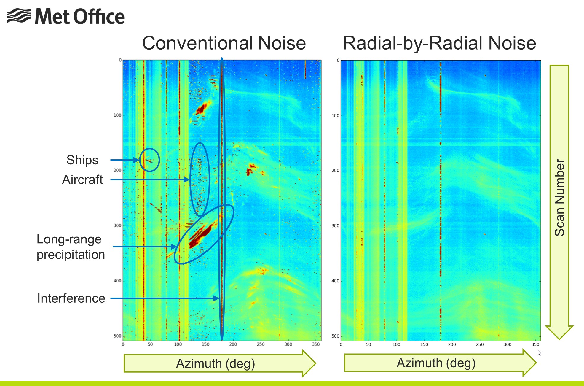 [An example of the RBRN technique. From NSSL and UKMET Office.]
“Through this unique collaboration paradigm, we’ve proven that scientific partnerships can transcend geographical, political and proprietary boundaries,” said Sebastian Torres, CIMMS researcher leading NSSL’s Advanced Radar Techniques Team. “The atmosphere knows no geographical boundaries. Better forecasts in the UK can provide improved information to the United States, and vice versa, as we continue to build partnerships to help save lives, property and minimize the economic impact of severe weather in the U.S.”
Weather radars often pick up noise from various sources like the sun or man-made devices similarly to how a radio or television sometimes retrieve a static signal. The RBRN analyzes radar beam data in real-time and performs several tests to ensure the noise can be detected and measured.
[An example of the RBRN technique. From NSSL and UKMET Office.]
“Through this unique collaboration paradigm, we’ve proven that scientific partnerships can transcend geographical, political and proprietary boundaries,” said Sebastian Torres, CIMMS researcher leading NSSL’s Advanced Radar Techniques Team. “The atmosphere knows no geographical boundaries. Better forecasts in the UK can provide improved information to the United States, and vice versa, as we continue to build partnerships to help save lives, property and minimize the economic impact of severe weather in the U.S.”
Weather radars often pick up noise from various sources like the sun or man-made devices similarly to how a radio or television sometimes retrieve a static signal. The RBRN analyzes radar beam data in real-time and performs several tests to ensure the noise can be detected and measured.
 “Accurate measurement of noise on weather radars is critical as it impacts the accuracy of radar data and plays a key role in data quality control,” Torres said. In addition, a portion of energy from the radar beam may also be absorbed by particles in its path before the radar beam energy is returned.
“This weakens the echoes from locations far from the radar and gives the wrong impression that storms in these locations are weaker than they truly are,” Torres said. “Because the particles in the radar beam path emit noise, the noise measured by RBRN can be used to correct for the weakening or attenuation of echoes as the radar beam intersects storms. The operational RBRN estimator significantly improves the quality of radar data, especially for weak returns associated with snow storms and gust fronts.”
Reducing and accurately measuring contamination from the noise in the radar data equates to better information and more accurate forecasts. The RBRN was originally developed by CIMMS Researcher Igor Ivic and became operational in the U.S. NEXRAD radar network in 2014.
Edited for WeatherNation by Meteorologist Mace Michaels
“Accurate measurement of noise on weather radars is critical as it impacts the accuracy of radar data and plays a key role in data quality control,” Torres said. In addition, a portion of energy from the radar beam may also be absorbed by particles in its path before the radar beam energy is returned.
“This weakens the echoes from locations far from the radar and gives the wrong impression that storms in these locations are weaker than they truly are,” Torres said. “Because the particles in the radar beam path emit noise, the noise measured by RBRN can be used to correct for the weakening or attenuation of echoes as the radar beam intersects storms. The operational RBRN estimator significantly improves the quality of radar data, especially for weak returns associated with snow storms and gust fronts.”
Reducing and accurately measuring contamination from the noise in the radar data equates to better information and more accurate forecasts. The RBRN was originally developed by CIMMS Researcher Igor Ivic and became operational in the U.S. NEXRAD radar network in 2014.
Edited for WeatherNation by Meteorologist Mace Michaels
[An example of the RBRN technique. From NSSL and UKMET Office.]
“Through this unique collaboration paradigm, we’ve proven that scientific partnerships can transcend geographical, political and proprietary boundaries,” said Sebastian Torres, CIMMS researcher leading NSSL’s Advanced Radar Techniques Team. “The atmosphere knows no geographical boundaries. Better forecasts in the UK can provide improved information to the United States, and vice versa, as we continue to build partnerships to help save lives, property and minimize the economic impact of severe weather in the U.S.”
Weather radars often pick up noise from various sources like the sun or man-made devices similarly to how a radio or television sometimes retrieve a static signal. The RBRN analyzes radar beam data in real-time and performs several tests to ensure the noise can be detected and measured.
“Accurate measurement of noise on weather radars is critical as it impacts the accuracy of radar data and plays a key role in data quality control,” Torres said. In addition, a portion of energy from the radar beam may also be absorbed by particles in its path before the radar beam energy is returned.
“This weakens the echoes from locations far from the radar and gives the wrong impression that storms in these locations are weaker than they truly are,” Torres said. “Because the particles in the radar beam path emit noise, the noise measured by RBRN can be used to correct for the weakening or attenuation of echoes as the radar beam intersects storms. The operational RBRN estimator significantly improves the quality of radar data, especially for weak returns associated with snow storms and gust fronts.”
Reducing and accurately measuring contamination from the noise in the radar data equates to better information and more accurate forecasts. The RBRN was originally developed by CIMMS Researcher Igor Ivic and became operational in the U.S. NEXRAD radar network in 2014.
Edited for WeatherNation by Meteorologist Mace MichaelsAll Weather News
More
Wildfire Outbreak in the Pacific Northwest
SPOKANE, WA - On Saturday, August 1st, the Ol
3 Aug 2026 1:55 AM

More Storms for the East Through Monday
A low-pressure system that moved through the
3 Aug 2026 1:50 AM


After Reaching Category 5, Genevieve Weakens in the Pacific
PacificGenevieve formed last Friday south of
3 Aug 2026 12:30 AM

Flooding, Severe Storms Target the Midwest Again
After an active week of storms across the nor
1 Aug 2026 1:40 AM

Flooding Risk Increases as Heavy Rain Targets the Tri-State Area
Tuesday, heavy rainfall moved across the Nort
30 Jul 2026 12:25 AM

Severe Weather: Energy From the Midwest Now in the Southeast
UPPER MIDWEST - Through Monday, dangerous tor
29 Jul 2026 10:30 PM