Raging Fires in California Creating Havoc for the State
Special Stories
2 Aug 2018 8:39 AM
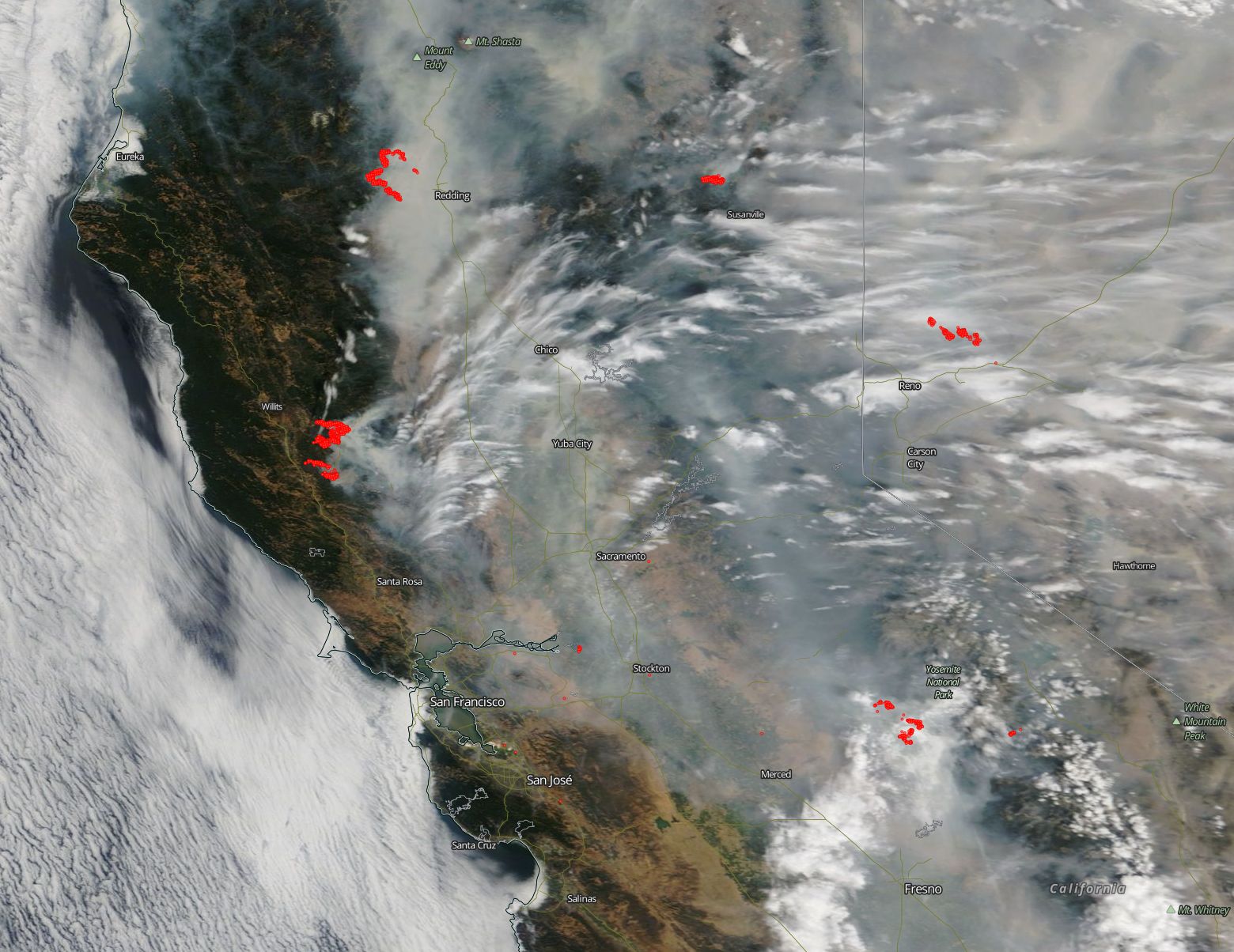
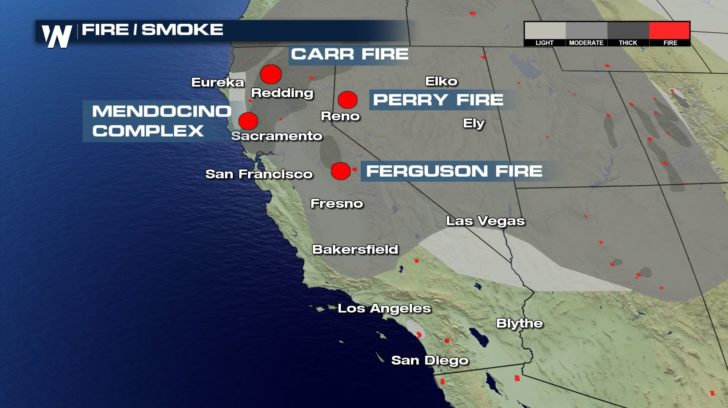
More than a dozen wildfires are burning in the state of California, with several of them threatening life and property. NASA's EOSDIS provides the capability to interactively browse over 600 global, full-resolution satellite imagery layers and then download the underlying data. Many of the available imagery layers are updated within three hours of observation, essentially showing the entire Earth as it looks "right now". The natural-color satellite image below was collected by the Aqua satellite on July 30, 2018. Actively burning areas, detected by thermal bands, are outlined in red.
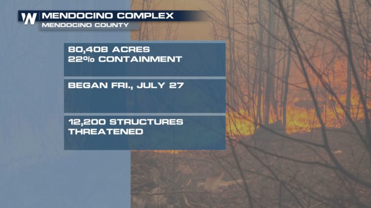
 The Mendocino Complex of fires are made up of the River and Ranch fires. The River fire grew almost 7,000 acres overnight to 27,069 acres. One more residence and two more outbuildings were destroyed, but 12,200 structures are still being threatened by this fire. As with most of the fires wreaking havoc in California, this one is being helped along by weather conditions as hot, dry, windy conditions continue to persist. The fire burned actively throughout the night and firefighters were challenged by long distance spotting. The Ranch fire (the second part of the Mendocino Complex of fires) grew by more than 12,000 acres to 35,076 acres. Seven residences and 3 outbuildings have been destroyed to date by this fire. As with the River fire, weather conditions in the area are not conducive to firefighting but are to fire spread. There does not seem to be any end in sight for either of these fires.
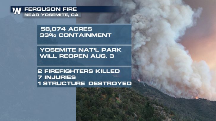
 The Ferguson fire started on July 13 in the Sierra National Forest west of Yosemite National Park. The fire is the slowest growing of the fires represented here having only grown 1,187 acres overnight. This fire is listed as 33% contained. The residents of the area have been cautioned that the smoke may increase due to firefighting efforts which will include "Tactical Firing" which Inciweb describes as "an effective way to reduce fuel loads while simultaneously widening or extending containment lines. It can reduce the duration and intensity of wildfires, particularly by decreasing available fuels and weakening the fire as it approaches containment lines." So basically firefighters set fires and burn the fuels in a controlled manner ahead of the actual fire in an effort to contain fire growth. Much of the forest in this area suffered extreme stress due to the extended drought of 2012 through 2017, and bark beetle damage, leaving many dead trees through which the fire has burned rapidly. Many surrounding towns have been under evacuation orders, and many popular areas of the national park were closed on July 25.
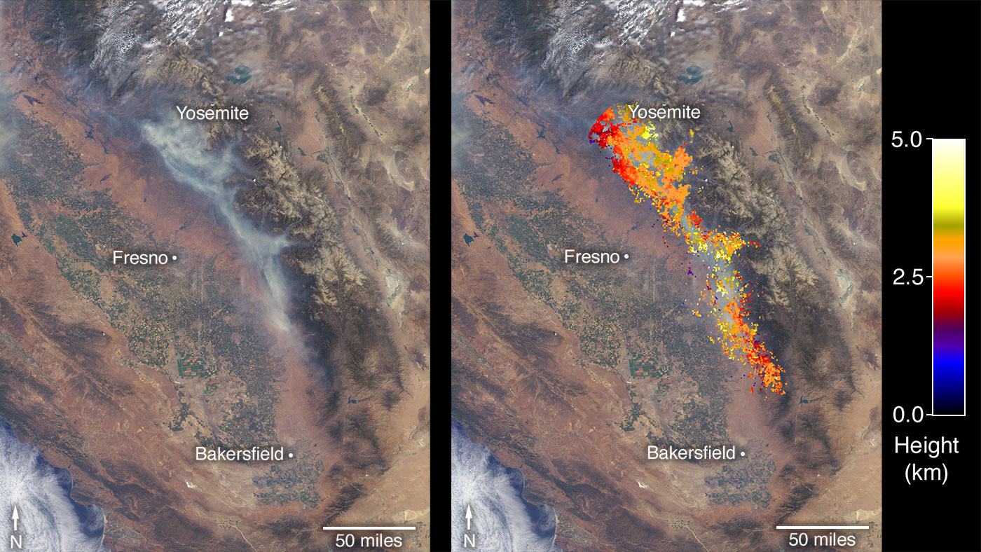 [This image shows the Ferguson Fire near Yosemite National Park on July 29 as observed by NASA’s MISR instrument. The angular information from MISR’s images is used to calculate the height of the smoke plume. The results are superimposed on the image on the right. Credits: NASA/GSFC/LaRC/JPL-Caltech, MISR Team]
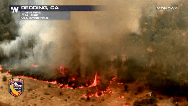
On July 23, another fire ignited northwest of Whiskeytown Lake, a reservoir in northern California. Dubbed the Carr Fire, it remained relatively small through July 25, but advanced rapidly toward the city of Redding the following day, prompting mass evacuations. From last night until today the Carr fire has consumed 12,000 more acres for a total of 110,154 acres and is 27% contained. The number of residences destroyed overnight rose by 161, commercial buildings by 1, and outbuildings by 108. These numbers do not even reflect structures damaged by the fire, only those destroyed. This fire has proven to be extremely difficult to contain due to both weather conditions and terrain conditions. CAL fire notes that: "Converging East and West winds paired with steep terrain have challenged firefighting efforts." There are still over 2,500 structures being threatened by this fire and the weather conditions that contributed to the start of the this fire have yet to abate.
[This image shows the Ferguson Fire near Yosemite National Park on July 29 as observed by NASA’s MISR instrument. The angular information from MISR’s images is used to calculate the height of the smoke plume. The results are superimposed on the image on the right. Credits: NASA/GSFC/LaRC/JPL-Caltech, MISR Team]
On July 23, another fire ignited northwest of Whiskeytown Lake, a reservoir in northern California. Dubbed the Carr Fire, it remained relatively small through July 25, but advanced rapidly toward the city of Redding the following day, prompting mass evacuations. From last night until today the Carr fire has consumed 12,000 more acres for a total of 110,154 acres and is 27% contained. The number of residences destroyed overnight rose by 161, commercial buildings by 1, and outbuildings by 108. These numbers do not even reflect structures damaged by the fire, only those destroyed. This fire has proven to be extremely difficult to contain due to both weather conditions and terrain conditions. CAL fire notes that: "Converging East and West winds paired with steep terrain have challenged firefighting efforts." There are still over 2,500 structures being threatened by this fire and the weather conditions that contributed to the start of the this fire have yet to abate.
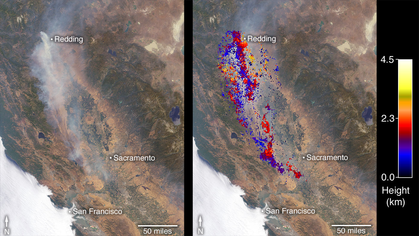 [This image shows the Carr Fire near Redding California on July 27 as observed by NASA’s MISR instrument. The angular information from MISR’s images is used to calculate the height of the smoke plume. The results are superimposed on the image on the right. Credits: NASA/GSFC/LaRC/JPL-Caltech, MISR Team]
All of these fires are causing huge amounts of destruction, but they are also creating health hazards with the amount of smoke that is being pumped into the atmosphere. A study from Georgia Tech found that particle pollution from wildfires, long known for containing soot and other fine particles known to be dangerous to human health, is much worse than previously thought. Naturally burning timber and brush from wildfires release dangerous particles into the air at a rate three times as high as levels known by the EPA, researchers at Georgia Tech found. The study also found wildfires spew methanol, benzene, ozone and other noxious chemicals.
[This image shows the Carr Fire near Redding California on July 27 as observed by NASA’s MISR instrument. The angular information from MISR’s images is used to calculate the height of the smoke plume. The results are superimposed on the image on the right. Credits: NASA/GSFC/LaRC/JPL-Caltech, MISR Team]
All of these fires are causing huge amounts of destruction, but they are also creating health hazards with the amount of smoke that is being pumped into the atmosphere. A study from Georgia Tech found that particle pollution from wildfires, long known for containing soot and other fine particles known to be dangerous to human health, is much worse than previously thought. Naturally burning timber and brush from wildfires release dangerous particles into the air at a rate three times as high as levels known by the EPA, researchers at Georgia Tech found. The study also found wildfires spew methanol, benzene, ozone and other noxious chemicals.
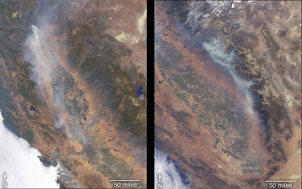
 The Multi-angle Imaging SpectroRadiometer (MISR) instrument on NASA’s Terra satellite passed over California on July 27 and July 29, observing the Carr Fire (below, left image) on July 27 and the Ferguson Fire (below, right image) on July 29. The MISR instrument has nine cameras that view Earth at different angles.
 Information from NASA JPL
Edited for WeatherNation by Meteorologist Mace Michaels
Information from NASA JPL
Edited for WeatherNation by Meteorologist Mace Michaels
The Mendocino Complex of fires are made up of the River and Ranch fires. The River fire grew almost 7,000 acres overnight to 27,069 acres. One more residence and two more outbuildings were destroyed, but 12,200 structures are still being threatened by this fire. As with most of the fires wreaking havoc in California, this one is being helped along by weather conditions as hot, dry, windy conditions continue to persist. The fire burned actively throughout the night and firefighters were challenged by long distance spotting. The Ranch fire (the second part of the Mendocino Complex of fires) grew by more than 12,000 acres to 35,076 acres. Seven residences and 3 outbuildings have been destroyed to date by this fire. As with the River fire, weather conditions in the area are not conducive to firefighting but are to fire spread. There does not seem to be any end in sight for either of these fires.
The Ferguson fire started on July 13 in the Sierra National Forest west of Yosemite National Park. The fire is the slowest growing of the fires represented here having only grown 1,187 acres overnight. This fire is listed as 33% contained. The residents of the area have been cautioned that the smoke may increase due to firefighting efforts which will include "Tactical Firing" which Inciweb describes as "an effective way to reduce fuel loads while simultaneously widening or extending containment lines. It can reduce the duration and intensity of wildfires, particularly by decreasing available fuels and weakening the fire as it approaches containment lines." So basically firefighters set fires and burn the fuels in a controlled manner ahead of the actual fire in an effort to contain fire growth. Much of the forest in this area suffered extreme stress due to the extended drought of 2012 through 2017, and bark beetle damage, leaving many dead trees through which the fire has burned rapidly. Many surrounding towns have been under evacuation orders, and many popular areas of the national park were closed on July 25.
[This image shows the Ferguson Fire near Yosemite National Park on July 29 as observed by NASA’s MISR instrument. The angular information from MISR’s images is used to calculate the height of the smoke plume. The results are superimposed on the image on the right. Credits: NASA/GSFC/LaRC/JPL-Caltech, MISR Team]
On July 23, another fire ignited northwest of Whiskeytown Lake, a reservoir in northern California. Dubbed the Carr Fire, it remained relatively small through July 25, but advanced rapidly toward the city of Redding the following day, prompting mass evacuations. From last night until today the Carr fire has consumed 12,000 more acres for a total of 110,154 acres and is 27% contained. The number of residences destroyed overnight rose by 161, commercial buildings by 1, and outbuildings by 108. These numbers do not even reflect structures damaged by the fire, only those destroyed. This fire has proven to be extremely difficult to contain due to both weather conditions and terrain conditions. CAL fire notes that: "Converging East and West winds paired with steep terrain have challenged firefighting efforts." There are still over 2,500 structures being threatened by this fire and the weather conditions that contributed to the start of the this fire have yet to abate.
[This image shows the Carr Fire near Redding California on July 27 as observed by NASA’s MISR instrument. The angular information from MISR’s images is used to calculate the height of the smoke plume. The results are superimposed on the image on the right. Credits: NASA/GSFC/LaRC/JPL-Caltech, MISR Team]
All of these fires are causing huge amounts of destruction, but they are also creating health hazards with the amount of smoke that is being pumped into the atmosphere. A study from Georgia Tech found that particle pollution from wildfires, long known for containing soot and other fine particles known to be dangerous to human health, is much worse than previously thought. Naturally burning timber and brush from wildfires release dangerous particles into the air at a rate three times as high as levels known by the EPA, researchers at Georgia Tech found. The study also found wildfires spew methanol, benzene, ozone and other noxious chemicals.
The Multi-angle Imaging SpectroRadiometer (MISR) instrument on NASA’s Terra satellite passed over California on July 27 and July 29, observing the Carr Fire (below, left image) on July 27 and the Ferguson Fire (below, right image) on July 29. The MISR instrument has nine cameras that view Earth at different angles.
Information from NASA JPL
Edited for WeatherNation by Meteorologist Mace MichaelsAll Weather News
More
Hurricane Center Monitoring Florida for Tropical Development
Residents and visitors to the Southeast will
30 Jun 2025 10:00 PM

Barry Makes Landfall, Watching Flossie Next
While the Eastern Pacific has made most of th
30 Jun 2025 9:40 PM

Severe Storms For the East Coast Through Tuesday
Frontal systems have been crossing the northe
30 Jun 2025 9:00 PM

Severe Weather Threat Continues in the Midwest
It has been an active, severe season across t
30 Jun 2025 9:00 PM


Where Rain Could Dampen Holiday Travel Plans
AAA is expecting over 70 million travelers to
30 Jun 2025 3:00 PM

Thunderstorms Possible in the Southeast Overnight
SOUTHEAST - Strong thunderstorms have develop
28 Jun 2025 2:40 AM