Recent Tornado Scars Seen By Satellite
Special Stories
16 Apr 2020 11:40 AM
Original story by Kathryn Hansen
NASA Earth Observatory images by Joshua Stevens
The tornado damage from this past weekend's severe weather outbreak can be clearly seen from ground level. However thousands of miles above Earth, via satellite, the visible scars can be seen across many landscapes. This imagery is from NASA's Aqua Satellite using the Moderate Resolution Imaging Spectroradiometer (MODIS).
 Courtesy NASA's Aqua Satellite using MODIS
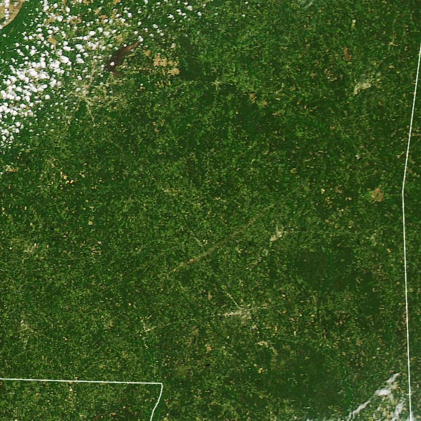
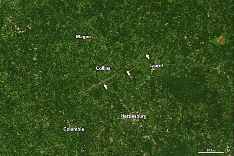
Notice how you can see the path of this tornado in Mississippi. This was the EF-4 that was as wide as 2 miles at its widest extent, traveling on the ground for more than 65 miles. The imagery, courtesy the Earth Laboratory of NASA, shows a brown stripe where the tornado's path ripped the green vegetation away.
Courtesy NASA's Aqua Satellite using MODIS
Notice how you can see the path of this tornado in Mississippi. This was the EF-4 that was as wide as 2 miles at its widest extent, traveling on the ground for more than 65 miles. The imagery, courtesy the Earth Laboratory of NASA, shows a brown stripe where the tornado's path ripped the green vegetation away.
 NASA's Aqua Satellite via MODIS
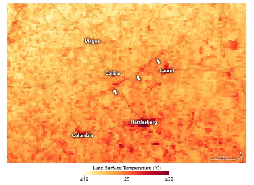
Take for instance the same image, but in infrared mode. This is a remote sensing tool allowing us to examine the radiant heat of objects. In this case, the untouched ground away from the tornado is a brighter orange, representing slightly cooler reflective temperature. On the other hand where the tornado struck, that line appears darker orange and correlates to warmer reflective temperature.
Why would it be hotter in the tornado damage path?
Look to the leaves. Since this tornado was so wide and so strong, it ripped the leaves off vegetation and killed many trees. As a result, those trees and surrounding vegetation are not cooling the air by "transpiration" which is basically evaporation from the leaves, into the air, which usually cools the air slightly.
Related Story: Sunday Tornado Possibly Mississippi's Widest On Record
Another case example of the recent severe weather outbreak takes us to South Carolina. Here, EF-3 tornado damage was observed by the European Space Agency's Sentinel-2 Satellite.
This tornado in South Carolina can be more clearly seen when you look at the landscape before the severe weather event.
https://twitter.com/NWSColumbia/status/1250531671180525568
The EF-3 that hit South Carolina Monday was rare. A tornado of that strength and rating does not happen often in the state, according to Meteorologist Melissa Griffin.
https://twitter.com/mlgriffinWX1/status/1250479828039540738
Additional severe weather is expected to occur this weekend, especially on Sunday the 19th of April.
Related Story: Enhanced Severe Risk Returns This Weekend
NASA's Aqua Satellite via MODIS
Take for instance the same image, but in infrared mode. This is a remote sensing tool allowing us to examine the radiant heat of objects. In this case, the untouched ground away from the tornado is a brighter orange, representing slightly cooler reflective temperature. On the other hand where the tornado struck, that line appears darker orange and correlates to warmer reflective temperature.
Why would it be hotter in the tornado damage path?
Look to the leaves. Since this tornado was so wide and so strong, it ripped the leaves off vegetation and killed many trees. As a result, those trees and surrounding vegetation are not cooling the air by "transpiration" which is basically evaporation from the leaves, into the air, which usually cools the air slightly.
Related Story: Sunday Tornado Possibly Mississippi's Widest On Record
Another case example of the recent severe weather outbreak takes us to South Carolina. Here, EF-3 tornado damage was observed by the European Space Agency's Sentinel-2 Satellite.
This tornado in South Carolina can be more clearly seen when you look at the landscape before the severe weather event.
https://twitter.com/NWSColumbia/status/1250531671180525568
The EF-3 that hit South Carolina Monday was rare. A tornado of that strength and rating does not happen often in the state, according to Meteorologist Melissa Griffin.
https://twitter.com/mlgriffinWX1/status/1250479828039540738
Additional severe weather is expected to occur this weekend, especially on Sunday the 19th of April.
Related Story: Enhanced Severe Risk Returns This Weekend
Courtesy NASA's Aqua Satellite using MODIS
Notice how you can see the path of this tornado in Mississippi. This was the EF-4 that was as wide as 2 miles at its widest extent, traveling on the ground for more than 65 miles. The imagery, courtesy the Earth Laboratory of NASA, shows a brown stripe where the tornado's path ripped the green vegetation away.
NASA's Aqua Satellite via MODIS
Take for instance the same image, but in infrared mode. This is a remote sensing tool allowing us to examine the radiant heat of objects. In this case, the untouched ground away from the tornado is a brighter orange, representing slightly cooler reflective temperature. On the other hand where the tornado struck, that line appears darker orange and correlates to warmer reflective temperature.
Why would it be hotter in the tornado damage path?
Look to the leaves. Since this tornado was so wide and so strong, it ripped the leaves off vegetation and killed many trees. As a result, those trees and surrounding vegetation are not cooling the air by "transpiration" which is basically evaporation from the leaves, into the air, which usually cools the air slightly.
Related Story: Sunday Tornado Possibly Mississippi's Widest On Record
Another case example of the recent severe weather outbreak takes us to South Carolina. Here, EF-3 tornado damage was observed by the European Space Agency's Sentinel-2 Satellite.
This tornado in South Carolina can be more clearly seen when you look at the landscape before the severe weather event.
https://twitter.com/NWSColumbia/status/1250531671180525568
The EF-3 that hit South Carolina Monday was rare. A tornado of that strength and rating does not happen often in the state, according to Meteorologist Melissa Griffin.
https://twitter.com/mlgriffinWX1/status/1250479828039540738
Additional severe weather is expected to occur this weekend, especially on Sunday the 19th of April.
Related Story: Enhanced Severe Risk Returns This Weekend
All Weather News
More


More Storms for the East Sunday and Monday
A low-pressure system crashing through the Mi
2 Aug 2026 2:20 AM

After Reaching Category 5, Genevieve Weakens in the Pacific
PacificGenevieve formed on last Friday south
2 Aug 2026 1:30 AM

Flooding, Severe Storms Target the Midwest Again
After an active week of storms across the nor
1 Aug 2026 1:40 AM

Flooding Risk Increases as Heavy Rain Targets the Tri-State Area
Tuesday, heavy rainfall moved across the Nort
30 Jul 2026 12:25 AM

Severe Weather: Energy From the Midwest Now in the Southeast
UPPER MIDWEST - Through Monday, dangerous tor
29 Jul 2026 10:30 PM