Regional Climate Centers: Hubs of Local Expertise
Special Stories
7 Nov 2018 12:32 PM
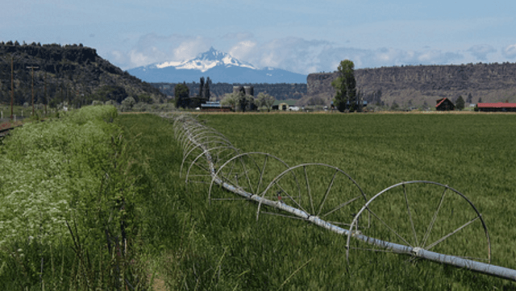
[Green hayfield in Oregon. From NOAA]
[NOAA] If you are looking for climate date from your area, or a more in-depth analysis in a local area or region, the Regional Climate Centers are a great source for information. Across the United States, six regional climate centers support the work of NOAA and the National Centers for for Environmental Information (NCEI). The Regional Climate Centers (RCCs) add local expertise and perspective to the study and monitoring of our climate and weather and their impacts. The work of the RCCs assists numerous business sectors, like manufacturing, farming, and livestock, and specific groups, such as policymakers, city planners, the media, and constituent groups.
The work of the RCCs supports the activities of NCEI. The centers answer regional climate questions and document data requests from their local constituents, as well as prepare or consult on reports, assessments, and outlooks that help decision makers. RCCs also apply regional climate and weather data to develop programs and services that address issues in their regions. RCCs work directly with NCEI, which manages the RCC program. NCEI provides regional climate services to the public with the RCCs and in cooperation with several Regional Climate Services Directors, who spearhead regional information sharing and joint projects.
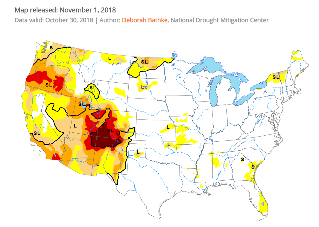 [Drought Monitor from National Drought Mitigation Center]
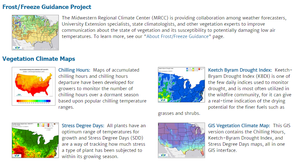 [Products available from the Vegetation Impact Program (VIP). From MRCC]
Midwest: The Vegetation Impact Program (VIP) is an initiative led by the MRCC to bring together real-time climate monitoring, forecasters, and citizen science participation for understanding the current susceptibility and climate-related impacts on vegetation. Products include frost/freeze monitoring tools as well as stress degree-days that monitor heat stress to corn and chilling hours that impact dormant season recovery of small fruits.
Northeast: Developed by the NRCC, SC Applied Climate Information System (scACIS) allows climate service providers, like state climatologists, to access a wide range of daily and monthly climate data products. Products include tabular and graphical data summaries as well as a number of map-based products using both station and gridded data values.
Southeast: SERCC features the Climate Perspectives tool to compare current weather conditions and forecasts with the long-term weather records from stations across the Southeast. Climate Perspectives provides a climatological synopsis of recent temperature and precipitation patterns at a user-selected weather station. The daily updated climatological information allows the user to readily assess the extremeness of an ongoing weather event—such as exceptionally hot, cold, or wet conditions—over days, weeks, or months and compare them with the historical record.
[Products available from the Vegetation Impact Program (VIP). From MRCC]
Midwest: The Vegetation Impact Program (VIP) is an initiative led by the MRCC to bring together real-time climate monitoring, forecasters, and citizen science participation for understanding the current susceptibility and climate-related impacts on vegetation. Products include frost/freeze monitoring tools as well as stress degree-days that monitor heat stress to corn and chilling hours that impact dormant season recovery of small fruits.
Northeast: Developed by the NRCC, SC Applied Climate Information System (scACIS) allows climate service providers, like state climatologists, to access a wide range of daily and monthly climate data products. Products include tabular and graphical data summaries as well as a number of map-based products using both station and gridded data values.
Southeast: SERCC features the Climate Perspectives tool to compare current weather conditions and forecasts with the long-term weather records from stations across the Southeast. Climate Perspectives provides a climatological synopsis of recent temperature and precipitation patterns at a user-selected weather station. The daily updated climatological information allows the user to readily assess the extremeness of an ongoing weather event—such as exceptionally hot, cold, or wet conditions—over days, weeks, or months and compare them with the historical record.
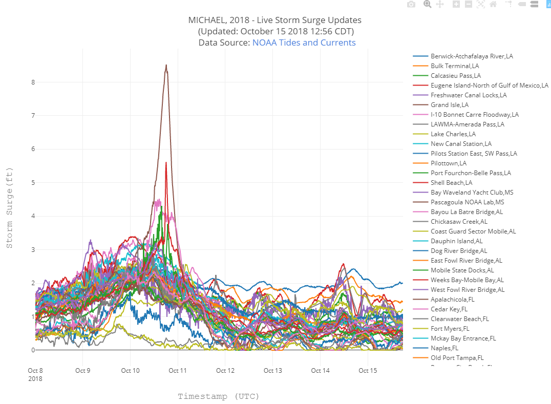 [Storm surge updated during Hurricane Michael from SRCC SURGEDAT]
Southern: SRCC participates in SCIPP, the Southern Climate Impacts Planning Program, to focus on climate hazards and research to improve the region’s resiliency. SRCC acts as the operational arm for several data tools, including SURGEDAT, the world’s most comprehensive storm surge database.
Western: WRCC is the national archive for the Remote Automated Weather Station (RAWS) network in support of wildland fire management agencies. RAWS is a wildland fire interagency network of about 2,000 U.S. stations that provide hourly fire weather information. The network began with a few stations in the 1980s and has been expanding since. In the West, these stations provide a unique opportunity to monitor weather and climate for mid- and high-elevation ranges. These data support wildland fire operations including roadside fire danger signs and information support for National Weather Service Incident Meteorologists.
[Storm surge updated during Hurricane Michael from SRCC SURGEDAT]
Southern: SRCC participates in SCIPP, the Southern Climate Impacts Planning Program, to focus on climate hazards and research to improve the region’s resiliency. SRCC acts as the operational arm for several data tools, including SURGEDAT, the world’s most comprehensive storm surge database.
Western: WRCC is the national archive for the Remote Automated Weather Station (RAWS) network in support of wildland fire management agencies. RAWS is a wildland fire interagency network of about 2,000 U.S. stations that provide hourly fire weather information. The network began with a few stations in the 1980s and has been expanding since. In the West, these stations provide a unique opportunity to monitor weather and climate for mid- and high-elevation ranges. These data support wildland fire operations including roadside fire danger signs and information support for National Weather Service Incident Meteorologists.
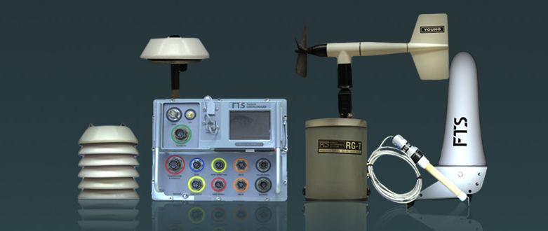 [Equipment used in a Remote Automatic Weather Stations (RAWS). From NOAA]
Edited for WeatherNation by Meteorologist Mace Michaels
[Equipment used in a Remote Automatic Weather Stations (RAWS). From NOAA]
Edited for WeatherNation by Meteorologist Mace Michaels
RCCs also collaborate with the National Weather Service, the American Association of State Climatologists, and other organizations to collectively deliver and improve climate services at the national, regional, and state level. The knowledge and perspective of RCC offices add relevance to NOAA’s climate services.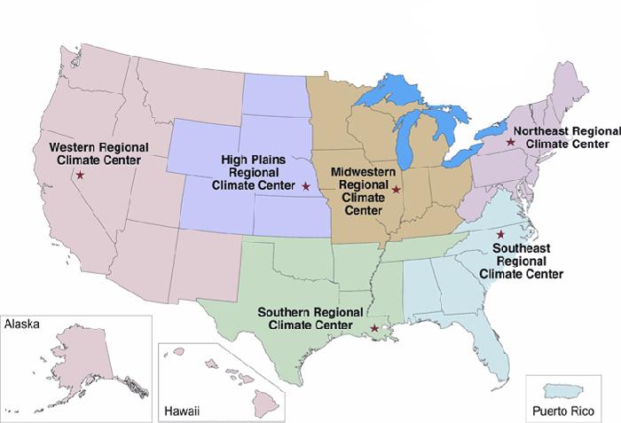
- Western Regional Climate Center (WRCC) based in Reno, Nevada
- High Plains Regional Climate Center (HPRCC) based in Lincoln, Nebraska
- Southern Regional Climate Center (SRCC) based in Baton Rouge, Louisiana
- Midwestern Regional Climate Center (MRCC) based in Champaign, Illinois
- Southeast Regional Climate Center (SERCC) based in Chapel Hill, North Carolina
- Northeast Regional Climate Center (NRCC) based in Ithaca, New York
- Regional climate outlooks, reports, and assessments:
- Monthly for State of the Climate reports
- Regularly for the U.S. Drought Monitor
- Quarterly for Drought.gov
- As needed for the Drought Early Warning System (DEWS)
- Participation in the State and National Climate Extremes committees
- Programming for the Long-term Station Extremes for America (ThreadEx) program
- Regional programs, services, and applied science, such as specialized datasets and education, geared toward concerns and needs in their service areas
[Drought Monitor from National Drought Mitigation Center]
RCCs: Meeting Many Climate Needs
Each RCC region has its own personality, figuratively speaking. RCCs, being the embedded point of contact, have the opportunity to address regional issues with an eye toward local needs and characteristics. Each region encompasses a unique set of climate conditions, which vary within the region. Many groups look to RCCs for help to understand climate conditions that may be affecting their lands or livelihoods. The centers tailor their work to meet specific challenges and then develop projects, outreach plans, information-sharing ideas, and problem-solving tactics. RCCs use their own data and NCEI collections to create tools to understand climate and its impacts. This includes providing context to extreme climate events, knowledge about relationships between atmospheric circulation patterns and regional climate, and response strategies for events, such as hurricanes and drought.Projects by RCCs
Each region undertakes different types of programs and projects for its constituents. For example: High Plains: HPRCC produces climate summary maps on a daily basis to give stakeholders perspective on the current and past climate conditions. These are invaluable to a wide variety of customers to assess the state of the climate. In particular, these maps help inform decisions on issues such as drought early warning, water management, and energy usage. This long-standing and popular product draws upon the Applied Climate Information System (ACIS) framework, a system developed by the RCC program. Users are able to choose from precipitation, temperature, heating and cooling degree days, and a standardized precipitation index over various time intervals and spatial scales.
[Products available from the Vegetation Impact Program (VIP). From MRCC]
Midwest: The Vegetation Impact Program (VIP) is an initiative led by the MRCC to bring together real-time climate monitoring, forecasters, and citizen science participation for understanding the current susceptibility and climate-related impacts on vegetation. Products include frost/freeze monitoring tools as well as stress degree-days that monitor heat stress to corn and chilling hours that impact dormant season recovery of small fruits.
Northeast: Developed by the NRCC, SC Applied Climate Information System (scACIS) allows climate service providers, like state climatologists, to access a wide range of daily and monthly climate data products. Products include tabular and graphical data summaries as well as a number of map-based products using both station and gridded data values.
Southeast: SERCC features the Climate Perspectives tool to compare current weather conditions and forecasts with the long-term weather records from stations across the Southeast. Climate Perspectives provides a climatological synopsis of recent temperature and precipitation patterns at a user-selected weather station. The daily updated climatological information allows the user to readily assess the extremeness of an ongoing weather event—such as exceptionally hot, cold, or wet conditions—over days, weeks, or months and compare them with the historical record.
[Storm surge updated during Hurricane Michael from SRCC SURGEDAT]
Southern: SRCC participates in SCIPP, the Southern Climate Impacts Planning Program, to focus on climate hazards and research to improve the region’s resiliency. SRCC acts as the operational arm for several data tools, including SURGEDAT, the world’s most comprehensive storm surge database.
Western: WRCC is the national archive for the Remote Automated Weather Station (RAWS) network in support of wildland fire management agencies. RAWS is a wildland fire interagency network of about 2,000 U.S. stations that provide hourly fire weather information. The network began with a few stations in the 1980s and has been expanding since. In the West, these stations provide a unique opportunity to monitor weather and climate for mid- and high-elevation ranges. These data support wildland fire operations including roadside fire danger signs and information support for National Weather Service Incident Meteorologists.
[Equipment used in a Remote Automatic Weather Stations (RAWS). From NOAA]
Edited for WeatherNation by Meteorologist Mace MichaelsAll Weather News
More
Severe Storms For the East Coast Through Tuesday
A cold front moving through a moist airmass h
2 Jul 2025 1:00 AM


Western Heat Continues With Some Relief
A large dome of hot high pressure remains acr
1 Jul 2025 11:00 PM

NHC Monitoring Front in the Southeast Ahead of 4th of July
SOUTHEAST - A frontal boundary moving through
1 Jul 2025 10:35 PM

Where Rain Could Dampen Holiday Travel Plans
AAA is expecting over 70 million travelers to
1 Jul 2025 4:35 PM

Severe Weather Threat Continues in the Midwest
It has been an active, severe season across t
30 Jun 2025 9:00 PM