Robots To Aid in Hurricane Forecasts
Special Stories
31 Jul 2019 12:05 PM
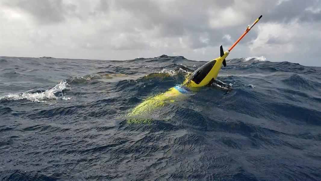
Since 2014, there's been something deep in the ocean and Gulf of Mexico waters keeping an eye on conditions during hurricane season: robot ocean gliders.
Scientists at NOAA have been sending out these ocean gliders to gather information that will hopefully assist scientists when it comes to improving the accuracy of hurricane forecast models.
https://youtu.be/uCv_yUvm5yU
Scientists are now experimenting with using gliders to locate populations of spawning fish. The glider illustrated here is outfitted with an acoustic receiver to “listen” for vocalizations—grunting sounds—made by some fish as they mass together to spawn in the U.S. Caribbean. The vehicle records the geolocation of the sounds that it “hears” onto an onboard memory card. VIDEO CREDIT - NOAA Ocean Services
Each of these unmanned gliders have sensors on board that take measurements of both water temperature and salt content at different ocean levels. These two different ocean conditions play a huge role in letting scientists know how strong a hurricane might become.
“If the surface of the ocean is much warmer and much less salty than the deeper layers, it will form a cap that prevents the mixing and upwelling of cool water from below,” said Gustavo Goni, an oceanographer at NOAA’s Atlantic Oceanographic and Meteorological Laboratory who is helping lead this year's glider operations.
 Orange lines show the proposed paths for gliders to travel this summer, where they will record temperature and salinity data from the surface to a half mile below. Once launched, the glider will make regular dives along a set course, surfacing several times a day to send its data to an available satellite. Warm water has the potential to strengthen storms while cool waters may weaken them, so knowing if a storm will pass over only warm water or areas where cold water may be stirred up from below helps scientists and forecasters predict whether a storm will intensify or weaken as it travels. Credit: NOAA
FIND OUT WHERE OCEANS GLIDERS ARE CURRENTLY MAKING OBSERVATIONS
Whether it's quiet, or during a tropical storm or hurricane, these robots are able to collect data as far down as a half mile below the surface and then send the information to satellites when they come back up.
WATCH A PREVIOUS MISSION NOW!
https://www.youtube.com/watch?v=PrgixryvYNo&feature=youtu.be
All of the data that is collected by these ocean gliders will play a huge role in hurricane model accuracy, giving clues to where we still might need more work to be done but also, where our models have been most accurate with predictions.
“Representing the ocean accurately in forecast models is critical,” said LCDR Benjamin LaCour, glider program manager for NOAA's Integrated Ocean Observing System. “The gliders help us do that because they’re giving us high-volume, information-rich data in areas that are challenging for the models to get right.”
LEARN MORE ABOUT OCEAN GLIDERS
The scientists at NOAA have been working with other partners to study ocean conditions during hurricane season in areas that typically see storms including the U.S. Navy, Rutgers University, University of Miami, and University of Puerto Rico-Mayaguez.
We had a chance to talk with Dr. Gustavo Goni to learn a little more about this program, here's a excerpt from his interview.
https://youtu.be/13D1JPdAgLI
For WeatherNation, I'm Meteorologist Meredith Garofalo
Orange lines show the proposed paths for gliders to travel this summer, where they will record temperature and salinity data from the surface to a half mile below. Once launched, the glider will make regular dives along a set course, surfacing several times a day to send its data to an available satellite. Warm water has the potential to strengthen storms while cool waters may weaken them, so knowing if a storm will pass over only warm water or areas where cold water may be stirred up from below helps scientists and forecasters predict whether a storm will intensify or weaken as it travels. Credit: NOAA
FIND OUT WHERE OCEANS GLIDERS ARE CURRENTLY MAKING OBSERVATIONS
Whether it's quiet, or during a tropical storm or hurricane, these robots are able to collect data as far down as a half mile below the surface and then send the information to satellites when they come back up.
WATCH A PREVIOUS MISSION NOW!
https://www.youtube.com/watch?v=PrgixryvYNo&feature=youtu.be
All of the data that is collected by these ocean gliders will play a huge role in hurricane model accuracy, giving clues to where we still might need more work to be done but also, where our models have been most accurate with predictions.
“Representing the ocean accurately in forecast models is critical,” said LCDR Benjamin LaCour, glider program manager for NOAA's Integrated Ocean Observing System. “The gliders help us do that because they’re giving us high-volume, information-rich data in areas that are challenging for the models to get right.”
LEARN MORE ABOUT OCEAN GLIDERS
The scientists at NOAA have been working with other partners to study ocean conditions during hurricane season in areas that typically see storms including the U.S. Navy, Rutgers University, University of Miami, and University of Puerto Rico-Mayaguez.
We had a chance to talk with Dr. Gustavo Goni to learn a little more about this program, here's a excerpt from his interview.
https://youtu.be/13D1JPdAgLI
For WeatherNation, I'm Meteorologist Meredith Garofalo
All Weather News
More
Wildfire Outbreak in the Pacific Northwest
SPOKANE, WA - On Saturday, August 1st, the Ol
3 Aug 2026 1:55 AM

More Storms for the East Through Monday
A low-pressure system that moved through the
3 Aug 2026 1:50 AM


After Reaching Category 5, Genevieve Weakens in the Pacific
PacificGenevieve formed last Friday south of
3 Aug 2026 12:30 AM

Flooding, Severe Storms Target the Midwest Again
After an active week of storms across the nor
1 Aug 2026 1:40 AM

Flooding Risk Increases as Heavy Rain Targets the Tri-State Area
Tuesday, heavy rainfall moved across the Nort
30 Jul 2026 12:25 AM

Severe Weather: Energy From the Midwest Now in the Southeast
UPPER MIDWEST - Through Monday, dangerous tor
29 Jul 2026 10:30 PM