Satellite Animation View of the Cold Air Outbreak
Special Stories
1 Feb 2019 7:33 AM
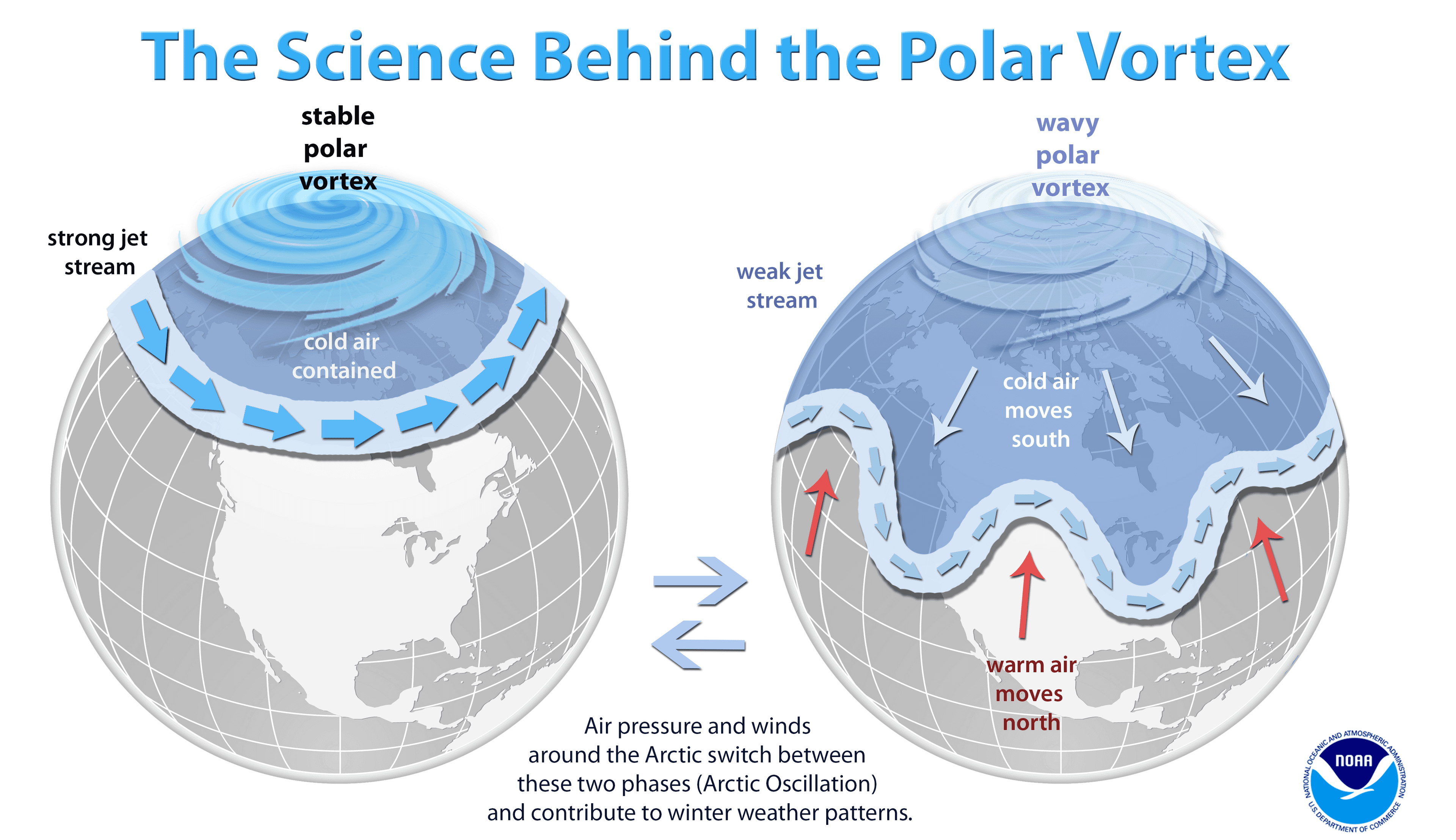
[NASA] The northern U.S. has been gripped by the lowest temperatures it has seen in years. An unusually cold Arctic air mass, centered around a piece of the polar vortex, is responsible for the severe temperatures. In many areas, readings plunged well below 0 degrees Fahrenheit (-18 degrees Celsius).
NASA's Atmospheric Infrared Sounder (AIRS) instrument aboard the Aqua satellite captured the polar vortex as it moved southward from central Canada into the U.S. Midwest from Jan. 20 through Jan. 29. The lowest temperatures are shown in purple and blue and range from -40 degrees Fahrenheit (also -40 degrees Celsius) to -10 degrees Fahrenheit (-23 degrees Celsius). As the data series progresses, you can see how the coldest purple areas of the air mass scoop down into the U.S. The cold outbreak is responsible for a number of deaths, disruptions to services, and energy outages in the affected areas.
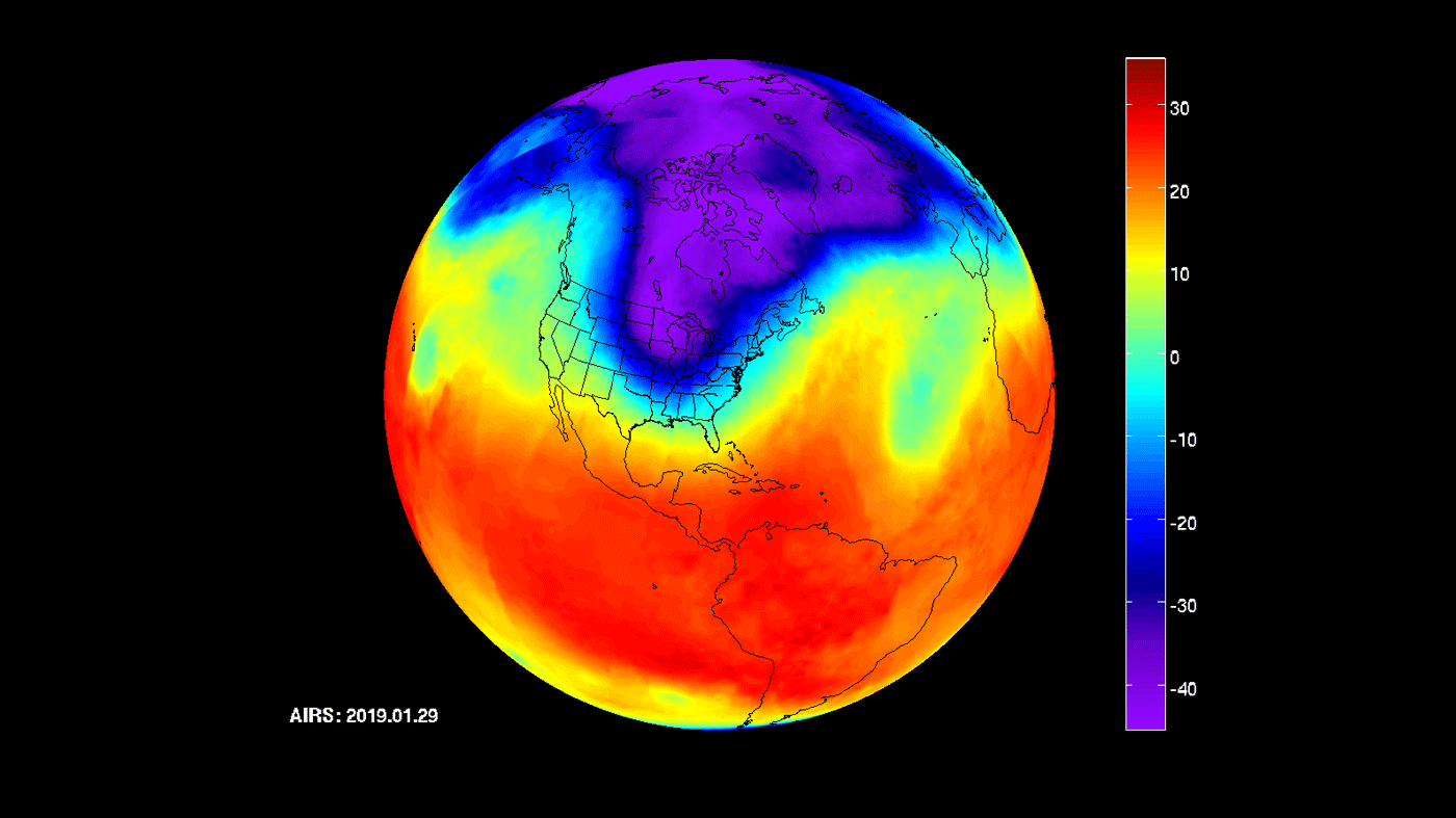 [NASA's Atmospheric Infrared Sounder (AIRS) instrument captures a polar vortex moving from Central Canada into the U.S. Midwest from January 20 through January 29. Credits: NASA/JPL-Caltech AIRS Project]
AIRS, in conjunction with the Advanced Microwave Sounding Unit (AMSU), senses emitted infrared and microwave radiation from Earth to provide a three-dimensional look at Earth's weather and climate. Working in tandem, the two instruments make simultaneous observations down to Earth's surface. With more than 2,000 channels sensing different regions of the atmosphere, the system creates a global, three-dimensional map of atmospheric temperature and humidity, cloud amounts and heights, greenhouse gas concentrations and many other atmospheric phenomena.
A similar 2014 looking movie below from AIRS shows a cold outbreak plunging southward from Canada. The temperatures shown are at a pressure of 850 hectopascals (hPa or millibars; sea level pressure is normally around 1000 hPa). Pressures of 850 hPa correspond roughly to an altitude of about 3,000 feet above sea level. The temperatures in the movie range from about minus 18 degrees Fahrenheit to warmer than 66 degrees Fahrenheit.
https://www.youtube.com/watch?time_continue=6&v=G600mcjVmjI
The very coldest temperatures in purples and blues are minus 18 to 17 degrees Fahrenheit. The most obvious feature of the movie is the tongue of cold air moving out of Canada and southward to cover much of the eastern United States during early January 2014. This event was covered extensively in the media, and introduced the term 'polar vortex' to a broader audience. This global perspective illustrates some features not noted in all the recent media attention. Perhaps most obvious: this is not a global phenomenon. The eastern half of the United States includes only about one percent of the total surface area of the planet (about two million of 197 million square miles). One advantage of satellite observations, as from AIRS, is coverage of the entire planet. A truly global perspective is required when studying variations in climate, and this event must be compared against a number of other phenomena occurring around the planet. Note that Alaska and northern Eurasia were warm during this period of unusual cold over the eastern United States.
Launched into Earth orbit in 2002, the AIRS and AMSU instruments are managed by NASA's Jet Propulsion Laboratory in Pasadena, California, under contract to NASA. JPL is a division of the Caltech in Pasadena.
Edited for WeatherNation by Meteorologist Mace Michaels
[NASA's Atmospheric Infrared Sounder (AIRS) instrument captures a polar vortex moving from Central Canada into the U.S. Midwest from January 20 through January 29. Credits: NASA/JPL-Caltech AIRS Project]
AIRS, in conjunction with the Advanced Microwave Sounding Unit (AMSU), senses emitted infrared and microwave radiation from Earth to provide a three-dimensional look at Earth's weather and climate. Working in tandem, the two instruments make simultaneous observations down to Earth's surface. With more than 2,000 channels sensing different regions of the atmosphere, the system creates a global, three-dimensional map of atmospheric temperature and humidity, cloud amounts and heights, greenhouse gas concentrations and many other atmospheric phenomena.
A similar 2014 looking movie below from AIRS shows a cold outbreak plunging southward from Canada. The temperatures shown are at a pressure of 850 hectopascals (hPa or millibars; sea level pressure is normally around 1000 hPa). Pressures of 850 hPa correspond roughly to an altitude of about 3,000 feet above sea level. The temperatures in the movie range from about minus 18 degrees Fahrenheit to warmer than 66 degrees Fahrenheit.
https://www.youtube.com/watch?time_continue=6&v=G600mcjVmjI
The very coldest temperatures in purples and blues are minus 18 to 17 degrees Fahrenheit. The most obvious feature of the movie is the tongue of cold air moving out of Canada and southward to cover much of the eastern United States during early January 2014. This event was covered extensively in the media, and introduced the term 'polar vortex' to a broader audience. This global perspective illustrates some features not noted in all the recent media attention. Perhaps most obvious: this is not a global phenomenon. The eastern half of the United States includes only about one percent of the total surface area of the planet (about two million of 197 million square miles). One advantage of satellite observations, as from AIRS, is coverage of the entire planet. A truly global perspective is required when studying variations in climate, and this event must be compared against a number of other phenomena occurring around the planet. Note that Alaska and northern Eurasia were warm during this period of unusual cold over the eastern United States.
Launched into Earth orbit in 2002, the AIRS and AMSU instruments are managed by NASA's Jet Propulsion Laboratory in Pasadena, California, under contract to NASA. JPL is a division of the Caltech in Pasadena.
Edited for WeatherNation by Meteorologist Mace MichaelsAll Weather News
More


More Storms for the East Sunday and Monday
A low-pressure system crashing through the Mi
2 Aug 2026 2:20 AM

After Reaching Category 5, Genevieve Weakens in the Pacific
PacificGenevieve formed on last Friday south
2 Aug 2026 1:30 AM

Flooding, Severe Storms Target the Midwest Again
After an active week of storms across the nor
1 Aug 2026 1:40 AM

Flooding Risk Increases as Heavy Rain Targets the Tri-State Area
Tuesday, heavy rainfall moved across the Nort
30 Jul 2026 12:25 AM

Severe Weather: Energy From the Midwest Now in the Southeast
UPPER MIDWEST - Through Monday, dangerous tor
29 Jul 2026 10:30 PM