Saturday Winterset/Newton, Iowa Tornado Rated EF4
Special Stories
7 Mar 2022 3:57 PM
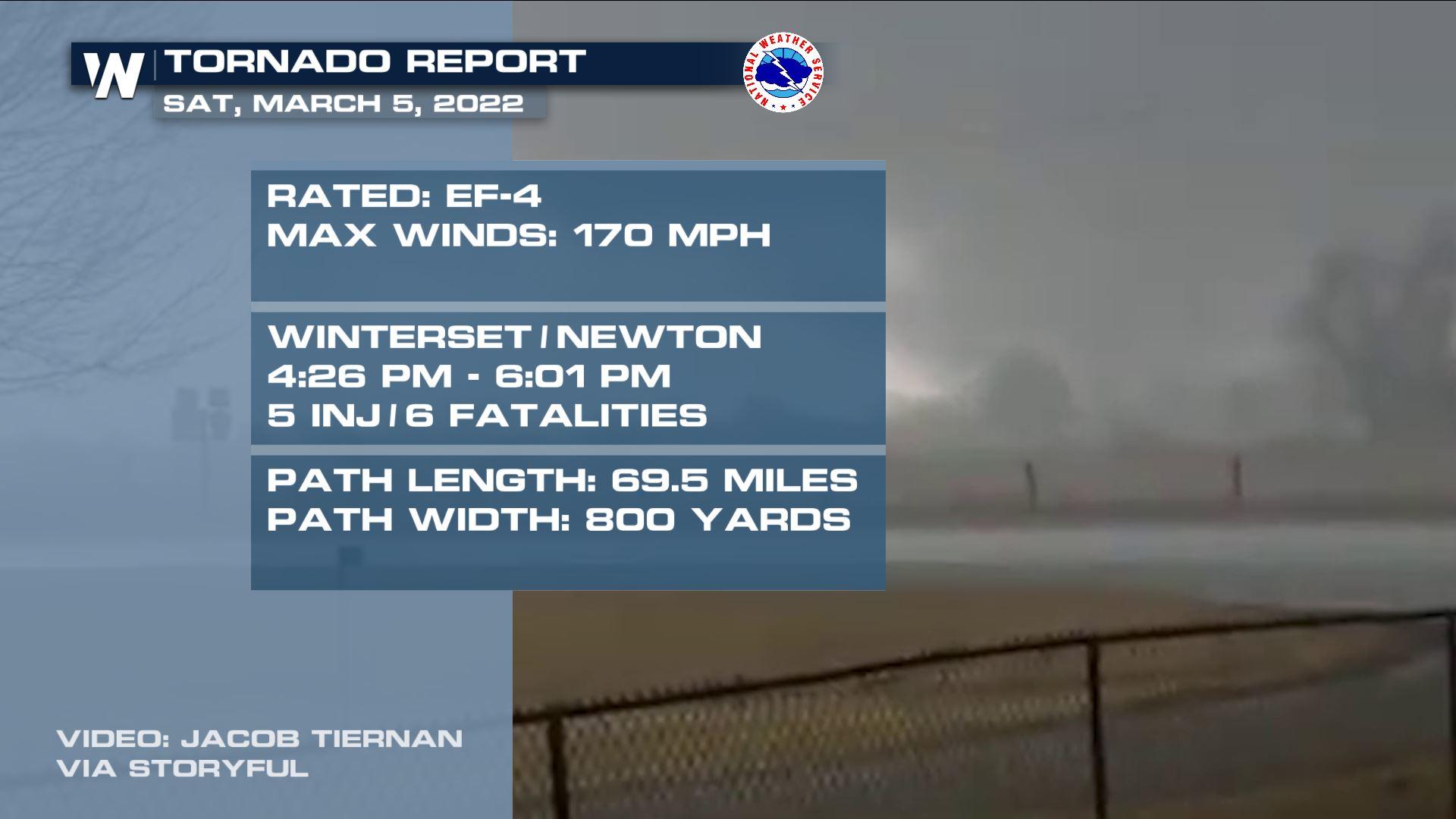
IOWA - The National Weather Service out of Des Moines, Iowa has released their preliminary damage survey for the Winterset/Newton Tornado and has rated it an EF-4 tornado with estimated peak winds of 170 mph. Unfortunately their were 5 injuries and 6 fatalities from this tornado.
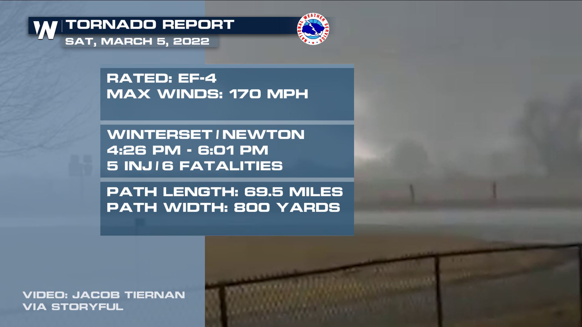 According to this tweet via NWS Des Moines, this is the first EF4 tornado in Iowa since 2013 and the second longest tornado path in Iowa since 1980.
[embed]https://twitter.com/NWSDesMoines/status/1500895001978408960?s=20&t=A637MFQnMJZ9yJfqggY-uw[/embed]
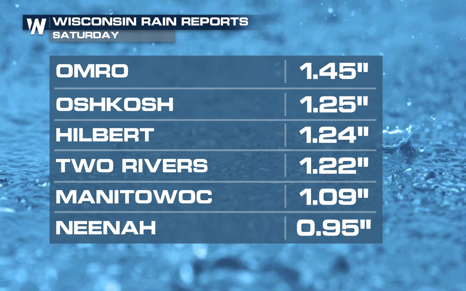
Meanwhile, this same storm system brought heavy ice to areas just a bit farther north across the Upper Midwest.
According to this tweet via NWS Des Moines, this is the first EF4 tornado in Iowa since 2013 and the second longest tornado path in Iowa since 1980.
[embed]https://twitter.com/NWSDesMoines/status/1500895001978408960?s=20&t=A637MFQnMJZ9yJfqggY-uw[/embed]
Meanwhile, this same storm system brought heavy ice to areas just a bit farther north across the Upper Midwest.
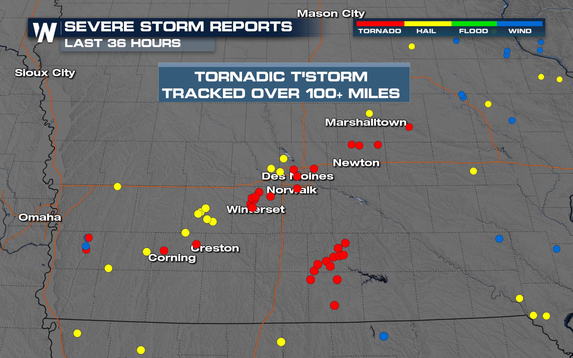 One thunderstorm was tornado-warned for about four consecutive hours on Saturday, from the southwest of Des Moines, Iowa and all the way (nearly) to the Mississippi River. As of Saturday evening, there were about 30 reports of tornadoes, about 20 reports of large hail, and about 5 reports of damaging straight-line winds.
https://twitter.com/WeatherNation/status/1500259871165345792
One thunderstorm was tornado-warned for about four consecutive hours on Saturday, from the southwest of Des Moines, Iowa and all the way (nearly) to the Mississippi River. As of Saturday evening, there were about 30 reports of tornadoes, about 20 reports of large hail, and about 5 reports of damaging straight-line winds.
https://twitter.com/WeatherNation/status/1500259871165345792
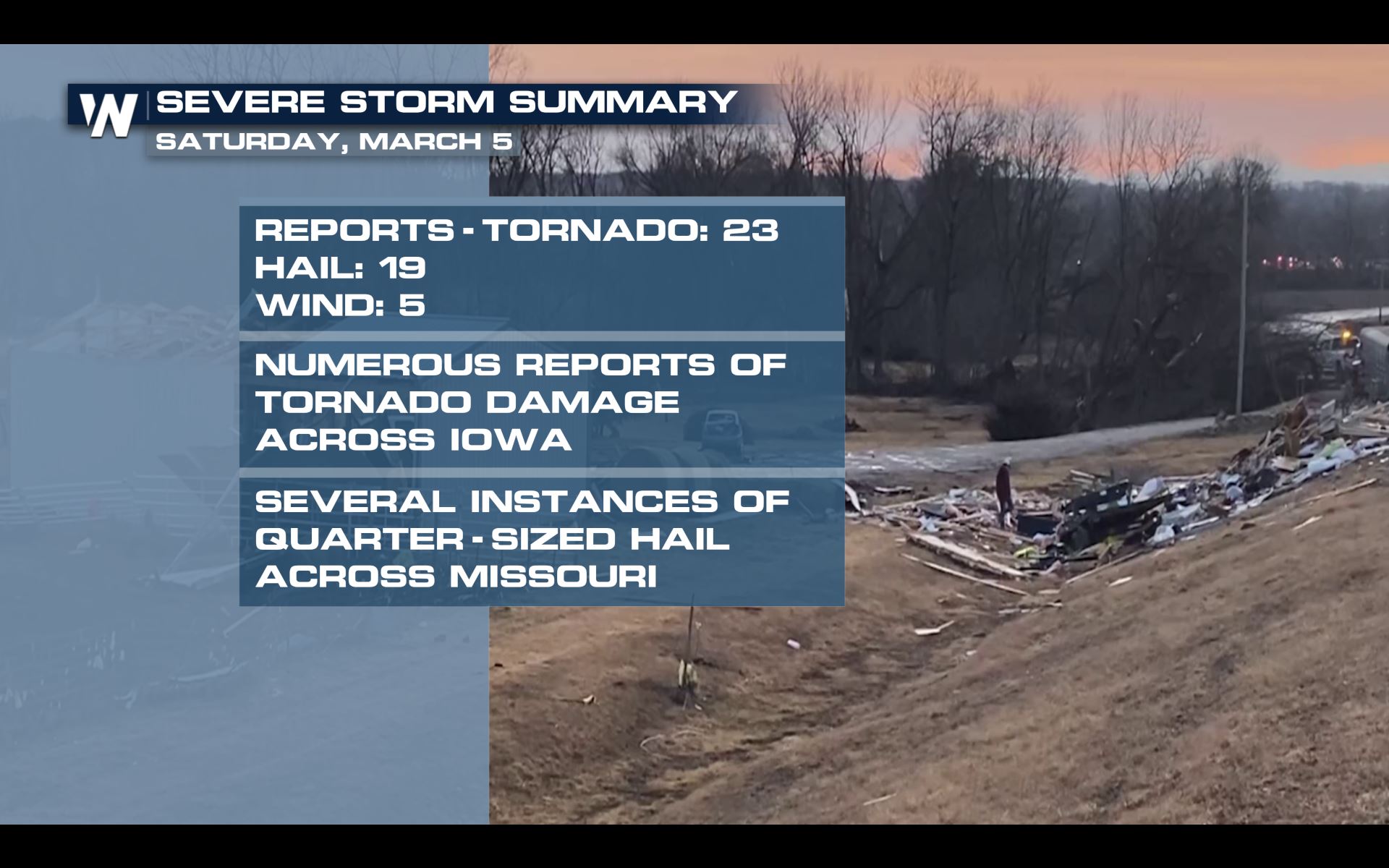 Unfortunately, these storms did damage. Numerous counties across Iowa reported damage from the apparent tornadoes. Farther south into Missouri, hail was the bigger story with about a dozen reports of hail up to one inch in diameter.
https://twitter.com/WeatherNation/status/1500275742550237190
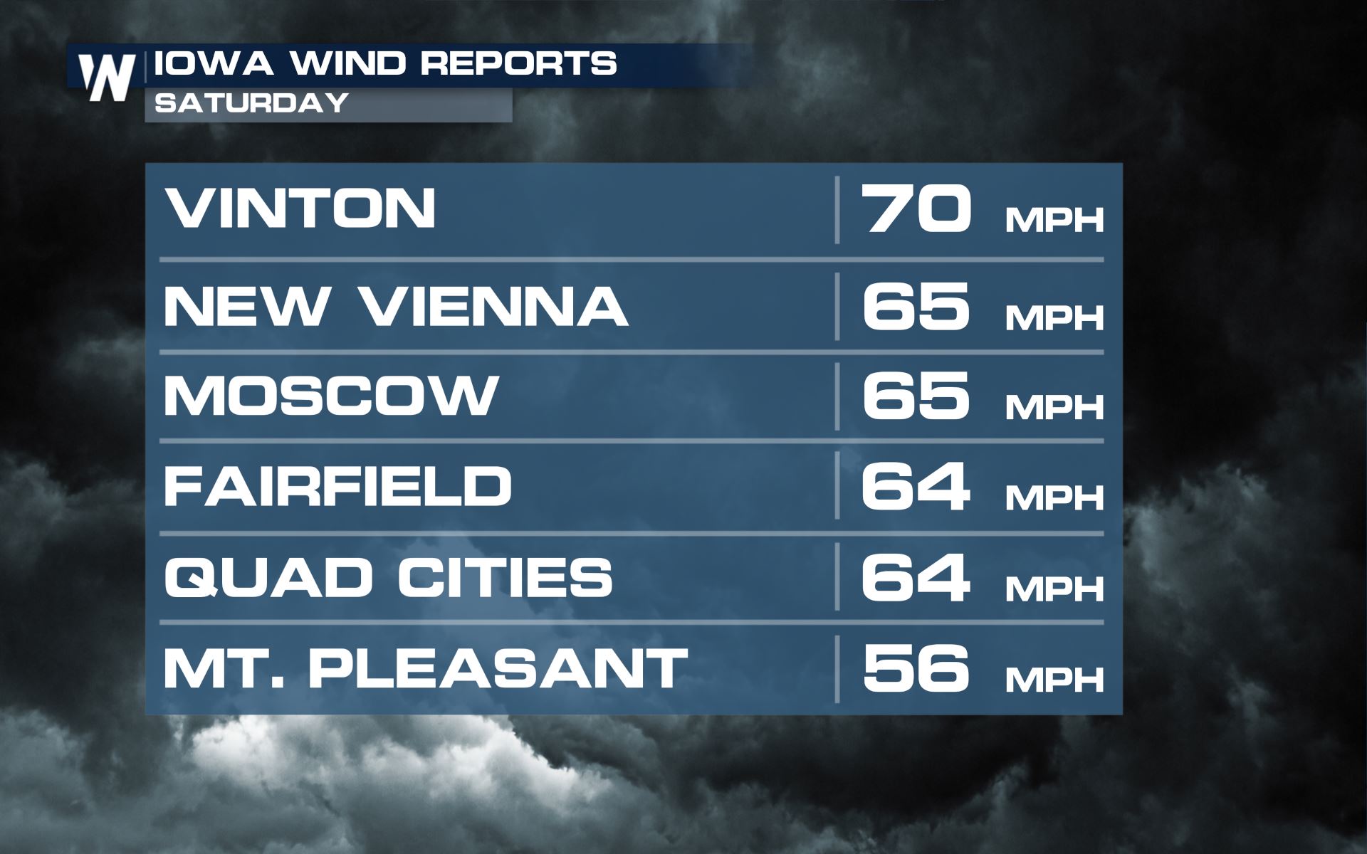
Wind reports in the state of Iowa were upwards of 70 miles per hour. Those reports came in with the severe thunderstorms containing straight-line, damaging wind gusts. In the tornadoes, winds of at least 100 mph, possibly up to 150 mph, were estimated.
Unfortunately, these storms did damage. Numerous counties across Iowa reported damage from the apparent tornadoes. Farther south into Missouri, hail was the bigger story with about a dozen reports of hail up to one inch in diameter.
https://twitter.com/WeatherNation/status/1500275742550237190
Wind reports in the state of Iowa were upwards of 70 miles per hour. Those reports came in with the severe thunderstorms containing straight-line, damaging wind gusts. In the tornadoes, winds of at least 100 mph, possibly up to 150 mph, were estimated.
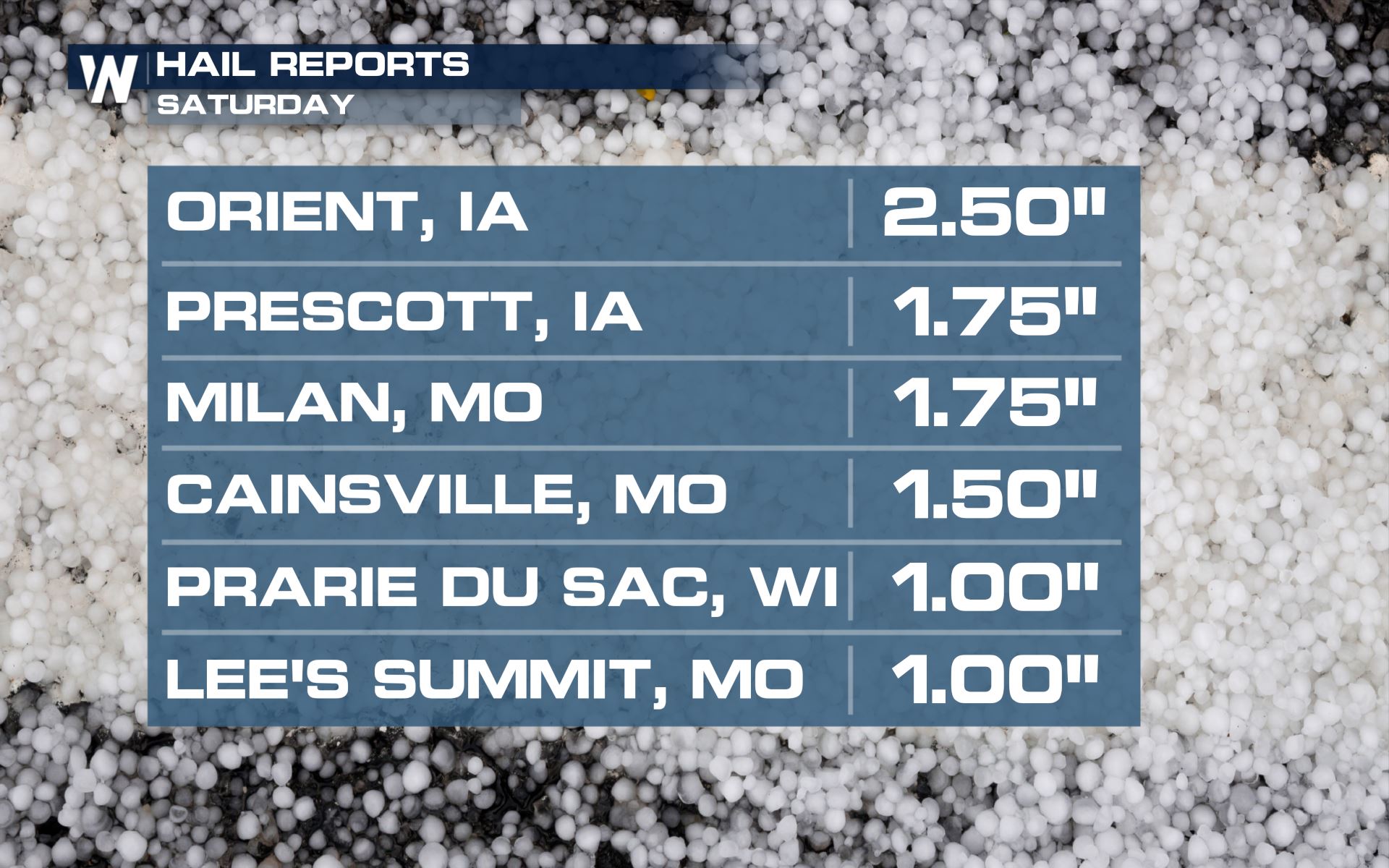
 There were some massive hailstones that fell from the sky too. Unfortunately once again, it was Iowa that was front and center for the largest hailstones to fall.
 Finally, rainfall was heavy in a short amount of time. We checked in with WeatherNation Field Meteorologist Tim Jones, who said ground conditions were quite muddy due to the heavy rainfall. These muddy spots were the same locations that had tornado damage.
 In the coming days, the National Weather Service will conduct storm surveys to conclude how large the tornadoes were on Saturday, plus how long they were on the ground and what rating they will be given. Stay with us as we bring you those updates.
According to this tweet via NWS Des Moines, this is the first EF4 tornado in Iowa since 2013 and the second longest tornado path in Iowa since 1980.
[embed]https://twitter.com/NWSDesMoines/status/1500895001978408960?s=20&t=A637MFQnMJZ9yJfqggY-uw[/embed]
Meanwhile, this same storm system brought heavy ice to areas just a bit farther north across the Upper Midwest.
One thunderstorm was tornado-warned for about four consecutive hours on Saturday, from the southwest of Des Moines, Iowa and all the way (nearly) to the Mississippi River. As of Saturday evening, there were about 30 reports of tornadoes, about 20 reports of large hail, and about 5 reports of damaging straight-line winds.
https://twitter.com/WeatherNation/status/1500259871165345792
Unfortunately, these storms did damage. Numerous counties across Iowa reported damage from the apparent tornadoes. Farther south into Missouri, hail was the bigger story with about a dozen reports of hail up to one inch in diameter.
https://twitter.com/WeatherNation/status/1500275742550237190
Wind reports in the state of Iowa were upwards of 70 miles per hour. Those reports came in with the severe thunderstorms containing straight-line, damaging wind gusts. In the tornadoes, winds of at least 100 mph, possibly up to 150 mph, were estimated.
There were some massive hailstones that fell from the sky too. Unfortunately once again, it was Iowa that was front and center for the largest hailstones to fall.
Finally, rainfall was heavy in a short amount of time. We checked in with WeatherNation Field Meteorologist Tim Jones, who said ground conditions were quite muddy due to the heavy rainfall. These muddy spots were the same locations that had tornado damage.
In the coming days, the National Weather Service will conduct storm surveys to conclude how large the tornadoes were on Saturday, plus how long they were on the ground and what rating they will be given. Stay with us as we bring you those updates.All Weather News
More
East Gears Up for Stormy, Wet Weekend
A low pressure system crashing through the Mi
1 Aug 2026 9:15 PM


Flooding, Severe Storms Target the Midwest Again
After an active week of storms across the nor
1 Aug 2026 1:40 AM

After Reaching Category 5, Genevieve Weakens in the Pacific
PacificFausto is now a post-tropical cyclone.
31 Jul 2026 1:30 AM

Flooding Risk Increases as Heavy Rain Targets the Tri-State Area
Tuesday, heavy rainfall moved across the Nort
30 Jul 2026 12:25 AM

Severe Weather: Energy From the Midwest Now in the Southeast
UPPER MIDWEST - Through Monday, dangerous tor
29 Jul 2026 10:30 PM