Scientists To Launch New Tornado Research Mission
Special Stories
14 May 2019 2:22 AM
Researchers are about to embark on a new research project aimed at understanding the relationships between severe thunderstorms and how tornadoes form across the Great Plains with the goal of improving forecasts.
https://twitter.com/NOAANSSL/status/1128281633289854976
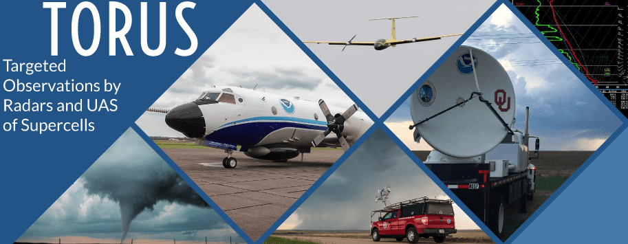
The upcoming project, Targeted Observation by Radars and Unmanned Aircraft Systems of Supercells, or TORUS, was discussed during a news conference earlier today (Tuesday, May 14th) and was followed by a public open house.
https://twitter.com/MesonetMan/status/1128289453611548673
The TORUS project involves more than 50 researchers using 20 tools to measure the atmosphere, including unmanned aircraft systems, mobile radars and NOAA’s WP-3D Orion “Hurricane Hunter” aircraft. Fieldwork will be conducted starting Wednesday, May 15th. The project will continue until June 16th throughout a 367,000-square-mile area of the Central Great Plains from North Dakota to Texas and Iowa to Wyoming and Colorado.
https://twitter.com/MesonetMan/status/1127732037811621889
Multiple research teams will follow severe thunderstorms to study how factors like wind speed, temperature, humidity and pressure may reveal the small-scale structures in a supercell storm and how it contributes to tornado formation. The goal is to use the data collected to improve conceptual models of supercell thunderstorms. Aims of the project include measuring and observing the frequency of changes in the atmosphere and relationships between the different atmospheric boundary layers.
Roughly a dozen radar, ballooning, unmanned aerial vehicle, and ground-based observations teams will travel into the storm, along with a team in the NOAA P-3 Hurricane Hunter flying just outside the storm, to provide a data-driven, multi-dimensional view of each storm system.
https://twitter.com/DoubleBnICT/status/1128336291899346947
Among the tools used in the project are swarms of radiosondes that take measurements of the atmosphere. The radiosondes are attached to balloons that are much smaller than traditional weather balloons. As many as 100 can be tracked within the storm at once.
Funded by NOAA and the National Science Foundation, the project is led by the University of Nebraska-Lincoln. Partner institutions are the University of Colorado Boulder, Texas Tech University, NOAA’s National Severe Storms Laboratory, NOAA’s Office of Marine and Aviation Operations, and the University of Oklahoma Cooperative Institute for Mesoscale Meteorological Studies.
Information from NSSL TORUS and NSSL Blog
Edited for WeatherNation by Meteorologist Mace Michaels
All Weather News
More
Severe Storms Target the Midwest to the Northeast
UPPER MIDWEST - Dangerous tornadoes have alre
27 Jul 2026 6:35 PM


Tropics: Fausto Heads towards Hawaii; Genevieve Cat 4 Hurricane
Atlantic BasinBertha has dissipated after mov
27 Jul 2026 3:00 PM

Southeast Flood Risk Lingers Near Stalled Front
A stalled boundary over the Southeast will ke
25 Jul 2026 10:55 AM

Another Round of Storms Targets the Northeast
Tuesday brought severe weather again across p
23 Jul 2026 1:15 AM

Another Round of Severe Weather for the Upper Midwest and Great Lakes
The upper-level low train continues to keep t
21 Jul 2026 1:45 AM