September Climate Recap - Storms and Heat
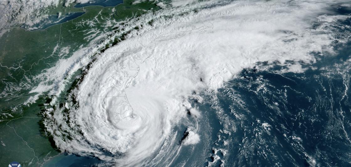
[Hurricane Dorian made landfall at Hatteras, North Carolina, on September 6, 2019, with maximum sustained winds estimated near 90 mph. From NOAA]
[NOAA] Despite being the start of meteorological autumn, September felt more like a summer swelter across much of the contiguous United States. The month was also drier than normal, but 2019 continued its soggy stretch with the wettest January through September period (YTD) ever recorded.
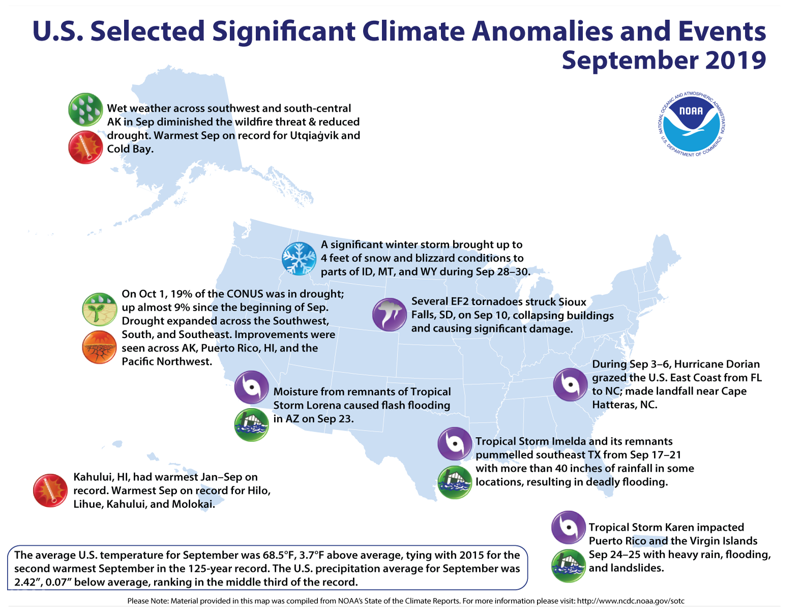
The U.S. also experienced four new weather disasters since May, each exceeding $1 billion: Hurricane Dorian, Tropical Storm Imelda, a southern/eastern severe weather outbreak, and flooding of the Arkansas River that impacted Arkansas, Oklahoma and Kansas.
Here are more highlights from NOAA’s latest monthly U.S. Climate Report:
Climate by the numbers
September 2019
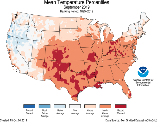
The average temperature for September across the contiguous U.S. was 68.5 degrees F (3.7 degrees above the 20th-century average), which ties with 2015 as the second warmest September on record.
After a more mild August, Alaska had an average temperature that ranked third warmest for September. Near-average temperatures were present across much of the West and in Maine.
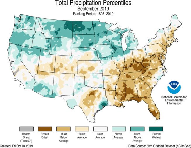
The average precipitation for September in the contiguous U.S. was 2.42 inches (0.07 inch below average), which puts the month in the middle third of the 125-year record.
Wetter-than-normal conditions were found from the West Coast to the northern Plains and Great Lakes. North Dakota had its wettest September on record.
Record dry conditions were present across Mississippi, Alabama, Georgia, Florida, Kentucky and West Virginia.
Year to date: January through September
The average U.S. temperature for the year to date (January through September) was 55.8 degrees F, 0.8 degrees above the 20th-century average, which ranked in the warmest third of the record.The contiguous U.S. had its wettest year to date on record at 27.96 inches. Above- to much-above-average precipitation stretched from coast to coast, with record rainfall across South Dakota and Michigan.
More notable climate events
-
The long-term wet streak continues: Average precipitation across the contiguous U.S. for the 12-month period (October 2018 through September 2019) was 36.45 inches, 6.51 inches above average. This ranks as the wettest 12-month period and the fifth wettest among all 12-month periods on record.
-
Hurricane Dorian made landfall at Hatteras, North Carolina, on September 6, with maximum sustained winds estimated near 90 mph.
-
Tropical Storm Imelda made landfall near Freeport, Texas, on September 18, just 45 minutes after becoming a tropical storm. Widespread flooding resulted from the system stalling over southeast Texas for four days.
-
An early winter snow storm impacted the northern Rockies from September 28–30. Between 1 and 4 feet of snow fell across parts of Idaho, Montana and Wyoming, shattering September records across the region.


