Severe Storm Threat to Start the Work Week
Special Stories
11 Aug 2019 4:00 PM
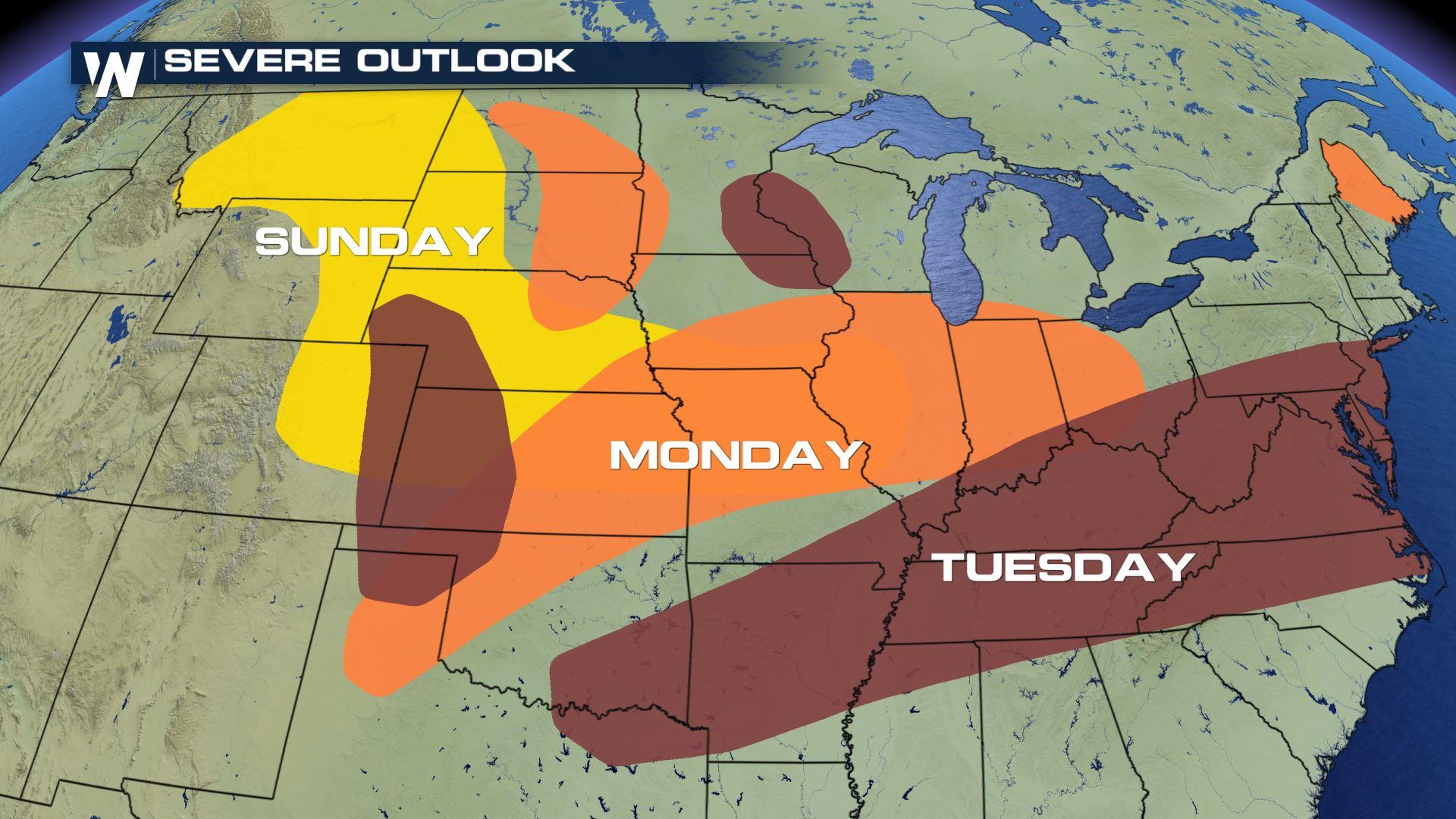
Severe thunderstorms will track across the central and eastern United States over the next couple days. Severe thunderstorms remain a concern for the Central and Northern High Plains for the rest of Sunday. You can read more on that forecast here.
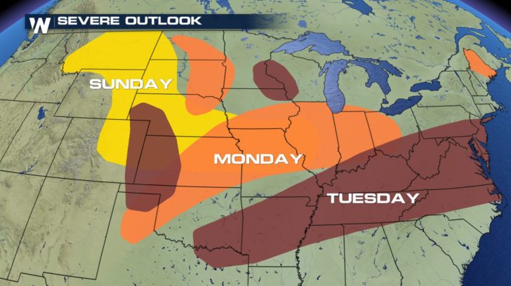 The low-pressure system and cold front responsible for Sunday's storms will continue to track to the east into Monday. Instability will continue to grow ahead of the cold front, making conditions prime for severe weather development.
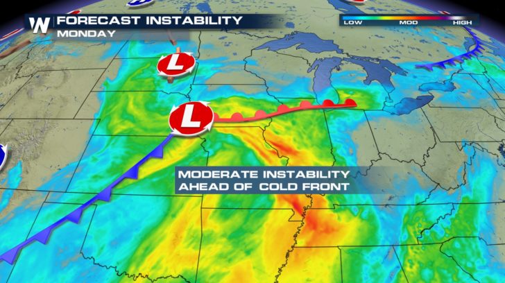 The outlook for the Dakotas will mainly be for the morning hours on Monday. Later in the afternoon, the greatest threat for severe weather will be centered over Illinois. Damaging winds, large hail, tornadoes, and heavy rainfall are all possible.
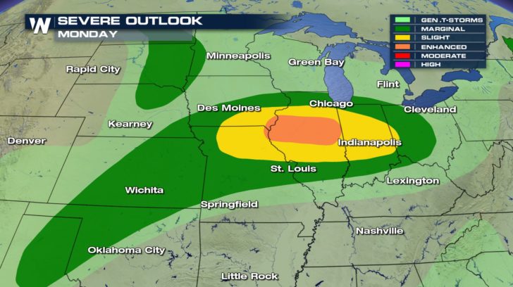 Here's a look at Monday's forecast. The strongest storms look to fire up late evening over Iowa and Illinois.
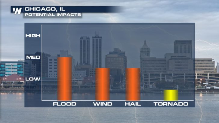
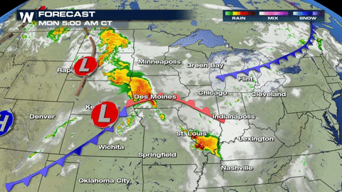 Storms will impact several cities and many folks on their commutes. In Chicago, the full range of severe weather is possible. There is also an increased risk of flooding due to the potential for heavy rainfall.
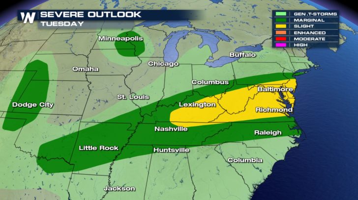
 By Tuesday, conditions will dry up for folks in the Windy City...
 ....But storms will move into the Tennessee River Valley and Mid-Atlantic.
 Don't forget to watch WeatherNation on-air for live severe weather coverage over the next several days.
-Meteorologist Viki Knapp
Don't forget to watch WeatherNation on-air for live severe weather coverage over the next several days.
-Meteorologist Viki Knapp
The low-pressure system and cold front responsible for Sunday's storms will continue to track to the east into Monday. Instability will continue to grow ahead of the cold front, making conditions prime for severe weather development.
The outlook for the Dakotas will mainly be for the morning hours on Monday. Later in the afternoon, the greatest threat for severe weather will be centered over Illinois. Damaging winds, large hail, tornadoes, and heavy rainfall are all possible.
Here's a look at Monday's forecast. The strongest storms look to fire up late evening over Iowa and Illinois.
Storms will impact several cities and many folks on their commutes. In Chicago, the full range of severe weather is possible. There is also an increased risk of flooding due to the potential for heavy rainfall.
By Tuesday, conditions will dry up for folks in the Windy City...
....But storms will move into the Tennessee River Valley and Mid-Atlantic.
Don't forget to watch WeatherNation on-air for live severe weather coverage over the next several days.
-Meteorologist Viki KnappAll Weather News
More
Severe Weather: Energy From the Midwest Now in the Southeast
UPPER MIDWEST - Through Monday, dangerous tor
29 Jul 2026 2:25 PM


Flooding Risk Increases as Heavy Rain Targets the Tri-State Area
Tuesday, heavy rainfall moved across the nort
29 Jul 2026 2:00 PM

Tropics: Fausto Heads towards Hawaii; Genevieve a Major Hurricane
PacificTropical Depression Fausto continues t
29 Jul 2026 10:15 AM


Southeast Flood Risk Lingers Near Stalled Front
A stalled boundary over the Southeast will ke
25 Jul 2026 10:55 AM

Another Round of Storms Targets the Northeast
Tuesday brought severe weather again across p
23 Jul 2026 1:15 AM