Severe Threat for Ohio Valley on Monday
Top Stories
20 May 2018 4:17 PM
Severe weather has been ongoing across parts of the mid-south so far today with one confirmed tornado that touched down in Williamson County, Texas early on Sunday morning. Isolated damage was reported with this tornado and survey teams are assessing the damage.
https://twitter.com/WeatherNation/status/998208123742531587
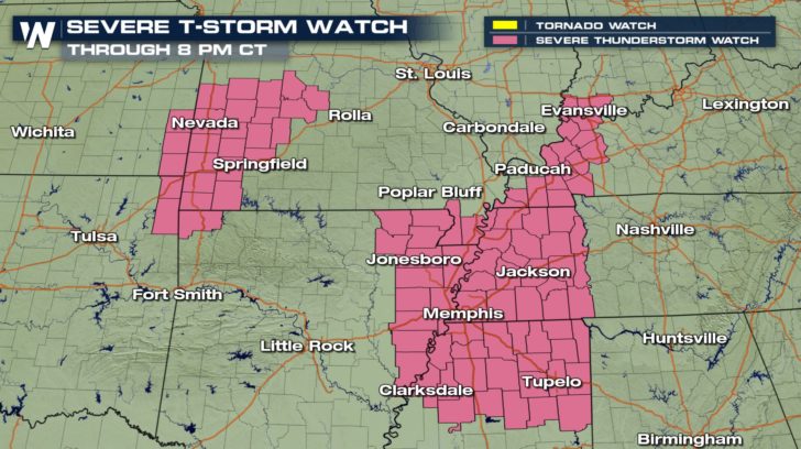
A surface low pressure and corresponding cold front are triggering more strong to severe storms across parts of the Midwest today with heavy downpours and large hail being reported north of Memphis, TN. A Severe T-Storm Watch is in place until later this evening.
 The energy with this system will continue to slide east overnight tonight and be the providing focus for severe weather for Monday afternoon for some major cities in the Ohio Valley.
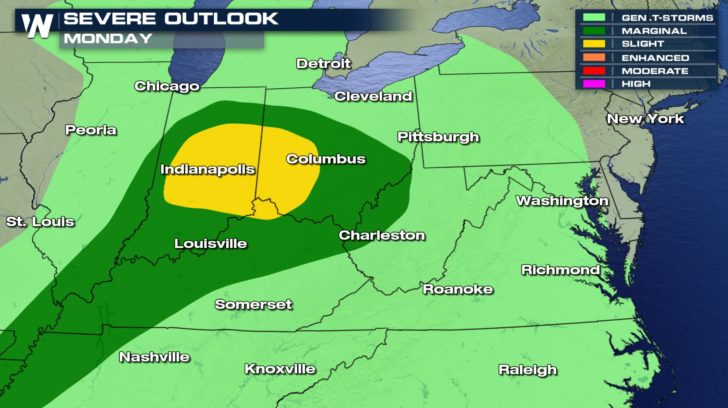
 Major cities such as Indianapolis, Cincinnati and Columbus are included in a slight risk (yellow shaded area) for severe storms indicating all modes of severe weather will be possible. This means numerous severe storms containing large hail, damaging winds and a few isolated tornadoes will be likely by the afternoon hours on Monday.
Stay weather alert!
Meteorologist Merry Matthews
 The energy with this system will continue to slide east overnight tonight and be the providing focus for severe weather for Monday afternoon for some major cities in the Ohio Valley.
 Major cities such as Indianapolis, Cincinnati and Columbus are included in a slight risk (yellow shaded area) for severe storms indicating all modes of severe weather will be possible. This means numerous severe storms containing large hail, damaging winds and a few isolated tornadoes will be likely by the afternoon hours on Monday.
Stay weather alert!
Meteorologist Merry Matthews
All Weather News
More