Severe Thunderstorm Watch Issued for Florida
Special Stories
14 Dec 2018 3:47 PM
A severe thunderstorm watch was issued for west-central Florida Friday, lasting until 10 p.m. eastern.
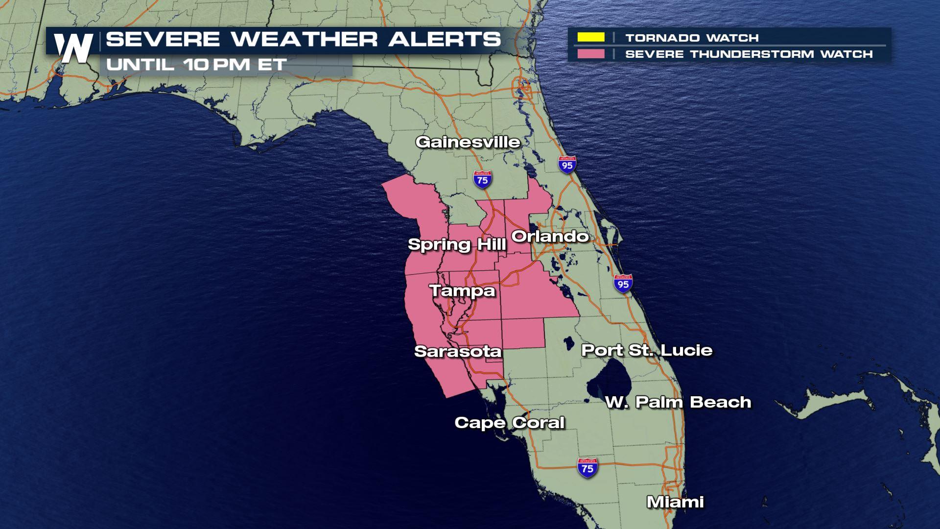
 The alerts as of 5:30 p.m. eastern Friday
A severe thunderstorm watch means that there is a potential for severe thunderstorms carrying damaging wind, hail, and/or an isolated tornado. When you hear a 'warning' that is when a storm has formed and is moving toward a certain location. Listen out for any warnings this evening!
Related Story: Southeast Seeing Threats From Heavy Rain and Severe Storms Today
Here's the estimated timing of the storms:
The alerts as of 5:30 p.m. eastern Friday
A severe thunderstorm watch means that there is a potential for severe thunderstorms carrying damaging wind, hail, and/or an isolated tornado. When you hear a 'warning' that is when a storm has formed and is moving toward a certain location. Listen out for any warnings this evening!
Related Story: Southeast Seeing Threats From Heavy Rain and Severe Storms Today
Here's the estimated timing of the storms:
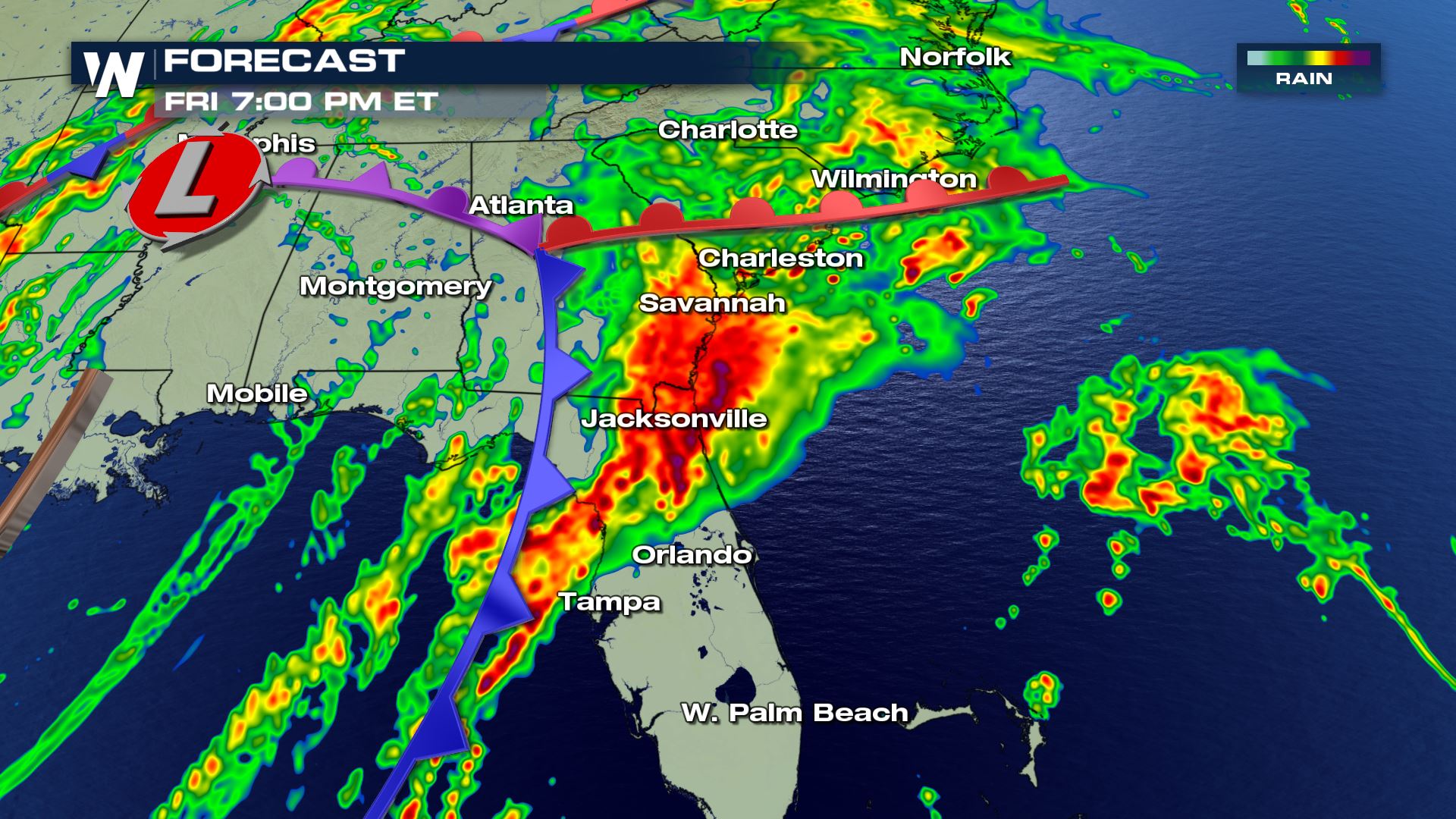 Forecast radar at 7 p.m. eastern Friday where yellows, oranges, and reds show the heaviest rain and thunderstorms.
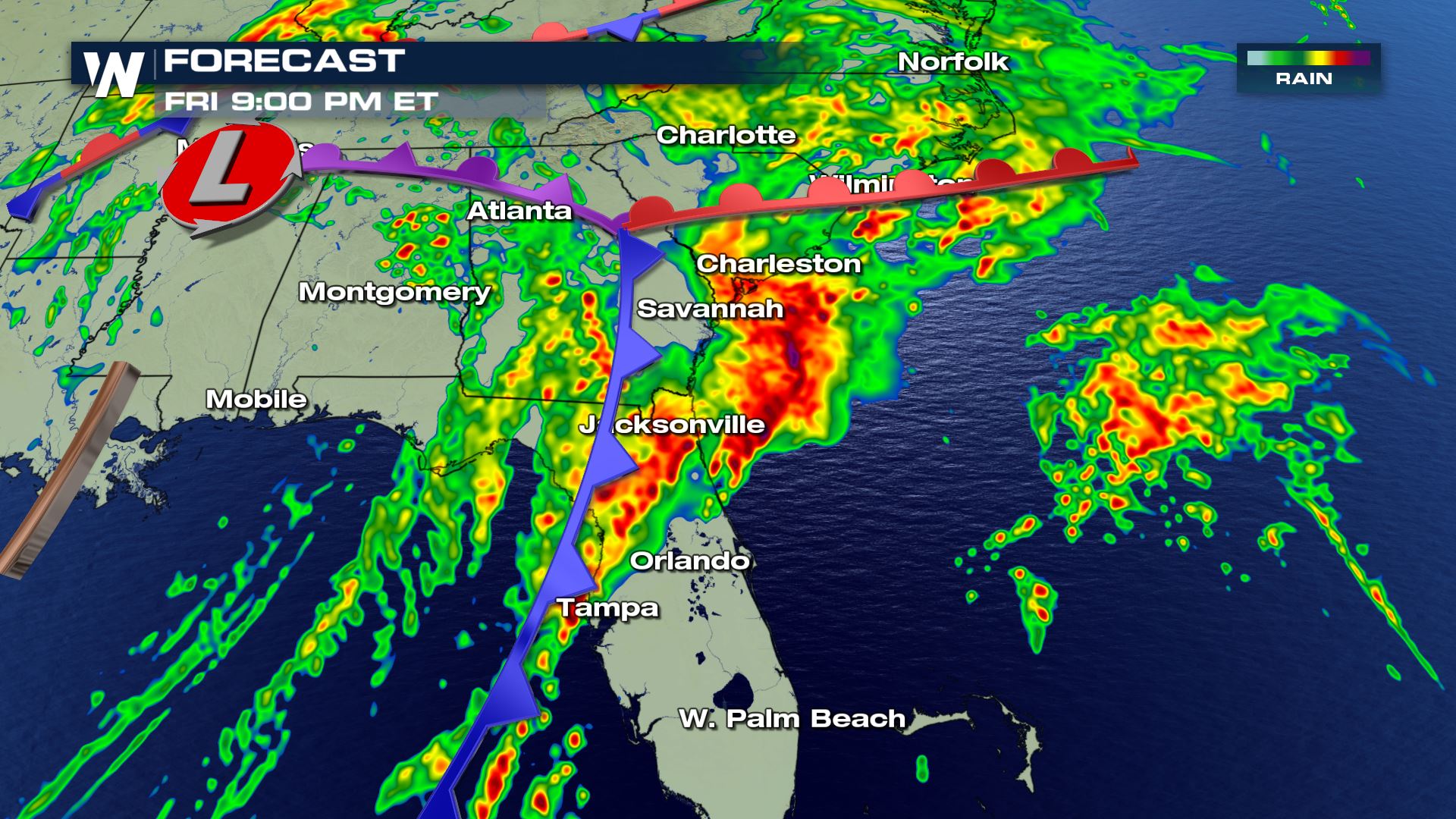 Forecast radar at 9 p.m. eastern Friday where yellows, oranges, and reds show the heaviest rain and thunderstorms.
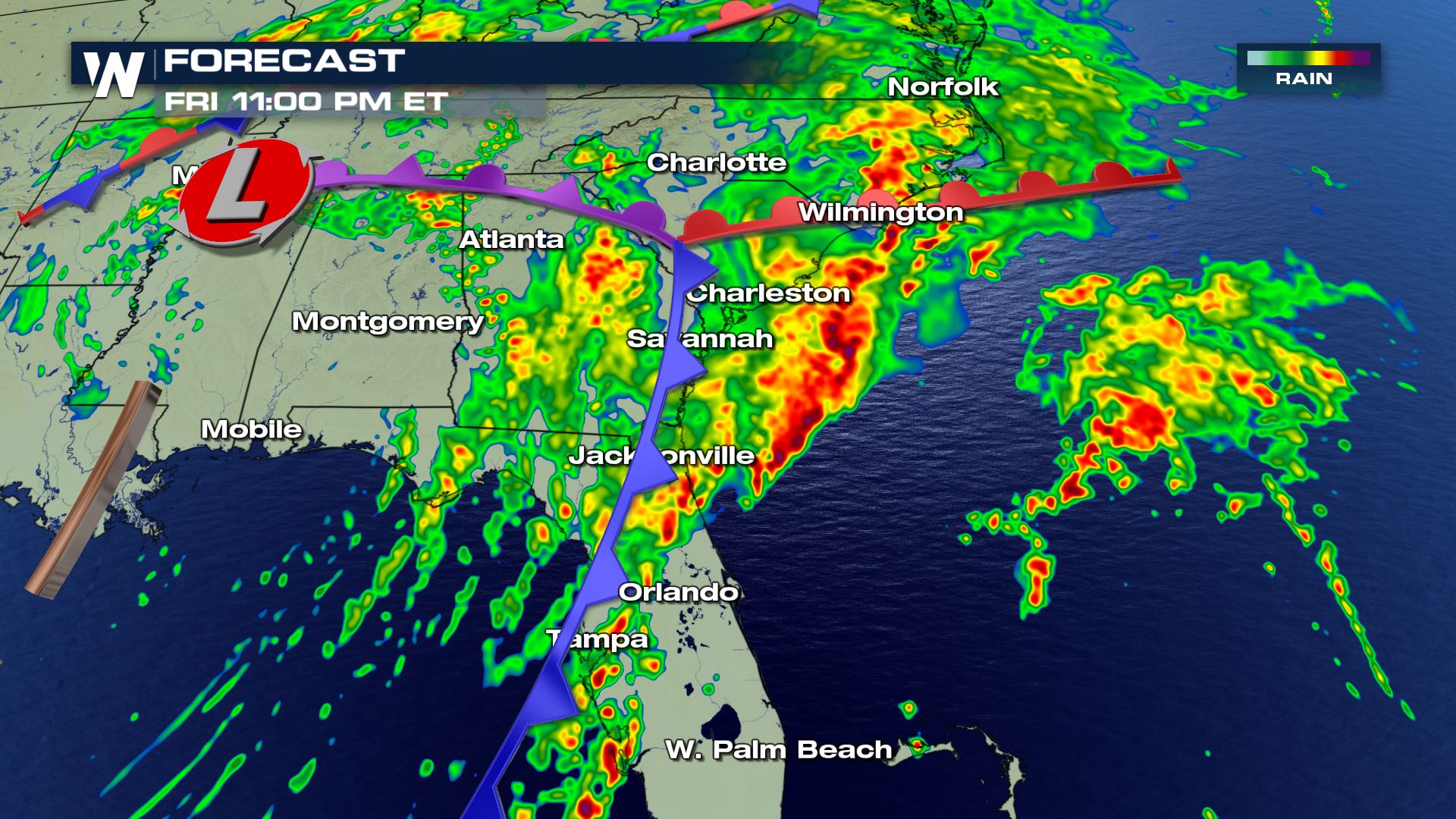 Forecast radar at 11 p.m. eastern Friday where yellows, oranges, and reds show the heaviest rain and thunderstorms.
Individual thunderstorms will move to the northeast between 30 and 40 miles per hour. The entire line (along the blue-colored cold front here) will be moving very slowly to the east. If you don't get thunderstorms out of this, you'll likely get heavy rain!
Related Story: Big Storm Brings Big Variety of Weather
Forecast radar at 11 p.m. eastern Friday where yellows, oranges, and reds show the heaviest rain and thunderstorms.
Individual thunderstorms will move to the northeast between 30 and 40 miles per hour. The entire line (along the blue-colored cold front here) will be moving very slowly to the east. If you don't get thunderstorms out of this, you'll likely get heavy rain!
Related Story: Big Storm Brings Big Variety of Weather
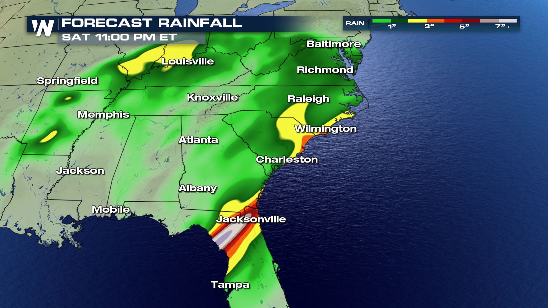 Forecast rainfall through Saturday evening, December 15 where yellow shows 2-3", orange 3-4", and reds 5"+
Pockets of flooding will accompany the severe weather threat through Friday night. Especially after dark, be weary of your surroundings and any hazardous weather that may be coming through!
Forecast rainfall through Saturday evening, December 15 where yellow shows 2-3", orange 3-4", and reds 5"+
Pockets of flooding will accompany the severe weather threat through Friday night. Especially after dark, be weary of your surroundings and any hazardous weather that may be coming through!
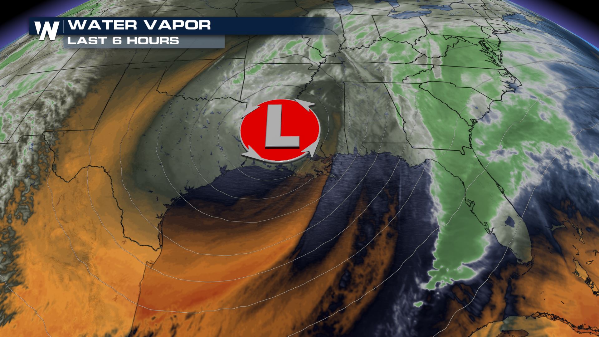 The water vapor image around 5 p.m. eastern Friday showed a large area of low pressure pressing along the Gulf of Mexico coastline. Out ahead of it (to the east, right) was plentiful moisture and heavy rain. That's where we'll have the greatest potential of a severe thunderstorm and pockets of flooding.
We'll continue to keep you updated on our Facebook and Twitter pages. If you happen to observe any noteworthy weather, feel free to let us know on those social media websites!
For WeatherNation, Meteorologist Steve Glazier
The water vapor image around 5 p.m. eastern Friday showed a large area of low pressure pressing along the Gulf of Mexico coastline. Out ahead of it (to the east, right) was plentiful moisture and heavy rain. That's where we'll have the greatest potential of a severe thunderstorm and pockets of flooding.
We'll continue to keep you updated on our Facebook and Twitter pages. If you happen to observe any noteworthy weather, feel free to let us know on those social media websites!
For WeatherNation, Meteorologist Steve Glazier
The alerts as of 5:30 p.m. eastern Friday
A severe thunderstorm watch means that there is a potential for severe thunderstorms carrying damaging wind, hail, and/or an isolated tornado. When you hear a 'warning' that is when a storm has formed and is moving toward a certain location. Listen out for any warnings this evening!
Related Story: Southeast Seeing Threats From Heavy Rain and Severe Storms Today
Here's the estimated timing of the storms:
Forecast radar at 7 p.m. eastern Friday where yellows, oranges, and reds show the heaviest rain and thunderstorms.
Forecast radar at 9 p.m. eastern Friday where yellows, oranges, and reds show the heaviest rain and thunderstorms.
Forecast radar at 11 p.m. eastern Friday where yellows, oranges, and reds show the heaviest rain and thunderstorms.
Individual thunderstorms will move to the northeast between 30 and 40 miles per hour. The entire line (along the blue-colored cold front here) will be moving very slowly to the east. If you don't get thunderstorms out of this, you'll likely get heavy rain!
Related Story: Big Storm Brings Big Variety of Weather
Forecast rainfall through Saturday evening, December 15 where yellow shows 2-3", orange 3-4", and reds 5"+
Pockets of flooding will accompany the severe weather threat through Friday night. Especially after dark, be weary of your surroundings and any hazardous weather that may be coming through!
The water vapor image around 5 p.m. eastern Friday showed a large area of low pressure pressing along the Gulf of Mexico coastline. Out ahead of it (to the east, right) was plentiful moisture and heavy rain. That's where we'll have the greatest potential of a severe thunderstorm and pockets of flooding.
We'll continue to keep you updated on our Facebook and Twitter pages. If you happen to observe any noteworthy weather, feel free to let us know on those social media websites!
For WeatherNation, Meteorologist Steve GlazierAll Weather News
More
Severe Storms in the Midwest Could Dampen Holiday Plans
NORTHERN PLAINS - A frontal system is expecte
4 Jul 2025 3:20 AM

Near Seasonal Temperatures for Many Come July 4th!
AAA is expecting over 70 million travelers to
4 Jul 2025 3:15 AM

NHC Monitoring Front in the Southeast Ahead of 4th of July
Tropical downpours for a long holiday weekend
4 Jul 2025 3:10 AM

Flossie is No More, Eastern Pacific Remains Active
Post Tropical FlossieThe National Hurricane C
4 Jul 2025 3:05 AM


Northwest Heat Met With Thunderstorm Risk
NORTHWEST - Today, portions of Montana are un
3 Jul 2025 12:00 AM

Severe Weather Threat Continues in the Midwest
It has been an active, severe season across t
30 Jun 2025 9:00 PM