Severe Thunderstorms Possible in the Plains

Special Stories
1 Apr 2020 9:29 AM
The North and Central Great Plains have the potential for severe thunderstorms, mainly in the afternoons, on Wednesday and Thursday.
A large, slow moving trough in the upper-levels of the atmosphere over Western Canada will create strong wind shear over the Dakotas and Northern Nebraska by Wednesday afternoon, as a cold front moves southeast at the surface. This could lead to a few high-based thunderstorms over parts of Nebraska and South Dakota Wednesday afternoon, capable of producing large hail and severe wind gusts.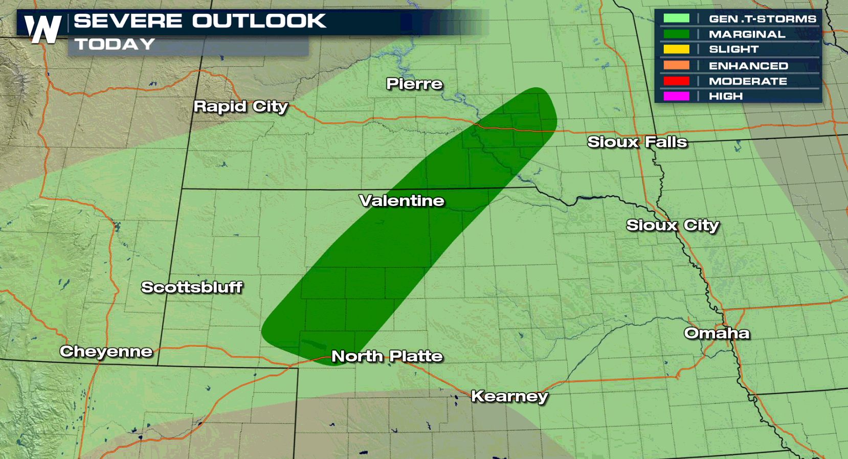 The Storm Prediction Center has issued a marginal risk for the areas in dark green. Thankfully, the threat for severe storms is not expected to last long past sunset, due to the front undercutting storms and improving stability in the lower levels.
On Thursday, the threat for severe storms shifts south into Kansas. The marginal risk issued by the Storm Prediction Center includes the towns of Salina, Hutchinson, and Great Bend.
The Storm Prediction Center has issued a marginal risk for the areas in dark green. Thankfully, the threat for severe storms is not expected to last long past sunset, due to the front undercutting storms and improving stability in the lower levels.
On Thursday, the threat for severe storms shifts south into Kansas. The marginal risk issued by the Storm Prediction Center includes the towns of Salina, Hutchinson, and Great Bend.
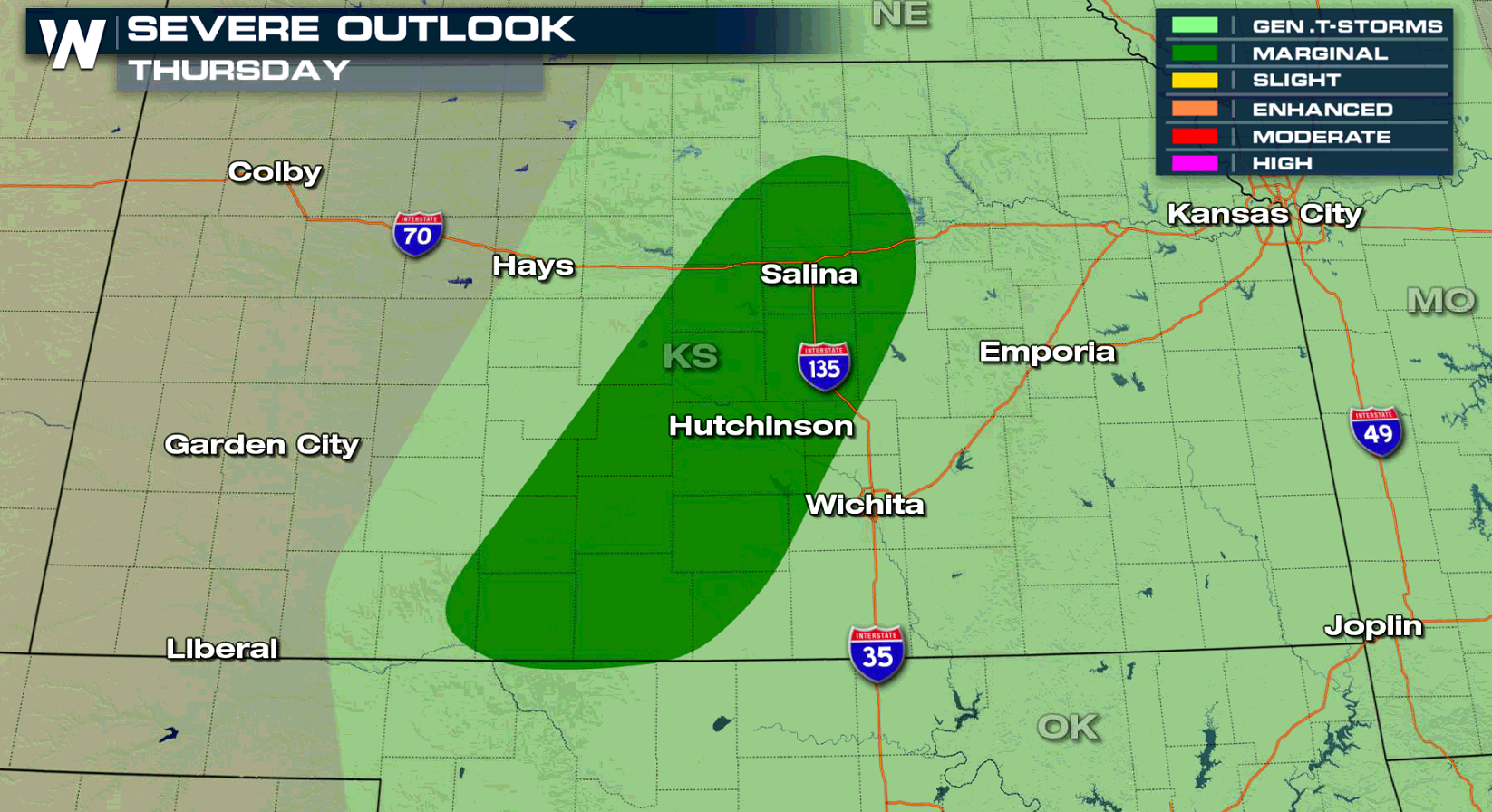 As a cold front continues to move southeast from the Northern Plains, moisture is expected to move north along a dryline stretching from West Texas into the Oklahoma Panhandle. This could lead to a few strong to severe thunderstorms, capable of producing large hail and severe strength winds, across Central Kansas and possibly Northwestern Oklahoma. This activity is also expected to wane quickly during the evening hours.
A few stronger storms will also be possible across Texas on Thursday before the risk for severe storms ramps up in the Lone Star State on Friday.
Stay with WeatherNation for the continuing coverage on the chance for severe storms.
As a cold front continues to move southeast from the Northern Plains, moisture is expected to move north along a dryline stretching from West Texas into the Oklahoma Panhandle. This could lead to a few strong to severe thunderstorms, capable of producing large hail and severe strength winds, across Central Kansas and possibly Northwestern Oklahoma. This activity is also expected to wane quickly during the evening hours.
A few stronger storms will also be possible across Texas on Thursday before the risk for severe storms ramps up in the Lone Star State on Friday.
Stay with WeatherNation for the continuing coverage on the chance for severe storms.
The Storm Prediction Center has issued a marginal risk for the areas in dark green. Thankfully, the threat for severe storms is not expected to last long past sunset, due to the front undercutting storms and improving stability in the lower levels.
On Thursday, the threat for severe storms shifts south into Kansas. The marginal risk issued by the Storm Prediction Center includes the towns of Salina, Hutchinson, and Great Bend.
As a cold front continues to move southeast from the Northern Plains, moisture is expected to move north along a dryline stretching from West Texas into the Oklahoma Panhandle. This could lead to a few strong to severe thunderstorms, capable of producing large hail and severe strength winds, across Central Kansas and possibly Northwestern Oklahoma. This activity is also expected to wane quickly during the evening hours.
A few stronger storms will also be possible across Texas on Thursday before the risk for severe storms ramps up in the Lone Star State on Friday.
Stay with WeatherNation for the continuing coverage on the chance for severe storms.All Weather News
More
Tropics: Tropical Storm Bertha Forms In the Atlantic, Eastern Pacific Active
In the Atlantic basin, we are keeping a very
21 Jul 2026 10:55 PM

Flash Flooding and Severe Weather for the Carolinas This Week
Another stalled front in the Carolinas is for
21 Jul 2026 10:50 PM

Another Round of Storms Targets the Northeast
Another cold front is dropping east and will
21 Jul 2026 10:00 PM

Pacific Northwest Fires Bringing Down the Air Quality
Conditions have been real dry out west. We've
21 Jul 2026 5:05 PM

Another Round of Severe Weather for the Upper Midwest and Great Lakes
The upper-level low train continues to keep t
21 Jul 2026 1:45 AM

Air Quality Improvements in the Forecast
Wildfires burning in Northwestern Ontario, Ca
20 Jul 2026 7:20 PM

Monsoon Moisture Brings Weekend Flood Threat
The monsoon has returned to the southwestern
19 Jul 2026 1:30 AM