Sierra Snowpack Looks Healthy Into Spring
Special Stories
4 Apr 2019 3:14 PM
https://www.youtube.com/watch?list=PLeod6x87Tu6exgDY_RFTzeEsG4msO1s2B&v=sK9-uGGNNuU
SOURCE: CA DWR
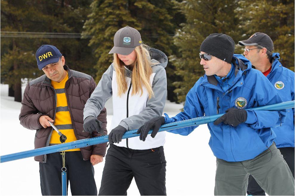
The California Department of Water Resources closely tracks Sierra Nevada snowpack through the state's wet season. Manual snow surveys are taken each month to determine not only the depth of snow, but also the Snow Water Equivalent (SWE). SWE is a critical factor in helping manage the state's water demands. The Sierra snowpack accounts for about 30 percent of California's water needs.
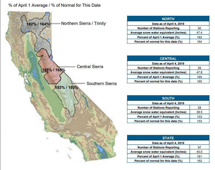
Since 1941, Phillips Station has provided a look into the health of the Sierra Snowpack. April first's survey recorded 106.5 inches of snow depth and an SWE of 51 inches, which is 200 percent of average for this location. As of April 4, statewide Sierra Snowpack is running 162% of average. SWE has nearly tripled since February 1.
 The above average snowpack can be attributed to a very wet winter. California saw more than 30 atmospheric river events since October.
“With full reservoirs and a dense snowpack, this year is practically a California water supply dream,” said DWR Director Karla Nemeth. “However, we know our long-term water supply reliability cannot rely on annual snowpack alone. It will take an all-of-the-above approach to build resiliency for the future.”
The Sierra's SWE generally peaks around April 1, so this month's measurement is a good indicator of 2019's water supply. However, an additional survey may need to take place in early May to account for additional snow in the forecast.
Is there such a thing as too much of a good thing? Officials warn about the potential for flooding into the spring if the snow melts too fast.
“With great water supply benefits comes some risk,” said Jon Ericson, DWR Chief of the Division of Flood Management. “Based on snowpack numbers, we have the potential for some minor flooding due to melting snow so we remind folks to always stay vigilant and aware.”
For WeatherNation, Meteorologist Karissa Klos
The above average snowpack can be attributed to a very wet winter. California saw more than 30 atmospheric river events since October.
“With full reservoirs and a dense snowpack, this year is practically a California water supply dream,” said DWR Director Karla Nemeth. “However, we know our long-term water supply reliability cannot rely on annual snowpack alone. It will take an all-of-the-above approach to build resiliency for the future.”
The Sierra's SWE generally peaks around April 1, so this month's measurement is a good indicator of 2019's water supply. However, an additional survey may need to take place in early May to account for additional snow in the forecast.
Is there such a thing as too much of a good thing? Officials warn about the potential for flooding into the spring if the snow melts too fast.
“With great water supply benefits comes some risk,” said Jon Ericson, DWR Chief of the Division of Flood Management. “Based on snowpack numbers, we have the potential for some minor flooding due to melting snow so we remind folks to always stay vigilant and aware.”
For WeatherNation, Meteorologist Karissa KlosAll Weather News
More


After Reaching Category 5, Genevieve Weakens in the Pacific
PacificFausto is now a post-tropical cyclone.
30 Jul 2026 12:00 PM

Flooding Risk Increases as Heavy Rain Targets the Tri-State Area
Tuesday, heavy rainfall moved across the Nort
30 Jul 2026 12:25 AM

Severe Weather: Energy From the Midwest Now in the Southeast
UPPER MIDWEST - Through Monday, dangerous tor
29 Jul 2026 10:30 PM

Southeast Flood Risk Lingers Near Stalled Front
A stalled boundary over the Southeast will ke
25 Jul 2026 10:55 AM

Another Round of Storms Targets the Northeast
Tuesday brought severe weather again across p
23 Jul 2026 1:15 AM