Soaking Rain Expected in Central U.S.
Special Stories
1 Jul 2019 8:29 PM
Showers and thunderstorms brought heavy rain to parts of the central U.S. on Monday. And more rain is expected to fall on Tuesday. This could lead to localized flooding in some areas.
A stalled front brought rain to the I-25 corridor, from Albuquerque to Denver, and northward into Wyoming and Montana. Heavy rain spread eastward across South Dakota and Nebraska, into Minnesota and Wisconsin.
 Some of the highest rainfall totals were found in Wyoming, South Dakota, Minnesota, and Wisconsin.
 The forecast is calling for a line of showers and storms to continue overnight into Tuesday morning. It appears the line will set up from eastern Colorado, across Nebraska, and run all the way into western Michigan. Severe storms are not expected overnight. However, heavy rain, lightning, and gusty winds will all be possible.
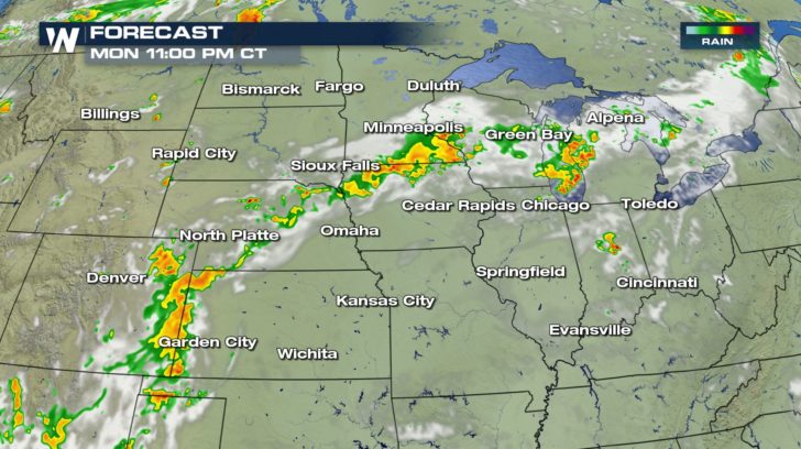 Thunderstorms will re-fire on Tuesday afternoon in the same general areas along the front. Some storms may be severe, with damaging winds and large hail. A few isolated tornadoes will also be possible.
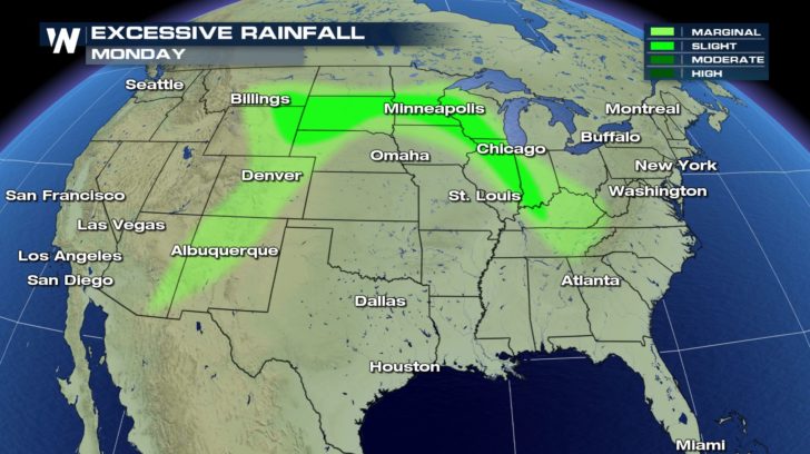
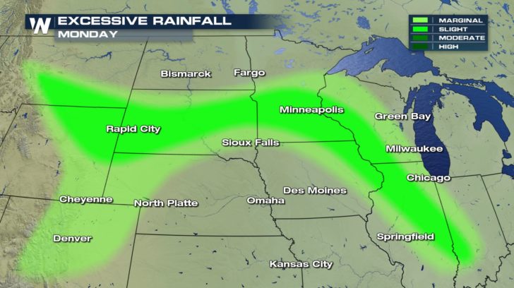
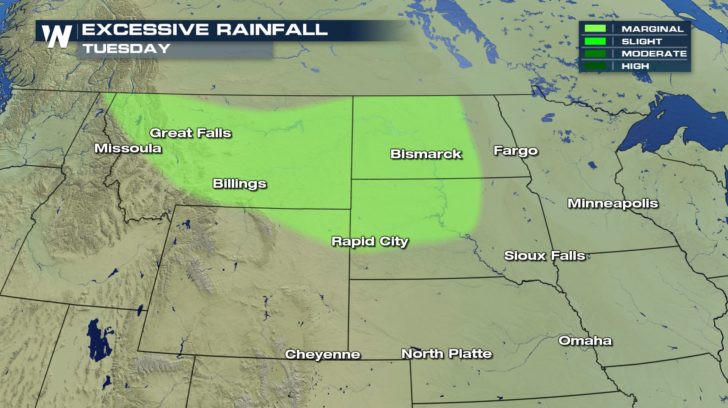
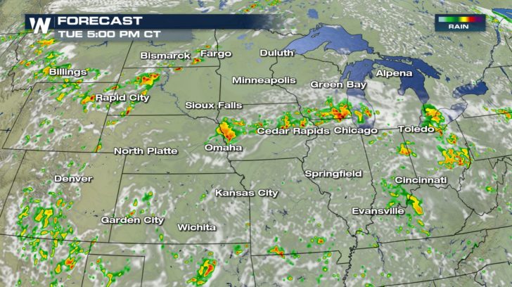 Heavy rain will set up in two areas. The first area is the High Plains, from Montana into the western Dakotas.
 The second area for heavy rainfall will be well to the east, from Omaha, through Chicago, and into Pennsylvania. Cities such as Buffalo, Philadelphia, and Pittsburgh could see heavy rain and thunderstorms.
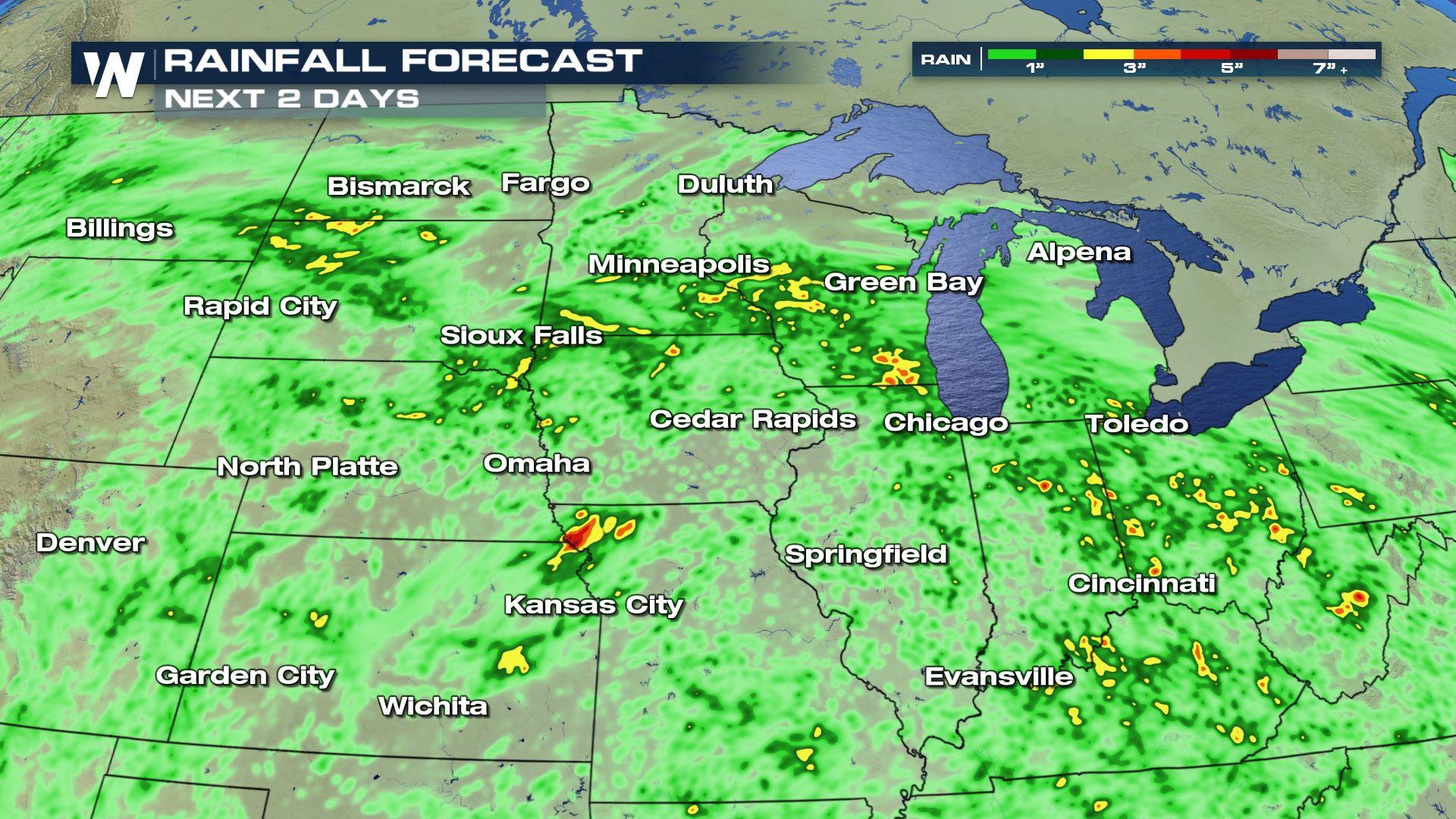
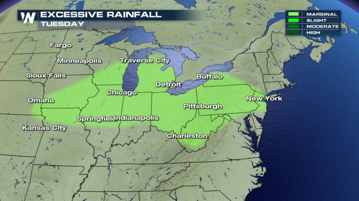 Over the next two days, rain will be widespread, from the High Plains, into the Midwest, across the Ohio Valley, and into parts of the northeast. Rainfall totals could reach 2 to 3 inches where you see the yellow and orange/red shaded areas. Dark Green shaded areas will receive around an inch of rain.
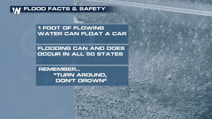
 With all of this rain in the forecast, street flooding will be a distinct possibility. Please keep in mind how dangerous flooding can be. It only takes one foot of flowing water to float most vehicles. Flooding can and does occur in all 50 states. And whenever you come across a road with substantial flooding, "Turn Around, Don't Drown"! It's difficult to know the depth of the water. And it's impossible to know the road condition beneath the water. In fact, the road may not even be there!
 Stay tuned to WeatherNation for complete storm coverage. You can watch on the Dish Network, Roku, Fire TV, Apple TV, Pluto TV, and on any mobile device with the free WeatherNation App.
For WeatherNation: Meteorologist Matt Monroe
Stay tuned to WeatherNation for complete storm coverage. You can watch on the Dish Network, Roku, Fire TV, Apple TV, Pluto TV, and on any mobile device with the free WeatherNation App.
For WeatherNation: Meteorologist Matt Monroe
Some of the highest rainfall totals were found in Wyoming, South Dakota, Minnesota, and Wisconsin.
The forecast is calling for a line of showers and storms to continue overnight into Tuesday morning. It appears the line will set up from eastern Colorado, across Nebraska, and run all the way into western Michigan. Severe storms are not expected overnight. However, heavy rain, lightning, and gusty winds will all be possible.
Thunderstorms will re-fire on Tuesday afternoon in the same general areas along the front. Some storms may be severe, with damaging winds and large hail. A few isolated tornadoes will also be possible.
Heavy rain will set up in two areas. The first area is the High Plains, from Montana into the western Dakotas.
The second area for heavy rainfall will be well to the east, from Omaha, through Chicago, and into Pennsylvania. Cities such as Buffalo, Philadelphia, and Pittsburgh could see heavy rain and thunderstorms.
Over the next two days, rain will be widespread, from the High Plains, into the Midwest, across the Ohio Valley, and into parts of the northeast. Rainfall totals could reach 2 to 3 inches where you see the yellow and orange/red shaded areas. Dark Green shaded areas will receive around an inch of rain.
With all of this rain in the forecast, street flooding will be a distinct possibility. Please keep in mind how dangerous flooding can be. It only takes one foot of flowing water to float most vehicles. Flooding can and does occur in all 50 states. And whenever you come across a road with substantial flooding, "Turn Around, Don't Drown"! It's difficult to know the depth of the water. And it's impossible to know the road condition beneath the water. In fact, the road may not even be there!
Stay tuned to WeatherNation for complete storm coverage. You can watch on the Dish Network, Roku, Fire TV, Apple TV, Pluto TV, and on any mobile device with the free WeatherNation App.
For WeatherNation: Meteorologist Matt MonroeAll Weather News
More

Western Heat Continues With Some Relief
A large dome of hot high pressure remains acr
1 Jul 2025 11:00 PM

NHC Monitoring Front in the Southeast Ahead of 4th of July
SOUTHEAST - A frontal boundary moving through
1 Jul 2025 10:35 PM

Severe Storms For the East Coast Through Tuesday
A cold front is tapping into a moist air mass
1 Jul 2025 10:20 PM

Where Rain Could Dampen Holiday Travel Plans
AAA is expecting over 70 million travelers to
1 Jul 2025 4:35 PM

Severe Weather Threat Continues in the Midwest
It has been an active, severe season across t
30 Jun 2025 9:00 PM

Thunderstorms Possible in the Southeast Overnight
SOUTHEAST - Strong thunderstorms have develop
28 Jun 2025 2:40 AM