Soil Moisture Data Advances Global Crop Forecasts
Special Stories
6 Jun 2018 8:08 AM
From NASA
Data from the first NASA satellite mission dedicated to measuring the water content of soils is now being used operationally by the U.S. Department of Agriculture to monitor global croplands and make commodity forecasts.
The Soil Moisture Active Passive mission, or SMAP, launched in 2015 and has helped map the amount of water in soils worldwide. Now, with tools developed by a team at NASA’s Goddard Space Flight Center in Greenbelt, Maryland, SMAP soil moisture data is being incorporated into the Crop Explorer website of the USDA’s Foreign Agricultural Service, which reports on regional droughts, floods and crop forecasts. Crop Explorer is a clearinghouse for global agricultural growing conditions, such as soil moisture, temperature, precipitation, vegetation health and more.
“There’s a lot of need for understanding, monitoring, and forecasting crops globally,” said John Bolten, research scientist at Goddard. “SMAP is NASA’s first satellite mission devoted to soil moisture, and this is a very straightforward approach to applying that data.”
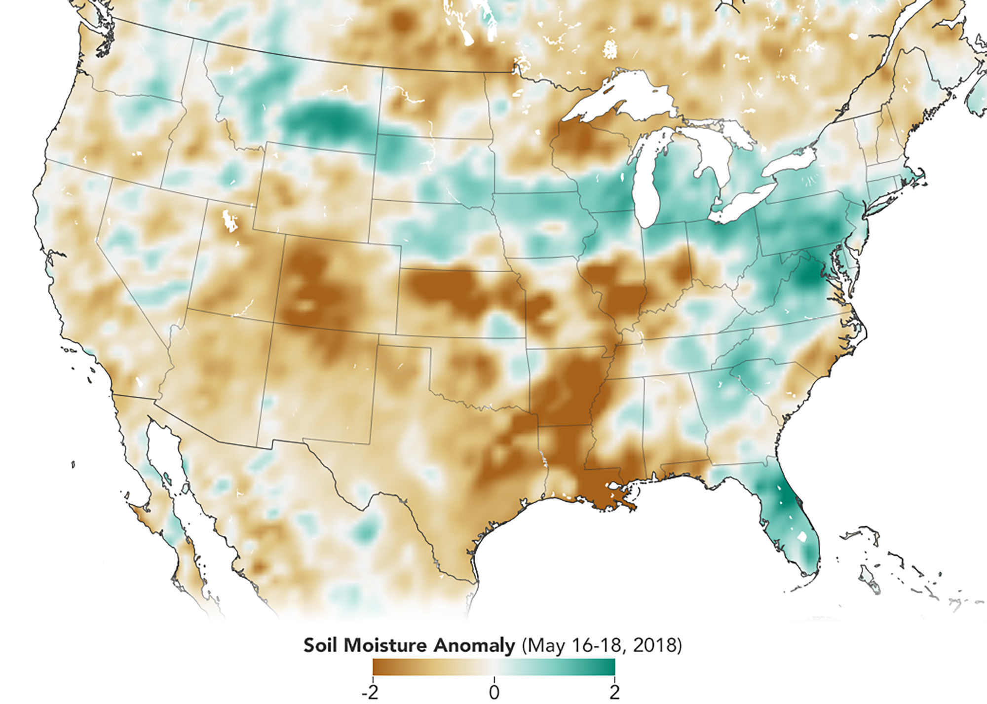 [With data from NASA’s Soil Moisture Active Passive satellite, researchers can monitor the amount of water in the soils to identify areas prone to droughts or floods. In this map created with SMAP data from May 16- May 18, 2018, soils that are wetter than normal are seen in greens, while those that are drier than normal are seen in browns. Credits: Joshua Stevens/NASA Earth Observatory]
Variations in global agricultural productivity have tremendous economic, social and humanitarian consequences. Among the users of this new SMAP data are USDA regional crop analysts who need accurate soil moisture information to better monitor and predict these variations.
“The USDA does crop forecasting activities from a global scale, and one of the main pieces of information for them is the amount of water in the soil,” said Iliana Mladenova, a research scientist at Goddard.
The USDA has used computer models that incorporate precipitation and temperature observations to indirectly calculate soil moisture. This approach, however, is prone to error in areas lacking high-quality, ground-based instrumentation. Now, Mladenova said, the agency is incorporating direct SMAP measurements of soil moisture into Crop Explorer. This allows the agriculture analysts to better predict where there could be too little, or too much, water in the soil to support crops.
These soil moisture conditions, along with tools to analyze the data, are also available on Google Earth Engine. There, researchers, nonprofits, resource managers and others can access the latest data as well as archived information.
[With data from NASA’s Soil Moisture Active Passive satellite, researchers can monitor the amount of water in the soils to identify areas prone to droughts or floods. In this map created with SMAP data from May 16- May 18, 2018, soils that are wetter than normal are seen in greens, while those that are drier than normal are seen in browns. Credits: Joshua Stevens/NASA Earth Observatory]
Variations in global agricultural productivity have tremendous economic, social and humanitarian consequences. Among the users of this new SMAP data are USDA regional crop analysts who need accurate soil moisture information to better monitor and predict these variations.
“The USDA does crop forecasting activities from a global scale, and one of the main pieces of information for them is the amount of water in the soil,” said Iliana Mladenova, a research scientist at Goddard.
The USDA has used computer models that incorporate precipitation and temperature observations to indirectly calculate soil moisture. This approach, however, is prone to error in areas lacking high-quality, ground-based instrumentation. Now, Mladenova said, the agency is incorporating direct SMAP measurements of soil moisture into Crop Explorer. This allows the agriculture analysts to better predict where there could be too little, or too much, water in the soil to support crops.
These soil moisture conditions, along with tools to analyze the data, are also available on Google Earth Engine. There, researchers, nonprofits, resource managers and others can access the latest data as well as archived information.
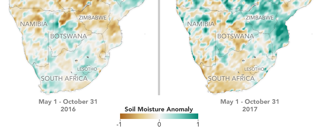 [NASA’s Soil Moisture Active Passive satellite takes global measurements, allowing researchers and resource managers to identify and compare regions that are drier (brown) and wetter (green) than normal, even if they are far from weather radar or water gauges. Credits: Credit: Joshua Stevens/NASA Earth Observatory)]
“If you have better soil moisture data and information on anomalies, you’ll be able to predict, for example, the occurrence and development of drought,” Mladenova said.
The timing of the information matters as well, she added — if there’s a short dry period early in the season, it might not have an impact on the total crop yield, but if there’s a prolonged dry spell when the grain should be forming, the crop is less likely to recover.
With global coverage every three days, SMAP can provide the Crop Explorer tool with timely updates of the soil moisture conditions that are essential for assessments and forecasts of global crop productivity.
For more than a decade, the USDA Crop Explorer products have incorporated soil moisture data from satellites. It started with the Advanced Microwave Scanning Radiometer-E instrument aboard NASA’s Aqua satellite, but that instrument stopped gathering data in late 2011. Soil moisture information from ESA’s (the European Space Agency) Soil Moisture and Ocean Salinity mission is also being incorporated into some of the USDA’s products. This new, high quality input from SMAP will help fill critical gaps in soil moisture information.
Edited for WeatherNation by Meteorologist Mace Michaels
[NASA’s Soil Moisture Active Passive satellite takes global measurements, allowing researchers and resource managers to identify and compare regions that are drier (brown) and wetter (green) than normal, even if they are far from weather radar or water gauges. Credits: Credit: Joshua Stevens/NASA Earth Observatory)]
“If you have better soil moisture data and information on anomalies, you’ll be able to predict, for example, the occurrence and development of drought,” Mladenova said.
The timing of the information matters as well, she added — if there’s a short dry period early in the season, it might not have an impact on the total crop yield, but if there’s a prolonged dry spell when the grain should be forming, the crop is less likely to recover.
With global coverage every three days, SMAP can provide the Crop Explorer tool with timely updates of the soil moisture conditions that are essential for assessments and forecasts of global crop productivity.
For more than a decade, the USDA Crop Explorer products have incorporated soil moisture data from satellites. It started with the Advanced Microwave Scanning Radiometer-E instrument aboard NASA’s Aqua satellite, but that instrument stopped gathering data in late 2011. Soil moisture information from ESA’s (the European Space Agency) Soil Moisture and Ocean Salinity mission is also being incorporated into some of the USDA’s products. This new, high quality input from SMAP will help fill critical gaps in soil moisture information.
Edited for WeatherNation by Meteorologist Mace Michaels
[With data from NASA’s Soil Moisture Active Passive satellite, researchers can monitor the amount of water in the soils to identify areas prone to droughts or floods. In this map created with SMAP data from May 16- May 18, 2018, soils that are wetter than normal are seen in greens, while those that are drier than normal are seen in browns. Credits: Joshua Stevens/NASA Earth Observatory]
Variations in global agricultural productivity have tremendous economic, social and humanitarian consequences. Among the users of this new SMAP data are USDA regional crop analysts who need accurate soil moisture information to better monitor and predict these variations.
“The USDA does crop forecasting activities from a global scale, and one of the main pieces of information for them is the amount of water in the soil,” said Iliana Mladenova, a research scientist at Goddard.
The USDA has used computer models that incorporate precipitation and temperature observations to indirectly calculate soil moisture. This approach, however, is prone to error in areas lacking high-quality, ground-based instrumentation. Now, Mladenova said, the agency is incorporating direct SMAP measurements of soil moisture into Crop Explorer. This allows the agriculture analysts to better predict where there could be too little, or too much, water in the soil to support crops.
These soil moisture conditions, along with tools to analyze the data, are also available on Google Earth Engine. There, researchers, nonprofits, resource managers and others can access the latest data as well as archived information.
[NASA’s Soil Moisture Active Passive satellite takes global measurements, allowing researchers and resource managers to identify and compare regions that are drier (brown) and wetter (green) than normal, even if they are far from weather radar or water gauges. Credits: Credit: Joshua Stevens/NASA Earth Observatory)]
“If you have better soil moisture data and information on anomalies, you’ll be able to predict, for example, the occurrence and development of drought,” Mladenova said.
The timing of the information matters as well, she added — if there’s a short dry period early in the season, it might not have an impact on the total crop yield, but if there’s a prolonged dry spell when the grain should be forming, the crop is less likely to recover.
With global coverage every three days, SMAP can provide the Crop Explorer tool with timely updates of the soil moisture conditions that are essential for assessments and forecasts of global crop productivity.
For more than a decade, the USDA Crop Explorer products have incorporated soil moisture data from satellites. It started with the Advanced Microwave Scanning Radiometer-E instrument aboard NASA’s Aqua satellite, but that instrument stopped gathering data in late 2011. Soil moisture information from ESA’s (the European Space Agency) Soil Moisture and Ocean Salinity mission is also being incorporated into some of the USDA’s products. This new, high quality input from SMAP will help fill critical gaps in soil moisture information.
Edited for WeatherNation by Meteorologist Mace MichaelsAll Weather News
More
East Gears Up for Stormy, Wet Weekend
A low pressure system crashing through the Mi
1 Aug 2026 11:35 AM


Flooding, Severe Storms Target the Midwest Again
After an active week of storms across the nor
1 Aug 2026 1:40 AM


After Reaching Category 5, Genevieve Weakens in the Pacific
PacificFausto is now a post-tropical cyclone.
31 Jul 2026 1:30 AM

Flooding Risk Increases as Heavy Rain Targets the Tri-State Area
Tuesday, heavy rainfall moved across the Nort
30 Jul 2026 12:25 AM

Severe Weather: Energy From the Midwest Now in the Southeast
UPPER MIDWEST - Through Monday, dangerous tor
29 Jul 2026 10:30 PM