Sub-Tropical Storm Vs. Tropical Storm... What's The Difference?
Special Stories
11 Oct 2019 9:00 AM
Tropical terminology can be very complicated to the general public. From tropical storm, to sub-tropical, extra-tropical and post-tropical...how is one to understand all of these terms and what it means to them? Understanding these terms can be important, but also, in general don't say much, if anything, about the possible impacts the system may bring. Impact details should be closely followed, as every tropical system is different. The terminology is a scientific classification of the type of system at hand.
Most of us are familiar with the term "Tropical" storm. But, let's break down the science of some other common "tropical" terms.
A subtropical storm is actually a hybrid of an extra-tropical storm, and a tropical storm. So we'll identify all three types of storms.
TROPICAL STORM
A tropical storm is very different. It has a warm core at its central point. It's very symmetrical in structure, and does not have temperature and moisture differences radiating out from the center of circulation. These storms typically form over large bodies of warm water. The warm water is the energy source for these storms. Ocean water evaporates, and then condenses back into water droplets. This process releases energy back into the storm, allowing it to increase in strength, when favorable environmental conditions exist. This is very different from extratropical storms, which are fueled by differences in temperature and moisture over a given region.
SUB-TROPICAL STORM
A subtropical storm has characteristics of both a tropical storm and an extratropical storm. They form initially from extratropical storms, which have colder temperatures in the upper levels of the atmosphere than are typically found in the tropics. Therefore, they can form in areas where sea surface temperatures are cooler than those needed for tropical systems to initiate. Since warmer ocean water is not as necessary, subtropical storms can also form earlier or later than the normal dates for hurricane season. Typically, what happens is that an extratropical storm will drop southward into the warmer regions of the subtropics. The system then gets blocked by a big ridge of high pressure, and gets cut-off from the cooler and drier air of the higher latitudes. The system them begins to gain more tropical characteristics in its new environment. As the system gains more tropical characteristics, it will eventually transition into a tropical storm.
In short, a subtropical storm forms when it is no longer an extratropical storm, but doesn't possess all the characteristics of a tropical storm. It is in a sense a hybrid storm system. This is when the storm is designated "subtropical".
EXTRA-TROPICAL STORM
An extratropical storm has a cold core at its central point. It is often associated with frontal zones, such as warm fronts and cold fronts. These fronts are essentially lines marking areas of different temperatures and dew points. For example, air masses to the east of a cold front are warm and moist compared to cooler and drier air behind the cold front. We see these kind of systems regularly on the U.S. mainland. They drive our daily weather patterns. These are mid-latitude storm systems, usually forming between 30 and 60 degrees latitude. They produce most of the weather we see here in the United States. Everything from light rain, to super cell thunderstorms with damaging winds, hail, and tornadoes. Snowstorms and blizzards also form with these systems.
TECHNICAL BREAKDOWN
TROPICAL SYSTEM
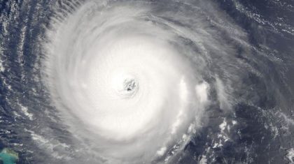 The picture above is a well defined hurricane. You can easily see the symmetrical structure around a clearly defined eye, which is the center of the storm.
SUBTROPICAL SYSTEM
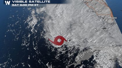 (From May 2018, Subtropical Storm Alberto located off the west coast of Florida)
The picture above is Subtropical Storm Alberto, which formed in May 2018. The center of circulation is denoted by the red subtropical storm icon. Notice how the western portions of the storm are dry and cloud-free. The clouds, rain, and thunderstorms are all on the eastern side of the system. This is the typical asymmetrical structure for a subtropical system.
In time, under the right environmental conditions, a subtropical storm can become a tropical storm. It can then further strengthen into a hurricane. When a system has winds between 39 mph and 73 mph, it is termed a Tropical Storm. Once sustained winds hit 74 mph, it reaches hurricane status.
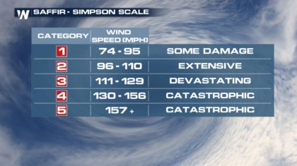
There are five categories of hurricanes. The Saffir-Simpson Scale is used to classify hurricanes.
 Hurricane season begins June 1st and runs through November 30th. Of course, storms can form outside of the official season. Alberto has proven this point already!
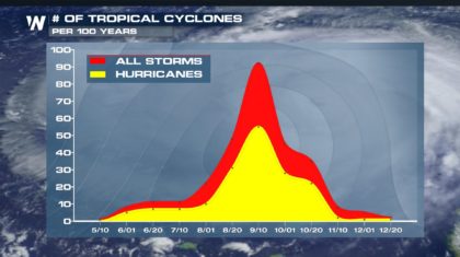
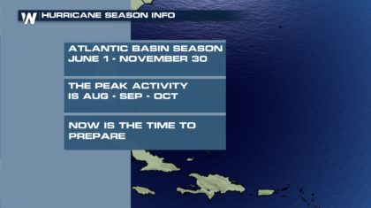 Hurricane season activity usually peaks in August, September, and October. This makes sense. Warm core systems need warm ocean water to supply the energy need for formation and growth. It is no coincidence that these are the months when ocean waters are the warmest.
- Warm core.
- Symmetrical on all sides with respect to temperature and dew points
- Thunderstorms near center of circulation and wrapped around low pressure.
 The picture above is a well defined hurricane. You can easily see the symmetrical structure around a clearly defined eye, which is the center of the storm.
SUBTROPICAL SYSTEM
- Cold core.
- Asymmetrical structure with temperature and dew points. The eastern side of the storm will be warmer with higher dew points and more moisture. This is where the showers and thunderstorms will be. The western side of the storm will be cooler, drier, with no clouds and rain.
- Thunderstorms will be a far away from the center of the storm.
 (From May 2018, Subtropical Storm Alberto located off the west coast of Florida)
The picture above is Subtropical Storm Alberto, which formed in May 2018. The center of circulation is denoted by the red subtropical storm icon. Notice how the western portions of the storm are dry and cloud-free. The clouds, rain, and thunderstorms are all on the eastern side of the system. This is the typical asymmetrical structure for a subtropical system.
In time, under the right environmental conditions, a subtropical storm can become a tropical storm. It can then further strengthen into a hurricane. When a system has winds between 39 mph and 73 mph, it is termed a Tropical Storm. Once sustained winds hit 74 mph, it reaches hurricane status.
There are five categories of hurricanes. The Saffir-Simpson Scale is used to classify hurricanes.
 Hurricane season begins June 1st and runs through November 30th. Of course, storms can form outside of the official season. Alberto has proven this point already!
 Hurricane season activity usually peaks in August, September, and October. This makes sense. Warm core systems need warm ocean water to supply the energy need for formation and growth. It is no coincidence that these are the months when ocean waters are the warmest.

All Weather News
More