The Inland-Coastal Flooding Operational Guidance System
Special Stories
7 Jan 2021 1:51 AM
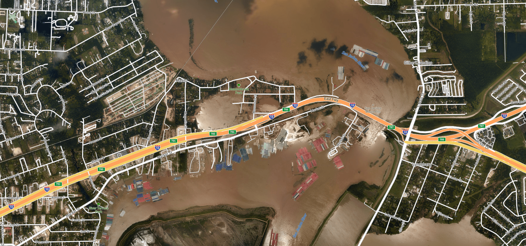
[Aerial imagery of inland-coastal flooding during Hurricane Harvey, 2017 in Houston, Texas. Credit: NOAA Remote Sensing Division]
[Written by NOAA] Where the river meets the sea can be both a turbulent and vulnerable space, particularly during strong storms when heavy precipitation and storm surge intersect. This intersection is known as “compound inland-coastal flooding,” and until now, had not been carefully studied and implemented in forecasting centers for public guidance due to its inherent complexity. NOAA’s Office of Coast Survey and the Virginia Institute of Marine Science recently developed the Inland-Coastal Flooding Operational Guidance System (ICOGS), the world’s first three-dimensional integrated compound inland-coastal flooding guidance system.
The increasing number of compound inland-coastal flooding events in recent years highlights the urgency for developing modeling capabilities to provide accurate guidance for wet storms such as Hurricane Harvey, 2017, and Hurricane Florence, 2018, with concurrence of storm surge and heavy precipitation. Guidance provided by ICOGS will benefit emergency response, disaster mitigation, and coastal resiliency efforts before, during, and after storm events.
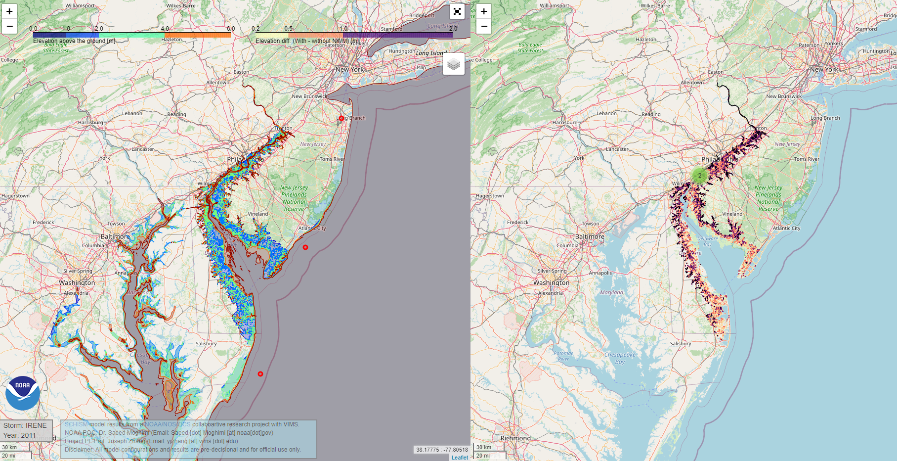 [Creek-to-ocean 3D model results including NWM streamflow and precipitation for predicting the impact of Hurricane Irene (2011) zoomed in Trenton, NJ region. A) Model domain. Circles show Hurricane Irene (2011) track. B) High resolution mesh on the Delaware Bay region. C) Total water level above the ground. D) Extra inundation (up to 2 m) due to compound inland-coastal and freshwater flooding]
In addition, an important product of a three-dimensional model based guidance system is to support safe and precise navigation during normal and storm times by providing mariners with reliable information on water levels, surface currents, and vertical stratification.
Results of this groundbreaking work were presented in several venues including 2nd International Workshop on Waves, Storm Surges & Coast Hazards 2019, American Meteorological Society Annual Meeting (AMS) 2020 and American Geophysical Union – Ocean Science Meeting 2020 in addition to 4 peer-reviewed publications (Ye et al. 2019; Zhang et al. 2020; Huang et al. submitted; Ye et al. submitted).
Coast Survey and the Virginia Institute of Marine Science developed the modeling system starting from basic science concepts all the way to a pre-operational capacity producing once a day forecasts. The next steps will be to transition this modeling guidance system to full operational capacity in Coast Survey to further support disaster mitigation, coastal resilience, and navigation. This effort is supported through the NOAA Water Initiative (NWI) and the NOAA National Oceanographic Partnership Program (NOPP).
[Creek-to-ocean 3D model results including NWM streamflow and precipitation for predicting the impact of Hurricane Irene (2011) zoomed in Trenton, NJ region. A) Model domain. Circles show Hurricane Irene (2011) track. B) High resolution mesh on the Delaware Bay region. C) Total water level above the ground. D) Extra inundation (up to 2 m) due to compound inland-coastal and freshwater flooding]
In addition, an important product of a three-dimensional model based guidance system is to support safe and precise navigation during normal and storm times by providing mariners with reliable information on water levels, surface currents, and vertical stratification.
Results of this groundbreaking work were presented in several venues including 2nd International Workshop on Waves, Storm Surges & Coast Hazards 2019, American Meteorological Society Annual Meeting (AMS) 2020 and American Geophysical Union – Ocean Science Meeting 2020 in addition to 4 peer-reviewed publications (Ye et al. 2019; Zhang et al. 2020; Huang et al. submitted; Ye et al. submitted).
Coast Survey and the Virginia Institute of Marine Science developed the modeling system starting from basic science concepts all the way to a pre-operational capacity producing once a day forecasts. The next steps will be to transition this modeling guidance system to full operational capacity in Coast Survey to further support disaster mitigation, coastal resilience, and navigation. This effort is supported through the NOAA Water Initiative (NWI) and the NOAA National Oceanographic Partnership Program (NOPP).All Weather News
More
Flooding Risk Increases as Heavy Rain Targets the Tri-State Area
Tuesday, heavy rainfall moved across the Nort
30 Jul 2026 12:25 AM


Genevieve Down to a Category 2 Hurricane
PacificFausto is now a post-tropical cyclone.
30 Jul 2026 12:00 AM

Severe Weather: Energy From the Midwest Now in the Southeast
UPPER MIDWEST - Through Monday, dangerous tor
29 Jul 2026 10:30 PM


Southeast Flood Risk Lingers Near Stalled Front
A stalled boundary over the Southeast will ke
25 Jul 2026 10:55 AM

Another Round of Storms Targets the Northeast
Tuesday brought severe weather again across p
23 Jul 2026 1:15 AM